
Research article · 2024 · Full text
International Journal of Geography Geology and EnvironmentA study of agriculture land use efficiency of Dhule district: A geographical analysis
Volume 6(1) · Pages 170–173 · DOI: 10.22271/27067483.2024.v6.i1c.217 ↗
Research areasAgricultural Economics and Practices
Abstract
Author-writtenWith significant socioeconomic development and a growing population, promoting land-use efficiency is, and will remain, the crucial land-use planning issue in China. This study analyzed the characteristics of land-use intensity and programmed industrial land-use planning. The data used in this study were collected from interviews with enterprises, the land registry, administrative committees of the development zones, the first distribution record of the state land-use rights certificates, and Shunyi's economic records. The evaluation of land-use efficiency involved comparing sectors, locations inside and outside development zones, land obtained by transaction or otherwise, and changes over time. Unlike standard dominant industry selections, this study considered the role of intensive land-use crucial to industrial development planning. This land-use efficiency analysis and industrial development planning enabled industrial land-use planning to be accomplished in three important and difficult respects: quantity, arrangement, and scheduling. There is scope for extension of cultivated land by bringing fallow land potential agricultural land under cultivation. Therefore, immediate need is to give more emphasis on intensity of cropping and increasing yield from existing calculated are problem of under use of net sown area low productivity and kicks of crop failure are tarring the rural population. Therefore, it is fruitful to investigate the degree of intensity with which the net sown area is utilized.
Summary
Source-checkedPlain-language reading of the full paper, prepared with AI and checked against the text. Each point links to the authors' own words.
Why it matters
- There is an urgent need to increase cropping intensity and yields because the under-utilization of net sown area and low productivity are negatively impacting rural populations. View evidence ↗
- Agricultural land use efficiency is defined as the intensity of cropping, measured by the percentage of the net sown area that is cropped or re-sown. View evidence ↗
What they did
- The research was conducted in the Dhule district of Maharashtra, specifically focusing on four tahsils: Dhule, Sakri, Shirpur, and Sindkheda. View evidence ↗
What they found
- In 2010-2011, the region had an average gross cropped area of 390,458 hectares and a net sown area of 367,443 hectares, resulting in a land use efficiency index of 106.26%. View evidence ↗
- During 2010-2011, efficiency varied by tahsil: Dhule and Shindkheda were below 105%, Sakri was between 105-110%, and Shirpur was above 110%. View evidence ↗
- By 2020-2021, land use efficiency was below 125% in Dhule Tahsil, while Sakri, Shindkheda, and Shirpur Tahsils all exceeded 125%. View evidence ↗
- Sakri and Dhule Tahsils were categorized as areas of medium intensity, defined as having efficiency between 120% and 130%. View evidence ↗
- Shindkheda and Shirpur Tahsils were identified as high intensity areas, with efficiency levels above 130%. View evidence ↗
What it means
- The authors conclude that variations in land use efficiency are primarily driven by irrigation availability, agricultural practices, and physical environmental constraints like soil type and rainfall. View evidence ↗
Visual summary
3 visualsIllustrations explain the paper; charts are replotted from the paper's own table values.
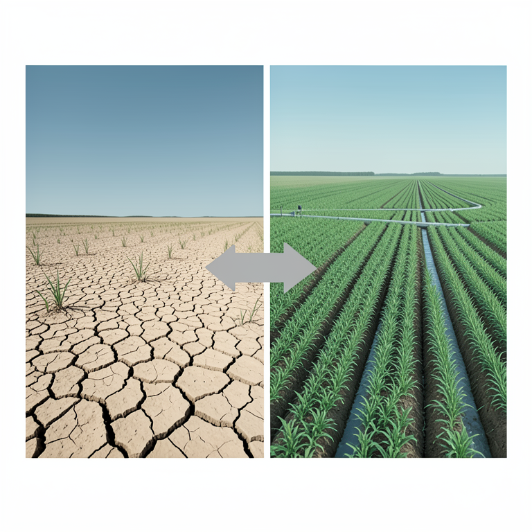
Drivers of Land Use Efficiency
AI-generated conceptual illustration (Agricultural landscapes of Dhule district, Maharashtra). It explains the idea and does not show study data.
View source evidence ↗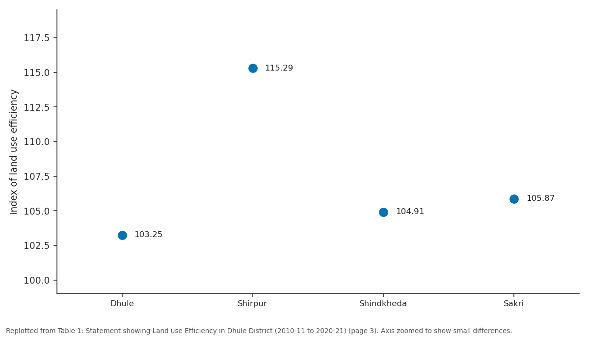
Index of land use efficiency: Dhule vs Shirpur vs Shindkheda vs Sakri
Replotted from Table 1 (page 3) of the original paper. Every bar is the paper's own table value.
View source evidence ↗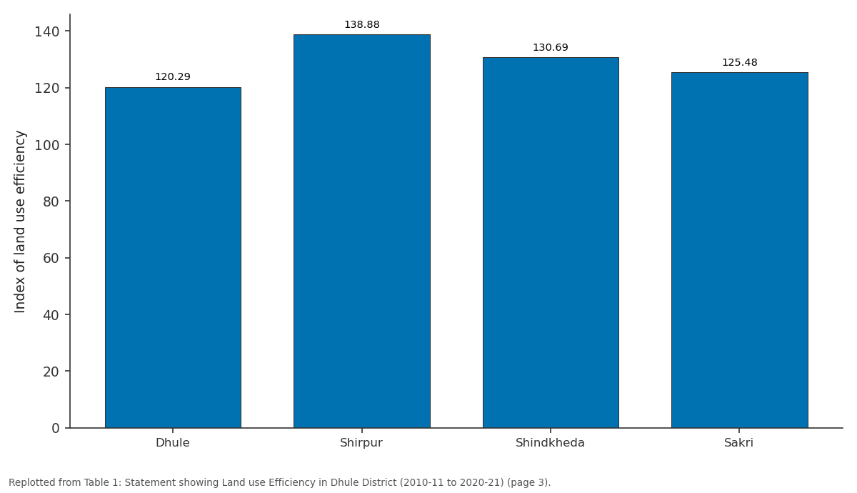
Index of land use efficiency: Dhule vs Shirpur vs Shindkheda vs Sakri
Replotted from Table 1 (page 3) of the original paper. Every bar is the paper's own table value.
View source evidence ↗Figures & tables
From the original paper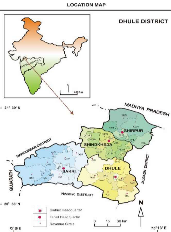 Figure 1
 Table 1
Introduction
Land use efficiency may be defined as the extent to which the net sown area is cropped or resown. The gross cropped areas percentage of the net sown area gives a measure of land use efficiency which means the intensity of cropping. The difference between land use and land utilization is important. Land use is the use actually made of any parcel of land; house, apartments and industrial location are land use categories, whereas the term residential, industrial and agricultural refer to a system of land utilization implying roads, neighborhood retail and service activities as well as location of industries and the carrying of agricultural pursuit [3] . In a rural area, tree crop or row crop would identify land use, where orcharding, truck farming and grazing indicate a system of land utilization. The term 'land utilization' is also used for varied utilization of land and soil surveys e.g. land under cultivation, pasture barren, orchard, fallows, waste, culturable waste, settlements, forests, water bodies etc. According to J.L. Buck "Land utilization is the satisfaction, which the farm population dories from the type of agriculture developed, the provision for future production and contribution to national needs" (Quoted 1951) [4] . While the definition given by Salter is as follows: "Land utilization research can be described as dealing with problem situations in which people in a given locality are in the process of transformation from activities with certain land requirements to activities with different land requirement [5] ." In this sense land utilization involves an examination of the natural factor affecting both the harnessed and the potential productivity of the land is a changed situation of the locality and its requirements. These factors are the land, temperature, rainfall and soil, which in a configuration together constitute the physical background of agriculture and determine the limits of both the cultivability and productivity of the land. Land utilization mainly deals with the problems related to the society and the region as a whole, rather than a private farmer. Land use is mainly related to the optimum use of the limited land between the alternative major types of land use.
Study area
Dhule district lies in state of Maharashtra. Dhule district, previously known as west Khandesh is in northern part of Maharashtra State. It is bounded between north latitude 20°38' to 21°61' and east longitude 73°50' to 75°11'(E with altitude of 180 to 250 meters above mean sea level. The district is limited by Nandurbar district in the north-west, Nashik district in south and Jalgaon district in east. The district headquarters is located at Dhule city. For administrative suitability, the district is divided into 4 tahsils viz., Dhule, Sakri, Shirpur and Sindkheda. The district has a geographical area of 8061 sq. km. out of which 2051 sq. km. is covered by forest, whereas cultivatable area is 4752 sq. km. and net sown area is 4966 sq. km. Agriculture is the main profession of the people. The entire district forms a part of the Tapi basin. It has a total population of 2,050,862 as per 2011 census. The district has 4 towns and 683 villages. Tapi is the main river flowing through the district.
Objective
The main objective of the study area 1. To study for the agriculture efficiency of the study region. 2. To understand the region agriculture efficiency the study region. 3. To suggest the remedies to increase the agriculture efficiency for sustainable development.
Data Base and Methodology
Present study mostly relied on the secondary data collected through Agriculture Development and district statistical Department of Dhule District socio-economic abstract of Dhule District. For the present investigation, eleven cropps are selected Simple statistical methods has used to present study. In order to assess the agricultural efficiency, the following formula.
The eleven tahsils of district done as shown in table . After words index of land efficiency is calculated by above formula for each district. There are regional variations in index of various tahsils of district. The index value is classified and interpretation gives the proper results.
Explanation and Result
Agriculture efficiency is a scientific device to study the infertility productivity and capacity of the land so that its misuse and underuse can be cheeked by planning for further use. The object of land use is to ensure the productivity and efficiency of agricultural land and its should be based on a real appreciation of the agricultural needs, including the relative agricultural valve of land in a locality, several methods have been used to measure the agricultural efficiency with same virtues and short coming in them. Dhule district Agricultural efficiency is measured in the following table.
Area of low intensity (Below 125 percent)
Are of low intensity area distributed in Dhule, Shindkheda, Sakri, Shirpur Tahsil. Soil conditions use of chemical fertilizers, pesticides, variety seeds, physiographic irrigation all these factors are the causes of low intensity.
Area of medium intensity (120 percent to 130 percent)
Area of medium intensity are confirmed to Sakri and Dhule Tahsil. Percentage of Physiography, irrigation, soil conditions, manures etc. are responsible for the medium intensity.
Area of High Intensity (Above 130 percent)
High intensity was found in Shindkheda and Shirpur Tahsils, physical and non-physical factors are responsible for the high intensity of land use.
Strategy for growing land use efficiency
1. To use new Agricultural technology. 2. To increase the source of irrigation and develop new irrigation mode. 3. To develop the crop insurance. 4. To develop the transport network. 5. To arrange the agricultural conference and increase the agricultural. 6. To develop the agricultural education in rural area. 7. To alternate the fallow land to Agricultural land.
Conclusion
Variation in land use efficiency are mainly confined to the irrigation possibilities pattern of agricultural practices crops and limitations imposed by the physical environment as the soil types, physiography and nature of rainfall distribution etc. On the strength of percentage to the region is divided into three categories viz. Low intensity, medium intensity and high intensity. Area of low intensity below 125 percent Dhule, Shindkheda, Sakri, Shirpur Tahsil. Percentage of irrigation. Physiography. Soil, condition use of chemical fertilizers, pesticides, high yielding variety seeds all these factors is responsible for low intensity. Areas of medium intensity 120% to 130% are confined to Sakri and Dhule Tahsil. Percentage of Physiography, irrigation, soil conditions, manures etc. are responsible for the medium intensity. Area of high Intensity Above 130% High intensity was found in Shindkheda and Shirpur Tahsils, physical and non-physical factors are responsible for the high intensity of land use.
Figures and tables from the paper
| Tahsil | 2010-2011 | — | — | 2020-2021 | — | — | Valum of change in land use efficiency |
|---|---|---|---|---|---|---|---|
| Gross cropped area | Net Sown area | Index of land use efficiency | Gross cropped area | Net Sown area | Index of land use efficiency | ||
| Dhule | 112985 | 109433 | 103.25 | 129468 | 107629 | 120.29 | -17.04 |
| Shirpur | 63569 | 55138 | 115.29 | 135645 | 97674 | 138.88 | -23.59 |
| Shindkheda | 96100 | 91600 | 104.91 | 125036 | 95677 | 130.69 | -25.78 |
| Sakri | 117804 | 111272 | 105.87 | 135282 | 107814 | 125.48 | -19.61 |
| Total | 390458 | 367443 | 106.26 | 525431 | 408794 | 128.53 | -22.27 |
Table text extracted from the original PDF; superscript letters are shown inline. The original table image is below.
View original table image
References
3 in the original paper- Kendall MG. The geographical distribution of crop productivity in England. Journal of the Royal Statistical Society. 1939;102(1):21-62.
- Khan YS. Agricultural Issues and Sustainable Development. Earth Exploration, AEEI. 2011;2(1):7893.
- Bhaskar BP, Maske S, Ramesh Kumar SC, Srinivas S, Hegde R. Agropedological Approach for Rural Land Use Planning-A Case Study from Lagadwal Village, Dhule District, Maharashtra, India. International Journal of Current Microbiology and Applied Sciences. 2018;7(2):2528-2541.
Cited by 8
From OpenAlex, OpenCitations and reference lists read by Scinovex
- The transformative potential of precision farming in India: A comprehensive review
Pooja Ranee Behuria, Subhrajit Ojha, Lopamudra Nayak, Joydeep Kumar Kar, Deeptimayee Gochhayat, N. K. Jaiswal · International Journal of Research in Agronomy · 2024
Precision farming represents an innovative approach to modern agriculture, optimizing crop production through site-specific management of resources. With the use of cutting-edge technology like Geographic Information Systems (GIS), remote sensing, satellite images and artificial intelligence (AI), this system tracks crop conditions, soil health and climate trends constantly. Precision farming reduces resource waste and environmental effects by using these technologies to apply water, fertilizer and pesticides more efficiently. This strategy tackles important issues with food security and susta
- Changing land use and crop dynamics in bifurcated Andhra Pradesh
Govindaraju Govindaraju, K. M. Pravalika, KJVK Sirisha, Y. Radha, Idupulapati M. Rao · International Journal of Agriculture Extension and Social Development · 2025
This study investigates shifts in land use patterns and cropping dynamics in Andhra Pradesh over recent decades. Factors like economic liberalization, policy changes, and environmental challenges have affected traditional farming practices and crop diversity. Statistical methods like Composite Entropy Index (CEI), Herfindahl Index (HI), Double Log model, and Markov Chain Analysis were applied to examine crop diversification, the driving factors behind diversification, and the dynamics of cropping patterns in the state. The study also examined trend in crop shifts, irrigation practices, and lan
- Optimizing micro irrigation efficiency in water-scarce agroecosystems using AI and remote sensing technologies
Balwinder Kumar, K. Sivakumar, Sidharth M Nair · International Journal of Biology Sciences · 2025
In dryland farming, water shortages require creative irrigation solutions. In dry and semi-arid areas, drip, sprinkler, and subsurface irrigation are becoming more popular to maximize water use. These systems still struggle to distribute water efficiently, use a lot of energy, and make real-time decisions. Using AI and remote sensing to overcome these restrictions is revolutionary. AI-driven irrigation systems use machine learning algorithms, predictive analytics, and IoT-enabled smart sensors to maximize water use, minimize waste, and increase crop yields. UAVs, satellites, and multispectral
- Evaluating agricultural patterns and crop shifts in Vadodara-Chhotaudepur District of Gujarat, India
K. G. Parmar, Bindu Bhatt · International Journal of Agriculture and Food Science · 2025
India is an agrarian country, and agriculture is one of the major sources of food and income in India. Around 20% of Gujarat's economy comes from agriculture sectors. There are observable shifts in Gujarat's crop patterns, land use, and productivity. Many districts in Gujarat are experiencing administrative and environmental changes. The study assesses long-term agriculture patterns from the year 1997-98 to 2022-23 in five-year intervals. The analysis focuses on ten major crops of the region, representing both Kharif and Rabi seasons. Parameters such as agricultural area, production, and yield
- Reimagining crop rotation for resilient and sustainable intensification in Sub-Saharan Africa: Innovations, gaps, and scalable pathways
Benjamin Yennuna Konyannik, Jessica Ampah-Korsah, Foster Mensah, Paa Kwesi Afful, Amakye Sheila Efua Anama · International Journal of Agriculture and Food Science · 2025
Compounding agricultural issues in Sub-Saharan Africa (SSA) include population pressure, land fragmentation, and climate variability, all of which endanger environmental sustainability and food security, reduce agricultural resilience, and exacerbate rural poverty. Over 90% of farming in SSA being rain-fed, the sector is vulnerable to climate variability. Despite these challenges, SSA holds potential for agricultural transformation through innovative, sustainable farming practices like agroecology, climate-smart agriculture, and organic techniques. One important but little-used tactic for boos
- A review on Agronomy in aspect of practice sustainable agriculture flow
Deepa Tomar, Surendra Singh Bhadoria · International Journal of Horticulture and Food Science · 2025
Through this review we focusing on the systematic flow and outreaches of the Practicing Agricultural values in respect of agronomy for general growth and development of field analysis and diversification in the crop yielding methods.
- Forecasting land utilization of India and Maharashtra using ARIMA model
RS Jachak, OM Gawas, Manish Sawant, P. V. Phadte, TV Navghare · International Journal of Agriculture Extension and Social Development · 2024
India is an agricultural country with Maharashtra state as its major contributor to the agriculture sector. In agriculture, land is the most important component. Hence, the land utilization pattern of India and Maharashtra state has been studied during this analysis over the past 11 years (2011-2022). The ACF (Auto Correlation Function) and PACF (Partial Auto Correlation Function) were calculated for the data. The future aspect of land by forecasting land utilization for the next 10 years has been done by using the Appropriate Box-Jenkins ARIMA (Auto Regressive Integrated Moving Average) model
- Atmanirbhar Bharat @ 2047: Vision for a self-reliant India through higher education ↗
R. Pavithra Devi · International Journal of Financial Management and Economics · 2024
This paper explores the role of higher education in realizing the vision of Atmanirbhar Bharat @ 2047, a long-term developmental roadmap aimed at making India self-reliant in every critical sector. As India celebrates 100 years of independence in 2047, higher education is expected to play a catalytic role in nurturing innovation, entrepreneurship, global competitiveness, and human capital development. The paper