
Research article · 2024 · Full text
International Journal of Geography Geology and EnvironmentGeological environmental study of Al-Dalmaj marsh area: Review
Volume 6(2) · Pages 138–145 · DOI: 10.22271/27067483.2024.v6.i2b.298 ↗
Research areasMarine and environmental studiesTransboundary Water Resource Management
Abstract
Author-writtenThe revision aims to present the most important studies that dealt with the Dalmaj Marsh Region, which is located in central Iraq between the governorates of Wasit and Al-Diwaniyah, because of its great biological and environmental importance, both for the neighboring region in particular and for the environment of Iraq in general. Through reviewing some studies, the revision reached several conclusions, including that the region was studied from the environmental, biological, hydrological, tourist and geochemical aspects to know the nature of the water in the region and its suitability for various purposes. These studies showed valuable results that can be taken into account by the relevant responsible authorities and decision-makers for the development of the region. The researchers suggested that it could become a natural tourist reserve with an economic resource that provides the Iraqi natural environment with biological and economic diversity.
Summary
Source-checkedPlain-language reading of the full paper, prepared with AI and checked against the text. Each point links to the authors' own words.
Why it matters
- The Al-Dalmaj marsh region in central Iraq is of significant biological and environmental importance to both its immediate surroundings and the country as a whole. View evidence ↗
- The region currently faces a loss of biodiversity and environmental imbalance caused by drought, high temperatures, increased evaporation, and low water revenues. View evidence ↗
The question
- The review aims to synthesize key studies on the Al-Dalmaj marsh to understand the nature of its water and determine its suitability for different uses. View evidence ↗
What they did
- The reviewed research focuses on a study area of approximately 314 square kilometers across the Wasit, Tiqqar, and Qadisiya provinces in the Mesopotamian plains. View evidence ↗
- The topography of the area is characterized as flat with an average height of 4.5 meters and a general slope from the northwest to the southeast. View evidence ↗
What they found
- Water in the Al-Dalmaj marsh is suitable for irrigation but is unfit for drinking, animal consumption, or construction purposes. View evidence ↗
- Water analysis showed temperatures between 9-34 °C, salt levels from 1.5-14.6%, neutral to alkaline pH, and dissolved oxygen levels between 7.2-9 mg/L. View evidence ↗
- The lake water is classified as very hard, with total hardness values measured between 825 and 6880 mg/L. View evidence ↗
- A study of benthic invertebrates found 21,286 individuals across nine taxonomic ranks, with crustaceans being the most predominant group at 6,238 individuals (29%). View evidence ↗
- Remote sensing data revealed an inverse relationship between temperature and vegetation, where lower temperatures correlate with the presence of water and plants. View evidence ↗
- The region is severely impacted by desertification, manifested as deteriorating vegetation, encroaching sand dunes, and soil salinization and waterlogging. View evidence ↗
- Land cover analysis showed the worst degradation in 1976, a period of regrowth and peak vegetation cover in 1990, and a subsequent negative change from 1990 to 2002. View evidence ↗
What it means
- The authors suggest transforming the Al-Dalmaj marsh into a natural tourist reserve to create an economic resource and preserve biological diversity. View evidence ↗
- The authors conclude that natural beauty alone is insufficient for tourism; success requires infrastructure, specifically a reliable transportation network and accommodation facilities. View evidence ↗
Visual summary
1 visualsIllustrations explain the paper; they do not show study data.
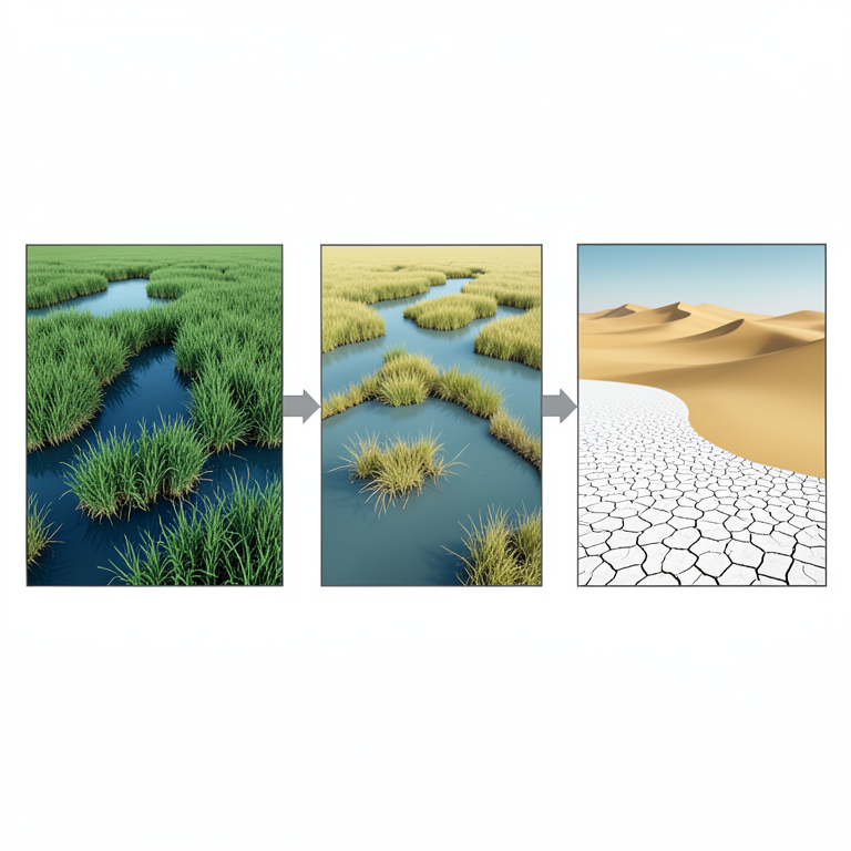
Desertification Cycle
AI-generated conceptual illustration (Al-Dalmaj marshland ecosystem). It explains the idea and does not show study data.
View source evidence ↗Figures & tables
From the original paper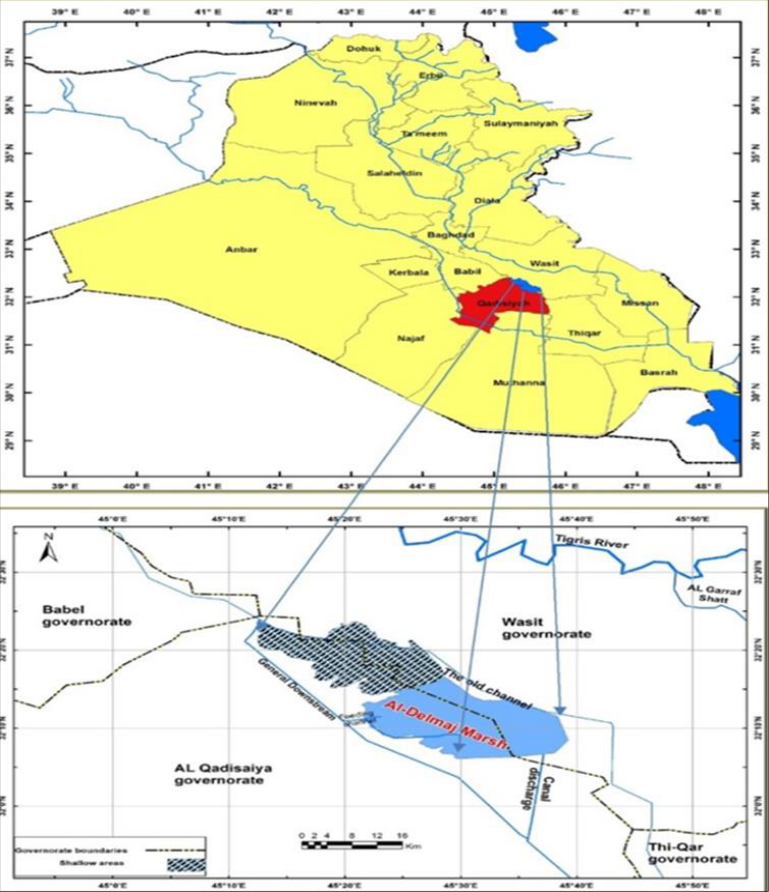 Figure 1
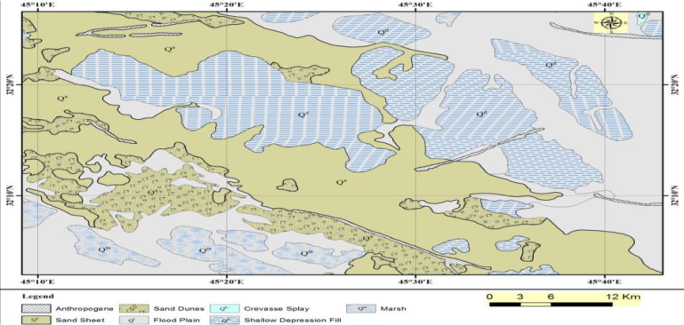 Figure 2
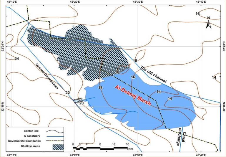 Figure 3
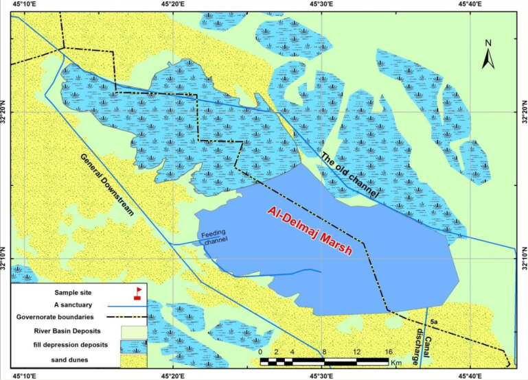 Figure 4
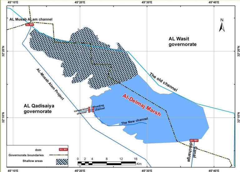 Figure 5
Introduction
Natural lakes represent good places for storing water at a time when its levels rise in the main rivers during the flood season and releasing it during the season of water scarcity to the rivers that humans rely on for agricultural and industrial purposes. Thus, Dalmaj Lake, which is administratively affiliated with the governorates of Wasit and Diwaniyah, represents, from a geomorphological standpoint, a natural depression in the middle of irrigation and drainage projects. Located between the Tigris and Euphrates Rivers and its major role in maintaining the water balance in the General Downstream project. Interest in studying the marshes in southern Iraq began in the seventies, north of the Chibaish Marsh (Pankow, et al., 1979) [18] and various areas of the southern marshes (Maulood, et al., 1979) [17] and the Hammar Marsh (Islam, 1982) [15] . After the year 2003, the marshes were revived, water sources were opened, and interest in the marshes began. Numerous studies were conducted and the current prevailing aquatic plants were compared with the marshes at the past period of political dictation and drying (Alwan, 2006) [9] . There are areas that have not been studied in detail, especially the marshes of central Iraq, such as the Dalmaj Marsh.
The lake forms the central part of the General Downstream. In the decade of the fifties of the last century, the lake was a shallow depression surrounded by dry lands in the summer or muddy lands in the winter and spring. After reclaiming the lands, the Dalmaj marsh was used for the first time to pour many trocars into it, and the marsh was transformed into a natural trocar. In the year 1992 The General Downstream Project was linked to Dalmaj Lake and used as a regulatory reservoir for water carried from the General Downstream, evaporated water, and water released to the General Downstream, while reducing peak water discharge. It was named an evaporative lake due to the great sunshine of (3350 hours/year) (Fahd et al. (2000) [12] . The Dalmaj Marsh is considered a natural environment with its various plant and animal resources. Currently, the region is suffering from a loss of biodiversity, which is one of the important problems that has a major impact on achieving environmental balance due to drought, low water revenues, high temperatures, and increased evaporation rates, and this is what negatively affects its area and characteristics.
The Study Area
The Al-Dalmaj area is one of the depressions formed during the Quaternary (Holocene) period.
Major changes occurred during the late Ice Age, such as large earth movements and significant climate changes. As a result, depressions such as Al-Dalmaj were formed and filled with younger sediments. The age of these sediments is no more than 10,000 years, so the age of the sediments can be traced back to the Holocene. Climate changes that occurred 9,000 years ago or earlier led to warmer and wetter summers and colder winters. Iraq has a typically arid climate due to the general drought in most of the southern and central parts of the country. There are other deposits, including As-Sabkha and aeolian deposits, which probably extend over large areas of Iraq. These marshes were formed under the same conditions as about 6,000-9,000 years ago. Dunes and praia lake deposits consist of sand, silt, and clay. These sediments come from the Tigris and Euphrates rivers, and wind promotes deposition, which results in the formation of dunes. There are chemical deposits such as gypsum, carbonates, secondary evaporation, etc. The study area forms the central part of the General Downstream project area, which dates back to the 1950s as a shallow depression. Most of the area is dry in summer and wet in winter or spring and after reclamation. Al-Dalmaj Lake is used to irrigate Musayyib and transform the marshland into a natural habitat. Irrigation water should flow directly to these areas. After the expansion of the irrigation and drainage network to numerous agricultural areas in Iraq. Since 1992, the establishment of the General Downstream project has been connected to Al Dalmaj Lake. In order to highlight the geomorphic features of the Al-Dalmaj area, the construction of the downstream integrated project was launched. The study area covers the central and southern Mesopotamian plains and covers an area of about 314 square kilometers. It is located in the Wasit, Tiqqar and Qadisiya provinces. It is bounded by the Qaraf River in the east and the Diwaniya and Euphrates rivers in the west. The coordinates of this area range from longitude 44°56′50″ to 45°44′52″ and latitude 32°38′00° to 31°49′00″ (Figure 1). Faults in tectonic movements extended their influence to the study area, which happens to be located within the main syncline of the Mesopotamian plain uplands to the east and northeast and the plateau to the west. Therefore, major and minor faults in the southeast of the lake played a huge role in its formation. As can be seen from the geological column of the area, the rocks at the bottom are composed of two geological structures:
1. Fatha Formation (Middle Miocene): This formation is widespread and has great economic significance. In Iraq, its thickness is quite large. It consists of evaporite minerals gypsum, anhydrite and rock salt, intercalated with limestone and marl (Bellen et al., 1959) [10] . 2. Injana Formation (Late Miocene): The Injana Formation consists of a series of thin gypsum-bearing clay and sandstone sediments.
The Al-Dalmaj marshland is of tectonic origin. Tectonic activity resulted in several cracks and fractures in the calcareous gypsum. They led to the formation of several sinkholes that were expanded by water, especially during the Pleistocene about one million years ago (Figure ( 2)).
Series of Geological map of Baghdad -Iraq -2016, Scale: 1:250000 5 km east at a distance of 5 km turning at the level of Delmaj Lake which is restricted to the far southeast, the south and southwestern parts range between 4 and 7 meters above sea level and are parallel to each other, as for the northern parts lying outside the lake. The levels increase by more than 8 meters and they represented sand dunes formed to the west of the Numaniyah District. The same goes for its western parts within the province of Al-Diwaniya, to the east of Afak District. (Herboud, 2010) [2] . The entire study area lies on the floodplain, which denotes a diverse depositional environment. The depositional land-forms developed within several geomorphological units. As shown in Figure ( 4) (Ya'acob, et al., 1984) [19] . Three units are identified as follows: Fluvial Unit: This is the fact that it occupies the most of the study area and prevailing fluvial form, it occurs as a floodplain and infilled depression with a slightly different both geomorphological position and geological characters.
According to Satellite Image Landsat 8. ) [14] .
Hydrology
The study area forms a natural depression extending from northwest to southeast between two main gates. The first gate, seen from the west, is the gate of the Al-General downstream project. It leads to the southern part of the depression to the swamp known as Dalmaji. As the lake level rises and falls, a large Dalmaji swamp is formed on the inlet channel located in the western half of the lake. The second gate is the gate of the Gharraf project, located west of the Dutch company. The installation and monitoring of the borehole sites for the land reclamation and agricultural projects could be completed in 1964. There are four water channels through which the inflow, outflow and overflow of Dalmaji swamp water are regulated. All four.
The General Downstream project
Channel: This is one of the primary channels that diverted the water to Dalmaj Lake from multiple irrigation projects and reclamation of unproductive lands located to the north for more than (60 km). Differences in discharges are mainly due to the low and high water levels in this channel, which are user-related farmers, by use of water, which is affected by the volume of water available in the Tigris. 2. Feeding Channel: This is the most important channel that feeds the Dalmaj Lake in the case of the low water levels in the variance in the lake discharge and quantity of the lake water.
Discharge Channel:
The channel through which the water is extracted from the Dalmaj Lake when the water level rises and returns to the General Downstream Project, It consists of four gates in the varying amounts of discharge.
Transforming Channel: It is one of the General
Downstream Project gates located to the northwestern of the discharge gate near the main discharge channel controlling the water flow to the General Downstream Project and its levels within the channel and changing gradually to the main feeding channel that balances water within the Dalmaj Lake. Figure ( 5) (Al-Herboud, 2010) [2] .
Previous Studies Regarding the Study Area: Review
The study area is poorly detailed and has not been a subject of Paleontological studies other than some studies that were conducted since the 1980s: for exploration purposes, and others related to water qualities, geochemistry, and sedimentology of the present marsh area soils, and some adjacent areas with geological and environmental conditions akin to those of the marsh area.
Less and Falcon (1952) [16] : This study concerns the tectonic movements in Mesopotamian plain, it is stressed that the constant down-warp of the sedimentary basin most importantly provides place for the persistence of sedimentation, the research backed up the present-day tectonic activity and its impact on sediments of the region as well as giving an idea about how marshes were established and changes in sea level.
The current tectonic activity of the sedimentary basin is understood based on structural features and ancient lake beaches. It further explains the sediments from south Najaf region containing marine life. The soil of Iraq was described by Buringh in 1960 [11] , in relation to its composition and the ratios of the types found at the riverbeds of the Tigris and Euphrates, compared to the large load of the two rivers during rainy times. [21] : Recent sedimentation of the Mesopotamian plain including the marshes within them Sedimentary plain Project of the General Company for Geological Survey. Identification of Quaternary sediments and their sedimentary environmental conditions of the Mesopotamian plain, and geological mapping. [23] : The concentration of heavy metals such as Cd, Cr, Zn, and Mn was within the background levels characteristic of undisturbed natural sediments. Abdullah (1982) [1] has undertaken a study on the Sedimentology, petrography, geochemistry, and hydrochemistry of the recent sediments of Al-Hammar Marsh, southern Iraq. His findings demonstrated the marsh environment and the sedimentary model of shallow continental waters in the dry regions of the world. The sediments consist mainly of silt, with a little clay and sand; most are transported by the Tigris and Euphrates rivers. [3] : Heavy minerals as the main components of sediments in a study of the geochemistry, hydrochemistry, and sedimentology of Al-Sabkha areas in southern and central Iraq. Montmorillonite comprises the bulk of the clay minerals from the Mesopotamian Plain. Al-Lamei 1986 [7] A study of the physical and chemical properties affecting the floating plants in the main marshes. Measurements are made, including temperature measurements of the air and water, salinity, and dissolved oxygen. To find out the most influential factor. It was found to be the dissolved oxygen. Ya'acoub and Seikian (1994) [20] conducted a study on the sediments of lakes and marshes in the southern part of the Mesopotamian plain and showed that the marine water in the subsurface deposits refers to the ancient marine transgression (during Holocene) which has/ had an effect on the marshes area now. [13] : Study a few physicochemical characteristics of the General Downstream project River (Main Drain) at Al-Nassriya City. The results indicated no contrasting results among the two stations. A significant positive relationship has been observed to exist between water temperature and salinity. Also, negative relation between dissolved oxygen and temperature, and positive relation between alkalinity and salinity. [4] : Sedimentary, Mineralogy study in the Al-Hammar Marsh of southern Iraq, the study indicated that the marshes' sediment is primarily composed of clayey silt with relatively lesser amount fine sand to very fine. The sediments are influenced by the hydrodynamic nature of the environment and organic matter content. [8] : Modern sedimentology and the distribution of Foraminifera, Ostracoda in Um-Saae and Um-Neaaj marshes, Maysan governorate, Iraq. The aim of this work is the taxonomic and environmental assessment of these two areas through a study of sediment distribution, foraminifera, and ostracoda. [14] : Desertification study of the Dalmaj lake area in the Mesopotamian plain using Remote Sensing Techniques. It addressed the phenomenon of one of the most dangerous environmental problems that most of the countries in the world, including Iraq, are facing. The acceleration in desertification phenomena becomes significant. Especially in the central and southern regions of the Mesopotamian Plain. The study showed the most important reasons that led to the exacerbation of this problem, which is poor planning and improper management of the natural resources (land and water) of the region, which was considered the most important region in the Middle East due to the region's importance from an environmental and economic standpoint. To study and follow up on the state of land degradation and desertification, modern techniques were used, represented by remote sensing techniques to study this phenomenon over a period of time of approximately thirty years through the use of satellite images of Landsat for the years (1976, 1990, 2002), in addition to topographic and thematic maps and field and climatic information. Several digital image processing using (ERDAS 9.1) and for the mentioned time periods, to determine the changes that occurred in the land cover in a selected area of the Mesopotamian Plain (Al-Dalmaj Marsh area), which includes plants, water, aeolian deposits, and saline soils through the use of many indices Including (TCT), the vegetation index (NDVI) to isolate plants, the water index (WI) to distinguish and isolate water bodies, the (EMI) index to isolate aeolian deposits represented by sand dunes, and to distinguish and isolate saline soils, the salinity index (SI) were used. This study showed good effectiveness in identifying the affected areas during the years (1976, 1990, 2000). To know the change in land cover, comparison was made through descriptive and quantitative interpretation of the indices. A Fuzzy-type digital classification of the land cover was conducted create a map with five categories that was considered a base map for distributing surface temperatures for land cover types. By using Landsat ETM+), the surface temperatures were determined for each type of land cover, and a comparison was made between the behavior of the emitted thermal band and the reflected bands by finding the relationship between surface temperatures and the vegetation index (NDVI) and (TCT). The study showed that there is an inverse relationship between plants and temperature, where low temperatures indicate the presence of plants and water, while high temperatures reflect barren areas. Finally, the results showed that the region is highly affected by desertification activities, including the deterioration of vegetation cover, the movement and encroachment of sand dunes, as well as salinization and waterlogging of lands. There is a positive change for the period from 1976 to 1990 and a negative change for the period from 1990 to 2002. The period of 1976 is the worst case of land degradation and desertification, while the period 1990 is considered the best time period for regrowth and increasing vegetation cover.
Ya'acoub et al. (1981)
Ya'acoub et al. (1981)
Banat et al. (1981)
Banat et al. (1981)
Al-Anie (1986)
Al-Anie (1986)
Fahad (2005)
Fahad (2005)
Al-Badran (2006)
Al-Badran (2006)
Al-Meshlab (2009)
Al-Meshlab (2009)
Hassan (2010)
Al-Kanan (2012) [22] : Study of Distribution Foraminifera and ostracoda in recent sediments of Moelha Marsh-Maysan Governorate.
Al-ezerajawi (2012) [5] : Evaluate the climatologically parameters, soil type and textures, and the probable pollution in the water of Al-Dalmaj marsh and compare their concentrations with the standards. An environmental study was conducted by Al-ezerajawi, 2012 [5] in the Dalmaj Marsh region in Wasit Governorate. The study focused on; 1. Deterioration of the environmental sector, which included the drying up of the Mesopotamian Plain swamps and the loss of biodiversity 2. Lands are salted and waterlogged due to unsustainable irrigation practices and poor maintenance
The study dealt with the climate records of Al-Kout station for the period (1979-2008) which showed an increase in temperature and evaporation and a decrease in rainfall rates and relative humidity. Temperatures increase during the months (June, July, August, September), while rain increases during Months (January, February, March, April, October, November). Relative humidity increases during the months (January, February, March, April, October, November). As for evaporation, its rate increases during all months of the year. Accordingly, the climate of the region was classified as arid to semi-arid. The water surplus was also calculated for the period (1979-2008) and showed that the water increase was concentrated in the months (January, February, and December), while the rest of the months represented water scarcity.
A volumetric analysis of the dune sand in the area was conducted, and it appeared that the sand size was medium, well-sorted sand, smooth in symmetry, with a strongly flat kurtosis to a strongly pointed kurtosis.
A chemical analysis of the oxides of the region's soil samples was conducted to determine the minerals that make up this soil. The soil was classified into two groups: 1. Shura (salty soil with white crust salt).
2. Sabkha (dark or brown soil with a high percentage of dissolved salts).
Accordingly, the soil of the area is sandy, clayey and silty soil. The physical and chemical properties of the water of Dalmaj Marsh were also studied and the results showed that the water is suitable for irrigation purposes, but it has a good ability to absorb sodium. It also appeared that the water is not suitable for construction purposes and animal consumption and is not suitable for drinking.
The study of Jaweir and Al-Seria, 2015 has dealt with the diversity of the benthic invertebrate community in Lake Al-Dalmaj / central Iraq. Also, it studied some of the chemical characteristics of the lake's water for the period from January to December 2013. It concluded that the water temperature ranged between (9-34 °C) and the salts of lake's water ranged between (1.5 -14.6%), and the pH values were neutral, tending to alkaline, and the values of dissolved oxygen ranged from (7.2 -9) mg/L. The lake's water was considered very hard, with total hardness values ranging from 825 to 6880 mg/L. A total of ( The study of Khudair and Mohammed, 2020 has declared that the biodiversity, its sustainability, and achieving biosafety are among the topics that are subject to increasing environmental pressures and continuous deterioration, even though it is at the forefront of environmental concern. The Dalmaj Marsh constitutes a natural geographical environment with its various plant and animal resources.
Therefore, this research aimed to demonstrate the impact of natural factors on biodiversity in the Dalmaj Marsh. The research aims to demonstrate the impact of natural characteristics and resulting variables on biodiversity in the Dalmaj Marsh. As well as identifying the procedures that are followed to reduce the impact of natural factors, the research touched on studying the shapes of the earth's surface, the presence of sand dunes, and defining their types. The research clarified the maximum and minimum temperatures, evaporation rate, rainfall rates, and the quality of the soil in the region. All of these factors affect the biodiversity of the region. The research examined a number of physical characteristics, such as soil texture, moisture, organic matter content, acidity, electrical conductivity of soil solutions, and other physical characteristics that reflect the extent of the impact of these characteristics on biodiversity in the Dalmaj Marsh.
The study of Mustafa, 2020 showed the multiple effects of geographical location on tourism, as it determines the type of climate, the type of natural plants and animals, and the proximity and distance from the tourist departure areas. This spatial characteristic has an impact on the type and nature of the tourist movement and its seasonality. This study aims to know and determine the following: 1. Defining the factors affecting tourism demand from the tourist's point of view. 2. The natural and human components of the Dalmaj Marsh site. 3. Determine the factors that affect the volume of tourist demand to visit the Dalmaj Marsh.
The study was conducted on the basis of several hypotheses, the most important of which is tourism demand in the Dalmaj Marsh is affected by factors of the tourist location)) and there are sub-hypotheses, the most important of which are 1. Tourism demand in the Dalmaj Marsh is affected by the development of transportation routes 2. Tourism demand is affected by the prevailing climate type 3. Tourism demand is affected by the availability of tourism services
The study concluded that studying the geographical location is the effective indicator in determining the importance and characteristics of the site and its components and defining its relative economic and spatial importance, whether at the national or local level. Nature alone is not enough to stimulate tourism in any location without the presence of regular infrastructure foundations that facilitate the tourist's stay in the destination country, especially a transportation network that facilitates the transportation of tourists. Also, the availability of natural possibilities of types of plants, birds and fish in the Dalmaj Marsh makes it fertile ground for tourism investment in a way that provides an economic resource for the residents of the region. Finally, the study made it clear that tourism cannot be active without the presence of accommodation facilities that include all private tourist facilities prepared to receive tourists and visitors.
Conclusion
The research referred to the most important studies that dealt with the Al-Dalmaj Marsh region because of its great importance as a geological, biological, touristic, and economic region. The research concluded the following: 1. After reviewing the studies of this site (Al-Dalmaj Marsh), which confirmed the importance of this region from multiple aspects, so its studies varied, whether environmental, touristic, biological, or economic, as it contains multiple and diverse natural resources. 2. Three studies dealt with the biological and environmental aspect, represented by (Al-ezerajawi, 2012) [5] , (Jaweir and Al-Seria, 2015), and (Khudair and Mohammed, 2020), which showed that the region contains great biological diversity, as the region has various chemical and physical characteristics that contribute to that biological diversity, but Due to some environmental changes and drought, as well as human factors that affected the environment of that region, causing its desertification and drought, and thus a decrease in biodiversity there. 3. The study of (Hassan, 2010) [14] indicated the occurrence of the phenomenon of desertification and its most important causes in that region, as it is one of the phenomena that Iraq suffers from, especially since it is located in a semi-arid and arid region in which this problem is exacerbated, and what makes it worse is poor planning and improper management of natural resources. 4. The study of (Mustafa, 2020) included interest in the tourism aspect of the region as it is one of the areas that attract tourists due to its natural characteristics and strategic location, which can be developed touristically.
Figures and tables from the paper
References
22 in the original paper- Abdullah MB. Sedimentology, petrography, geochemistry and hydrochemistry of the recent sediments of Hor Al-Hammar in southern Iraq [M.Sc. Thesis]. College of Science, University of Baghdad; 1982. p. 192.
- Al-Herboud HA. Hydrology and geomorphology of AlDalmaj Lake [L.Ph. Thesis]. Larck for Philosophy, Linguistics, and Social Sciences. 2010, 2.
- Al-Anie S. Geochemistry, hydrochemistry and sedimentology study of Al-Sabkha areas in southcentral Iraq; 1986.
- Al-Badran BN. Sedimentology and mineralogy of the Al-Hammar marsh, southern Iraq: A review. Marsh Bulletin. 2006;1:32-39.
- Al-Khafaji R. Effects of dust storms on some Iraq territories [Ph.D. Thesis]. University of Baghdad; 2009.
- Al-Lammi AA. Ecological study of phytoplankton of some southern Iraqi marshes [M.Sc. Thesis]. College of Science, University of Basrah; 1986. p. 144.
- Al-Mashlab S. Study of recent sediments and distribution of Foraminifera and Ostracoda in UmmNaaj and Umm Suaha Marshes, Al-Huizah, Misan [M.Sc. Thesis]. University of Basrah; 2009. p. 77.
- Alwan AR. Post and present status of the aquatic plants of marshes of Iraq. Marsh Bulletin. 2006;2:160-172.
- Bellen RCV, Dunnington HV, Wetzel R, Morton DM. Lexique stratigraphique international, vol. III, Asie, Iraq: International Geology Congress Commission de Stratigraphie. Vol. 3 Fasco; 1959. p. 333.
- Buringh P. Soil and soil conditions of Iraq. Ministry of Agriculture, D.G., Agricultural Research and Projects, Baghdad, Iraq; 1960. p. 322.
- Fahd AA, Abdul-Ridha JJ, Wannas AH, Attiya AH. Irrigation with salty water for yellow corn depending on the growth stages and its effect on plant yield and salt accumulation. Iraqi Agriculture Journal, 2000, 5(5). (In Arabic).
- Fahed KK. Some physicochemical characteristics of Al-Masab Al-Aam River at Al-Nasiriya City. Al-Taqni Journal. University of Thi-Qar; 2005.
- Hassan AA. Desertification study of Delmaj Lake area in the Mesopotamian Plain by using remote sensing techniques [Ph.D. Thesis]. University of Baghdad; 2010. p. 22-23.
- Islam AKM. Marsh algae from southern Iraq. Int Rev Hydrobiol. 1982;67(2):245-260.
- Lees GM, Falcon NL. The geographical history of the Mesopotamian plains. Geogr J. 1952;118:24-39.
- Maulood BK, Hinton GCF. Tycho planktonic stenothermal spring in Iraqi Kurdistan. Br Phycol. 1979;14:175-183.
- Pankow H, Al-Saadi HA, Hug MF, Hadi RAM. On the algal flora of the marshes near Qurna (Southern Iraq). Willdenowia. 1979;8(3):493-506.
- Ya'acoub SY, Purser BH, Al-Hassani NH, Al-Azzawi M. Preliminary study of the Quaternary sediments of SE Iraq. Joint project between the Geological Survey of Iraq and University of Paris XI, Orsay; 1984.
- Yacoub SY. The geology of Al-Basrah, Abadan and Bubyian Quadrangles. GEOSURV, Baghdad, Iraq; 1994. Sheets: NH-38-8, NH-39-5, and NH-39-9, scale 1:250,000.
- Yacoub SY, Purser BH, Al-Hassani NH, Al-Azzawi M, Orzag-Sperber F, Hassan KM, et al. Preliminary study of the Quaternary sediments of SE Iraq. Joint research project by the Geological Survey of Iraq and University of Paris XI, Orsay. GEOSURV. Int. Rep. No; 1981. 1078.
- Al-Kanan S. Presence and distribution of N -alkanes in the waters of some areas of the Shatt Al-Arab River, southern Iraq. Basrah Researches Sciences. 2022.
- Banat IM, et al. Effect of temperature on microbial growth. Journal of Applied Microbiology. 1981;50(3):123-130.
Cited by 7
From OpenAlex, OpenCitations and reference lists read by Scinovex
- A study on properties of geographically (Desha) W.S.R. to Sterculia urens Roxb ↗
Dinesh Kumar Meena, Rani Singh, Sanjeev Kumar · Journal of Medicinal Plants Studies · 2024
Sterculia urens Roxb gums are used traditionally in India. It has to have a deep relationship with the health and disease of an individual. At present time, all people showed their interest in the traditional system of medicine. Ayurveda is one of them, attracting the global society towards it. India has a rich repository of medicinal plants. Proper care is
- From emissions to agriculture: A comprehensive study of sulfur cycle alterations
Prachi Srivastava, Navjot Rana, Rajesh Kumar, Shivanshu Ladohia, Swati Mehta · International Journal of Research in Agronomy · 2024
This review examines how humans have altered Earth's sulfur cycle, causing environmental damage. It examines how changing this cycle affects the environment and health. The study discusses natural sulfur cycle's diverse sources, sinks, and mechanisms, starting with its importance to life and ecosystems. Industrial emissions and agricultural practices are important sulfur cycle disruptors. Next, the paper discusses intervention methods for such sulfur fertilizers, emission control, genetic engineering, and sulfur- metabolizing bacteria. Physicochemical approaches including soil amendments and n
- Studies of hydrology, water distribution networks and transmission lines, topographic, physical and socio-economic characteristics of west Kordofan ↗
Abdel Hamid Balla Elnour, K. Sami · International Journal of Multidisciplinary Trends · 2025
The main objectives of the consultancy as depicted by this Article are to describe and avail Physical and Socioeconomic data/ information for the West Kordofan State project of villages and towns benefiting from the construction of detailed engineering designs for water distribution networks to supply the fourteen headquarters towns in the state, together with the design of a water transmission
- Tiny microplastics tremendous perils: Exploring the health burden of microplastics
Prasad Ankita B, Shelar Payal K, Joshi Pooja S, Mandole Anjali C, Shinde Nitin G · International Journal of Biology Sciences · 2025
Microplastics, defined as plastic particles smaller than 5 millimetres, have raised environmental concerns due to their widespread distribution and potential health risks. This abstract aims to provide a comprehensive overview of the health impacts of microplastics and their systemic toxic effects. The research objective is to understand the mechanisms of toxicity and the specific health conditions associated with microplastic exposure. The methodology includes a review of relevant studies and scientific observations. The key findings reveal that microplastics can lead to respiratory issues, g
- Hydraulic heritage of eastern India: A study of the water-bodies of Raibania fort, Odisha ↗
S. N. Ray · International Journal of Advanced Academic Studies · 2025
Raibania Fort, located in the Balasore district of northern Odisha, is a medieval fortification of strategic and cultural importance, dating to the 13th century CE during the reign of the Eastern Ganga ruler Narasimhadeva I. While its military architecture has been documented in archaeological and historical studies, the fort’s sophisticated water management system-including moats, rain-fed tanks, sacred ponds, and natural
- A historical study of the Kariamanikkam Perumal temple in kadayayanallur under the Pandyan dynasty as gleaned from inscription ↗
KA Mansoo Hasan, N Seethalakshmtoi · International Journal of History · 2025
This article looks at the Kariamanikkam Perumal Temple in Kadayayanallur under the Pandyan Dynasty as Gleaned from inscription, specifically at the Kariamanikkam Perumal Temple in Kadayanallur. It discusses how innovative paths were created to cross forest areas without harming the ecosystem, allowing access to other places KalankatturPeruvazhi and KalankaanathuPeruvazhi which are the forest roots mentioned in the inscription. Additionally, the
- Demographic variation in the population of Sarus crane in and around Alwara Lake of district Kaushambi, India
Prakash Shri · International Journal of Biology Sciences · 2024
The Sarus crane, Grus antigone is a monogamous, non-migratory and world’s tallest flying bird. This is the only resident breeding crane of Indian subcontinent, prefers open habitat like marsh areas, abundantly irrigated paddy fields, grass land and wetland. Its population is gradually decreasing and now globally threatened due to the shrinkage of natural habitats and enhanced human activities. On the contrary, a remarkable increase in the population of Sarus cranes was observed during a survey exercised from January to December 2021 in and around the Alwara Lake of district Kaushambi (Uttar Pr