
Research article · 2026 · Full text
International Journal of Geography Geology and EnvironmentFrom Nadi to Nala: Hydronymy, watercourse neglect and semantic erasure of Champa river in Bhagalpur
Volume 8(9) · Pages 138–147 · DOI: 10.22271/27067483.2026.v8.i9b.874 ↗
Research areasHistorical and Environmental StudiesWater Governance and InfrastructureWater management and technologies
Abstract
Author-writtenThis paper examines the historical transformation and contemporary marginalisation of the Champa watercourse in Bhagalpur, Bihar. It interprets Chandan, Andhari, Champa, and Jamuniya as reach-specific names within a single connected watercourse with Jamuniya being the terminal end that joins the Ganga. It combines textual-historical materials, Francis Buchanan's 1810-11 survey, the Bihar District Gazetteers: Bhagalpur (1962) [5], a 1966 Champa Nalla Bridge plaque, a Survey of India topographical sheet, along with civil society actions, published newspaper reporting, popular environmental advocacy blogposts and articles, recorded key-informant interview, and GPS-referenced field observations. The study reconstructs changes in the naming and public representation of the lower Chandan-linked drainage system and documents civic responses to its deterioration. It argues that the shift from river-oriented hydronyms to the label nala may have reduced recognition of the lower channel's ecological, historical, and civic status. The paper uses toponymic pejoration, the gradual lowering of a place's perceived value when the language associated with it acquires degrading association, in a limited sense. It identifies that the
Summary
Source-checkedPlain-language reading of the full paper, prepared with AI and checked against the text. Each point links to the authors' own words.
Why it matters
- The name of a watercourse (hydronym) is significant because it affects how the channel is mapped, remembered, and valued by the public and administration. View evidence ↗
- In modern urban contexts, the term 'nala' often carries negative associations, typically evoking an open drain or sewer rather than a natural river. View evidence ↗
- The shift in terminology from 'river' to 'nala' may lead to a decline in the civic and cultural recognition of a watercourse, potentially mirroring its physical decay. View evidence ↗
The question
- The researchers investigate whether the use of 'nala' terminology influences how institutions and the public perceive historically significant watercourses. View evidence ↗
What they did
- The study uses a multidisciplinary approach combining historical surveys (1810-11), official gazetteers (1962), infrastructure plaques (1966), topographical maps, newspaper reports, blog posts, interviews, and GPS-referenced field observations. View evidence ↗
- The researchers treat Chandan, Andhari, Champa, and Jamuniya as different names for specific sections of one connected watercourse system. View evidence ↗
- The study applies the concept of 'toponymic pejoration' to analyze how the perceived value of the watercourse decreased as its name became associated with degrading terms. View evidence ↗
What they found
- Despite official 'nala' labels, local riverine identity persisted, as evidenced by a 2018 photograph of a signboard identifying the site as 'Champa Nadi'. View evidence ↗
- Field observations at the Kankaithi dumpsite revealed that waste heaps were placed directly against the Andhari channel without any protective riparian buffer. View evidence ↗
- The shift of municipal waste disposal to Kankaithi moved the environmental burden to an upstream reach that is less visible to the general public than previous sites. View evidence ↗
What it means
- The authors conclude that while the name 'nala' did not cause the pollution, its normalization likely weakened the watercourse's status, making it easier for authorities to treat it as marginal drainage. View evidence ↗
- The authors explicitly state that the change in naming alone is not the sole cause of the watercourse's physical degradation or the decision to dump waste. View evidence ↗
Visual summary
2 visualsIllustrations explain the paper; they do not show study data.
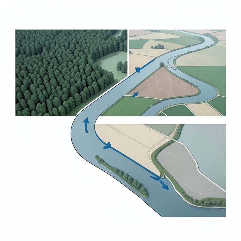
Connected Watercourse System
AI-generated conceptual illustration (A river system in the Bhagalpur region of India). It explains the idea and does not show study data.
View source evidence ↗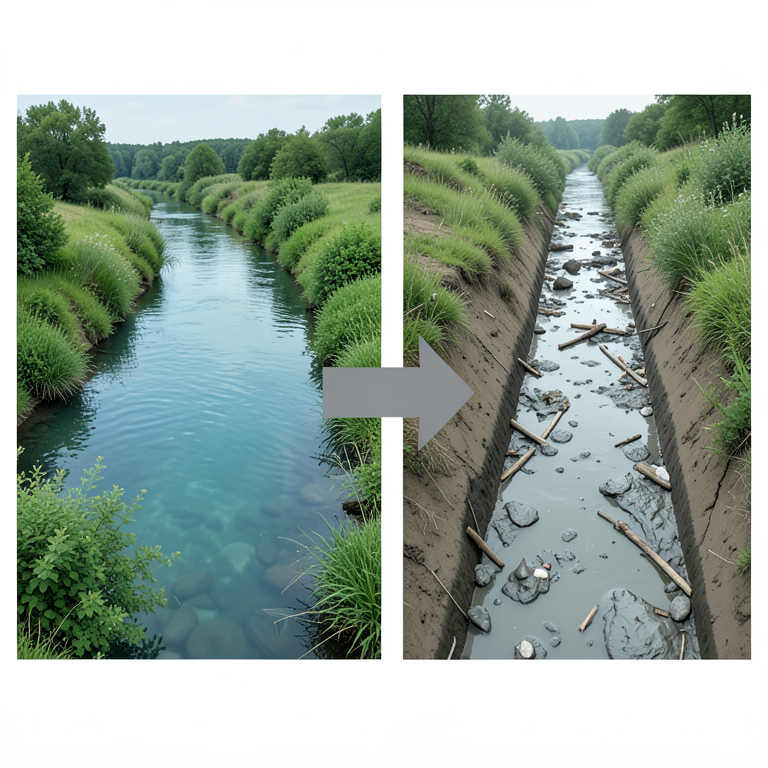
Toponymic Pejoration Cycle
AI-generated conceptual illustration (A river landscape in Bhagalpur, India). It explains the idea and does not show study data.
View source evidence ↗Figures & tables
From the original paper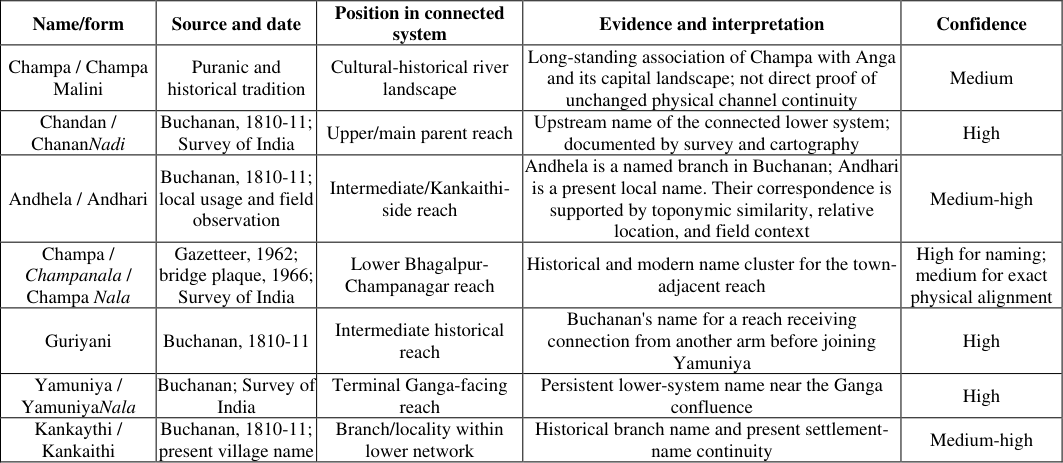 Table 1
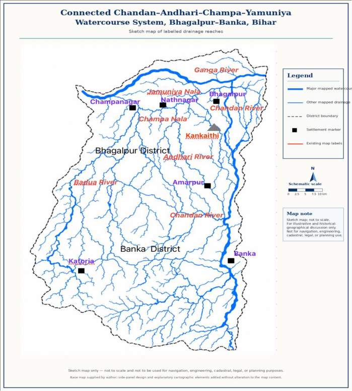 Figure 1
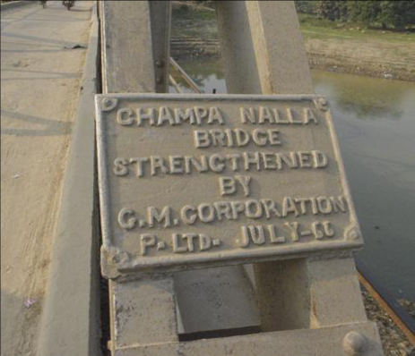 Figure 2
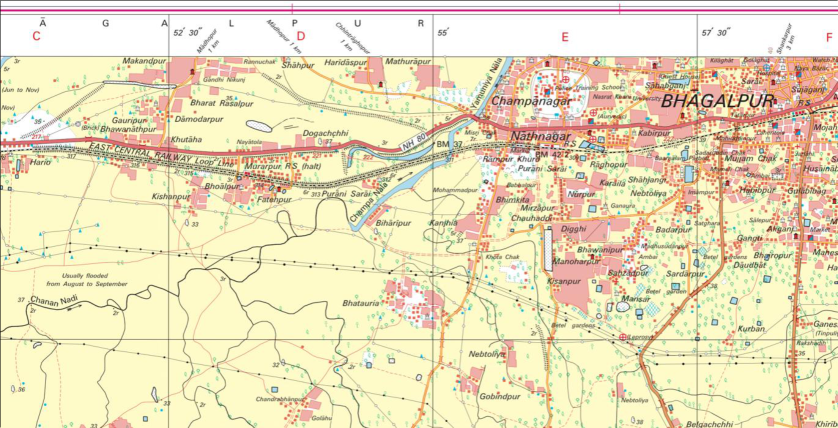 Figure 3
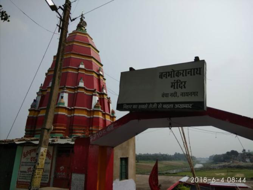 Figure 4
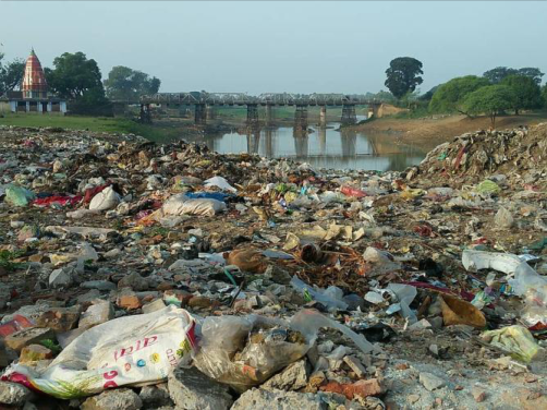 Figure 5
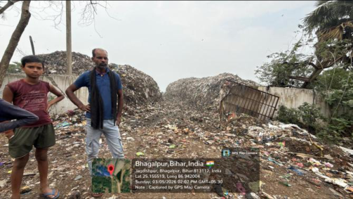 Figure 6
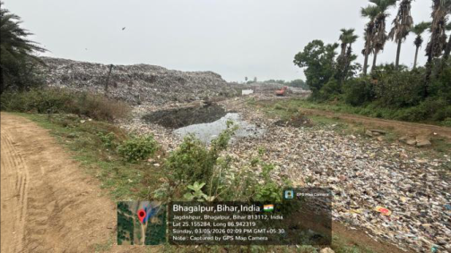 Figure 7
Introduction
Urban watercourse degradation is commonly described through pollution, solid-waste accumulation, encroachment, declining flow, habitat loss, and drainage obstruction (Silva et al., 2024; Sousa et al., 2024; Friberg et al., 2024) [12,29,30] . These material processes are fundamental to environmental analysis. Yet watercourses are also shaped by names. A hydronym influences how a channel is remembered, mapped, administratively represented, and valued in public life (Rose-Redwood et al., 2010; Azaryahu, 2011) [2,23] . When a historically known river becomes routinely described as a nala, its physical degradation may be accompanied by a less visible decline in civic and cultural recognition (Rose-Redwood et al., 2010; Shree, 2020a, 2020b) [23,25,26] . This paper examines that possibility through the Champa watercourse landscape of Bhagalpur, Bihar. For the purposes of this study, Chandan, Andhari, Champa, and Jamuniya are interpreted as reach-specific names within a single, connected watercourse, rather than as wholly separate rivers. The watercourse changes name across localities; it is known upstream as Chandan Nadi, birfurcates in Banka at Birma village, one branch continues as Chandan while the left distributary branch is called Andhari which further up north in Champanagar area is called Champa Nala, and near its lower confluence with the Ganga as JamuniyaNala. This interpretation is supported by Buchanan's early nineteenth-century account of named and renamed branches (Buchanan, 1939) [7] , the 1962 Gazetteer (Roy Chaudhury, 1962) [24] , the Survey of India sheet (Survey of India, 2009), local toponymic continuity, and GPSreferenced field observation.
Because the system is a distributary, seasonally variable, and geomorphically dynamic, the exact alignment and continuity of every reach has been further tested through GIS reconstruction and monsoon-season survey. Champa is associated in textual and historical tradition with ancient Anga and its capital, remembered as Malini and, in Puranic tradition, as Champa Malini (Roy Chaudhury, 1962, p. 36-37; Matsya Purana, as cited in Roy Chaudhury, 1962) [16, 24] . Later documentary sources reveal a changed hydrographic vocabulary. Francis Buchanan's 1810-11 survey described the lower Chandan system through several named branches Andhela, Guriyani, Kankaythi, Pangjarmara, and Yamuniya (Buchanan, 1939) [7] . By the twentieth century, the Bihar District Gazetteer used "Champanala" (Roy Chaudhury, 1962) [24] , a bridge plaque recorded "Champa Nalla" by July 1966 (Champa Nalla Bridge plaque, 1966), and the Survey of India later mapped lower reaches as "Champa Nala" and "Yamuniya Nala," while retaining "ChananNadi" upstream (Survey of India, 2009). This paper examines how the changing language of water shaped the public and administrative visibility of the Champa system. It does not treat the shift from nadi to nala as a single or sufficient cause of channel degradation, pollution, or the municipal decision to dispose off waste at Kankaithi. Rather, it argues that the normalisation of nala may have weakened recognition of the river as a historically significant watercourse. This altered perception may have formed one cultural and administrative condition through which neglect became easier to normalise, alongside more direct drivers including altered flow, sedimentation, settlement growth, wastewater discharge, waste disposal, drainage engineering, and institutional fragmentation. The study asks five questions: 1. How did the naming and representation of the lower Chandan i.e.Andhri Champa Jamuniya system change between the early nineteenth century and the present? 2. What forms of continuity can be identified among historical hydronyms, modern place-names, and present channel alignments? 3. How may nala terminology shape public and institutional perceptions of historically significant watercourses? 4. How did civic organisations, regional journalism, and public scholarship respond to the Champa's decline before and after the Kankaithi dumpsite was selected?
Conceptual framework: Hydronymy and toponymic pejoration
In Hindi-Urdu and related north Indian vernacular contexts, nadi and nala have historically possessed broad and partly overlapping geographical usages, even though they carry different associations of scale, permanence, social standing and civic importance.In contemporary urban usage, nala frequently evokes an open drain, wastewater channel, or sewer-like drainage line. This modern association can reshape the social status of named watercourses even where earlier usage included natural channels, seasonal streams, ravines, or drainage lines (McGregor, 1993; Platts, 1884; Turner, 1966) [17,20,32] . The paired expression nadi-nala can operate colloquially as an inclusive reference to watercourses of different sizes and forms. It should not be assumed, however, that the terms are interchangeable in every historical or administrative setting.
The analytical problem arises when a historically connected watercourse is known mainly through the narrowed urban sense of nala. This paper uses the term toponymic pejoration for a simple process, a place-name begins to carry a lower or more negative social meaning than it originally had. A name that once referred neutrally to a locality, channel, or landscape may become associated with dirt, waste, neglect, danger, or failure. In the present case, the proper name Champa has not become an insult. Rather, the generic term attached to it nala has acquired strongly degraded associations in contemporary urban speech. When a historically significant watercourse is known primarily as "Champa Nala," people may see it first as a drain and only rarely as part of a larger river system with ecological and historical value.
The term is used in a limited sense. It does not mean that a name alone caused pollution, dumping, or channel degradation. Nor does it imply that every watercourse called a nala was once a significant river. It identifies a potential governance problem, that once a channel is understood mainly as a drain, it may be easier to overlook its floodplain function, ecological connection, historical identity, and claim to protection.
Sources, evidence categories, and methods
The study adopts a historical-geographical and field-based approach using several distinct categories of evidence. These categories are deliberately separated to avoid treating community testimony, advocacy material, news reporting, official records, and field observation as interchangeable.
Historical and cartographic sources
Textual and historical sources concerning Champa, Anga, Champa Malini, and the cultural geography of Bhagalpur are used as evidence of cultural and historical memory. They are not used as proof that a physically unchanged river channel has persisted across millennia. This distinction matters because the alluvial Ganga plain is geomorphically dynamic and channels may migrate, bifurcate, silt, flood, or be altered by human works. Francis Buchanan's early nineteenth-century survey is used as a documentary hydrographic baseline. Buchanan recorded the Chandan and lower branches individually and described their downstream relations with the Ganga. His account is interpreted alongside the Bihar District Gazetteers: Bhagalpur (Roy Chaudhury, 1962) [24] , the 1966 Champa Nalla Bridge plaque, the Survey of India sheet G45O16/72K16 (Survey of India, 2009), and later official river-atlas material.
Field observation
GPS-referenced field verification was conducted at the Kankaithi dumpsite complex. Field records include the date of observation, georeferenced locations, photographs, and site notes documenting mixed municipal waste, standing water within a channel depression, waste immediately beside the watercourse, plastic accumulation, large waste heaps, nearby settlement land, and surrounding agricultural/vegetated land. The field evidence is observational and does not constitute laboratory analysis of water, sediment, groundwater, leachate, or air quality.
Civic-organisation documentation
The study uses organisational documentation supplied by [25,26,27,28] .
Champa in historical and cultural memory
The historical importance of Champa is embedded in a broad textual tradition linking the riverine landscape of Bhagalpur with Anga. The Atharvaveda mentions the Angas (Atharvaveda, Book V, Hymn 22, Verse 14) [1] , while Puranic genealogical traditions connect Anga with the wider political geography of eastern India (Mozumdar & Pusalker, 1951) [18] . The Bihar District Gazetteer states that Anga was "separated from Magadha by the river Champa" and identifies its capital as Malini, also called Champa Malini in the Puranas (Roy Chaudhury, 1962) [24] . The Mahabharata associates Champa with pilgrimage geography and the Anga royal tradition (Mahabharata, Vana Parva, Chapter 85; Anusasana Parva, Chapter 42). Buddhist and Jaina narratives further place Champa within important urban and religious landscapes of northern India. Chinese pilgrim accounts, read through standard translations and later historical studies, reinforce Champa's place in the regional memory of settlement, trade, religious activity, and cultivated land (Beal, 1884; Legge, 1886; Cunningham, 1924; Basham, 1954) [3,4,9,13] . These sources do not form one uniform historical record. They differ in chronology, genre, transmission, religious orientation, and purpose. Their relevance here is narrower; they preserve Champa as a culturally significant riverine and urban landscape.
Buchanan's hydrography and the lower Chandan system
Francis Buchanan surveyed the district of Bhagalpur for the East India Company in 1810-11. His account is particularly important because it records the lower Chandan system before the later administrative consolidation of local channels into the generalised label "Champa Nala." Buchanan's approach was hydrographic and topographic, he named channels, described bifurcations, and traced drainage relations toward the Ganga (Buchanan, 1939) [7] . Near Jathaurnath, Buchanan recorded the Chandan dividing into two branches. The larger branch, Andhela, travelled north-westward, received a small channel from the other arm, changed its name to Guriyani, and later joined the Ganga arm called Yamuniya. The smaller branch retained the Chandan name briefly before dividing into Kankaythi and Pangjarmara, which were themselves subject to further division and seasonal disappearance into low-lying flood landscapes (Buchanan, 1939) [7] .
Read together with later place-names and maps, Buchanan's account supports a reach-name interpretation of the system. The watercourse is not best understood as a group of wholly unrelated rivers; rather, it is a connected and branching lower drainage network whose name changes along its course. In the present study, the system is reconstructed as Chandan → Andhari → Champa/Champa Nala → Jamuniya/YamuniyaNala → Ganga. "Andhari" is used locally around Kankaithi and is interpreted as a likely modern continuation or cognate of Buchanan's Andhela; "Champa" is the historically significant lower Bhagalpur reach; and "Yamuniya" is the Ganga-facing terminal name preserved both by Buchanan and the Survey of India (Buchanan, 1939; Survey of India, 2009) [7] . The reconstruction has been carried out through historically grounded network interpretationverified through remote sensing and ground truthin, keeping in mind the limitations of a dynamic floodplain where channels migrate, divide, silt, or reconnect over time. Buchanan did not use "Champa" as the operative hydrographic name for these lower branches. He documented a network of distinct channels and local hydronyms. This cautions against projecting a single modern "Champa River" line backward onto his network. At the same time, the survival of names resembling Andhela/Andhari and Kankaythi/Kankaithi suggests that elements of earlier nomenclature may persist in transformed form in the present landscape (Buchanan, 1939).Buchanan also recorded the Baruya, later associated with Badua/Barua usage, as contributing through a related lower network. The picture that emerges is not of an isolated drain but of a distributary and confluence landscape in which hill streams, seasonal channels, flood depressions, stream branches and off-shoots, and the Ganga were historically interconnected (Buchanan, 1939) [7] .
6. The 1962 Gazetteer, the 1966 plaque, and cartographic normalisation P. C. Roy Chaudhury's Bihar District Gazetteers: Bhagalpur (1962) provides a crucial mid-twentieth-century documentary record of "Champanala." In its account of district rivers, the Gazetteer states: "One branch of the Chandan pours its water into the Ganga at Champanagar (Champanala), two miles west of the town Bhagalpur" (Roy Chaudhury, 1962, p. 4). This confirms that "Champanala" was a branch of Chandan entering the Ganga.The same volume records that Anga was "separated from Magadha by the river Champa" and identifies the capital as Malini, also called Champa Malini in the Puranas (Roy Chaudhury, 1962, p. 36). These passages show that historical river memory and modern nala nomenclature coexisted within the same official publication. The Gazetteer thus preserves a revealing duality, Champa appears as a river of historical geography, while "Champanala" appears as the accepted modern name of its lower, town-adjacent reach.
A bridge plaque provides a further item of material evidence. The plaque documents public-infrastructure use of "Champa Nalla" by July 1966. It also indicates, the bridge was in operation for a while requiring strengthening in 1966. It also shows that the Nallaterminology had become visible in an engineering and public-works context. Local accounts also identify domestic sewage, plastic waste, styrofoam, expanded-polystyrene packaging, wastewater discharge from dyeing and processing units in the Champanagar silk cluster as concerns affecting the corridor. These pressures have contributed to declining water quality, reduced channel conveyance, and waste retention in lowflow reaches. Civic efforts to recover the Champa's river identity should be viewed against this background. The evidence does not show that the term nala alone enabled waste disposal; rather, it shows that the channel came to be associated with waste, sewage, effluent concerns, and drainage obstruction even while it retained a historically and locally recognized riverine identity. The Champa corridor also faced other reported pressures.
Local accounts identify discharge from dyeing and processing units in the Champanagar silk cluster, domestic sewage, plastic waste, and single-use packaging including thermocol/styrofoam as major concerns. These materials may have contributed to water-quality deterioration, reduced channel conveyance, andaccumulation of waste in low-flow reaches. The present study does not measure industrial effluent composition, sewage load, microplastic concentration, or hydraulic obstruction. It therefore treats these as plausible and widely reported pressure pathways requiring systematic testing through water-quality sampling, drain-outfall mapping, industrialdischarge audits, and seasonal channel surveys. The importance of this pre-Kankaithi phase is conceptual as well as environmental. A watercourse widely perceived as a nala may be treated as a receiving line for waste, sewage, and industrial discharge, even where it retains historical connection to a larger river system. The evidence does not show that nomenclature alone enabled these practices. It does show that civic mobilisation to recover the Champa's identity emerged in response to a landscape where waste, effluent, sewage, and drainage obstruction had become closely associated with the channel.
Public Media Campaigns and Environmental Advocacy for the Champa
In November 2019, the Bhagalpur edition of Dainik Jagran began the community-oriented series "Kahan Gum Ho Gayi Champa?" ("Where Has Champa Disappeared?"). The campaign title is itself significant, as it foregrounded Champa as a river whose presence and memory required recovery, rather than treating the channel solely through the language of nala. The series brought together local testimony, historical references, field observations, and public discussion concerning the river's changing condition (Shukla, 2019) [28] . The first author conducted and recorded a semi-structured key-informant interview with a senior journalist associated with the initiation of the campaign. The participant provided informed consent for the interview to be used in this study.
The interview offered contextual evidence on the campaign's origin, editorial rationale, field-reporting process, and public response. Information already available in the published Dainik Jagran series is cited to the relevant newspaper articles; the interview is used only to provide unpublished editorial context and clarification.
The public documentation of the Champa's decline was further extended through a three-part SANDRP blog series published in April 2020. The posts addressed the transformation of Champa from nadi to nala, its historical association with Anga and Champanagar, and possible directions for river rejuvenation (Shree, 2020a, 2020b, 2020c) [25,26,27] . Together, Peepal The Resilience Lab's activities in 2017-20, the Dainik Jagran campaign in 2019, and the SANDRP blog series demonstrate a sustained civic effort to restore the Champa's visibility as a river. These initiatives show that concerns about declining flow, pollution, waste accumulation, cultural memory, and administrative marginalisation had become matters of organised public concern before the current legacy-waste remediation agenda.Newspaper campaigns and environmental blogs serve as important public archives of river memory, local observation, and restoration priorities, identifying issues that require further hydrological, ecological, and governance investigation.
The Kankaithi
The Kankaithi
Field setting and observations
The Kankaithi-Andhari site is located in Jagdishpur, Bhagalpur district, Bihar, where the municipal dumpsite lies beside a seasonally water-bearing channel depression locally identified as part of the Andhari offshoot system. Field observation documented substantial accumulations of open mixed-waste with limited visible separation between waste and the water-bearing channel raising concern about channel-side waste. The adjacent channel has been identified through satellite data and Google Earth as an offshoot of AndhariNadi.The waste boundary was effectively contiguous with the channel, with no meaningful vegetated or engineered riparian buffer separating major waste heaps from the channel margin. Observed conditions included extensive mounds of mixed refuse, scattered plastic, standing water, waste within the drainage corridor, an excavator engaged in waste handling or redistribution, nearby vegetation, village-side land, and agricultural land in close proximity. The observed setting is consistent with an open dumping landscape rather than an engineered sanitary landfill. Within the photographed field area, no lined containment cells, covered waste storage, visible source segregation, materialrecovery facility, or protective channel setback was evident. These findings describe observable site conditions. Kankaithi village is immediately adjacent to the dumpingground complex. Villagers reported foul odour associated with waste heaps. Agricultural land and tree-dominated vegetation occur close to the site. The apparent obstruction or constriction of the Andhari offshoot channel raises concerns for drainage conveyance, seasonal waterlogging, flood interaction, and downstream transport of plastic and other waste.
Legacy-waste remediation and proposed processing
The Kankaithi land is reported to be owned by the The historical-geographical record examined in this paper reveals that the transformation of the lower Chandan-linked landscape has been shaped by multiple, interacting processes. These include geomorphic change, seasonality, settlement growth, road and rail infrastructure, drainage modification, industrial and domestic wastewater, urban waste generation, and institutional fragmentation. This paper does not support a simplistic claim that a formerly pristine river became a drain only because of a change in name. Naming is one strand within this wider socioecological history.The central hydrological implication is that Chandan, Andhari, Champa, and Jamuniya should not be treated as separate or unrelated drainage features. Rather, they are reach-specific names within a single, connected watercourse system that is branching and seasonally variable. The differentiation of names across the system may also have encouraged fragmented administrative attention, the upstream Chandan is more readily recognised as a nadi, whereas the town-side Champa and terminal Jamuniya are represented as nalas, and the Andhari reach near Kankaithi has largely ceased to be recognised as part of a river system. A system-level approach is therefore essential for restoration, flood management, water-quality monitoring, and waste-siting decisions. The chronology of civic engagement is broader than a single campaign. Peepal The Resilience Lab mobilised public participation in 2017-18; Dainik Jagran made the river's disappearance a public community issue in 2019; and the SANDRP essays connected the Champa case to wider debates on river ecology and rejuvenation (Peepal The Resilience Lab, 2017-2018; Shukla, 2019; Shree, 2020a, 2020b, 2020c) [25,26,27,28] . These initiatives show that local civil society, regional journalism, and environmental advocacy writingsrecognised the Champa as an endangered watercourse. This chronology strengthens the case for restoration that addresses not only present waste infrastructure but also the longer history of waste, sewage, reported industrial effluent, channel obstruction, and declining public recognition in the Champa corridor.
Conclusion
The movement from Champa and Champa Malini in the cultural geography of Anga to "Champa Nala" on modern maps is neither solely a story of linguistic change nor solely one of physical degradation. It is a historical process in which changing hydronyms, administrative representation, reduced ecological visibility, civic mobilisation, and material neglect have become intertwined. The documentary record traces a meaningful transition: from a historically remembered riverine landscape and a differentiated network of named channels to public-infrastructure inscription and official cartographic representation in the language of nala. This process may be understood as toponymic pejoration, the gradual lowering of a watercourse's perceived status when the generic term attached to its name acquires degrading urban associations. In the Champa case, the issue is not that the word nala independently caused the dumpsite, sewage discharge, or ecological decline. Rather, its normalisation may have weakened the river's public, cultural, and administrative standing, making it easier for the lower channel to be treated as marginal drainage infrastructure rather than as part of a connected river system. The restoration of Champa therefore requires both material intervention and representational recovery, protection of flows and channels, control of waste and pollution, and renewed recognition of the watercourse's historical and ecological identity. The establishment of the Kankaithi dumpsite beside the Andhari watercourse appears to have shifted, rather than resolved, the geography of municipal waste disposal. Earlier, garbage dumping along the banks and bed of the Champa at Champanagar was highly visible to residents and travellers using the main urban transport corridors. The transfer of disposal activity to Kankaithi moved this burden to an upstream reach of the Champa-linked system, at a location comparatively removed from the principal transport network and therefore less immediately visible to the wider public. This shift presents both a warning and an opportunity. Legacy-waste biomining and any future CBG facility can contribute to a transition away from passive dumping only if they are accompanied by rigorous channel protection, transparent monitoring, pollution assessment, source segregation, community participation, and recognition of the Andhari as a water body within a historically connected drainage landscape.
Recovering the Champa's historical memory is not merely antiquarian, it is a practical step toward restoring a watercourse that remains part of Bhagalpur's environmental infrastructure and cultural geography. The historical-geographical reconstruction developed in this paper indicates that Chandan, Andhari, Champa, and Yamuniya should not be managed as separate or unrelated features. Rather, they are reach-specific names within a connected lower drainage system that ultimately joins the Ganga, notwithstanding the branching, migration, and transformation of individual channels over time. This system-level perspective is essential for effective governance. Waste accumulation or channel obstruction in the Andhari-Kankaithi reach should not be treated solely as a local drainage concern, because its hydrological and ecological implications may extend through the wider Champa-Yamuniya corridor.
Figures and tables from the paper
References
29 in the original paper- Azaryahu M. The critical turn and beyond: the case of commemorative street naming. ACME An Int J Crit Geogr. 2011;10(1):28-33.
- Basham AL. The wonder that was India. London: Sidgwick & Jackson; 1954.
- Beal S, translator. Buddhist records of the Western world. Vol. 2. London: Trübner; 1884.
- Bhagalpur Index. Hindustan Petroleum Corporation Limited will set up a compressed-biogas plant at Kankaithi dumping ground, Bhagalpur. Public project announcement. 2025 Aug 20. Available from: https://x.com/BhagalpurIndex/status/195803221066718 8655
- Bhagalpur Municipal Corporation. Request for proposal for bio-remediation/bio-mining of legacy waste at Kankaithi dumpsite, Bhagalpur. Tender notice. [cited 2026 Sep 18]. Available from: https://www.tenderdetail.com/IndianTenders/TenderNotice/49013520/c1e7dc9103147c1b63 e64ecb351528bc
- Buchanan F. An account of the district of Bhagalpur in 1810-11. Patna: Bihar and Orissa Research Society; 1939. Reprint.
- Champa Nalla Bridge plaque. Inscription: "CHAMPA NALLA BRIDGE / STRENGTHENED / BY / G.M. CORPORATION / P. LTD. JULY-66." Bhagalpur; 1966. Photograph supplied by the authors.
- Cunningham A. The ancient geography of India. Edited by Mozumdar SN. Calcutta; 1924.
- Dainik Jagran. Bhagalpur: plan for boundary wall at Kankaithi dumping ground after departmental approval. 2018 Sep 27. Available from: https://www.jagran.com/bihar/bhagalpur-kankaithidumping-ground-will-be-siege-18472185.html
- Dainik Jagran. Bhagalpur: ₹139 crore compressedbiogas plant proposed at Kankaithi dumping ground; 10 acres approved for HPCL. 2026 Aug 13. Available from: https://www.jagran.com/bihar/bhagalpurbhagalpur-kankathi-biogas-plant-139-crore-hpclproject-approved-40338731.html
- Friberg N, et al. Impacts of diffuse urban stressors on stream benthic communities and ecosystem functioning: a review. Limnetica. 2024;43(1):89-108. DOI:10.23818/limn.43.07.
- Legge J, translator. A record of Buddhistic kingdoms: being an account by the Chinese monk Fa-Hien of his travels in India and Ceylon. Oxford: Clarendon Press; 1886.
- Live Hindustan. Deputy mayor inspected the land selected for the Kankaithi dumping ground. 2018 Jan 8. Available from: https://www.livehindustan.com/bihar/bhagalpur/storydeputy-mayor-inspected-the-dumping-ground-site1736991.html
- Matsya Purana. Reference to Champa Malini. In: Roy Chaudhury PC. Bihar district gazetteers: Bhagalpur. Patna: Superintendent, Secretariat Press; 1962. [Reference as cited in source].
- McGregor RS. The Oxford Hindi-English dictionary. Oxford: Oxford University Press; 1993.
- Mozumdar RC, Pusalker AD, editors. The Vedic age. London: George Allen & Unwin; 1951. 19. Peepal The Resilience Lab. Organisational documentation on Champa river-bank meetings, catchment engagement, and the "Run for Revival of River Champa," November 2017-April 2018. 20172018. Available from: http://ptrl.org/initiatives/
- Platts JT. A dictionary of Urdu, classical Hindi, and English. London: W. H. Allen; 1884.
- Prabhat Khabar. Compressed-biogas plant proposed on 10 acres at Kankaithi under HPCL initiative. 2026 Aug 19. Available from: https://www.prabhatkhabar.com/state/bihar/bhagalpur/b hagalpur-news-gas-will-be-made-from-garbage-inbhagalpur-cbg-plant-to-be-set-up-on-10-acres-no-costto-municipal-corporation
- Press Information Bureau, Government of India. India's drive to eliminate city dumpsites under Swachh Bharat Mission-Urban. 2025. Available from: https://www.pib.gov.in/PressReleaseDetail.aspx?PRID =2221171
- Rose-Redwood R, Alderman D, Azaryahu M. Geographies of toponymic inscription: new directions in critical place-name studies. Prog Hum Geogr. 2010;34(4):453-470. DOI:10.1177/0309132509351042.
- Roy Chaudhury PC. Bihar district gazetteers: Bhagalpur. Patna: Superintendent, Secretariat Press; 1962.
- Shree R. How did Champa Nadi (river in Bhagalpur, Bihar) become Nala (drain)? South Asia Network on Dams, Rivers and People. 2020 Apr 5. Available from: https://sandrp.in/2020/04/05/how-did-champa-nadiriver-in-bhagalpur-bihar-become-nala-drain/
- Shree R. Champa's Angpradesh to Champa Nala of Bhagalpur. South Asia Network on Dams, Rivers and People. 2020 Apr 12. Available from: https://sandrp.in/2020/04/12/champas-angpradesh-tochampa-nala-of-bhagalpur/
- Shree R. Bringing life back to Champa River. South Asia Network on Dams, Rivers and People. 2020 Apr 22. Available from: https://sandrp.in/2020/04/22/bringing-life-back-tochampa-river/
- Shukla D, editor. Kahan gum ho gayi Champa? Community-investigation series by Ashwini and others. Dainik Jagran, Bhagalpur edition. 2019 Nov-Dec.
- Silva CF, Pereira EA, Carvalho MD, et al. Urban river recovery: a systematic review on the effectiveness of water clean-up programs. Environ Sci Pollut Res. 2024;31:26355-26377. DOI:10.1007/s11356-02433055-w.
- Sousa MC, Martins R, Simões NE, Feio MJ. Ecosystem services of urban rivers: a systematic review. Environ Sci Pollut Res. 2024.
- Turner RL. A comparative dictionary of the Indo-Aryan languages. London: Oxford University Press; 1966. Personal communication cited in text only
- Ashwini Kumar Singh, Deputy State Editor, DainikJagaran Bihar. Personal communication as Key Informant Interview (KII) with Rani Sahay, September 12, 2025.