
Research article · 2026 · Full text
International Journal of Geography Geology and EnvironmentIntegrating GIS and AHP for optimal landfill site selection: A case study of Sikar city, India
Volume 8(5) · Pages 47–48 · DOI: 10.22271/27067483.2026.v8.i5a.753 ↗
Research areasMunicipal Solid Waste ManagementMulti-Criteria Decision MakingSoil and Land Suitability Analysis
Abstract
Author-writtenMunicipal solid waste management (MSWM) has emerged as a major concern both globally and locally, with landfill site selection being a crucial aspect. In many Indian cities, including Sikar, existing dumping sites were chosen based on land availability rather than actual suitability. This study applied Geographic Information Systems (GIS) and multi-criteria decision analysis (MCDA) through the Analytical Hierarchy Process (AHP) to categorize city areas into three suitability classes most suitable, suitable, and unsuitable for landfill development. Results showed that 87.23 percentage were unsuitable, while 10.98 percentage were suitable, and only 1.75 percentage fell into the most suitable category. Out of 12 potential locations identified, only 6 met the minimum requirement of 20 hectares and complied with the Sikar City Master Plan 2031. The analysis also found that the current landfill sites in a moderately suitable zone. This research contributes to the body of knowledge on scientifically and socially acceptable landfill site selection in developing countries by integrating MCDA, AHP, and GIS methods to enhance environmental and socioeconomic sustainability, aligning with Sustainable Development Goals (SDGs) 3, 6, and 11.
Summary
Source-checkedPlain-language reading of the full paper, prepared with AI and checked against the text. Each point links to the authors' own words.
Why it matters
- Municipal solid waste management is a significant global and local concern, making the selection of appropriate landfill sites a critical task. View evidence ↗
- In Sikar and other Indian cities, landfill sites have historically been chosen based on land availability instead of scientific suitability. View evidence ↗
- Sikar's current landfill is poorly located in a densely populated western area near water, where prevailing winds carry unpleasant odors into the city. View evidence ↗
The question
- The study aims to use Multi-Criteria Decision Analysis (MCDA) and Geographic Information Systems (GIS) to evaluate and identify sustainable landfill locations in Sikar City. View evidence ↗
What they did
- The researchers analyzed ten different map layers, including topography, infrastructure, land use, and water sources, to determine site suitability. View evidence ↗
- Data was gathered from Sentinel 2A imagery (10m resolution), OpenStreetMap, and SRTM digital elevation data (30m resolution). View evidence ↗
- The study utilized the Analytical Hierarchy Process (AHP) to weight criteria and the Weighted Linear Combination (WLC) method to create the final suitability map. View evidence ↗
What they found
- Initial categorization of city areas showed that 87.23% were unsuitable, 10.98% were suitable, and only 1.75% were most suitable for landfills. View evidence ↗
- Most of the region was found to be highly suitable regarding distance from water bodies (98.7%) and slope (89.756%). View evidence ↗
- The final integrated suitability analysis determined that 88.73% of the area is unsuitable, 5.05% is appropriate, and 6.21% is highly suitable. View evidence ↗
- Of the 12 potential sites identified, only 6 met the minimum size requirement of 20 hectares and aligned with the city's 2031 Master Plan. View evidence ↗
What it means
- The authors conclude that the most suitable landfill locations for 2031 are situated in the eastern and north-eastern regions of Sikar. View evidence ↗
- The authors recommend that local governments adopt GIS and MCDA methods to ensure waste management is environmentally sustainable and socially acceptable. View evidence ↗
Visual summary
3 visualsIllustrations explain the paper; charts are replotted from the paper's own table values.
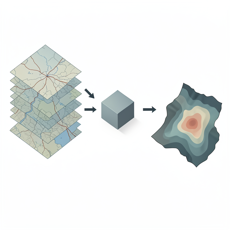
Landfill Site Selection Workflow
AI-generated conceptual illustration (A geographical landscape of Sikar city, India, represented as a series of stacked map layers). It explains the idea and does not show study data.
View source evidence ↗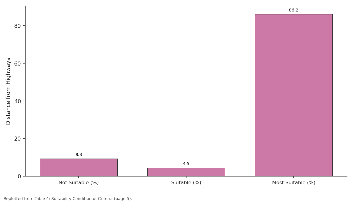
Distance from Highways: Not Suitable (%) vs Suitable (%) vs Most Suitable (%)
Replotted from Table 4 (page 5) of the original paper. Every bar is the paper's own table value.
View source evidence ↗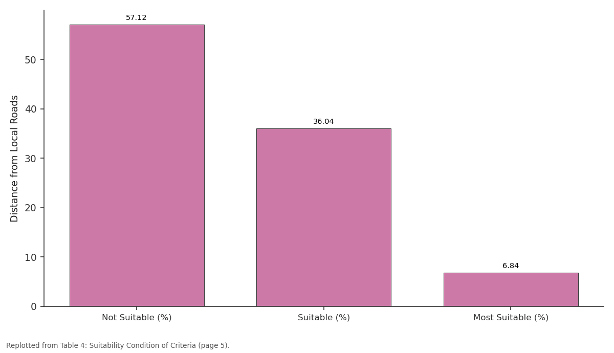
Distance from Local Roads: Not Suitable (%) vs Suitable (%) vs Most Suitable (%)
Replotted from Table 4 (page 5) of the original paper. Every bar is the paper's own table value.
View source evidence ↗Figures & tables
From the original paper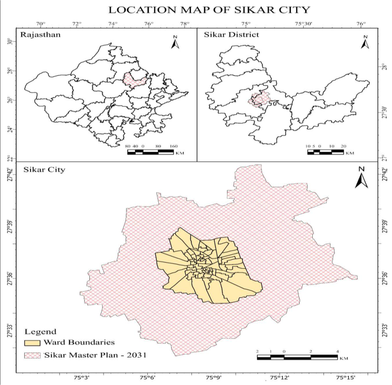 Figure 1
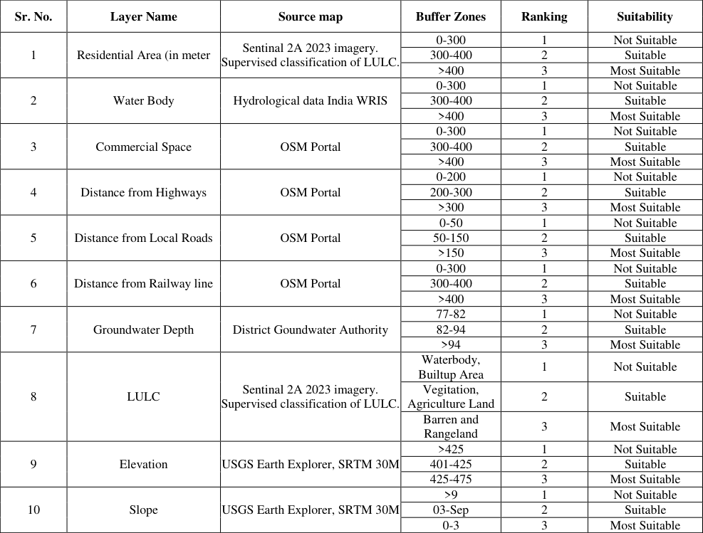 Table 1
 Table 2
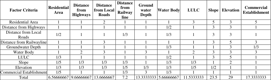 Table 3
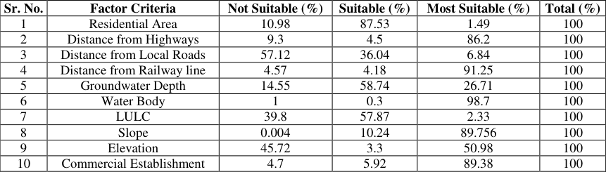 Table 4
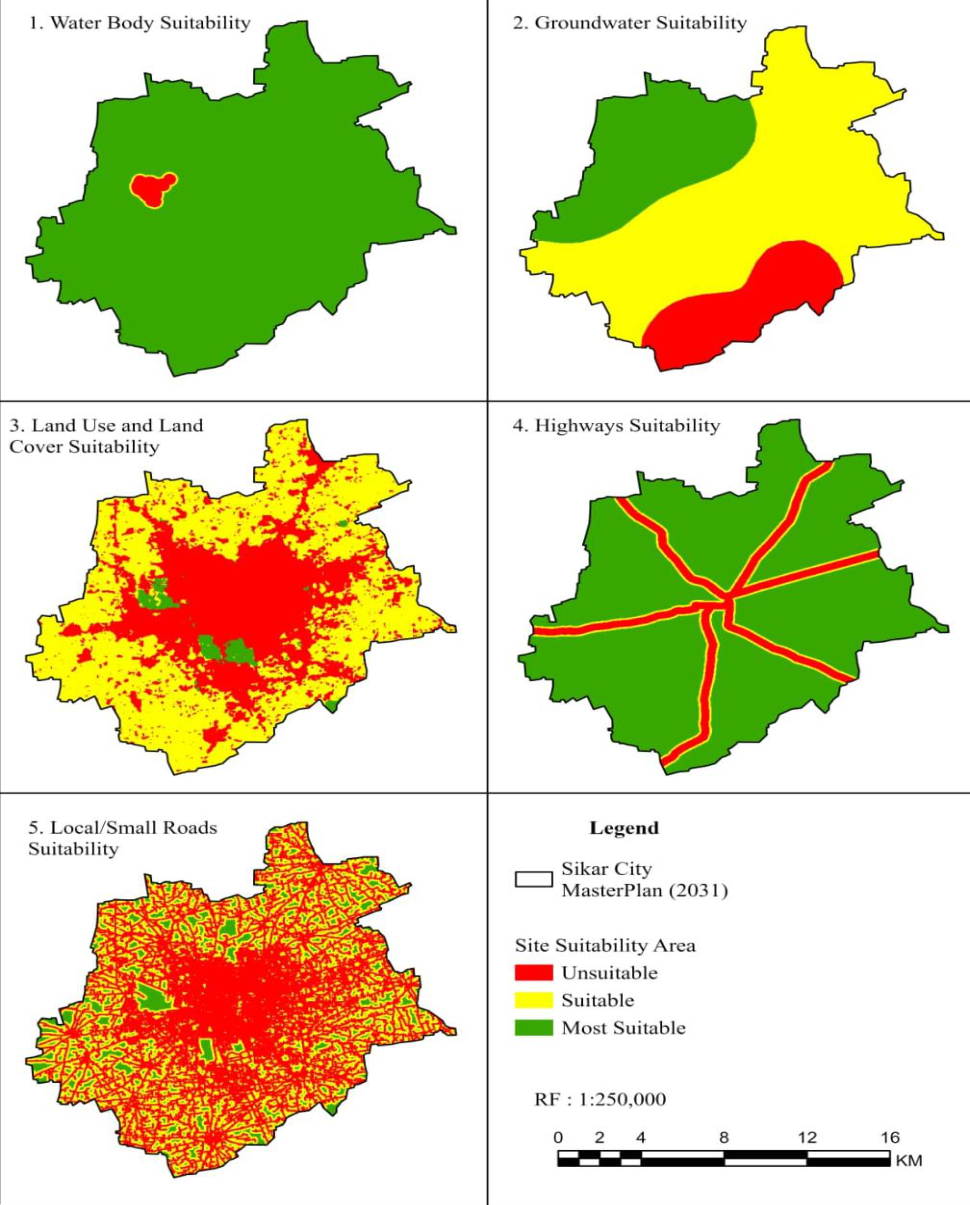 Figure 2
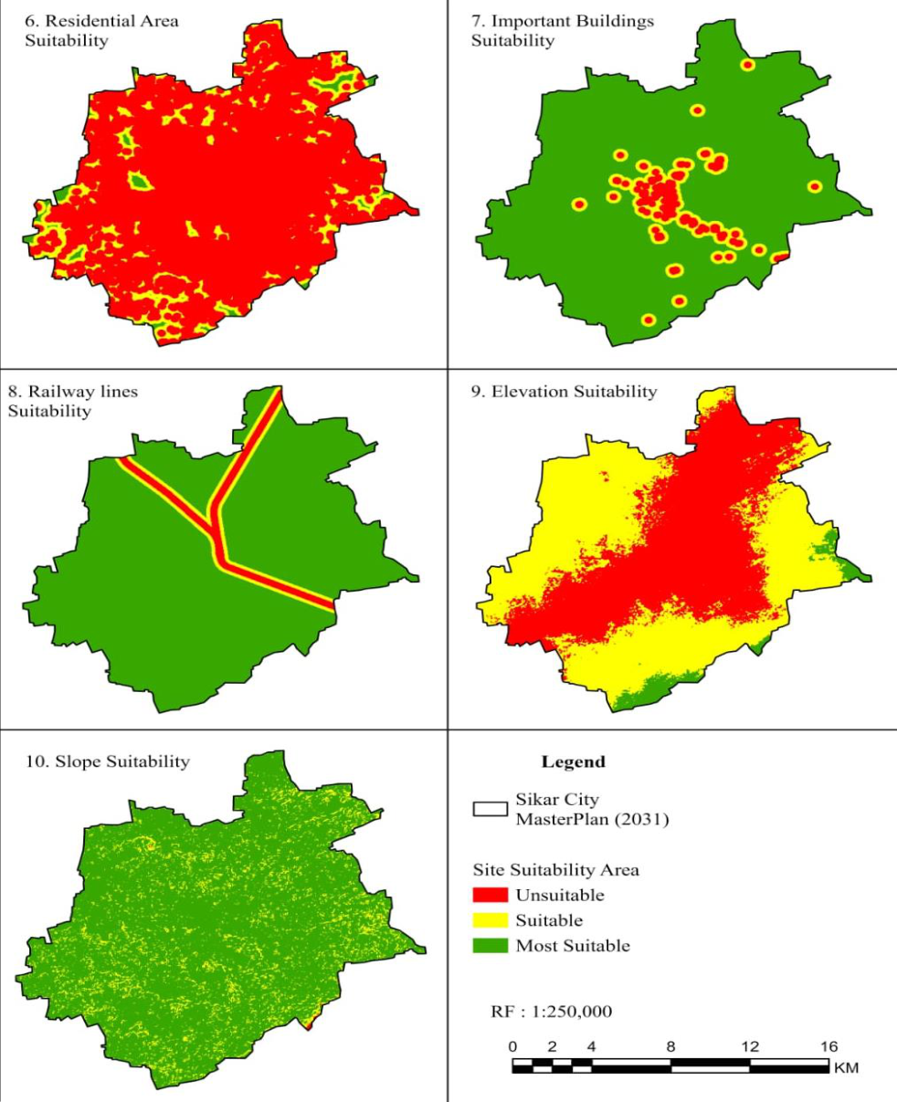 Figure 3
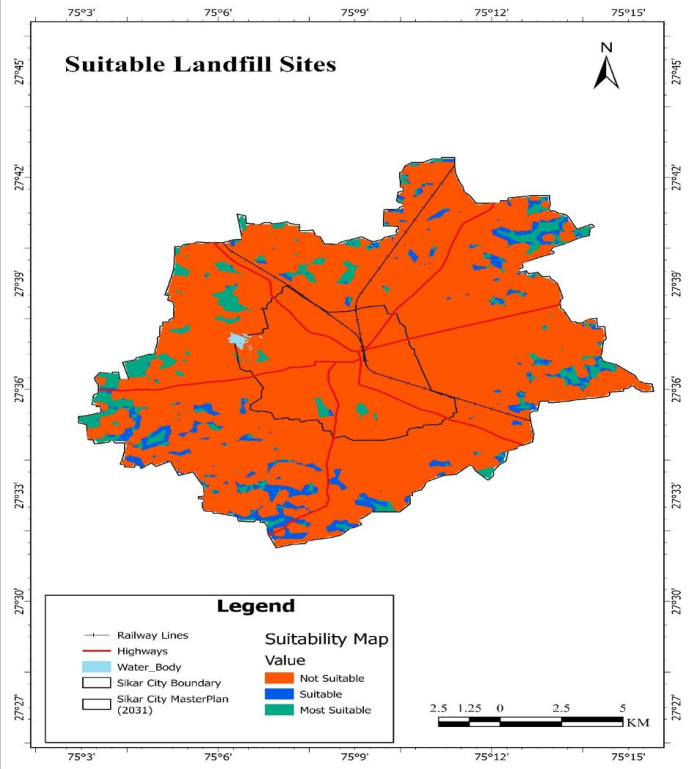 Figure 4
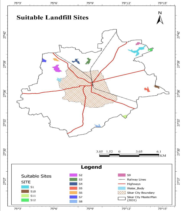 Figure 5
Introduction
The management of municipal solid waste (MSW) has become increasingly important due to the numerous obstacles that MSW presents, as well as the identification and allocation of suitable disposal sites (Gbanie et al., 2013). Consequently, it is imperative to conduct a comprehensive assessment and make well-informed decisions regarding the selection of a disposal site in order to achieve environmentally responsible and sustainable solid waste management. The optimal landfill sites can be determined by incorporating a variety of disciplines, including environmental science, hydrogeology, sociology, economics, and engineering, as demonstrated by numerous studies. In order to identify an appropriate landfill site for solid waste disposal, Kontos and Komin integrated socioeconomic and environmental variables. Kharat and colleagues (Kharat 2016) [34] identified sensitive areas and intra-municipal factors as the most significant influences. It necessitates an understanding of numerous criteria, parameters, regulations, and simultaneous evaluations (Djokanovic 2016) [21] . The issue of solid waste management in Indian cities has become increasingly intricate over the past two decades, akin to that of rapidly expanding industrial cities (Gupta, 2015) [27] . The rapid increase in municipal solid waste in Sikar City can be attributed to a variety of factors, including inadequate urban planning, insufficient capital investment in this sector, and a rapid surge in population over the past decade, particularly in the education industry that has grown in anticipation of competitive exams. The impetus for this research is the imperative need to evaluate the appropriateness of a landfill location in Sikar City by integrating MCDA and GIS, and to offer evidence-based insights for sustainable landfill site management. The generation of municipal solid waste (MSW) is increasingly recognized as a global environmental issue, significantly affecting public health, environmental deterioration, and climate change (Joshi & Ahmed, 2016) [30] . According to World Bank report "Waste 2.0" highlights that municipal solid waste generation is projected to rise from 2.1 billion tonnes annually in 2023 to 3.8 billion tonnes by 2050 (Beede & Bloom, 1995) [12] . India produces over 160,038.9 tonnes of solid trash daily, with approximately 152,749.5 tonnes collected, reflecting a collection efficiency of 95.4% (CPCB Annual Report, 2022) [17] .
The 79,956.3 TPD (50%) of the collected waste was treated, while 29,427.2 TPD (18.4%) was sent to landfills (CPCB Annual Report, 2022) [17] . Nevertheless, 31.7% of the total waste generated, or 50,655.4 TPD, remains unaccounted for (CPCB Annual Report, 2022) [17] . Various factors, including GDP development, rapid urbanisation, population growth, tourist traffic, and industrial expansion, influence the massive amount of MSW generation (Srivastava 2015) [46] Waste management systems, particularly those in developing nations worldwide, are confronted with significant challenges as a result of the substantial rise in municipal solid waste generation (Pal & Bhatia, 2022) [41] . Consequently, in order to surmount the obstacles presented by MSW, it is imperative to adhere to the principle of integrated solid waste management (ISWM). The Sikar Nagar Parishad operates a landfill facility in the city. Nevertheless, the selection of this disposal site is primarily determined by administrative convenience and land availability, rather than scientific parameters that consider environmental, social, and infrastructural factors. In the western region of the city, the landfill site is situated in a densely populated location adjacent to an aquatic body. This location is in opposition to the city's geography, as it is subject to wind for the majority of the year. The current landfill site is located in the western region of the city, in close proximity to an aquatic body. The area is densely populated. The city's geography presents a challenge in this location, as the prevailing winds from the west or southwest frequently transport odours. The site's proximity to residential neighbourhoods and aquatic bodies also poses substantial hazards to public health and environmental safety. It emits an unpleasant odour throughout the city as it flows from the west or southwest. The proximity to residential areas and water bodies also poses a significant hazard to the welfare of the public and the environment.
Description of study area
Sikar City, located in the north-eastern part of Rajasthan, India, is an important urban center and administrative headquarters of Sikar district. Geographically, it lies between 27°36′ to 27°57′ N latitude and 75°02′ to 75°25′ E longitude, covering an area of around 17 square kilometers within the municipal limits. The city is part of the semi-arid region of the Shekhawati area, known for its distinctive culture, painted havelis, and historical heritage. Sikar serves as a key educational hub in Rajasthan, often referred to as the "Education City," hosting numerous schools, colleges, and coaching institutes that attract students from across the state and beyond. Economically, the city's livelihood is supported by trade, agriculture from surrounding rural areas, and service-based industries. The climate is characterized by extreme summers, mild winters, and low to moderate annual rainfall, influenced by the arid and semi-arid conditions of the region. The city is well-connected by road and rail, linking it to major cities like Jaipur, Delhi, and Bikaner. Culturally rich, Sikar reflects a blend of traditional Rajasthani lifestyle and modern urban growth. Rapid urbanization in recent decades has led to expansion beyond its historical core, bringing challenges related to infrastructure, waste management, and sustainable development.
Material and Methods
Material and Methods
Data Collection
The analysis encompasses ten unique input map layers: elevation, slope, residential zones, local roads, highways, railway lines, land use and land cover, significant commercial areas, groundwater, and water bodies (refer to Table 1). The criteria for constraints were established in accordance with the regulations set forth by the Central Pollution Control Board (CPCB), the Rajasthan State Pollution Control Board (RSPCB), and the Municipal Solid Waste Management Rules of 2016, alongside contributions from academic specialists in pertinent areas. The criteria are designed to protect the environment, ensure public health, and address various aesthetic considerations. The criteria for constraints encompass water bodies along with a 200-meter buffer zone surrounding them, residential areas accompanied by a 200-meter buffer zone, and a 200-meter zone encircling significant commercial spaces. In the analysis of land use and land cover, residential areas and water bodies are identified as constraint criteria. Elements like water bodies, residential zones, and commercial areas function as both criteria for consideration and limitations, thus acting as dual criteria. The LULC and water body layers were derived from Sentinel 2A imagery for 2024, featuring a resolution of 10 meters, acquired from the European Space Agency. Data pertaining to highways, railway lines, and local roads were sourced from the OpenStreetMap platform. Additional datasets, including digital elevation data, were obtained from the Shuttle Radar Topography Mission (SRTM) at a resolution of 30 meters through USGS Earth Explorer. Data on groundwater levels were sourced from the district groundwater authority. All map layers were developed with ArcGIS software, and the statistical analysis of the Multi-Criteria Decision Analysis (MCDA) employing the Analytic Hierarchy Process (AHP) was performed using Microsoft Excel 2021. Every map layer adheres to a consistent reference framework that aligns with national mapping standards, namely WGS 84 and UTM 43N. A raster data model was chosen, and all input map layers, regardless of their original format as raster or vector, were either resampled or converted to a raster with a uniform grid size of 30 meters. Table 1 presents the layers, buffer zones, and rankings.
| Sr. No. | Layer Name | Source map | Buffer Zones | Ranking | Suitability |
|---|---|---|---|---|---|
| 1 | Residential Area (in meter | Sentinal 2A 2023 imagery. Supervised classification of LULC. | 0-300 | 1 | Not Suitable |
| 300-400 | 2 | Suitable | |||
| >400 | 3 | Most Suitable | |||
| 2 | Water Body | Hydrological data India WRIS | 0-300 | 1 | Not Suitable |
| 300-400 | 2 | Suitable | |||
| >400 | 3 | Most Suitable | |||
| 3 | Commercial Space | OSM Portal | 0-300 | 1 | Not Suitable |
| 300-400 | 2 | Suitable | |||
| >400 | 3 | Most Suitable | |||
| 4 | Distance from Highways | OSM Portal | 0-200 | 1 | Not Suitable |
| 200-300 | 2 | Suitable | |||
| >300 | 3 | Most Suitable | |||
| 5 | Distance from Local Roads | OSM Portal | 0-50 | 1 | Not Suitable |
| 50-150 | 2 | Suitable | |||
| >150 | 3 | Most Suitable | |||
| 6 | Distance from Railway line | OSM Portal | 0-300 | 1 | Not Suitable |
| 300-400 | 2 | Suitable | |||
| >400 | 3 | Most Suitable | |||
| 7 | Groundwater Depth | District Goundwater Authority | 77-82 | 1 | Not Suitable |
| 82-94 | 2 | Suitable | |||
| >94 | 3 | Most Suitable | |||
| 8 | LULC | Sentinal 2A 2023 imagery. Supervised classification of LULC. | Waterbody, Builtup Area | 1 | Not Suitable |
| Vegitation, Agriculture Land | 2 | Suitable | |||
| Barren and Rangeland | 3 | Most Suitable | |||
| 9 | Elevation | USGS Earth Explorer, SRTM 30M | >425 | 1 | Not Suitable |
| 401-425 | 2 | Suitable | |||
| 425-475 | 3 | Most Suitable | |||
| 10 | Slope | USGS Earth Explorer, SRTM 30M | >9 | 1 | Not Suitable |
| 03-Sep | 2 | Suitable | |||
| 0-3 | 3 | Most Suitable |
Table text extracted from the original PDF; superscript letters are shown inline. The original table image is below.
View original table image
Methods
Methods
Setting of Factor Criteria
The criteria are divided into three main categories: environmental factors (such as water bodies, LULC and groundwater), socio-economic factors (including highways, local roads, railway lines, residential areas, and commercial spaces), and topographic factors (slope, and elevation). Each factor is ranked on a scale from 1 to 3, where one indicates that the factor is unsuitable, two means suitable, and three denotes the most appropriate (see Table 1).
Water Body
Water bodies play a crucial role in determining landfill site suitability, as they are considered one of the most important factors in the selection process. This study, water bodies are critical factors in landfill site suitability analysis due to their potential vulnerability to contamination. In this study, the criteria for proximity to water body were defined as follows: 0-300 m is deemed unsuitable, 300 -400 m is considered suitable, and more than 400 m is most suitable.
Groundwater
Groundwater depth plays a crucial role in landfill site selection, as it is considered one of the most important criteria in the process. In this study, the criteria for depth of groundwater were defined as follows: 72-82 m is deemed unsuitable, 82-94 m is considered suitable, and more than 94 m is most suitable.
Land Use and Land Cover (LULC).
Land use and land cover are crucial in determining landfill site suitability. This study utilized the 2024 Sentinel 2A Satellite Imagery, which was processed through a supervised classification method using ArcGIS software, applying the maximum likelihood parametric decision rule (Saini et al., 2024) [43][44] . The classification was based on a predefined LULC classification scheme provided by ESRI, along with a field survey conducted in the study area. The framework included six distinct categories: water bodies, vegetation, built-up areas, agriculture, rangeland, and bare land. The comparative appropriateness of various land uses indicates that waterbodies and built-up areas are deemed unsuitable, whereas agricultural and vegetative land is considered suitable. Additionally, bare land and rangeland are identified as the most suitable options, as illustrated in the table.
Highways
The role of highways in selecting landfill sites is considered an important economic factor in the site selection process. Thus, highways play a significant role in landfill site selection, primarily as an economic factor influencing transportation costs and accessibility. However, their environmental impact is also considered in some studies, highlighting the complex nature of landfill site selection processes that must balance various factors to find optimal locations. In this study, the criteria for proximity to Highways were defined as follows: 0-200 m is deemed unsuitable, 200 -300 m is considered suitable, and more than 300 m is most suitable.
Local Roads
The accessibility and consistent usability of the road are essential considerations for determining the suitability of landfill sites. In this study, the criteria for proximity to local roads were established based on the feasibility of local conditions and transport costs as follows: Depths of 0-50 m are regarded as unsuitable, while those between 50 and 150 m are viewed as suitable, and depths exceeding 150 m are classified as most suitable.
Residential Area
The distance from residential areas plays a crucial role in selecting suitable landfill sites, as highlighted by multiple studies: Residential areas are consistently considered a key criterion in landfill site selection processes. Based on these considerations, the buffer distance from the residential area is as follows: <300 m is unsuitable, 200 -400 m is suitable and >400 m is most suitable.
Commercial Space
Commercial space plays a significant role in landfill site suitability assessment, as it is an important factor to consider when selecting appropriate locations for waste disposal. Commercial space is a critical factor in the suitability assessment of landfill sites. In this study the buffer distance from the commercial space is as follows: <300 m is unsuitable, 200 -400 m is suitable and >400 m is most suitable.
Railway line
Proximity to transportation routes like railway lines or highways plays a significant role in environmental impact assessments for landfill sites, influencing both economic and environmental factors. In this study, the criteria for proximity to Railway line were defined as follows: 0-300 m is deemed unsuitable, 300 -400 m is considered suitable, and more than 400 m is most suitable.
Elevation: Elevation plays a significant role in determining landfill site suitability, as highlighted in several studies: Elevation is considered an important criterion in landfill site selection due to its impact on environmental and operational factors. Lower elevations are generally preferred for landfill sites to minimize the risk of contamination to surrounding areas and water sources (Mallick, 2021; Zandi et al., 2024).
The study area is situated in flat plain area eastern most part have some undulating hills. The elevation in this region varies from 401-573 meters. Based on literature the higher elevation area above 475m is deemed unsuitable, and low laying area below 425 m is suitable and area between 425-475m is most suitable.
Slope
Slope plays a crucial role in determining landfill site suitability across multiple studies: Slope is consistently identified as one of the key criteria for landfill site selection (Elkhrachy 2023) [61] . It is considered an important factor due to its influence on various landfill construction and operation aspects. Steeper slopes are generally less suitable for landfills as they can lead to increased runoff, soil erosion, and potential instability of the landfill structure (Karimi et al., 2018) [57] . Interestingly, in the study area, slope values range from 0.01• to 34•. Areas with slopes between 0• and 3• are considered most suitable. Slopes from 3• to 6• are suitable, >9• are not suitable. Analytic Hierarchy Process: AHP, introduced by Satty in 1980, utilizes pairwise comparison to assess the relative significance of the criteria (Saaty, 1980) [58] . This approach enables the prioritization of criteria and aids in intricate decision-making by breaking down criteria into hierarchical structures that incorporate both quantitative and qualitative elements (McIntyre & Parfitt, 1998) [37] . AHP is frequently applied in studies assessing the suitability of landfill sites, typically alongside Geographic Information Systems (GIS) and various multi-criteria decision-making approaches. The AHP methodology facilitates the allocation of weights to different criteria involved in the selection of landfill sites, enabling a structured and impartial assessment of prospective locations.
According to Saaty and Vargas in (Saaty & Vargas, 2012) [42] , the consistency ratio (CR) for pairwise comparisons should be below 10%. The Consistency Index (CI) was calculated using the following formula:
In this context, n represents the total number of criteria, while λmax signifies the average eigenvalue of the judgment matrix. A lower Consistency Index (CI) signifies enhanced consistency within the pairwise comparison matrix. The Consistency Ratio (CR) is calculated by dividing the Consistency Index (CI) by the Random Consistency Index (RI) corresponding to the specified value of n, as demonstrated in Table 3.
| Factor Criteria | Residential Area | Distance from Highways | Distance from Local Roads | Distance from Railway line | Ground water Depth | Water Body | LULC | Slope | Elevation | Commercial Establishment |
|---|---|---|---|---|---|---|---|---|---|---|
| Residential Area | 1 | 1 | 2 | 1 | 1 | 1 | 3 | 5 | 3 | 5 |
| Distance from Highways | 1 | 1 | 1 | 1 | 1 | 1/2 | 1 | 3 | 3 | 1 |
| Distance from Local Roads | 1/2 | 1 | 1 | 1/3 | 1 | 1/3 | 1 | 3 | 3 | 1 |
| Distance from Railwayline | 1 | 1 | 3 | 1 | 1 | 1 | 1 | 3 | 5 | 3 |
| Groundwater Depth | 1 | 1 | 1 | 1 | 1 | 1/3 | 1 | 1 | 3 | 1/3 |
| Water Body | 1 | 2 | 3 | 1 | 3 | 1 | 2 | 3 | 3 | 3 |
| LULC | 1/3 | 1 | 1 | 1 | 1 | 1/2 | 1 | 3 | 5 | 1 |
| Slope | 1/5 | 1/3 | 1/3 | 1/3 | 1 | 1/3 | 1/3 | 1 | 2 | 1 |
| Elevation | 1/3 | 1/3 | 1/3 | 1/5 | 1/3 | 1/3 | 1/5 | 1/2 | 1 | 1 |
| Commercial Establishment | 1/5 | 1 | 1 | 1/3 | 3 | 1/3 | 1 | 1 | 1 | 1 |
| Total | 6.56666667 | 9.66666667 | 13.6666667 | 7.2 | 13.3333333 | 5.66666667 | 11.5333333 | 23.5 | 29 | 17.3333333 |
Table text extracted from the original PDF; superscript letters are shown inline. The original table image is below.
View original table image
(2) Random Index (RI) 0.00 0.00 0.58 0.90 1.12 1.24 1.32 1.41 1.45 1.51
Weighted Linear Combination (WLC): This approach is widely recognized as the primary technique for decisionmaking in GIS when it comes to developing composites. This approach facilitates the incorporation of multiple elements, assigning specific weights according to their significance, to produce a conclusive suitability or vulnerability map (Malczewski, 2000; Mvula et al., 2023; Vavatsikos et al., 2020) [54,59] . This study integrated the results from AHP with WLC to produce the final suitability map (Mvula et al., 2023) [62] . The Weighted Linear Combination (WLC) method is employed to consolidate criteria weights and calculate the suitability index value for potential areas through the following formula:
In this context, Si represents the suitability index for area i, while wi indicates the weight of the criterion. Xij represents the value of the criterion, where n denotes the total number of criteria and Cj reflects the constraint score, which can take on values of either 0 or 1 (Gorsevski et al., 2012; Rezaeisabzevar et al., 2020) [25,60] . All ten map layers underwent standardization using ArcGIS, with each layer being "reclassified" via the spatial analyst tool. Classes were categorized with ranks ranging from 1 to 3, where 1 denotes not suitable, 2 indicates suitable, and 3 represents the most suitable option. Distance from Railwayline
Calculation of weightage using AHP Pairwise Comparison Matrix Calculation
Calculation of weightage using AHP Pairwise Comparison Matrix Calculation
Result and Discussion
Result and Discussion
Suitability condition of criteria
The total area for landfill suitability is categorized into three ranks: 1 signifies the least suitability or unsuitable, 3 denotes the highest suitability or most suitable, and 2 is classified as suitable. Table (7) and Figures 1 to 10 depict the spatial distribution of suitability classifications according to the established factor criteria.
Landfill Suitability
The final landfill suitability map was developed utilizing Eq. ( 3), which integrates the results from the MCDA and AHP pairwise comparison matrix as presented in Table 3.
The results show that approximately 5.05% of the area is appropriate for landfill use, whereas 6.21% is classified as highly suitable, and 88.73% is considered unsuitable. Simultaneously, the city is producing approximately 160 tons of waste each day, with an annual population growth rate of 2.1-2.2%. This growth necessitates a minimum of 20 hectares of land, although ideally, more than 50 hectares would be preferable to accommodate future requirements. Upon applying the necessary criteria and considering the wind direction (westerly and southwest), 12 appropriate sites have been identified: S1, S2, S3, S4, S5, S6, S7, S8, S9, S10, S11, and S12, as illustrated in Figure 5. These sites fulfill the minimum requirements, with S1, S9, S12, S5, S10, and S11 being the most suitable due to their area exceeding 20 hectares. The landfill site was chosen ten years ago, and the area has since evolved into a bustling industrial center with a high population density. This study advances the establishment of clean and sustainable waste disposal sites while also addressing future implications for waste management.
Conclusion and Recommendation:
The suitability map for the landfill site in Sikar City has been developed through the application of Geographic Information System (GIS), Multi-Criteria Decision Analysis (MCDA), and the Analytical Hierarchy Process (AHP). The analysis utilized GIS, MCDA, and AHP to evaluate a range of environmental factors, including water bodies, land use and land cover, and groundwater. It also took into account socio-economic factors such as highways, local roads, railway lines, residential areas, and commercial spaces, as well as topographic factors like slope and elevation, to identify the most appropriate landfill sites. The optimal locations are found in the eastern and north-eastern regions of the study area, including S1, S12, S9, S5, S10, S3, among others, and are deemed most suitable for the year 2031. The two locations can be evaluated from the northern sections S3 and S4, as well as the eastern sections S12 and S5, to minimize transportation expenses. This study illustrates the effectiveness of combining a multi-disciplinary approach with scientific techniques. This integration leads to negligible environmental, economic, and public health issues, which is a vital concern in developing countries such as India. The methodology employed is in harmony with the fundamental aims of Sustainable Development Goals 11 and 6. This underscores the critical need to safeguard our environment and public health in order to foster sustainable urban areas and ensure access to clean water and sanitation. This study holds considerable importance as it deepens the existing knowledge regarding the selection of suitable landfill sites in developing nations. Landfill locations must be chosen based on scientific criteria and should gain community approval. It is advisable for local governments to improve their capabilities and infrastructure facilities while incorporating GIS and MCDA methods for effective waste management. This method contributes to landfill selection and utilization that is more environmentally sustainable, economically viable, and socially acceptable.
Figures and tables from the paper
| Sr. No. | Factor Criteria | Not Suitable (%) | Suitable (%) | Most Suitable (%) | Total (%) |
|---|---|---|---|---|---|
| 1 | Residential Area | 10.98 | 87.53 | 1.49 | 100 |
| 2 | Distance from Highways | 9.3 | 4.5 | 86.2 | 100 |
| 3 | Distance from Local Roads | 57.12 | 36.04 | 6.84 | 100 |
| 4 | Distance from Railway line | 4.57 | 4.18 | 91.25 | 100 |
| 5 | Groundwater Depth | 14.55 | 58.74 | 26.71 | 100 |
| 6 | Water Body | 1 | 0.3 | 98.7 | 100 |
| 7 | LULC | 39.8 | 57.87 | 2.33 | 100 |
| 8 | Slope | 0.004 | 10.24 | 89.756 | 100 |
| 9 | Elevation | 45.72 | 3.3 | 50.98 | 100 |
| 10 | Commercial Establishment | 4.7 | 5.92 | 89.38 | 100 |
Table text extracted from the original PDF; superscript letters are shown inline. The original table image is below.
View original table image
References
62 in the original paper- Afzali A, Sabri S, Rashid M, Mohammad Vali Samani J, Ludin ANM. Inter-municipal landfill site selection using analytic network process. Water Resources Management. 2014;28(8):2179-2194.
- Aksoy E, San BT. Geographical information systems and multi-criteria decision analysis integration for sustainable landfill site selection considering dynamic data source. Bulletin of Engineering Geology and the Environment. 2019;78(2):779-791.
- Alanbari MA, Al-Ansari N, Jasim HK. GIS and multicriteria decision analysis for landfill site selection in Al-Hashimyah Qadaa. Natural Science. 2014;6(5):282-304.
- Alavi N, Goudarzi G, Babaei AA, Jaafarzadeh N, Hosseinzadeh M. Municipal solid waste landfill site selection with geographic information systems and analytical hierarchy process: a case study in Mahshahr County, Iran. Waste Management and Research: The Journal for a Sustainable Circular Economy. 2013;31(1):98-105.
- Ali SA, Parvin F, Al-Ansari N, Pham QB, Ahmad A, Raj MS, et al. Sanitary landfill site selection by integrating AHP and FTOPSIS with GIS: a case study of Memari Municipality, India. Environmental Science and Pollution Research. 2021;28(6):7528-7550.
- Alkaradaghi K, Ali SS, Al-Ansari N, Laue J, Chabuk A. Landfill site selection using MCDM methods and GIS in the Sulaimaniyah Governorate, Iraq. Sustainability. 2019;11(17):4530.
- Almansi KY, Shariff ARM, Kalantar B, Abdullah AF, Ismail SNS, Ueda N. Performance evaluation of hospital site suitability using multilayer perceptron and analytical hierarchy process models in Malacca, Malaysia. Sustainability. 2022;14(7):3731.
- Ashraf MA, Yusoff I, Yusof M, Alias Y. Study of contaminant transport at an open-tipping waste disposal site. Environmental Science and Pollution Research. 2013;20(7):4689-4710.
- Azadeh A, Saberi M, Chang E, Pazhoheshfar P, Atashbar NZ. Z-AHP: a Z-number extension of fuzzy analytical hierarchy process. 7th International Conference on Digital Enterprise Technology. 2013:141-147.
- Barakat A, Hilali A, Baghdadi ME, Touhami F. Landfill site selection with GIS-based multi-criteria evaluation technique: a case study in Béni MellalKhouribga Region, Morocco. Environmental Earth Sciences. 2017;76(12):413.
- Barton DN, Sundt H, Bustos AA, Fjeldstad HP, Hedger R, Forseth T, et al. Multi-criteria decision analysis in Bayesian networks diagnosing ecosystem service tradeoffs in a hydropower regulated river. Environmental Modelling and Software. 2019;124:104604.
- Beede DN, Bloom DE. The economics of municipal solid waste. World Bank Research Observer. 1995;10(2):113-150.
- Bilgilioglu SS, Gezgin C, Orhan O, Karakus P. A GISbased multi-criteria decision-making method for the selection of potential municipal solid waste disposal sites in Mersin, Turkey. Environmental Science and Pollution Research. 2022;29(4):5313-5329.
- Chabok M, Asakereh A, Bahrami H, Jaafarzadeh NO. Selection of MSW landfill site by fuzzy-AHP approach combined with GIS: case study in Ahvaz, Iran. Environmental Monitoring and Assessment. 2020;192(7):433.
- Chang NB, Parvathinathan G, Breeden JB. Combining GIS with fuzzy multicriteria decision-making for landfill siting in a fast-growing urban region. Journal of Environmental Management. 2008;87(1):139-153.
- Chen X, Yi W, Yuan H, Wu W. Construction and demolition waste disposal charging scheme design. Computer-Aided Civil and Infrastructure Engineering. 2024;39(2):222-241.
- Central Pollution Control Board. Annual report. New Delhi: Central Pollution Control Board; 2022.
- Csató L. Characterization of an inconsistency ranking for pairwise comparison matrices. Annals of Operations Research. 2017;261(1-2):155-165.
- Davies AL, Redpath SM, Bryce R. Use of multicriteria decision analysis to address conservation conflicts. Conservation Biology. 2013;27(5):936-944.
- Demesouka O, Vavatsikos A, Anagnostopoulos K. GIS-based multicriteria municipal solid waste landfill suitability analysis: a review of the methodologies performed and criteria implemented. Waste Management and Research: The Journal for a Sustainable Circular Economy. 2014;32(4):270-296.
- Djokanović S, Abolmasov B, Jevremović D. GIS application for landfill site selection: a case study in Pančevo, Serbia. Bulletin of Engineering Geology and the Environment. 2016;75(3):1273-1299.
- El Baba M, Kayastha P, De Smedt F. Landfill site selection using multi-criteria evaluation in the GIS interface: a case study from the Gaza Strip, Palestine. Arabian Journal of Geosciences. 2015;8(9):7499-7513.
- Feizizadeh B, Ghorbanzadeh O. GIS-based interval pairwise comparison matrices as a novel approach for optimizing an analytical hierarchy process and multiple criteria weighting. GI Forum. 2017;1:27-35.
- Gallagher L, Ferreira S, Convery F. Host community attitudes towards solid waste landfill infrastructure: comprehension before compensation. Journal of Environmental Planning and Management. 2008;51(2):233-257.
- Gorsevski PV, Donevska KR, Mitrovski CD, Frizado JP. Integrating multi-criteria evaluation techniques with geographic information systems for landfill site selection: a case study using ordered weighted average. Waste Management. 2012;32(2):287-296.
- Güler D, Yomralıoğlu T. Alternative suitable landfill site selection using analytic hierarchy process and geographic information systems: a case study in Istanbul. Environmental Earth Sciences. 2017;76(20):678.
- Gupta N, Gupta R. Solid waste management and sustainable cities in India: the case of Chandigarh. Environment and Urbanization. 2015;27(2):573-588.
- Hazarika R, Saikia A. Landfill site suitability analysis using AHP for solid waste management in the Guwahati Metropolitan Area, India. Arabian Journal of Geosciences. 2020;13(21):1148.
- Jain K, Subbaiah YVS. Site suitability analysis for urban development using GIS. Journal of Applied Sciences. 2007;7(18):2576-2583.
- Joshi R, Ahmed S. Status and challenges of municipal solid waste management in India: a review. Cogent Environmental Science. 2016;2(1):1139434.
- Kapilan S, Elangovan K. Potential landfill site selection for solid waste disposal using GIS and multi-criteria decision analysis. Journal of Central South University. 2018;25(3):570-585.
- Kara C, Doratli N. Application of GIS and analytical hierarchy process in siting sanitary landfill: a case study in Northern Cyprus. Waste Management and Research: The Journal for a Sustainable Circular Economy. 2012;30(9):966-980.
- Kazuva E, Zhang J, Tong Z, Liu XP, Memon S, Mhache E. GIS-and MCD-based suitability assessment for optimized location of solid waste landfills in Dar es Salaam, Tanzania. Environmental Science and Pollution Research. 2021;28(9):11259-11278.
- Kharat MG. Identification and evaluation of landfill site selection criteria using a hybrid fuzzy Delphi, fuzzy AHP and DEMATEL based approach. Modeling Earth Systems and Environment. 2016;2(2):98.
- Kim J, Jeong S. Economic and environmental cost analysis of incineration and recovery alternatives for flammable industrial waste: the case of South Korea. Sustainability. 2017;9(9):1638.
- Kontos TD, Komilis DP, Halvadakis CP. Siting MSW landfills with a spatial multiple criteria analysis methodology. Waste Manag. 2005;25(8):818-832. DOI:10.1016/j.wasman.2005.04.002
- Mcintyre C, Parfitt MK. Decision support system for residential land development site selection process. J Archit Eng. 1998;4(4):125-131. DOI:10.1061/(asce)1076-0431(1998)4:4(125)
- Mohsin M, Ali SA, Shamim SK, Ahmad A. A GISbased novel approach for suitable sanitary landfill site selection using integrated fuzzy analytic hierarchy process and machine learning algorithms. Environ Sci Pollut Res. 2022;29(21):31511-31540. DOI:10.1007/s11356-021-17961-x
- Mushtaq J, Dar AQ, Ahsan N. Spatial-temporal variations and forecasting analysis of municipal solid waste in the mountainous city of north-western Himalayas. SN Appl Sci. 2020;2(7):1161. DOI:10.1007/s42452-020-2975-x
- Özkan B, Özceylan E, Sarıçiçek İ. GIS-based MCDM modeling for landfill site suitability analysis: A comprehensive review of the literature. Environ Sci Pollut Res. 2019;26(30):30711-30730. DOI:10.1007/s11356-019-06298-1
- Pal MS, Bhatia M. Current status, topographical constraints, and implementation strategy of municipal solid waste in India: A review. Arab J Geosci. 2022;15(12):1176. DOI:10.1007/s12517-022-10414-w
- Saaty TL, Vargas LG. Models, methods, concepts & applications of the analytic hierarchy process. New York: Springer; 2012.
- Saini M, Mohd S. Integrating GIS and AHP for optimal landfill site selection: A case study of Alwar City, India. Rev Electron Vet. 2024:3850-3863. DOI:10.69980/redvet.v25i1.1857
- Saini M, Mohd S, Kalia S. Analysing land use/land cover (LULC) changes and its dynamics using remote sensing and GIS: A case study of Bansur Tehsil in Rajasthan. Int J Geogr Geol Environ. 2024;6(2 Pt B):97-105.
- Şener Ş, Sener E, Karagüzel R. Solid waste disposal site selection with GIS and AHP methodology: A case study in Senirkent-Uluborlu Basin, Turkey. Environ Monit Assess. 2011;173(1-4):533-554. DOI:10.1007/s10661-010-1403-x
- Srivastava V, Ismail SA, Singh P, Singh RP. Urban solid waste management in the developing world with emphasis on India: Challenges and opportunities. Rev Environ Sci Biotechnol. 2015;14(2):317-337. DOI:10.1007/s11157-014-9352-4
- Suleman HA, Baffoe PE. Selecting suitable sites for mine waste dumps using GIS techniques at Goldfields, Damang Mine. Ghana Min J. 2017;17(1):9-17. DOI:10.4314/gm.v17i1.2
- Sumathi VR, Natesan U, Sarkar C. GIS-based approach for optimized siting of municipal solid waste landfill. Waste Manag. 2008;28(11):2146-2160. DOI:10.1016/j.wasman.2007.09.032
- Tercan E, Dereli MA, Tapkın S. A GIS-based multicriteria evaluation for MSW landfill site selection in Antalya, Burdur, Isparta planning zone in Turkey. Environ Earth Sci. 2020;79(10):246. DOI:10.1007/s12665-020-08974-9
- United Nations. The sustainable development goals report 2024. Available from: https://unstats.un.org/sdgs/report/2024/The-SustainableDevelopment-Goals-Report-2024.pdf
- Torabi-Kaveh M, Babazadeh R, Mohammadi S, Zaresefat M. Landfill site selection using combination of GIS and fuzzy AHP: A case study of Iranshahr, Iran. Waste Manag Res. 2016;34(5):438-448. DOI:10.1177/0734242X16633777
- Unal M, Cilek A, Guner ED. Implementation of fuzzy, Simos and SWOT analysis for municipal solid waste landfill site selection: Adana City case study. Waste Manag Res. 2020;38(1 Suppl):45-64. DOI:10.1177/0734242X19893111
- Vasanthi P, Kaliappan S, Srinivasaraghavan R. Impact of poor solid waste management on groundwater. Environ Monit Assess. 2008;143(1-3):227-238. DOI:10.1007/s10661-007-9971-0
- Vavatsikos AP, Demesouka OE, Anagnostopoulos KP. GIS-based suitability analysis using fuzzy PROMETHEE. J Environ Plan Manag. 2020;63(4):604-628. DOI:10.1080/09640568.2019.1599830
- Wilson DC, Velis CA, Rodic L. Integrated sustainable waste management in developing countries. Proc Inst Civ Eng Waste Resour Manag. 2013;166(2):52-68. DOI:10.1680/warm.12.00005
- Zambrano-Monserrate MA, Ruano MA, OrmeñoCandelario V. Determinants of municipal solid waste: A global analysis by countries' income level. Environ Sci Pollut Res. 2021;28(44):62421-62430. DOI:10.1007/s11356-021-15167-9
- Karimi H, Amiri S, Huang J, Karimi A. Integrating GIS and multi-criteria decision analysis for landfill site selection: case study Javanrood County in Iran. Int J Environ Sci Technol. 2019;16(4):1885-1898. DOI:10.1007/s13762-018-2151-2157.
- Saaty TL. The analytic hierarchy process: planning, priority setting, resource allocation. New York: McGraw-Hill; 1980.
- Malczewski J. On the use of weighted linear combination method in GIS: common and best practice approaches. Trans GIS. 2000;4(1):5-22.
- Rezaeisabzevar Y, Bazargan A, Zohourian B. Landfill site selection using multi criteria decision making: influential factors for comparing locations. J Environ Sci. 2020;93:170-184.
- Elkhrachy I. Solid waste assessment and management using remote sensing data and GIS tools: a case study of Najran City, KSA. IOP Conf Ser Earth Environ Sci. 2023.
- Mvula PM, et al. GIS and AHP-based landfill site suitability analysis using multi-criteria decision-making approach. 2023.
Cited by 1
From OpenAlex, OpenCitations and reference lists read by Scinovex
- Spatio-temporal analysis of forest cover in Dausa District, Rajasthan (2015-2024) using remote sensing and GIS Techniques
Mamta Mehra, Shweta Khandelwal · International Journal of Geography Geology and Environment · 2025
The study examines forest-cover dynamics in Dausa District, Rajasthan, over a decade using Landsat‑8 surface reflectance data processed into annual NDVI composites. Its purpose is to develop cloud-free time-series data from 2015 to 2024, classify NDVI values into density‑based categories—very dense, dense, moderate, open and non‑forest—and map spatial-temporal changes in vegetation cover across the district. The authors downloaded and atmospherically corrected multi-temporal Landsat‑8 imagery within Google Earth Engine and applied NDVI calculations using near-infrared and red bands. Annual mea