
Research article · 2024 · Full text
International Journal of Geography Geology and EnvironmentDynamics of urbanization in Dharamshala city of Himachal Pradesh, India: A case study
Volume 6(1) · Pages 93–100 · DOI: 10.22271/27067483.2024.v6.i1b.206 ↗
Research areasLand Use and Ecosystem Services
Abstract
Author-writtenThis research paper focuses on the dynamics of urbanization in the city of Dharamshala in the Indian state of Himachal Pradesh. The research focuses on the city of Dharamshala's urbanization patterns. The rapid expansion of Dharamshala has caused numerous environmental issues as well as disrupted the area's ecological balance. An attempt has been made to explain the dynamics patterns of urbanization and analyze the changes of demographic profile during 1971-2011. Also the focus is on the changes in the land use patterns and associated environmental problems in Dharamshala city. Results show that there are major changes in the land use patterns. The areal growth of the city has increased over many years. The residential areas have increased from the past many years and agricultural land has declined. Slums in the city has been increased rapidly from 2001-2011. The slums are having low standard of living, and slum developers are suffering from poverty, and shortage of facilities, etc. Poverty, ignorance and illiteracy are responsible to grow the problems of housing, crime, ill health and pollution in the Dharamshala city. City faces a number of ecological consequences such as air pollution, water pollution, congestion, traffic joins, etc. Transport sector, open burning, vehicular exhaust level, developmental works etc. are major contributors of deteriorated air quality in the Dharamshala city. The positive impacts of the development of the city are increasing employment opportunities, rise in the living standards of the people, development of the roads and expansion of markets. But still many problems i.e., over population, unemployment, spread of slums, water and air pollution in city are rising gradually.
Summary
Source-checkedPlain-language reading of the full paper, prepared with AI and checked against the text. Each point links to the authors' own words.
Why it matters
- Rapid urban expansion in Dharamshala has led to significant environmental problems and disrupted the local ecological balance. View evidence ↗
- The city attracts migrants due to available opportunities, contributing to its population growth. View evidence ↗
- Environmental degradation resulting from urbanization is causing the city to lose the natural beauty for which it is famous. View evidence ↗
The question
- The study aims to evaluate how Dharamshala became a major urban center and analyze its urbanization patterns between 1971 and 2011. View evidence ↗
What they did
- The research relies on secondary data collected from published and unpublished sources. View evidence ↗
- Data on population, land use, slums, tourism, and natural hazards were sourced from the Census of India, the Department of Town and Country Planning (Himachal Pradesh), and the Municipal Corporation of Dharamshala. View evidence ↗
- The analysis is primarily based on the description and interpretation of maps, graphs, and tables. View evidence ↗
What they found
- The population of Dharamshala grew from 10,939 in 1971 to 30,764 in 2011, with a further increase to 53,543 by 2015. View evidence ↗
- Residential land use increased from 166.63 hectares (50.47%) in 2001 to 537.77 hectares (63.90%) in 2016. View evidence ↗
- Arable land and open areas, which covered 25.80 hectares (7.81%) in 2001, were completely lost by 2016. View evidence ↗
- Dry garbage is the major component of municipal waste, amounting to 7,690 kg per day. View evidence ↗
- Landslide frequency and intensity have increased due to urbanization, deforestation, encroachment on steep slopes, and poor road cutting. View evidence ↗
What it means
- The authors recommend making tourism more eco-friendly and pursuing planned horizontal expansion rather than vertical expansion to mitigate landslide and seismic risks. View evidence ↗
- The authors suggest decentralizing education and employment to nearby rural areas to reduce in-migration to the city. View evidence ↗
Visual summary
2 visualsIllustrations explain the paper; charts are replotted from the paper's own table values.
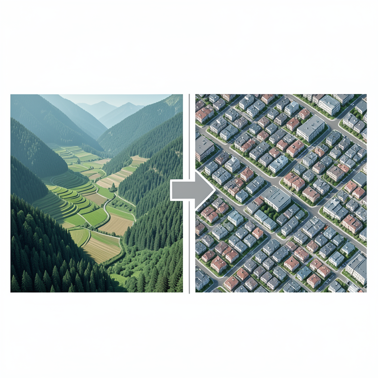
Land Use Shift
AI-generated conceptual illustration (Dharamshala city landscape in Himachal Pradesh, India). It explains the idea and does not show study data.
View source evidence ↗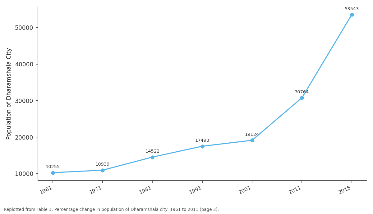
Population of Dharamshala City: 1961 vs 1971 vs 1981 vs 1991 vs 2001
Replotted from Table 1 (page 3) of the original paper. Every bar is the paper's own table value.
View source evidence ↗Figures & tables
From the original paper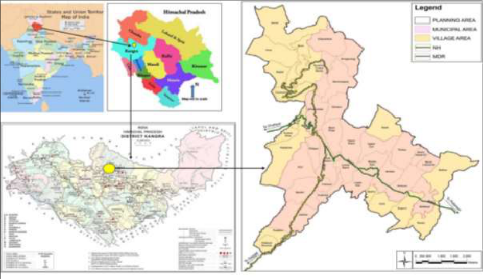 Figure 1
 Table 1
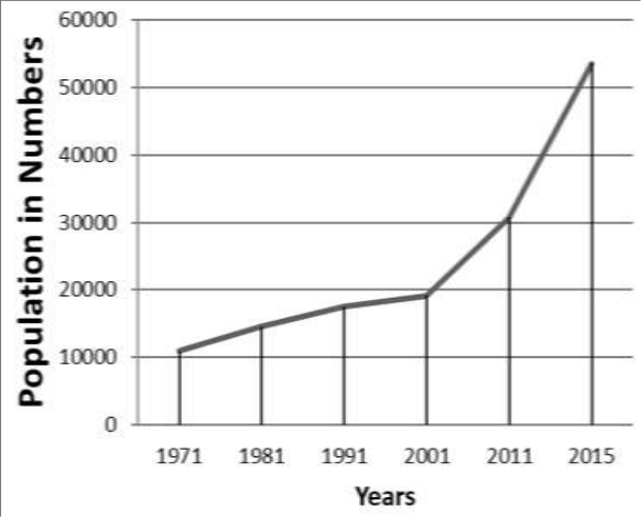 Figure 1
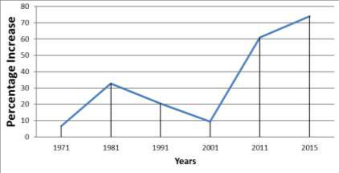 Figure 2
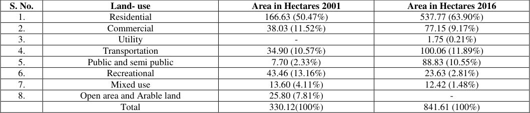 Table 2
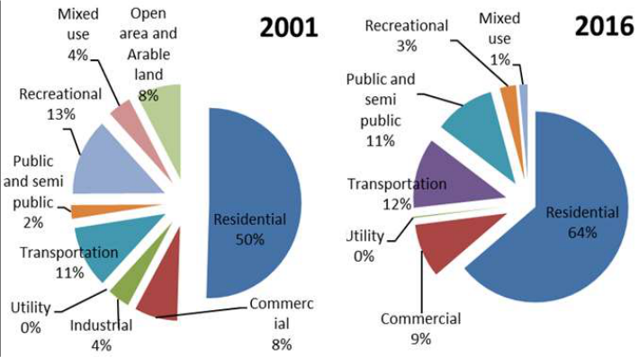 Figure 3
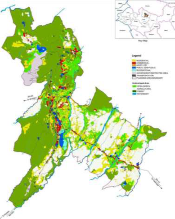 Figure 4
 Table 3
 Table 4
Introduction
Dharamshala is a city in Himachal Pradesh state which is located in the Kangra Valley's upper reaches. McLeodGanj, Bhagsunaag, Dharamkot, Naddi, Forsythganj, Kotwali Bazaar (major market area), Kaccheri Adda (which includes the government offices like the court complex, and main police station), Dari, Ramnagar, Sidhpur, and Sidhbari are amongst the suburbs of this city. It attained the honour of being second capital (after Shimla) of Himachal Pradesh in the year 2017. It has also been identified by government of India for transformation into smart city (Firstpost, 2015) [2] . Dharamshala is a city lying in the Tehsil of Dharamshala and it is managed by Municipal Corporation of Dharamshala (MCD). It enjoys the status of district headquarters with creation of Dharamshala tehsil. Dharamshala is a prominent center of Tibetan culture in India. In the study area, rapid urbanization is a recent phenomenon. There are number of problems emerging due to this urban expansion. As a result of the growing urban population, all countries, industrialized and developing, are confronting a multitude of ecological problems. As the population of urban areas grows, so does the rate of resource consumption. Due to availability of opportunities peoples are attracted towards that city and migration of the population in Dharamshala city has increased insignificantly. This growth in population leads to resource exploitation, resulting in air, water, and noise pollution, traffic congestion, and the creation of slums, among other things. Due to these environmental issues, the city of Dharamshala is losing its beauty, for which it is highly known. Rai et al. (2017) [9] stated that glaciers influence different type of natural systems in the environment and played major role for fresh water source.
Singh et al. (2020) [13] stated that rapid urbanization and demand regime, aggravated by tourism leading to increasing water insecurity in the Hindu Kush Himalayas. Dharamshala plannig area includes 33 revenue villages including municipal corporation limits. The total population of Dharamshala planning area is 62,279 of which the urban component contains 30,764 persons as per census 2011 (Census of India, 2011).
Statement of the problem
Statement of the problem
Study Area
Dharamshala is a city in Himachal Pradesh's northern state. Dharamshala is situated on the magnificent Kangra Valley slopes. Geographically, Dharamshala is positioned 23⁰13' North latitude and 75⁰19' East longitude. The town's top section is located at an elevation of 2100 meters, while the lower part is located at an elevation of 1250 meters (Government of Himachal Pradesh, 2017) [5] . Overall Dharamshala has subtropical climate which is humid during the monsoon season. According to the 2011 census, the city's population was 30764, and the city was spread over 1971, 1981, 1991, 2001, 2011 and Muncipal Corporation of Dharamshala (MCD), 2019.
The Table 1, Figure 1 and Figure 2 shows the decadal population increase in terms of numbers, growth rate and percentage increase of population. From past decades, the population of the city is increasing but decline in the population growth rate occurred during the last decade. This table shows that in 1971-81 there was steep rise in population of Dharamshala city. Large number of people not only from within the state but also from outside migrated here in search of employment. Further, dramatic increase of 60.87% and 74.04% was witnessed in time periods of 2001-2011 and 2011 to 2015, respectively.
| Year | Population of Dharamshala City | Actual Increase in Population | % Age Increase |
|---|---|---|---|
| 1961 | 10255 | - | - |
| 1971 | 10939 | 684 | + 6.67 |
| 1981 | 14522 | 3583 | +32.75 |
| 1991 | 17493 | 2971 | + 20.46 |
| 2001 | 19124 | 2489 | +14.23 |
| 2011 | 30764 | 2604 | +60.87 |
| 2015 | 53543 | 30,957 | + 74.04 |
Table text extracted from the original PDF; superscript letters are shown inline. The original table image is below.
View original table image
Source: Census of India, 1971, 1981, 1991, 2001, 2011 and MCD, 2019.
Factors contributing to population growth
The two major factors are responsible for the growth of population at any place. That is natural growth rate (birth rate-death rate) and migration. History reveals that the city of Dharamshala carries an ancient historical importance. The Dharamshala city has status of district headquarters with the creation of Dharamshala tehsil. So, urbanization and tourism industry in Dharamshala has boosted migration to the city and population increased rapidly. Sharma et al. (2018) [10] have investigated a statistical analysis of growth of Himachal Pradesh and they stated that the present day phase of globalisation, migratory population & urban growth are direct contributors in the economic expansion. The decline in growth rate seen over the last two decades is attributable to some push factors such as city congestion and a lack of basic services for the population. Rather than being a one-time event, urbanization is a continuous process that results in population and area growth over a short period of time, as seen in case of Dharamshala city from 1971 to 2011.
Changes in land use pattern of Dharamshala city
The use of land by humans for various activities is referred to as land use. It has been noticed that, in light of increasing population pressure on land and rising demand for food and other commodities, the pattern of land utilization has taken on special significance in emerging countries such as India, because as population increases, cultivated area decreases. The use of available land in a city is governed the city's geographical settings, socio-economic, and political conditions. Changing political and administrative geography played a major role for the growth of urban centres in Himachal Pradesh (Kant 1995) [6] . Residential, industrial, commercial, infrastructure (including transportation), and open spaces are the most common urban land uses.
Comparison of land use in Dharamshala city planning area 1. Residential land use
The nature of city is dominantly residential, about 56 percent of the total area was under this land use category in 2016. Also by comparison of land use patterns of 2001 to 2016, we can see that area percentage under this category has been above 50%. In future, if residential requirement is not considered it can lead to further haphazard expansion of this category. This demand for residential area is partially is due to importance of town as administrative headquarters, cultural headquarter of Tibetan population, development of hotel industry, Cricket stadium, etc. The city offers a diverse selection of housing options, including rental homes. Many residential areas in the Planning Area are inaccessible due to lack of access to motorable roads. Open area and Arable land 25.80 (7.81%) -Total 330.12(100%) 841.61 (100%) Source: Government of Himachal Pradesh, 1991 [4] , and 2017, MCD, 2011 [4][5] .
Commercial land use
Commercial growth has primarily occurred along major access routes leading from outside the Planning Area, as well as around tourist attractions. In the Planning Area, commercial stretches include Kotwali Bazar, Depot Bazar, Civil Bazar, Kachehari Bazar, McLeodGanj, Forsythganj, Dari Bazar, and Maximus Mall. The majority of commercial operations in this tourist attraction town are devoted to retail shops and hotels. Total area under the commercial use was 24.9 hectares in 2001 which has increased to 77.15 hectares.
Transportation land use
Transportation use in Dharamshala comprises of roads, bus terminus, bridges, parking lots, etc. For a hill town, the street network is quite extensive in Dharamshala but it is also a city preferred for its beauty by tourists, so MCD has to invest in developing roads, and as a result area under transportation has increased from10.57% in 2001 to 11.89% in 2016.
Source: MCD, 2011 and Government of Himachal Pradesh, 2017 [5]
Public and semi-public and utility land use
Offices, education facilities, and health facilities are among prominent usages considered under the public and semipublic land use category for Dharamshala city. Kachehri, Civil Lines, Cheelgari, Shamnagar, Ramnagar, Dari, Barol, and Sakoh, for example, are the areas where primarily the public and semi-public land usage is found. In 2016, under this land use category fell 88.83 hectares or 10.55% of total land use. Under utilities a meagre area of 1.75 hectares was devoted.
Recreational land use
The Dharamshala city is known for its serene beauty, but with increasing population pressure and increase in tourists foot fall more and mor land is being devoted to construction of housing and hotels. This often happens by infringing upon open spaces. So the city lacks a range of organized open and public places such as parks, playgrounds, recreation centers, and so on. Only a negligible share of land is used for recreational activities indicating a dearth of locations for community meetings and social events.
Mixed land use
Mixed-use construction has been seen along key roadways and near tourist attractions due to the city's status as a tourist destination. This use accounts for 12.42 ha of the total developed area, or around 1.48 percent of the total developed land in 2016 and it was little bit less as compared to 13.60 hectares in 2001.
Environmental and other issues faced by Dharamshala city
Dharamshala city faces issues regarding civic services like garbage disposal, traffic congestion, leaking water pipes and unchecked illegal constructions (Sharma, 2020) [12] . Another issue is of dealing with slums, water scarcity and degradation of natural environment caused by tourism related activities. The city is also facing geomorphic hazard of land sliding.
Slums
Many labourers from destitute sections of Rajasthan and Maharashtra states have relocated to Dharamshala, and living in slums of Charan Khad, which is located near the Dharamshala cricket stadium in the city's southern suburbs. Migrated people are mostly construction workers, daily wagers, street vendors and rag pickers they live in a haphazard manner in the city in their temporary settlements. The dwellings found in slums are 'kutcha' houses or 'Jhuggis'. From the comparison we noted that the population of both the slums is changed. Charan Khad has seen addition of 80persons in 2011 as compared to 2001. In Charan Khad, according to Municipal Corporation of Dharmshala (MCD) own survey about 1500 persons or about 290 families were living here in 2016. Similarly, Sham basti has seen an increase of 50 persons. In case of Charan Khad, the media sources mention that about 290 families who were living here since past 30 years, on June 17, 2016 were forcefully evicted by MCD and their flimsy dwellings were demolished and no efforts were made to rehabilitate them (Goswami, 2016; Nigar and Mahar, 2016; The Analysis, 2017; Vishwapremi, 2019) [3,8,15,16] . They were evicted because they were defecation in open, but by evicting them and not providing them housing, the issue of open defecation will still remain.
Impact of tourism
Most common consequence of tourism on the environment are: Changing the structure of local flora and fauna. Pollution of water, air and soil resources. Soil erosion and triggering of Landslides. Depletion of natural resources. Traffic congestion and public transport. Visual impact.
Unfortunately the local population is one that has to "pay" the costs of the resulting environmental degradation from tourist exploitation.
Municipal waste and associated water degradation
In Dharamshala, municipal waste disposal site is an open dump which lies at 32⁰14'51.4" N latitudes and 76⁰18'38.2"E longitudes at an altitude of 1821 m above mean sea level. It can be explained that biodegradable waste is managed at the dumping site through the composting process, whereas the major component of the waste, i.e. dry garbage, is left untreated. This not only results in a visually unpleasant surroundings, but it also create further issues such as frequent choking of sewerage system, pollution of water bodies, vector proliferation, and living conditions that are unsanitary, to name a few. For collection of waste, municipal committee, has placed containers at various identified sites but due to negligence of authorities and people it is not used accordingly. Also the areas lying outside MCD, especially hotels usually are burning garbage or throwing into water bodies due to lack of garbage disposal facilities.
Sterkele and Zurbrugg (2013) [14] investigated on water supply, sanitation and solid waste in upper Dharamshala. Water Scarcity is the major problem in the Dharamshala city. Increasing urban population, infrastructure development, climate change and the decrease in ground water recharge is also intensifying major water problems in the city (Sharma et al. 2019) [11] .
Mining
Mining in these locations is done in an illegal manner (Lal, 2018) [7] , with following mining processes that are completely unscientific. Slate mining has degraded the beauty of the woodlands, destroying flora and soil cover, depleting water resources, and destroying agricultural and forest land, resulting in erosion, stream silting, and triggering landslides.
Landslides
The slope of Dharamshala varies from gentle to steep. Landslides are one of Dharamshala's most common natural disasters as it falls in a seismic activity prone zone. Severe landslides usually occur during the rainy season and post high-intensity earthquakes. Anthropogenic activities like putting load by constructional activity especially on steep slopes is also a triggering factor. Increased urbanisation, deforestation, and encroachment of areas on steep hill slopes, as well as inappropriate road cutting and water-intensive farming activities, all contributed to a rise in landslide intensity and frequency. The state government and the district administration have done nothing to regulate and check unplanned and massive construction in active sliding zones (Behal, 2020) [1] .
Conclusion
Dharamshala city has faced a sharp change in its demography and there are many ecological consequences which have emerged out of these developments. This shift in the city's population-resources dynamic has resulted in a slew of issues. Rapid urbanisation, migration, population growth, and tourism have resulted in uncontrolled development. City being an administrative, cultural and educational centre attracts huge numbers of population. The areal growth of the city has increased manifold over past few decades. The population of city has increased at an alarming rate from 2001 to 2015, which has put pressure on land and water resources of the city. The residential area has also expanded a lot to meet with population pressure and in many cases this expansion has occurred in areas vulnerable to land sliding. The land under recreational use has faced decreased share while residential, transportation and governmental land use have increased share amongst the various land use categories. Poverty, ignorance and illiteracy are partial responsible for the problems of housing, crime, ill health and pollution in the Dharamshala city, especially in slum areas and lack of funding and negligence by concerned authority are also contributing factors.
Suggestions
There are many problems (over population, unemployment, slums, water and air pollution) in the city, which are rising gradually. Some suggestions regarding the study are as follows:
1. To control the ecological degradation in Dharamshala city, tourism industry should be more eco-friendly and the population pressure on the city should be reduced by planned horizontal expansion of city as vertical expansion is not safe due to the land sliding and increasing seismic activity risk.
2. The state government should focus on decentralizing of education facilities, employment opportunities in the rural areas which are lying near to the Dharamshala city. In this way, we can control the in-migration in the city from the adjoining rural areas. 3. There is need to control traffic congestion in the city and it's suburbs and people must be encouraged to use public transport during rush hour. 4. The process of making the city 'Slum-free' should be linked to overall economic development process. 5. Dharamshala city can become a smart city only when basic issues like proper disposal of garbage are immediately tackled.
Acknowledgement
AcknowledgementAuthors are thankful to Cambridge College, Sardarshahrand Punjabi University, Patiala where this research work was undertaken. We have not received any funding support from anywhere. Compliance with ethical standards
Figures and tables from the paper
| S. No. | Land- use | Area in Hectares 2001 | Area in Hectares 2016 |
|---|---|---|---|
| 1. | Residential | 166.63 (50.47%) | 537.77 (63.90%) |
| 2. | Commercial | 38.03 (11.52%) | 77.15 (9.17%) |
| 3. | Utility | - | 1.75 (0.21%) |
| 4. | Transportation | 34.90 (10.57%) | 100.06 (11.89%) |
| 5. | Public and semi public | 7.70 (2.33%) | 88.83 (10.55%) |
| 6. | Recreational | 43.46 (13.16%) | 23.63 (2.81%) |
| 7. | Mixed use | 13.60 (4.11%) | 12.42 (1.48%) |
| 8. | Open area and Arable land | 25.80 (7.81%) | - |
| Total | 330.12(100%) | 841.61 (100%) |
Table text extracted from the original PDF; superscript letters are shown inline. The original table image is below.
View original table image
| Sr. No. | Name of Slums | 2001 | 2011 | 2001 | 2011 |
|---|---|---|---|---|---|
| Population | Population | Number of households | Number of households | ||
| 1. | Charan Khad | 310 | 390 | 69 | 80 |
| 2. | Sham Basti | 200 | 250 | 45 | 69 |
| Total | 510 | 640 | 114 | 149 |
Table text extracted from the original PDF; superscript letters are shown inline. The original table image is below.
View original table image
References
6 in the original paper- Government of Himachal Pradesh. Dharamshala Planning Area Development Plan-2035. Department of Town and Country Planning, Government of Himachal Pradesh; c2017. Available from: http://tcp.hp.gov.in/Application/uploadDocuments/devl opmentPlan/PlanDoc020171226_122950.pdf.
- Kant S. Urbanisation in Himachal Pradesh during the present century. Population Geography. A Journal of the Association of Population Geographers of India. 1995;17(1-2):49-64.
- Lal M. Shocking video/photos expose Govt Officer's lies about illegal slate mining in Dharamshala; c2018. Available from: https://himachalwatcher.com/2018/07/07/shockingvideo-photos-expose-govt-officers-lies-about-illegalslate-mining-in-dharamshala/.
- Sharma AR, Tanwar S, Rizvi S. Growth of urbanization in Himachal Pradesh: A Statistical Analysis. International Journal of Engineering & Technology. 2018;7(1-4):39-46.
- Singh. Urbanisation and water insecurity in the Hindu Kush Himalaya: Insights from Bangladesh, India, Nepal and Pakistan. Water Policy. 2020;22(S1):09-32.
- The Analysis. Charan Khad Slum Demolition: A story of lost human rights; c2017. Available from: https://theanalysisweb.wordpress.com/2017/07/01/chara n-khad-slum-demolition-a-story-of-lost-human-rights/.
Cited by 7
From OpenAlex, OpenCitations and reference lists read by Scinovex
- Mapping urban stress and green depletion in Shimla using remote sensing: A step towards sustainable urban future
Praveen K. Thakur, Sunil Jaswal - · International Journal of Geography Geology and Environment · 2025
The tracking of vegetation dynamics and urban growth is necessary for ecologically sound environmental planning, especially in ecologically vulnerable areas such as Himachal Pradesh. This paper provides a detailed examination of the seasonal correspondence between NDVI (normalized difference vegetation index) and NDBI (normalized difference Built-up index) from 2019 to 2024 based on Sentinel-2 imagery, chosen for its high spatial resolution and regular availability from 2019. A total of 50,000 spatially distributed but fixed points were analyzed across all districts of Himachal Pradesh. Karl P
- Evaluating Spatial Morphology of Urban Agglomerations in Himachal Pradesh ↗
Sarita Debnath, K. Dhanaraj · Lecture notes in civil engineering · 2026
❝ 0 - Living on the margins: A socio-economic and environmental assessment of urban slum clusters in India ↗
R Bengani · International Journal of Social Science and Education Research · 2025
In a general context, urban slums represent a blend of urban poverty, infrastructure decay, and socio-economic exclusion. The present research estimated the population profile, literacy rate, employment nature, water and sanitation status, and child health indicators for five slum clusters: Govalak, Morarji Vasahat, Banjaravas, Halpativas, and Ambedkarnagar. Although some clusters, such as Ambedkarnagar, exhibit relatively higher education levels, there is
- Urbanization and eco-activism: Civil society responses in Darjeeling and Kalimpong ↗
Sayani Shome · International Journal of Political Science and Governance · 2025
Urbanization is a widespread trend across the globe, including in India. While rapid urban growth is opening up various opportunities for everyday people, it also brings along some negative consequences for cities. In particular, the environment in these urban areas is suffering due to the chaotic and uncontrolled nature of urbanization in India, especially in North Bengal. The hill towns
- Urban Futures: Coordinated Urbanization as a Catalyst for Ethiopia’s Development ↗
Vivek Kumar · International Journal of Political Science and Governance · 2025
The process of urbanization is among the most revolutionary processes that influence the social economic and political environment across the globe. Ethiopia has one of the lowest urbanization rates in Sub-Saharan Africa and the rapid urbanization process in the country is being induced by rural-to-urban migration and natural population growth. The economic growth caused by planned and well-organized urban development
- Integrating Smart City Technologies for Sustainable Tourism Development in Dharamshala: Strategies, Challenges, and Community Impact ↗
Nihal Kapoor, Amrik Singh · Emerald Group Publishing Limited eBooks · 2025
Dharamshala, located in the Indian state of Himachal Pradesh, is renowned for its picturesque landscapes, vibrant Tibetan culture, attracting tourists worldwide. “Smart Cities and Sustainable Tourism in Dharamshala” explores the convergence of smart city projects with sustainable tourism in the region of Dharamshala, which is known for its abundant cultural history and natural splendor. Dharamshala’s smart city projects aim to…
❝ 0 - NABARD empowers tribal livelihoods and environment in Maharashtra through Wadi project ↗
Prashant B. Narnaware, Om Prakash Shukla · International Journal of Humanities and Education Research · 2024
Constituting approximately 8.6 percent of India's total population according to the 2011 census, the states of Madhya Pradesh, Chhattisgarh, Maharashtra, Odisha, Jharkhand, and Gujarat collectively harbour more than half of the country's tribal population. With traditional means of livelihood increasingly threatened, the issue of tribal livelihoods has assumed paramount significance. However, development strategies employed in tribal areas have failed to