
Research article · 2024 · Full text
International Journal of Geography Geology and EnvironmentA geographical study of change in fruit cultivation area in Latur District
Volume 6(1) · Pages 109–112 · DOI: 10.22271/27067483.2024.v6.i1b.209 ↗
Research areasGlobal Trade and Competitiveness
Abstract
Author-writtenThe document is focusing on the change in fruit cultivation area in Latur District, Maharashtra, from 2010-11 to 2021-22. It highlights Maharashtra's role in India's horticulture, with a significant portion of fruit exports originating from the state. Latur, despite its irrigation challenges, has seen changes in orchard areas over the decade. The study employs secondary data, including government reports and statistical analysis, to examine the hectare-wise and percentage-wise changes in fruit cultivation across Latur's talukas, revealing shifts in major fruit crops like mango, grape, and banana.
Summary
Source-checkedPlain-language reading of the full paper, prepared with AI and checked against the text. Each point links to the authors' own words.
Why it matters
- Maharashtra is a primary leader in India's agricultural sector, specifically regarding the production and export of horticultural products. View evidence ↗
- The state handles 60% of India's total fruit exports, including the vast majority of grapes (98%) and a significant portion of pomegranates (80%), mangoes (60%), and bananas (56%). View evidence ↗
- In the Latur district, farmers utilize orchards as a source of cash crops. View evidence ↗
The question
- The study aims to examine the changes in the orchard sector within the Latur district between the years 2010-11 and 2021-22. View evidence ↗
What they did
- The research utilized secondary data from published literature, the Latur district Gazetteer, and Social and Economic Review Reports from 2010-11 and 2020-21. View evidence ↗
- The analysis focused on hectare-wise and percentage-wise changes in the cultivation of major fruits, specifically mango, grape, and banana, across the district's talukas. View evidence ↗
What they found
- The total area dedicated to fruit cultivation in Latur district decreased from 3248.56 hectares in 2010-11 to 3096 hectares in 2021-22. View evidence ↗
- Over the decade, the district experienced a total decrease of 152.56 hectares in fruit cultivation area, representing a 4.7% decline. View evidence ↗
- Chakur taluka showed the most significant growth, with an increase of 232.1 hectares, which is a 294.2% increase. View evidence ↗
- Jalkot taluka experienced the sharpest decline, losing 396.6 hectares of fruit cultivation area, a decrease of 83.7%. View evidence ↗
- Other talukas that saw increases included Latur (123 hectares, 30.40%), Shirur Anantpal (47.4 hectares, 41.4%), and Devani (7.1 hectares, 9%). View evidence ↗
- Decreases were also noted in Renapur (89.91 hectares, 23.4%), Ahmedpur (81.5 hectares, 22.54%), Nilanga (14.4%), and Udgir (5.23 hectares, 1.5%). View evidence ↗
What it means
- The authors conclude that the fruit cultivation area in Latur district overall declined by 152.56 hectares, or 4.7%, over the studied decade. View evidence ↗
Visual summary
2 visualsIllustrations explain the paper; charts are replotted from the paper's own table values.
Overall Area Trend
AI-generated conceptual illustration (Fruit orchards in Latur District, India). It explains the idea and does not show study data.
View source evidence ↗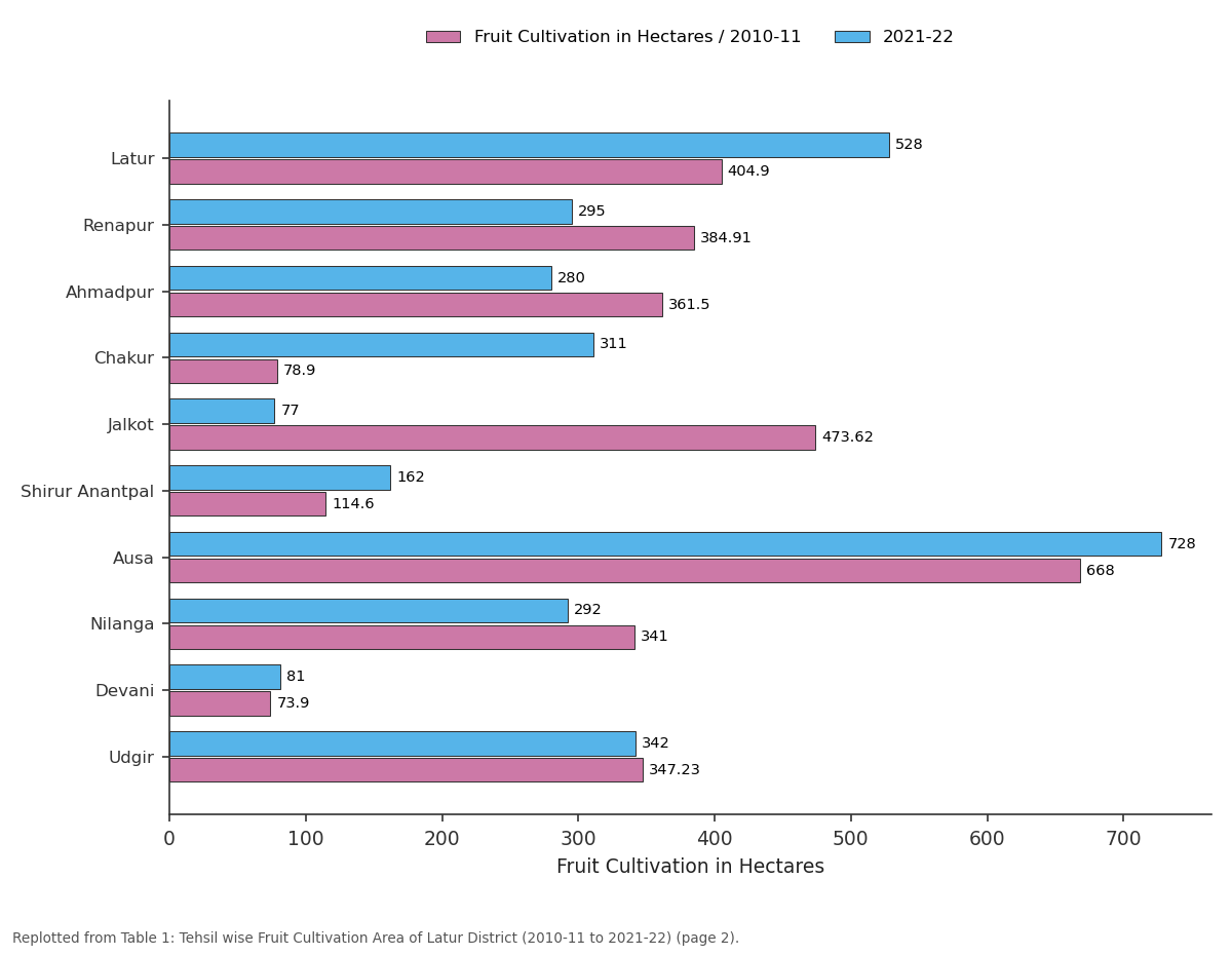
Fruit Cultivation in Hectares / 2010-11 and 2021-22: Latur vs Renapur vs Ahmadpur vs Chakur vs Jalkot
Replotted from Table 1 (page 2) of the original paper. Every bar is the paper's own table value.
View source evidence ↗Figures & tables
From the original paper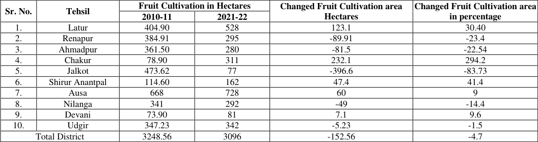 Table 1
Introduction
India is an agricultural country. Maharashtra is a leading state in the country in the field of agriculture. Due to the diverse climate of the state, the production of various types of fruits is taken in the state of Maharashtra. Compared to other states in the country, farmers in Maharashtra are progressing in adopting improved technology.
So state of Maharashtra is the leading state in horticulture production and export. The state of Maharashtra mainly has a large area of grape, pomegranate, banana, orange, cashew and mango. Out of the total exports of the country, 60 percent of fruits are exported through Maharashtra, out of which 98% of grapes, 80% of pomegranates, 60% of mangoes and 56% of bananas are exported from Maharashtra. In Latur district too, orchards are seen as a cash crop by farmers.
In the present research paper, the change in orchard sector in Latur district from year 2010- 11 to the 2021-22 has been studied. Despite the lack of irrigation facilities, lack of large dams, lack of large rivers in Latur district, an attempt has been made to study the changes in the orchard sector over the decade. Study Area Latur district was formed on 16 August 1982. Latur district has a latitudinal extent of 18° 5' to 18° 7' north latitude and a longitudinal extent of 73° 25' to 77° 25' east longitude.
The area of this district is 7,157 sq km. The population of this district as per 2011 census was 24, 54, 196. The literacy rate of this district was 79.03%. There are total 10 talukas in Latur district; Latur, Ahmedpur, Udgir, Nilanga, Ausa, Renapur, Chachur, Devani, Jalkot and ShirurAnantpal etc.
Manjra is the major river in Latur district. Rena, Manyar, Terna, Tawarja, Gharni and Lendi tributaries are found to be effective for irrigation in Latur. Dams and barrages have been constructed on Manjara River and its tributaries for irrigation and water supply. Major dams include Devargan, Gharni, Masalga, Sakol, Tawarja and Tiru.
The irrigation area in Latur district is based on the above dam’s areas and dams built on the rivers. IJGGE 2024; 6(1): 109-112 Dr. Katke Arjun Keshav Assistant Professor, Shri Chhatrapati Shivaji College, Omerga, Dharashiv, Maharashtra, India Dr. Katke Arjun Keshav Assistant Professor, Shri Chhatrapati Shivaji College, Omerga, Dharashiv, Maharashtra, India https://www.geojournal.net/ Map 1: Latur district location map Objectives 1.
To study Tahashil wise Fruit Cultivation area in the year 2010-11 and 21-22 of Latur district. 2. To study the hectare wise change in Fruit Cultivation area in each taluka during the decade 2010-11 to 2021- 22 of Latur district. 3. To study the percentage wise change in each taluka in Fruit Cultivation area during the decade 2010-11 to 2021-22 of Latur district. Research Methodology This research paper is based on secondary data.
Published literature has been used in this paper. Latur district Gazetteer as well as Latur District Social and Economic Review Report 2010-11 and 2020-21 and appropriate statistical methods and websites have been used to analyze the data obtained. Fruit Cultivation area Mango, grape and banana are the major crops in Latur district. As per to Table No. 01, it is seen that in the year 2010-11, 3248.56 hectares area was under Fruit Cultivation.
The area under Fruit Cultivation in the year 2021-22 was 3096 hectares. Latur district has seen 152 hectardecreasein Fruit Cultivation area during this decade. Taluka wise Fruit Cultivation area, in 2010-11 is as, Ausataluka had the highest Fruit Cultivation area at 668 hectares. Next to that, Jalkot 473.62 hectares, Latur 404.90 hectares, Renapur 384.91 hectares, Ahmedpur 361.50 hectares, Renapur 2100 hectares and Nilanga 341 hectares are seen.
Table 1: Tehsil wise Fruit Cultivation Area of Latur District (2010-11 to 2021-22) Changed Fruit Cultivation area Sr. No. Tehsil Fruit Cultivation in Hectares Changed Fruit Cultivation area Hectares in percentage 2010-11 2021-22 1. Latur 404.90 528 123.1 30.40 2.
| Sr. No. | Tehsil | Fruit Cultivation in Hectares | — | Changed Fruit Cultivation area Hectares | Changed Fruit Cultivation area in percentage |
|---|---|---|---|---|---|
| 2010-11 | 2021-22 | ||||
| 1. | Latur | 404.90 | 528 | 123.1 | 30.40 |
| 2. | Renapur | 384.91 | 295 | -89.91 | -23.4 |
| 3. | Ahmadpur | 361.50 | 280 | -81.5 | -22.54 |
| 4. | Chakur | 78.90 | 311 | 232.1 | 294.2 |
| 5. | Jalkot | 473.62 | 77 | -396.6 | -83.73 |
| 6. | Shirur Anantpal | 114.60 | 162 | 47.4 | 41.4 |
| 7. | Ausa | 668 | 728 | 60 | 9 |
| 8. | Nilanga | 341 | 292 | -49 | -14.4 |
| 9. | Devani | 73.90 | 81 | 7.1 | 9.6 |
| 10. | Udgir | 347.23 | 342 | -5.23 | -1.5 |
| Total District | 3248.56 | 3096 | -152.56 | -4.7 |
Table text extracted from the original PDF; superscript letters are shown inline. The original table image is below.
View original table image
Renapur 384.91 295 -89.91 -23.4 3. Ahmadpur 361.50 280 -81.5 -22.54 4. Chakur 78.90 311 232.1 294.2 5. Jalkot 473.62 77 -396.6 -83.73 6.
Shirur Anantpal 114.60 162 47.4 41.4 7. Ausa 668 728 60 9 8. Nilanga 341 292 -49 -14.4 9. Devani 73.90 81 7.1 9.6 10.
Udgir 347.23 342 -5.23 -1.5 Total District 3248.56 3096 -152.56 -4.7 Source: Director of Economic and Statistics Report in Latur District Graph 1: Changed Fruit Cultivation area Hectares https://www.geojournal.net/ Anantapaltaluka 162 hectares. Taluka wise the lowest fruit cultivation area of Latur district is noticed in Jalkottaluka is 77 hectare, & Devani 81 hectare. Changes in fruit cultivation Area Taluka wise Devani and Chakur have the lowest fruit cultivation area with 73.90 and 78.90 hectares. As per table number 01, in the year 2020-21, maximum Fruit Cultivation area is seen in Ausataluka that is 728 hectares, Latur 528 hectares, Udgir 342, Chakur 311, Renapur 295 hectares, Nilanga 292, Ahmedpur 280 hectares and Shirur Graph 2: Changed Fruit Cultivation area Hectares fruit cultivation area in Latur district, it is seen that Jalkottaluka has the highest decrease of 396.6 hectares, Renapur 89.91 hectares, Ahmedpur 81.5 hectares and Udgirtaluka 5.23 hectares.
As per Table No. 01 considering the change in the decade from 2010-11 to 21-22, the highest increase in fruit cultivation area is seen in Chakurtaluka at 232.1 hectares. In Latur taluka 123 hectare, Shirur Anantpal 47.4 hectare, Devani 7.1 hectare. Looking at the taluka-wise decrease in Graph 3: Changed Fruit Cultivation area in percentage district has been observed during the decade2010- 11 to 2021-22. 2. It appears that taluka wise increase is seen in fruit cultivation area in Latur district, Chakur is the highest and Latur, Shirul Anantpaltalukas come next to it. 3.
It appears that taluka-wise decrease is observed in fruit cultivation area in Latur district, the highest decrease has been observed in Jalkot, and then Renapur, Ahmedpur and Nilanga. 4. Percentage wise growth of fruit cultivation area in each Looking at the percentagewise change in fruit cultivation area in Latur district, the highest increase in this decade is seen as follows Chakurtaluka 294.2%, Shirur Anantpal 41.4%, Latur, 30.40%, Devani 9%. Looking at the negative changes in the fruit cultivation sector in Latur district, Jalkottaluka has seen the highest decrease by 83.7% and Renapurtaluka by 23.4%. Next to Ahmedpur 22.54, Nilanga 14.4% and Udgir 1.5%.
Conclusion
1. It is seen that fruit cultivation area in Latur district has a decrease of 152.56 hectares during the decade A 4.7 percent decrease in fruit cultivation area in Latur taluka of Latur district is seen in the order of Chakur, Latur and Shirul Anantpal respectively. 5. Percentage wise decrease in fruit cultivation area is https://www.geojournal.net/ seen in Jalkot, Renapur, Ahmedpur and Nilanga have seen a decline respectively.
References
6 in the original paper- Angadi DP. Spatio-Temporal Analysis of Agricultural Land Use in India. Kanpur: Alka Prakashan; c2012.
- Chopra G. Agriculture Geography. New Delhi: Commonwealth Publication Ansari Road; c2006.
- Rao C. Agricultural Geography. New Delhi: Visva Bharati Publication; c2009.
- Singh I. Agricultural Geography. New Delhi: Discovery Publishing House; c2007.
- Hota D, Kalatippi AS, Nayak JK, Karna AK. Genetic transformation of fruit crops: A review. Int J Hortic Food Sci. 2020;2(1):49-51.
- Kumbhar AR. Agricultural Geography. Payal Publications; c2004.
Cited by 2
From OpenAlex, OpenCitations and reference lists read by Scinovex
- Geographical Study of the Impact of Climate Uncertainty on Agricultural Productivity in Latur District (2015-2026)
Arjun Keshav Katke, Prof. Dr. Satish D. Gavit · International Journal of Geography Geology and Environment · 2026
Latur district, located in the Marathwada region of Maharashtra, is one of the most drought-prone districts in the state. Agriculture in the district is predominantly rainfed; therefore, climatic uncertainty—manifested through fluctuations in rainfall, recurring droughts, and rising temperatures—has a direct impact on agricultural productivity. This study examines the nature of climate uncertainty and its geographical impact on agricultural productivity during the period from 2015 to 2026.The study is based on secondary data collected from District Socio-Economic Reviews, rainfall records, and
- Statistical analysis of drought impact on agricultural sector in Latur district, Maharashtra
Veena Jadhav · International Journal of Statistics and Applied Mathematics · 2025
The agricultural sector is the backbone of Indian economy, contributing a significant share of the country’s GDP. Last few decades agriculture losses have grown due to irregularity in monsoon and change in climatic conditions over Indian sub-continent. Drought is a global phenomenon. It mainly affects on agricultural and allied sector activities. Agriculture plays a substantial role in the development of rural economies in the development of countries, where agriculture largely depends on rainfall. The Latur district in Maharashtra has faced recurring droughts over the past decade, severely af