
Research article · 2026 · Full text
International Journal of Geography Geology and EnvironmentSpatial assessment of natural radioactivity and radiological hazards in agricultural soils of Najaf Governorate, Iraq using gamma-ray spectrometry
Volume 8(9) · Pages 217–221 · DOI: 10.22271/27067483.2026.v8.i9c.881 ↗
Research areasRadioactivity and Radon MeasurementsHeavy metals in environmentGeochemistry and Geologic Mapping
Abstract
Author-writtenNatural radioactivity in agricultural soils is an important environmental issue since naturally occurring radionuclides contribute to the terrestrial radiation and may vary spatially according to geological and soil characteristics. The present study aimed to evaluate the spatial distribution of the natural radioactivity in the agricultural soils of Najaf Governorate, Iraq using the gamma rays spectrometry and the Geographic Information System (GIS) techniques. Thirty surface soil samples were collected from selected agricultural areas and analyzed for their activity concentrations of uranium, thorium and potassium. Results showed the concentration of uranium ranged from 17.9-27.3 Bq/kg with a mean of 22.1 ± 2.6 Bq/kg and thorium ranged from 20.8-30.1 Bq/kg with a mean of 25.5 ± 2.5 Bq/kg. Potassium had the highest activity concentrations 273-405 Bq/kg with a mean value of 333.3 ± 36.3 Bq/kg. The mean concentrations were lower than the UNSCEAR world population weighted soil averages of 30 Bq/kg uranium-238, 42 Bq/kg thorium-232 and 512 Bq/kg potassium-40 The spatial variation obtained among the sampling sites may be associated with the different geological parent materials, mineral composition, weathering, redistribution of sediments and agricultural conditions. GIS analysis was an effective tool to visualize the spatial distribution of the radionuclides and to identify areas with relatively higher or lower activity concentrations. The results in general provide a useful baseline of natural radioactivity in the agricultural soils of Najaf Governorate and give supportive information for future environmental monitoring and radiological hazard assessment.
Summary
Source-checkedPlain-language reading of the full paper, prepared with AI and checked against the text. Each point links to the authors' own words.
Why it matters
- Natural radioactivity in agricultural soils is a significant environmental concern because radionuclides contribute to terrestrial radiation and their levels vary based on soil and geological characteristics. View evidence ↗
- Agricultural soils are particularly important for radioactivity studies because they act as a boundary between human activities, crops, groundwater, and geological materials. View evidence ↗
What they did
- GPS was used to record the geographic coordinates of each sampling site, which were then linked to the radiological measurements. View evidence ↗
What they found
- Thorium concentrations ranged from 20.8 to 30.1 Bq/kg, with a mean value of 25.5 ± 2.5 Bq/kg. View evidence ↗
- The mean concentrations of uranium-238, thorium-232, and potassium-40 were all lower than the UNSCEAR world population weighted soil averages (30 Bq/kg, 42 Bq/kg, and 512 Bq/kg, respectively). View evidence ↗
What it means
- The authors conclude that the natural radioactivity in the studied agricultural soils is generally consistent with reported natural background levels for terrestrial environments. View evidence ↗
- The study provides a useful radiological baseline for the agricultural soils of Najaf Governorate to support future radiological assessments and environmental monitoring. View evidence ↗
Visual summary
2 visualsIllustrations explain the paper; charts are replotted from the paper's own table values.
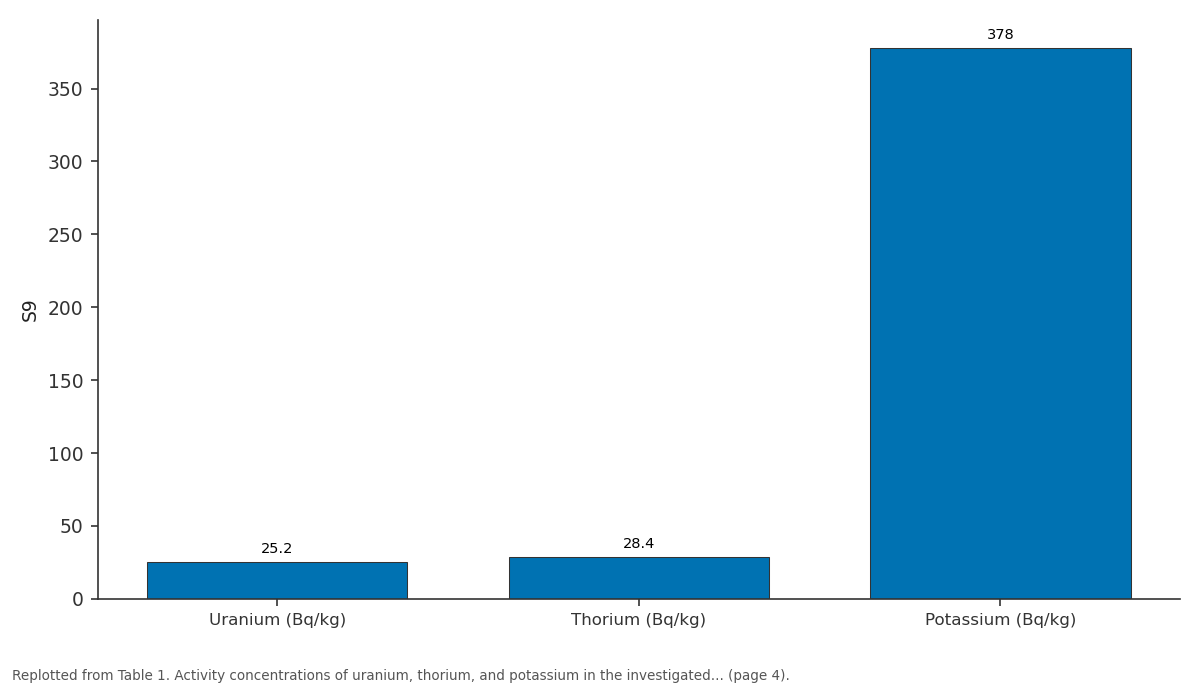
S9: Uranium (Bq/kg) vs Thorium (Bq/kg) vs Potassium (Bq/kg)
Replotted from Table 1 (page 4) of the original paper. Every bar is the paper's own table value.
View source evidence ↗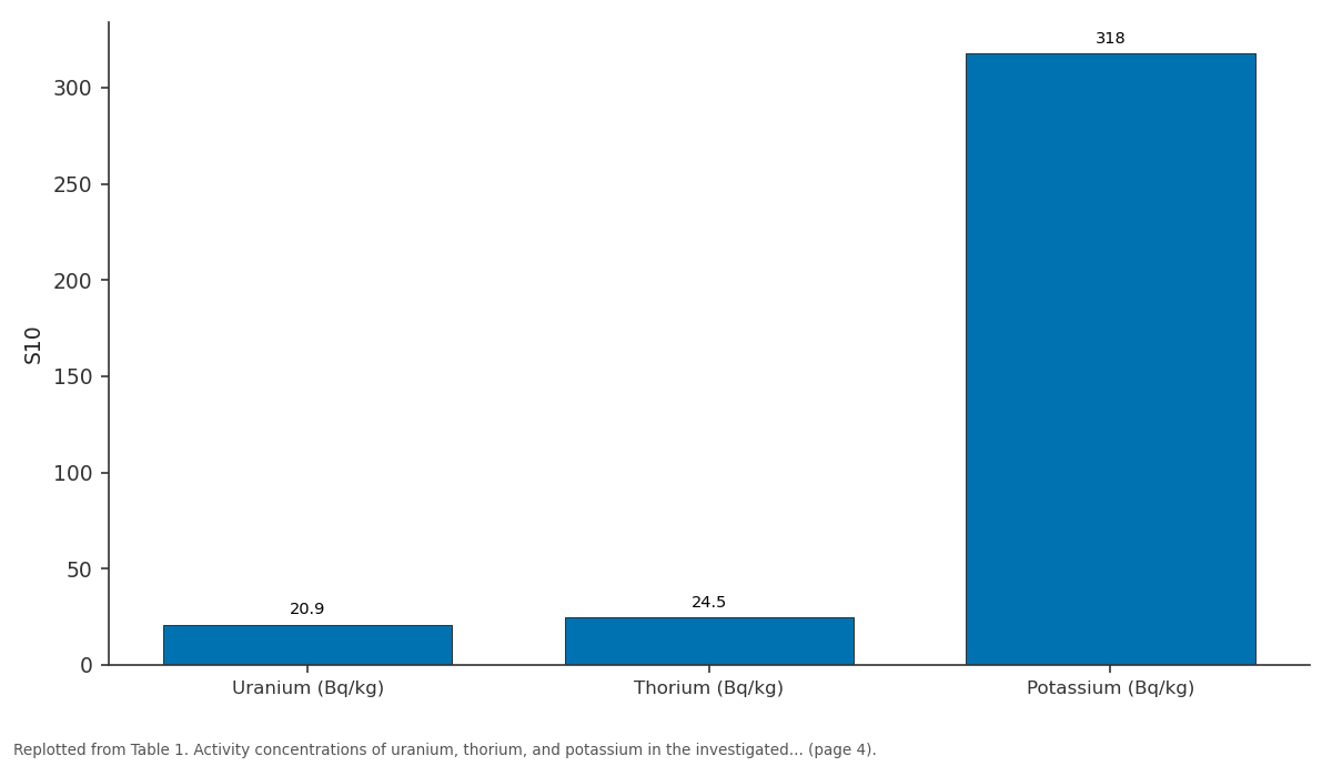
S10: Uranium (Bq/kg) vs Thorium (Bq/kg) vs Potassium (Bq/kg)
Replotted from Table 1 (page 4) of the original paper. Every bar is the paper's own table value.
View source evidence ↗Figures & tables
From the original paper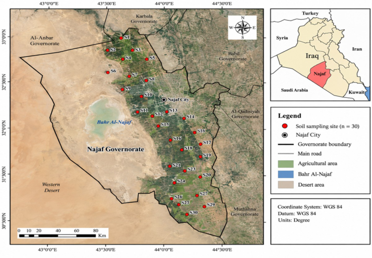 Figure 1
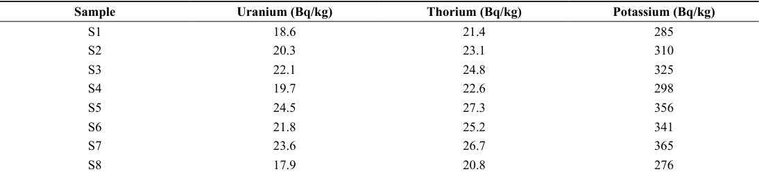 Table 1
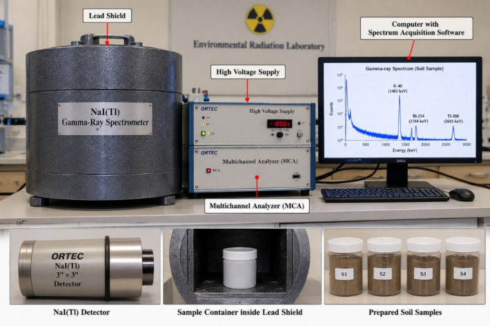 Figure 2
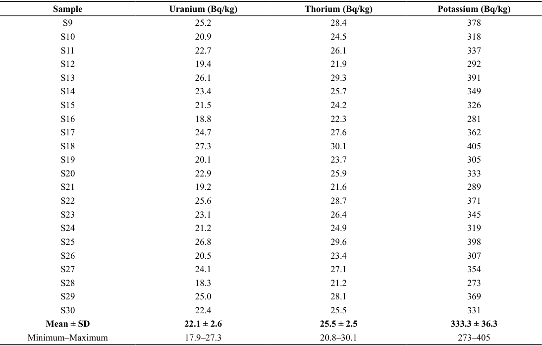 Table 1
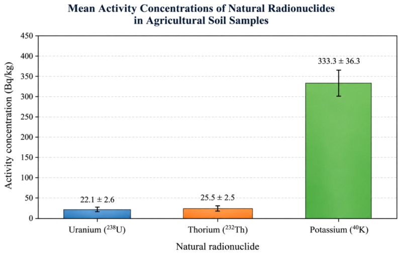 Figure 3
Introduction
Natural radioactivity is an integral part of the terrestrial environment and is always present in rocks, soils, sediments and other environmental matrices . The main natural radionuclides that contribute to terrestrial radiation are the uranium and thorium decay series and potassium-40. Their levels in soil depend on the geology, the minerals present, the weathering, the nature of the soil and the environment . Therefore, the assessment of natural radioactivity in soils is significant when trying to determine the radiological background levels and to evaluate the potential environmental radiation exposure (UNSCEAR, 2024; UNSCEAR, 2016) [1,2] . In studies on environmental radioactivity, agricultural soils are of special importance, as they represent a boundary between geological materials, groundwater, crops and human activities. In addition, soil may contain natural radionuclides that can contribute to external gamma radiation. The spatial distribution of soils is subject to variation which can be significant at different locations due to differences in parent material, mineral composition, erosion, sediment deposition and other soil forming processes. Hence, a spatial assessment is needed to get a more reliable knowledge of the natural radioactivity distribution in an agricultural region (UNSCEAR, 2024; IAEA, 2003) [1,3] . Gamma-ray spectrometry is a well established technique for the determination of naturally occurring radionuclides in environmental samples. It allows identification and quantification of radionuclides from their characteristic gamma-ray emissions. It provides a practical approach to soil sample analysis. The activity concentrations obtained in this work can be used to estimate several radiological parameters such as radium equivalent activity, absorbed gamma dose rate, annual effective dose, external and internal hazard indices and excess lifetime cancer risk. These parameters are more general indicators of the possible radiological significance of natural radionuclides present in the soil (UNSCEAR, 2024; IAEA, 1989) [1,4] . Najaf Governorate is an important region for the study of environmental radioactivity because of the wide agricultural activities and the variable geological and geographical characteristics. Natural radionuclides in soil and differences of their concentrations and associated radiological parameters among sampling locations were reported in previous studies in Najaf (Hasan et al., 2021; Alasadi et al., 2022) [5,6] .
These spatial variations underline the importance of systematic monitoring and mapping of natural radioactivity, especially in agricultural areas, where soils are directly involved in food production and environmental processes. Geographic Information System (GIS) techniques are an effective tool to combine radiological measurements with geographical information. GIS based spatial analysis and interpolation methods can be used to visualize distribution of radionuclides and radiological hazard parameters and to identify areas with relatively higher or lower values. Thus, the use of gamma-ray spectrometry in conjunction with GIS can provide a more complete methodology for environmental radiological assessment than either measurement technique alone (Alasadi et al., 2022; Dosh et al., 2023) [6, 7] . Therefore, the present study aims to assess the spatial distribution of natural radioactivity and its associated radiological hazards in agricultural soils of Najaf Governorate, Iraq, using gamma-ray spectrometry and GIS techniques. The study aims to determine the concentrations of naturally occurring radionuclides of uranium and thorium series and potassium-40 and their radiological hazard indicators. The results are expected to provide a useful baseline for monitoring of environmental radiation and contribute to the assessment and sustainable management of agricultural soils in Najaf Governorate.
Study area
The study was conducted in Najaf Governorate, central Iraq, about 160 km south of the capital Baghdad. Najaf Governorate has an arid climate with high temperatures, low annual rainfall and high rates of evaporation. The development of soils and the distribution of naturally occurring radionuclides in the environment are controlled by the climatic conditions and the geological and geomorphological features of the region. The study area includes agricultural lands scattered in selected sites in Najaf Governorate. The spatial differences in natural radioactivity may be due to the underlying geological materials, sedimentary deposits, irrigation practices and environmental processes which influence these soils. Thus, the area provides a suitable environment for studying the distribution of naturally occurring radionuclides and their radiological characteristics. Soil sampling sites were chosen to represent the spatial coverage of the studied agricultural areas. At each selected location surface soil samples were collected, labeled and prepared for laboratory gamma-ray spectrometric analysis. The geographic coordinates of the sampling sites were recorded by a Global Positioning System (GPS) and then combined with the radiological measurements in a Geographic Information System (GIS). This approach allowed to estimate the spatial distribution of radionuclide concentrations and parameters of radiological hazard in the study area. The geographical distribution of the sampling sites and the corresponding radiological results were then used to prepare spatial maps of natural radioactivity. The maps give a visual illustration of the variations in the radionuclide concentrations and associated radiological hazards, enabling identification of areas with relatively higher or lower values.
Materials and methods
Materials and methods
Soil sampling and sample preparation
Thirty surface soil samples were taken from selected agricultural areas distributed over the Najaf Governorate, Iraq. Figure 1 shows the sampling sites which were chosen to represent the study area spatially. At each site, soil samples were collected using clean sampling tools, placed in a labeled polyethylene bag and transported to the laboratory. The geographic coordinates of all sampling sites were recorded with a Global Positioning System (GPS) and then linked to the corresponding radiological measurements (Ibrahim et al., 2025) [8] . In the laboratory the soil samples were washed to remove stones, roots and other visible materials. Samples were dried to constant weight, homogenized and sieved to obtain a uniform sample fraction. The prepared samples were weighed and placed in sealed counting vessels. The containers were tightly sealed and stored for a suitable period of time to achieve radioactive equilibrium between radium and its short-lived decay products before gamma-ray measurements (IAEA, 2014) [9] .
Gamma-ray spectrometric analysis
The prepared soil samples were then analyzed by gamma-ray spectrometry to determine the activity concentration of the naturally occurring radionuclides associated with the uranium and thorium decay series and potassium-40. Gamma-ray spectrometry is a direct method for the identification of radionuclides based on their characteristic gamma-ray emissions and is widely used in environmental radioactivity studies (IAEA, 2014; ICRP, 1991) [9,10] . For each sample, the gamma-ray spectrum was measured under controlled conditions. The activity concentration of each radionuclide was determined from the characteristic photopeaks corresponding, taking into account the sam ple mass, counting time, detector efficiency and probability of gamma-ray emission. The energy and efficiency calibration with background measurements (IAEA, 2014; ICRP, 1991) [9,10] was used for the verification of the reliability of the analytical results. [11,12,13] . The differences observed between the sampling locations may be attributed to the variability in geological parent materials, mineral composition, soil properties, weathering, erosion and sediment redistribution. Uranium and thorium are tied to certain mineral phases, while potassium-40 is very much associated with potassium bearing minerals like feldspar and clay minerals (Dabayneh et al., 2008; Ahmed et al., 2024) [11,12] . Previous studies in Najaf have also shown spatial variation in the concentrations of naturally occurring radionuclides in soil, which supports the variation observed in the present study (Dabayneh et al., 2008; Abojassim et al., 2025) [11,14] . The average uranium content of 22.1 Bq/kg was lower than the revised world average for the population of about 30 Bq/kg, and the average thorium content of 25.5 Bq/kg was lower than the world aver-age of 42 Bq/kg. The mean potassium concentration of 333.3 Bq/kg was also lower than the worldwide average of about 512 Bq/kg (IAEA, 2014) [9] . Such differences are expected as the natural radionuclides concentrations can vary significantly depending on geological setting, soil mineralogy and environmental conditions (Dabayneh et al., 2008; Ahmed et al., 2024) [11,12] . The relatively bigger variation of potassium concentrations may be a reflection of the differences in the abundance and distribution of potassium bearing minerals in the agricultural areas. Local variations in radionuclide concentrations may also result from conventional agricultural methods, irrigation, sediment deposition or soil redistribution (Dabayneh et al., 2008; Ali et al., 2024) [11,13] . To be able to evaluate the natural radiological characteristics of agricultural soils, the spatial distribution of these radionuclides must be considered. The combination of the measured concentrations and GIS is an efficient tool for visualizing the spatial pattern and identifying the areas of comparatively higher or lower radioactivity. The previous studies have demonstrated the usefulness of GIS techniques in mapping natural radioactivity in Iraqi soils and improving the interpretation of spatial radiological variations (Al-Hamidawi et al., 2015; Ahmed et al., 2024) [15,12] . The studied soils generally exhibited measurable and spatially variable natural radioactivity with the highest activity concentration for potassium. The results obtained can be regarded as a useful baseline for the subsequent evaluation of the radiological hazard parameters and of the GIS-based distribution maps (Al-Hamidawi et al., 2015; Abojassim et al., 2025) [15,14] .
Results and discussion
Results and discussion
Conclusion
The current study revealed measurable and spatially variable uranium, thorium and potassium concentrations in the studied agricultural soils of Najaf Governorate. The observed variability can be explained by differences in the geological parent material, mineralogy of the soils, weathering, erosion, redistribution of sediments and agricultural methods. Results show that the natural radioactivity of the studied soils is generally in line with the natural background levels reported for terrestrial environments. The integration of gamma-ray spectrometry with GIS was an effective method for identifying spatial patterns and characterizing areas with relatively higher or lower natural ra-dioactivity. To summarize, the study provides a useful radiological baseline for agricultural soils of Najaf Governorate and useful data for future environmental monitoring and radiological assessment.
Figures and tables from the paper
| Sample | Uranium (Bq/kg) | Thorium (Bq/kg) | Potassium (Bq/kg) |
|---|---|---|---|
| S1 | 18.6 | 21.4 | 285 |
| S2 | 20.3 | 23.1 | 310 |
| S3 | 22.1 | 24.8 | 325 |
| S4 | 19.7 | 22.6 | 298 |
| S5 | 24.5 | 27.3 | 356 |
| S6 | 21.8 | 25.2 | 341 |
| S7 | 23.6 | 26.7 | 365 |
| S8 | 17.9 | 20.8 | 276 |
Table text extracted from the original PDF; superscript letters are shown inline. The original table image is below.
View original table image
| Sample | Uranium (Bq/kg) | Thorium (Bq/kg) | Potassium (Bq/kg) |
|---|---|---|---|
| S9 | 25.2 | 28.4 | 378 |
| S10 | 20.9 | 24.5 | 318 |
| S11 | 22.7 | 26.1 | 337 |
| S12 | 19.4 | 21.9 | 292 |
| S13 | 26.1 | 29.3 | 391 |
| S14 | 23.4 | 25.7 | 349 |
| S15 | 21.5 | 24.2 | 326 |
| S16 | 18.8 | 22.3 | 281 |
| S17 | 24.7 | 27.6 | 362 |
| S18 | 27.3 | 30.1 | 405 |
| S19 | 20.1 | 23.7 | 305 |
| S20 | 22.9 | 25.9 | 333 |
| S21 | 19.2 | 21.6 | 289 |
| S22 | 25.6 | 28.7 | 371 |
| S23 | 23.1 | 26.4 | 345 |
| S24 | 21.2 | 24.9 | 319 |
| S25 | 26.8 | 29.6 | 398 |
| S26 | 20.5 | 23.4 | 307 |
| S27 | 24.1 | 27.1 | 354 |
| S28 | 18.3 | 21.2 | 273 |
| S29 | 25.0 | 28.1 | 369 |
| S30 | 22.4 | 25.5 | 331 |
| Mean ± SD | 22.1 ± 2.6 | 25.5 ± 2.5 | 333.3 ± 36.3 |
| Minimum–Maximum | 17.9–27.3 | 20.8–30.1 | 273–405 |
Table text extracted from the original PDF; superscript letters are shown inline. The original table image is below.
View original table image
References
15 in the original paper- United Nations Scientific Committee on the Effects of Atomic Radiation (UNSCEAR). Sources, Effects and Risks of Ionizing Radiation: UNSCEAR 2024 Report, Volume II. United Nations, New York; 2024.
- United Nations Scientific Committee on the Effects of Atomic Radiation (UNSCEAR). Sources, Effects and Risks of Ionizing Radiation. United Nations, New York; 2016.
- International Atomic Energy Agency (IAEA). Guidelines for Radioelement Mapping Using Gamma Ray Spectrometry Data. IAEA-TECDOC-1363, Vienna, Austria; 2003.
- International Atomic Energy Agency (IAEA). Measurement of Radionuclides in Food and the Environment: A Guidebook. Technical Reports Series No. 295, Vienna, Austria; 1989.
- Hasan NM, Alsaedi JK, Alnasri SK, Abdulhasan AA. Determination the natural radioactivity levels at selected regions in Al-Najaf Governorate. Al-Nahrain Journal of Science. 2021;24(2):33-40.
- Alasadi LA, Abojassim AA. Natural radioactivity in soil samples of Najaf City, Iraq. Arabian Journal of Geosciences. 2022;15:10901.
- Dosh RJ, Hasan AK, Abojassim AA. Natural radioactivity for soil samples in primary schools at Najaf city, Iraq. Applied Radiation and Isotopes. 2023;197:110830.
- Ibrahim AA, Hashim AK, Abojassim AA. Use GIS technical to map natural radioactivity in soil samples for the University of Kufa, Iraq. Nuclear Analysis. 2025;4(1):100139.
- International Atomic Energy Agency (IAEA). The Environmental Behaviour of Radium: Revised Edition. Technical Reports Series, Vienna, Austria; 2014.
- International Commission on Radiological Protection (ICRP). 1990 Recommendations of the International Commission on Radiological Protection. ICRP Publication 60. Annals of the ICRP. 1991;21(1-3).
- Dabayneh KM, Mashal LA, Hasan FM. Radioactivity concentration in soil samples from the southern part of West Bank, Palestine. Radiation Measurements. 2008;43(1):S398-S400.
- Ahmed EH, Karim MS, Mashi FK. Natural radioactivity mapping in soil samples of Salah al-Din and Anbar regions-Iraq using GIS technique. Mustansiriyah Journal of Pure and Applied Sciences. 2024;2(2).
- Ali AH, Alkufi AA, Abojassim AA. Natural radioactivity of soil samples near Al-Jibsa Marsh, Iraq. Library Progress International. 2024;44(2s).
- Abojassim AA, et al. An assessment of natural radioactivity from soil samples of Al-Salam playground in Al-Najaf governorate of Iraq. Isotopes in Environmental and Health Studies. 2025;61(4).
- Al-Hamidawi AA, Abojassim AA. Monitoring of radon concentrations in buildings of Kufa Technical Institute, Iraq. Science and Technology of Nuclear Installations. 2015:738019. How to cite this article: Altaie OMA. Spatial assessment of natural radioactivity and radiological hazards in agricultural soils of Najaf Governorate, Iraq using gamma-ray spectrometry. International Journal of Geography, Geology and Environment. 2026;8(9):217-221. doi: https://www.doi.org/10.22271/2706748