
Research article · 2026 · Full text
International Journal of Geography Geology and EnvironmentRadioactive pollution and its spatial implications for population distribution and human activities: A comprehensive review
Volume 8(9) · Pages 211–216 · DOI: 10.22271/27067483.2026.v8.i9c.880 ↗
Research areasRadioactivity and Radon MeasurementsRadioactive contamination and transferHeavy metals in environment
Abstract
Author-writtenRadioactive pollution is a persistent environmental problem. The spatial distribution of radioactive pollution is closely related to geographical environment, the distribution of population, and human activities. The aim of this review is to provide a comprehensive assessment of past research into the occurrence, spatial variability, environmental transport and potential implications of radioactive pollution for human populations and their activities. We reviewed fifteen selected studies 101112131415161718192021222324 on radioactive materials in soil, water, air, sediments and indoor environments, with special focus on uranium-238 (238U), thorium-232 (232Th), radium-226 (226Ra), potassium-40 ( 40 K) and radon-222 (222Rn). From the evidence reviewed it becomes apparent that environmental radioactivity is not evenly distributed in space but that it is controlled by the combined effect of geological setting, soil characteristics, groundwater conditions, atmospheric transfer, land use, industrial activities, urban development and anthropogenic disturbance. Also, the results indicate that the relevance of radioactive contamination is dependent not only on the concentrations of radionuclides but also on the spatial distribution of populations and on the intensity and type of human activities. Residential areas, schools, workplaces, agricultural land and industrial sites could thus be different exposure environments. Environmental processes such as erosion, transport of sediments, and movement of ground water and atmospheric dust can disperse radionuclides from their original sources, and can contribute to broader patterns of potential exposure. The relevance of radon exposure is particularly important as the indoor concentrations may vary depending on geological conditions, building characteristics, ventilation and location. Moreover, research in Iraq emphasizes the need for spatial assessment in areas related to industrial activities, environmental contamination, and past conflicts. The review also notes increased use of geographic information systems (GIS), spatial mapping, geostatistical analysis and integrated population-exposure assessment to identify potentially vulnerable locations. Overall, the literature reviewed supports a shift from isolated radiation measurements to an integrated spatial framework that links radioactive sources, environmental transport, geographic variability, population exposure, and human activities. This approach can help to improve environmental monitoring, protection against radiation, sustainable land use planning and management of radioactive environmental risks.
Summary
Source-checkedPlain-language reading of the full paper, prepared with AI and checked against the text. Each point links to the authors' own words.
Why it matters
- Environmental radioactivity is primarily driven by naturally occurring radionuclides, including uranium-238, thorium-232, radium-226, potassium-40, and radon-222. View evidence ↗
What they did
- The authors analyzed 15 selected studies focusing on radioactive materials across soil, water, air, sediments, and indoor environments. View evidence ↗
What they found
- The impact of radioactive contamination depends on both the concentration of radionuclides and the spatial distribution and activity levels of the human population. View evidence ↗
- Radionuclides are dispersed from their sources via erosion, sediment transport, groundwater movement, and atmospheric dust, expanding potential exposure areas. View evidence ↗
- Research specifically in Iraq highlights the necessity of spatial assessments in areas affected by past conflicts, environmental contamination, and industrial activities. View evidence ↗
What it means
- Integrating radiation measurements with GIS and population data can better identify vulnerable areas and improve radiation protection and sustainable land-use planning. View evidence ↗
Visual summary
1 visualsIllustrations explain the paper; they do not show study data.
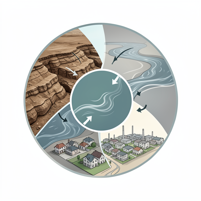
Integrated Spatial Framework for Radiation Risk
AI-generated conceptual illustration (A landscape featuring geological rock formations, a river, and a residential town). It explains the idea and does not show study data.
View source evidence ↗Figures & tables
From the original paper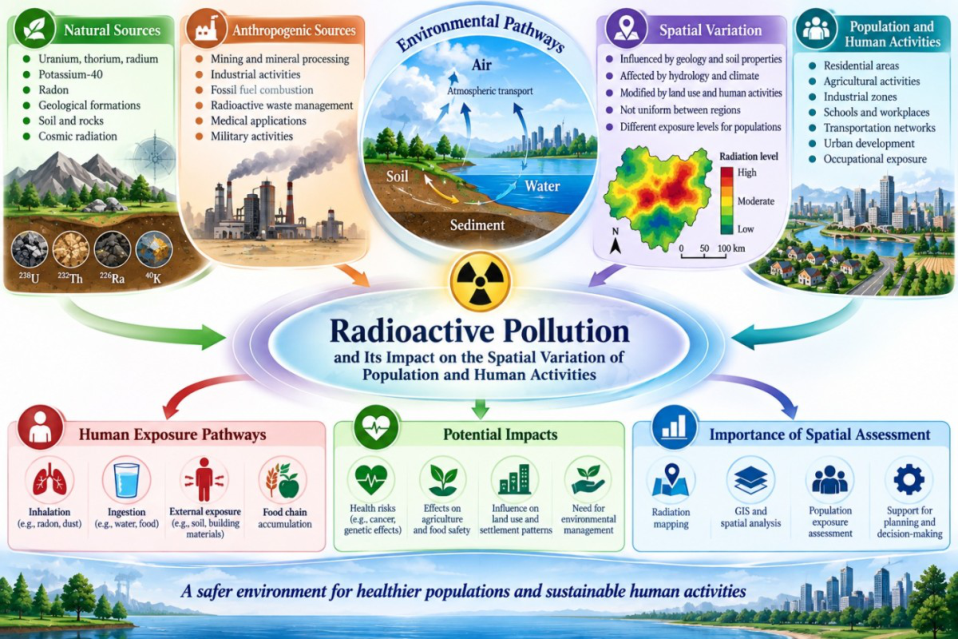 Figure 1
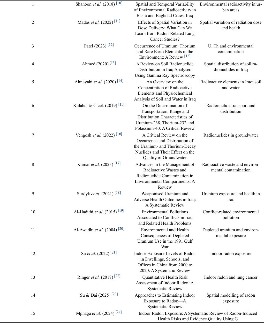 Table 1
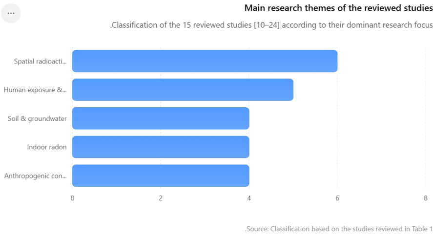 Figure 2
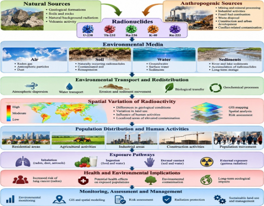 Figure 3
Introduction
Radioactive pollution is an important environmental problem since radionuclides can be retained in soil, water, air, sediments and biological systems and can expose human populations through different pathways. Environmental radioactivity is mainly caused by naturally occurring radionuclides such as uranium-238 (238U), thorium-232 (232Th), radium-226 (226Ra), potassium-40 (40K) and radon-222 (222Rn). Their natural distribution is affected by anthropogenic activities such as mining, industrial operations, fossil-fuel utilization, radioactive-waste management and military activities (UNSCEAR, 2024; UNSCEAR, 2000; UNSCEAR, 1993; UNSCEAR, 2016; IAEA, 2013; IAEA, 2003) [1,2,3,4,5,6] . The spatial distribution of radioactive materials is not uniform and is strongly influenced by geological characteristics, soil properties, hydrological conditions, atmospheric transport, land use and human activities (UNSCEAR, 2000; UNSCEAR, 1993; UNSCEAR, 2016; IAEA, 2013; IAEA, 2003) [2,3,4,5,6] . Therefore, radiation levels may differ significantly from one geographical area to another, resulting in different exposure circumstances for individuals living or working in these areas. And these may be different exposure environments depending on the proximity of the residential communities, agricultural lands, industrial zones, schools and workplaces to the radioactive sources, as well as the pathways of radionuclides transportation. Of particular concern is radon, which can accumulate indoors and is an important source of radiation exposure to the general population. The concentration depends on the geology, permeability of soil, building characteristics, ventilation and geographical conditions (WHO, 2009; WHO, 2023; UNSCEAR, 2006) [7,8,9] . Thus, when evaluating radioactive pollution it is important to take into account not only the concentrations of radionuclides but also their spatial distribution, population density, land use and human activity patterns. The existing literature has studied various aspects of radioactive pollution including radionuclide concentrations in soil and water, environmental transport, indoor radon, occupational exposure and health risks from radiation (UNSCEAR, 2024; UNSCEAR, 2000; UNSCEAR, 1993; UNSCEAR, 2016; IAEA, 2013; IAEA, 2003; WHO, 2009; WHO, 2023; UNSCEAR, 2006) [1,2,3,4,5,6,7,8,9] . However, these results are frequently scattered over different geographical areas and environmental compartments. Hence, a comprehensive review that integrates radioactive pollution with the spatial patterns of population distribution and human activities is needed. Therefore, this review summarizes the previous studies of the sources, spatial distribution, environmental transport, human exposure pathways and potential implications of radioactive pollution for populations and human activities, and highlights the major research gaps and future directions.
Literature Review
Radioactive pollution is a major environmental concern because natural and anthropogenic radionuclides can persist in environmental compartments and be transported through air, soil, water, sediments and biological systems. The spatial distribution of radioactive contaminants is rarely homogeneous as it is influenced by geological characteristics, soil composition, hydrological conditions, atmospheric transport, land use, industrial activities, mining, waste disposal and other human interventions [10,11,12,13,14,15,16,17] . Hence, areas with intensive industrial, agricultural, urban or conflictrelated activities may display different levels of environmental radioactivity compared to less disturbed areas. The knowledge of these spatial variations is essential in determining the potentially contami-nated areas and assessing the extent of radiation exposure of the populations residing or working in the areas. The interrelation between radioactive pollution and the spatial distribution of population and human activities has been attracting increasing attention in environmental and health-related studies. Radionuclides can enter the human body through a variety of pathways, including living areas, workplaces, schools, agricultural lands, industrial facilities and water resources. The extent of human exposure can be influenced by population density and patterns of land use [18,19,20,21,22,23,24] . Previous studies have thus indicated the importance of combining radiation measurements with geographical information, environmental characteristics, population distribution and dominant human activities. Table 1. Comparative review of selected studies on radioactive pollution, radionuclide distribution and radiation exposure and their association with the spatial distribution of populations and human activities. [11] Effects of Spatial Variation in Dose Delivery: What Can We Learn from Radon-Related Lung Cancer Studies? Spatial variation of radiation dose and health 3 Patel (2023) [12] Occurrence of Uranium, Thorium and Rare Earth Elements in the Environment: A Review [12] U, Th and environmental contamination 4 Ahmed (2020) [13] A Review on Soil Radionuclide Distribution in Iraq Analysed Using Gamma Ray Spectroscopy Spatial distribution of soil radionuclides in Iraq 5
Almayahi et al. (2020) [14] An Overview on the Concentration of Radioactive Elements and Physiochemical Analysis of Soil and Water in Iraq Radioactive elements in Iraqi soil and water 6 Kulahci & Cicek (2019) [15] On the Determination of [18] Weaponised Uranium and Adverse Health Outcomes in Iraq:
A Systematic Review Uranium exposure and health in Iraq 10 Al-Hadithi et al. (2015) [19] Environmental Pollutions Associated to Conflicts in Iraq and Related Health Problems Conflict-related environmental pollution 11 Al-Awadhi et al. (2004) [20] Environmental and Health Consequences of Depleted Uranium Use in the 1991 Gulf War Depleted uranium and environmental exposure 12 Su et al. (2022) [21] Indoor Exposure Levels of Radon in Dwellings, Schools, and Offices in China from 2000 to 2020: A Systematic Review Indoor radon exposure 13 Ringer et al. (2017) [22] Quantitative Health Risk Assessment of Indoor Radon: A Systematic Review
Indoor radon and lung cancer 14 Su & Dai (2025) [23] Approaches to Estimating Indoor Exposure to Radon-A Systematic Review Spatial modelling of radon exposure 15 Mphaga et al. (2024) [24] Indoor Radon Exposure: A Systematic Review of Radon-Induced Health Risks and Evidence Quality Using G (continued on next page) The 15 studies reviewed [10,11,12,13,14,15,16,17,18,19,20,21,22,23,24] clearly illustrate a research focus on the spatial distribution of radioactive contamination and its relationship to human exposure. The studies reviewed were divided into those focusing on soil, groundwater and environmental radionuclide distribution, and those looking at indoor radon, uranium exposure, conflict-related contamination and radiation-related health risks. As a whole, the literature shows that spatial variability is repeatedly associated with geological conditions, environmental transport processes, land use, industrial activities, and built environment characteristics. The evidence reviewed here further indicates that population exposure is not only a function of radionuclide concentration but also of the interplay of contamination, location of population, residential and occupational environments and intensity of human activities [10,11,12,13,14,15,16,17,18,19,20,21,22,23,24] . Such a pattern shows that the spatial analysis can be a valuable link between the environmental radioactive pollution and its potential importance for the human populations.
Results and Discussion
The synthesis of the 15 studies reviewed in Table 1 [10,11,12,13,14,15,16,17,18,19,20,21,22,23,24] shows that the radioactive pollution is characterized by a significant spatial variability and this variability is controlled by the interaction of natural environmental conditions and human activities. The reviewed literature consistently indicates geological composition, soil properties, groundwater characteristics, atmospheric transport, land use and anthropogenic disturbance as major controlling factors for the distribution of radionuclides. Therefore, radioactive contamination cannot be sufficiently considered as a homogeneous environmental phenomenon; its degree and importance depend on the geographic location and the nature of the surrounding environment [10,11,12,13,14,15,16,17] . An important finding from the reviewed studies was the spatial variability of naturally occurring radionuclides in soil, rocks, sediments and ground water, especially those associated with uranium, thorium, radium and potassium. Differences among places are associated with variations in geological formations and environmental processes, and human activities can alter the natural patterns [10,13,14,15,16,17] . So close on the map does not mean equal radiation levels. Such variability emphasizes the need for systematic spatial monitoring rather than isolated measurements at sampling points. The studies reviewed also show that radioactive pollution is closely related to human activities. Mining, mineral processing, industrial activities, fossil fuel combustion, waste disposal, construction and other activities can disturb and redistribute naturally occurring radioactive materials in the environment. [12,15,17] . Hence, industrial and highly developed areas may require special consideration as intense human activity may result in additional potential for release of radionuclides and a larger number of people exposed to contaminated environmental media. Agricultural activities may also affect the mobility of radionuclides by soil disturbance, irrigation and transfer of contaminants to crops and food chains. Population exposure is another important pattern that emerged from the literature reviewed. The possible consequences of radioactive contamination depend not only on the concentration of radionuclides, but also on the location and characteristics of the exposed population. Exposure conditions may differ in residential communities, schools, offices, industrial workplaces, agricultural areas and other human environments [18,19,20,21,22,23,24] . People living near contaminated sites may be exposed for long periods of time. Workers may be exposed additionally through direct contact with soil, dust, water or radioactive materials. Therefore, the population distribution should be integrated with the environmental radiation measurements for radiation risk assessment in space. A particularly important example of the relation between geographic conditions and the exposure of populations is indoor radon. The studies reviewed suggest that radon concentrations in buildings can vary considerably due to the variation in the geological conditions, permeability of the soil, building structure, ventilation and location [11,21,22,23,24] .
Figure 3. Integrated Pathway Linking Radioactive Pollution, Spatial Variability, Population Exposure, and Human Activities [14, 15, 16, 17] . This means that the geographical impact of a radioactive source can be wider than the immediate vicinity of the contamination. Radioactive particulates can be transported to agricultural land, residential or other areas of potential human exposure by windblown dust or water movement. Therefore, spatial assessment is necessary to understand the movement and accumulation of radionuclides in environmental systems. The reviewed literature also shows the modern spatial techniques as useful tools to explore those relationships. GIS and spatial interpolation, radiation mapping, geostatistical methods and environmental modeling can be used to find areas with higher radioactivity and proximity to population centers and human activities can be studied. (Madas et al., 2022; Kulahci et al., 2019; Su et al., 2025) [11,15,23] . Radiation measurements in combination with demographic and land-use information can give a more realistic assessment of potential exposure than radiation measurements alone. Such integration is especially helpful when identifying priority areas for monitoring, environmental management and radiation protection interventions. Although the reviewed studies show promising progress, a significant research gap still exists. Previous studies have been limited to a particular radionuclide, environmental medium, geographic location, exposure pathway or health outcome. There are few studies that have combined radioactive pollution, spatial distribution of population, land use and human activities into an analytical framework. This limitation reduces our ability to understand how patterns of environmental radioactivity translate into differences in population exposure and environmental risk across geographic space.The results of this review generally show that radioactive pollution is a spatially dynamic environmental problem, which is influenced by the interaction of radioactive sources, environmental transfer, geographical features, population distribution, and human activities [10,11,12,13,14,15,16,17,18,19,20,21,22,23,24] . Evidence suggests a move away from isolated radiation measurements toward integrated spatial assessments that incorporate environmental radioactivity with demographic, geographic and land use information. Such an approach may enhance the identification of potentially vulnerable populations, improve environmental monitoring and provide a scientific basis for sustainable land-use planning and effective radiationprotection strategies.
Conclusions
Analysis of the literature on radioactive pollution shows that it is a spatially variable phenomenon in the environment and depends on natural and anthropogenic factors. Geological features, the properties of soil and ground water, environmental transport, land use, industrial activities and urban development all contribute to variations in the geographical distribution of radionuclides. The reviewed studies also indicate that population exposure is closely related to the spatial relationship between radioactive sources and residential, agricultural, industrial and occupational environments. Exposure occurs mainly through radon, contaminated soil and water, and uranium-and thorium-bearing materials. The studies in Iraq also stress the need for more attention to be paid to the spatial aspects of areas affected by industrial activities, environmental disturbance and historical conflicts [10, 11, 12, 13, 14, 15, 16, 17, 18, 19, 20, 21, 22, 23, 24] . To summarize, the evidence base is an integrated approach of environmental radiation measurements and GIS, population distribution, land-use information and human activity patterns. Such integration might allow a better identification of potentially vulnerable areas and be a stronger basis for radiation protection, environmental management and sustainable spatial planning.
Recommendations
1. Better spatial monitoring of radiation in residential, industrial, agricultural and potentially contaminated areas to identify areas with increased radioactive levels. 2. GIS and population data are used to locate areas of radioactive contamination that coincide with high population density or high human activity. 3. Enhance indoor radon sur-veillance, particularly in homes, schools, workplaces and in areas with geologic conditions conducive to radon accumulation. 4. Focus on sites in Iraq where contamination is likely, and particularly on those associated with industrial activity, mining, waste disposal and past environmental damage due to conflict. 5. Establish long-term monitoring programs to determine radionuclide concentrations over time and to detect newly introduced contamination. 6. Raise public and professional awareness of pathways of radiation exposures and actions to reduce unnecessary exposures among environmental and health professionals. 7. Encourage inter-disciplinary research for broader assessments of radioactive pollution, integrating environmental radioactivity with geography, demography, GIS, epidemiology and land-use planning.
Figures and tables from the paper
References
25 in the original paper- United Nations Scientific Committee on the Effects of Atomic Radiation (UNSCEAR). Sources, Effects and Risks of Ionizing Radiation: UNSCEAR 2024 Report to the General Assembly, Volume II, Scientific Annex B: Evaluation of Public Exposure to Ionizing Radiation. United Nations, New York; 2024.
- United Nations Scientific Committee on the Effects of Atomic Radiation (UNSCEAR). Sources and Effects of Ionizing Radiation: UNSCEAR 2000 Report to the General Assembly, with Scientific Annexes, Volume I: Sources of Ionizing Radiation. United Nations, New York; 2000.
- United Nations Scientific Committee on the Effects of Atomic Radiation (UNSCEAR). Sources and Effects of Ionizing Radiation: UNSCEAR 1993 Report, Annex A: Exposures from Natural Sources of Radiation. United Nations, New York; 1993.
- United Nations Scientific Committee on the Effects of Atomic Radiation (UNSCEAR). Radiation: Effects and Sources. United Nations Environment Programme (UNEP), Vienna; 2016.
- International Atomic Energy Agency (IAEA). Safety Standards Series: Radiation Protection and Safety of Radiation Sources: International Basic Safety Standards. IAEA, Vienna; 2013.
- International Atomic Energy Agency (IAEA). Extent of Environmental Contamination by Naturally Occurring Radioactive Material (NORM) and Technological Options for Mitigation. Technical Reports Series No. 419, IAEA, Vienna; 2003.
- World Health Organization (WHO). WHO Handbook on Indoor Radon: A Public Health Perspective. WHO, Geneva; 2009.
- World Health Organization (WHO). Radon and Health. WHO, Geneva; 2023.
- United Nations Scientific Committee on the Effects of Atomic Radiation (UNSCEAR). Effects of Ionizing Radiation: UNSCEAR 2006 Report, Volume II, Scientific Annex E: Sourcesto-Effects Assessment for Radon in Homes and Workplaces. United Nations, New York; 2006.
- Shanoon FH, Menkhi SA, Almayahi BA, Dawood AS. Spatial and Temporal Variability of Environmental Radioactivity in Basra and Baghdad Cities, Iraq. Annual Research & Review in Biology. 2018;21(6):1-9.
- Madas BG, Boei J, Fenske N, Hofmann W, et al. Effects of spatial variation in dose delivery: what can we learn from radon-related lung cancer studies? Radiation and Environmental Biophysics. 2022;61:561-577.
- Patel KSK. Occurrence of uranium, thorium and rare earth elements in the environment: A review. Frontiers in Environmental Science. 2023;10:1058053.
- Ahmed RS. A review on soil radionuclide distribution in Iraq analysed using gamma ray spectroscopy. Journal of Environmental Radioactivity. 2020.
- Almayahi BA, et al. An overview on the concentration of radioactive elements and physiochemical analysis of soil and water in Iraq. Journal article/review. 2020.
- Kulahci F, Cicek S. On the determination of transportation, range and distribution characteristics of Uranium-238, Thorium-232 and Potassium-40: A critical review. Environmental Earth Sciences. 2019;78:24.
- A critical review on the occurrence and distribution of the uranium-and thorium-decay nuclides and their effect on the quality of groundwater. Science of the Total Environment. 2022;808:151914.
- Advances in the management of radioactive wastes and radionuclide contamination in environmental compartments: A review. Environmental Geochemistry and Health. 2023;45:2663-2689.
- Surdyk S, et al. Weaponised uranium and adverse health outcomes in Iraq: A systematic review. BMJ Global Health. 2021.
- Environmental pollutions associated to conflicts in Iraq and related health problems. Reviews on Environmental Health. 2015.
- Environmental and health consequences of depleted uranium use in the 1991 Gulf War. Environment International. 2004.
- Su C, Pan M, Zhang Y, et al. Indoor exposure levels of radon in dwellings, schools, and offices in China from 2000 to 2020: A systematic review. Indoor Air. 2022;32:e12920.
- Quantitative Health Risk Assessment of Indoor Radon: A Systematic Review. Radiation Protection Dosimetry. 2017.
- Su C, Dai Y. Approaches to Estimating Indoor Exposure to Radon -A Systematic Review. Atmosphere. 2025;16:286.
- Mphaga KV, Utembe W, Mbonane TP, Rathebe PC. Indoor radon exposure: A systematic review of radon-induced health risks and evidence quality using GRADE approach. Heliyon. 2024;10:e40439.
- How to cite this article: Salman MD. Radioactive pollution and its spatial implications for population distribution and human activities: A comprehensive review. International Journal of Geography, Geology and Environment. 2026;8(9):211-216. doi: https://www.doi.org/10.22271/27067483.2026.v8.i9c.880