
Research article · 2026 · Full text
International Journal of Geography Geology and EnvironmentFrom digital cadastral maps to a digital land data Infrastructure: Updating topological models, LADM, and 3D/digital twin directions for Vietnam
Volume 8(9) · Pages 75–82 · DOI: 10.22271/27067483.2026.v8.i9a.868 ↗
Research areas3D Modeling in Geospatial ApplicationsGeographic Information Systems StudiesLand Use and Management
Abstract
Author-writtenThe digital transformation of land administration requires cadastral systems to evolve from conventional map-based environments toward integrated, interoperable, and lifecycle-oriented land data infrastructures. This study examines the technological and institutional requirements for modernizing Vietnam’s digital cadastre in the context of the 2024 Land Law, Decree No. 101/2024/ND-CP, ISO 19152-1:2024 Land Administration Domain Model (LADM) Edition II, and recent developments in 3D cadastre, Building Information Modelling (BIM), and digital twins. An integrative review and comparative analysis are employed to assess five key dimensions of cadastral data management: object identification, geometric and topological integrity, version and change management, legal-administrative semantics, and interoperability with multidimensional data environments. The results indicate that a modern cadastral infrastructure should combine persistent parcel identification, explicit topological relationships, version-controlled spatial objects, standardized land-administration semantics, and service-based data exchange. In this framework, the Doubly Connected Edge List (DCEL) is suitable as an internal geometric-topological structure for maintaining adjacency relationships, supporting parcel subdivision and amalgamation, validating spatial consistency, and facilitating localized cadastral updates. However, DCEL should operate within the geometry-processing layer rather than serve as a comprehensive land administration data model. LADM provides the conceptual and semantic framework for representing parties, spatial units, basic administrative units, rights, restrictions, responsibilities, legal sources, and object versions. Based on these findings, a six-layer architecture is proposed for Vietnam’s digital cadastral data infrastructure, comprising data acquisition, geometry-topology, land administration semantics, versioning and history, integration and services, and 3D/digital-twin extensions. The proposed architecture provides a technology-neutral pathway for transitioning from conventional digital cadastral maps toward a multipurpose national land data infrastructure capable of systematic updating, historical traceability, inter-agency interoperability, and future integration of three-dimensional property rights and digital-twin applications.
Summary
Source-checkedPlain-language reading of the full paper, prepared with AI and checked against the text. Each point links to the authors' own words.
Why it matters
- Cadastral maps are essential for land administration as they provide the spatial anchor for legal and attribute data, including parcel location, geometry, and area. View evidence ↗
- Vietnam's 2024 Land Law mandates the creation of a centralized and synchronized National Land Information System to enable data sharing across various government levels and sectors. View evidence ↗
- Previous digital mapping efforts in Vietnam were hindered by fragmented software, reliance on proprietary platforms, and difficulties in maintaining topological and attribute consistency during parcel changes. View evidence ↗
The question
- The study aims to determine which parts of a 2015 DCEL-based model remain valid, what needs revision, and how to integrate these with the Land Administration Domain Model (LADM) and 3D/digital-twin technologies. View evidence ↗
What they did
- The authors used an integrative review and policy analysis of sources from 2021-2026, focusing on Vietnamese law, the LADM standard, and research on 3D cadastre, BIM, and digital twins. View evidence ↗
- The analysis evaluated the cadastral system across five dimensions: identity persistence, geometric-topological integrity, temporal traceability, semantic adequacy, and interoperability. View evidence ↗
What they found
- The Doubly Connected Edge List (DCEL) remains useful for maintaining explicit adjacency relationships, which supports parcel subdivision, amalgamation, and topological validation. View evidence ↗
- DCEL is insufficient as a complete land administration model because it lacks domain-specific concepts like legal rights, parties, and temporal validity. View evidence ↗
- The LADM (ISO 19152-1:2024) provides the necessary conceptual framework for representing legal relationships (RRRs), parties, and spatial units, acting as a semantic layer rather than a topological tool. View evidence ↗
- Modern cadastral systems require a temporal component to reconstruct the geometry and legal status of land objects at any specific point in time. View evidence ↗
- Parcel identification must evolve from simple block-level indices to persistent lifecycle identifiers that remain stable regardless of coordinate changes or software formats. View evidence ↗
- While BIM is useful for building geometry, legal rights data must be kept in the land administration model to prevent the physical building model from being mistaken for the legal record. View evidence ↗
What it means
- The proposed architecture serves as a pathway for Vietnam to transition from traditional 2D maps to a multipurpose infrastructure capable of supporting 3D and digital-twin applications. View evidence ↗
- A stated limitation is that the proposed LADM-DCEL prototype has not yet been implemented or benchmark-tested on an actual land database. View evidence ↗
Figures & tables
From the original paper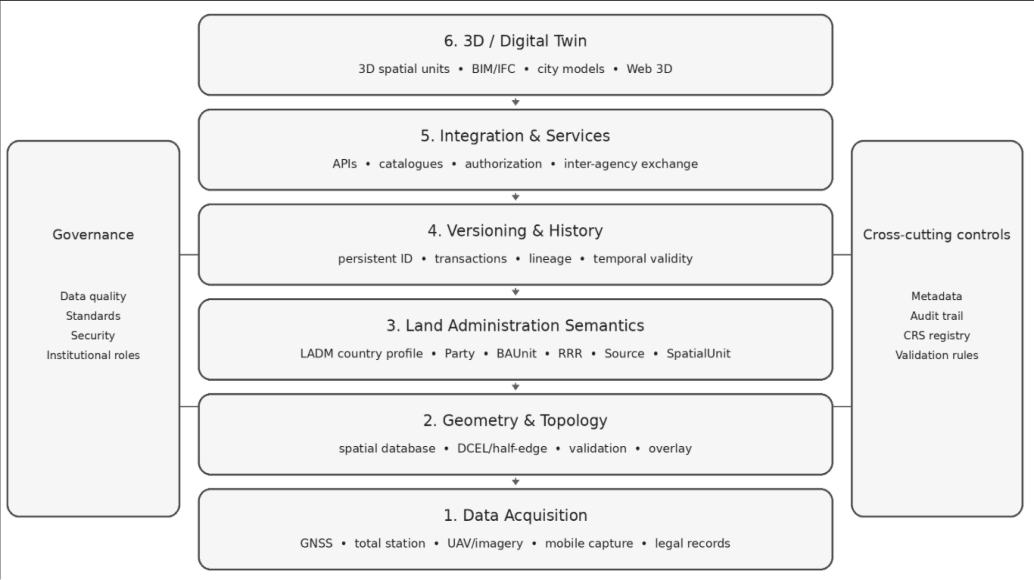 Figure 1
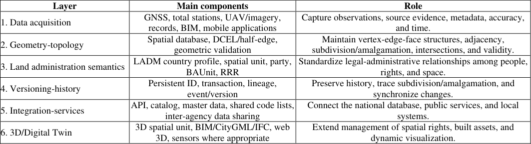 Table 1
Introduction
Cadastral maps constitute a foundational data layer in land administration because they describe the location, geometry, area, and spatial relationships of land parcels while providing a spatial anchor for legal and attribute information. Earlier research on digital cadastral mapping in Vietnam identified fragmented software environments, dependence on proprietary graphic platforms, difficulties in maintaining topology after parcel changes, and weak preservation of attribute linkages when coordinate systems or technical regulations changed. That work proposed specialization of field and office operations, parcel identification by survey block, and the use of DCEL as a data structure for parcel editing, overlay operations, and cadastral updating [1] . More than a decade later, the legal and technological context has changed fundamentally. Vietnam's 2024 Land Law establishes the requirement for a centralized, unified, synchronized, multipurpose National Land Information System capable of connecting and sharing data with national, ministerial, sectoral, and local databases [2] . Decree No. 101/2024/ND-CP further specifies requirements for master data, open data, shared code lists, digital parcel addresses, object uniqueness, and routine updating during administrative procedures [3] . Consequently, the contemporary challenge extends beyond "digital map production" toward lifecycle governance of land data and interoperability among information systems. Internationally, ISO 19152-1:2024 introduced the first part of LADM Edition II, extending the land administration model through standardized concepts for parties, basic administrative units, rights, restrictions and responsibilities (RRRs), spatial units, sources, and versioned objects [4] . At the same time, research on 3D cadastre has expanded rapidly, with increasing attention to multidimensional databases, BIM integration, 3D property formation processes, and digital twins [5][6][7][8][9] . These developments indicate that a contemporary cadastral data model must address three interconnected layers: geometry/topology, legal-administrative semantics, and multidimensional integration and visualization. Against this background, this article addresses three research questions: Which components of the 2015 technological model and DCEL-based structure remain valid under current conditions? Which components require revision? What architecture can connect those principles to LADM, the national land database, and emerging 3D/digital-twin approaches? The objective is to develop an updated framework that preserves the useful contributions of the earlier research without treating them as a complete contemporary system, and instead identifies their appropriate role within a modern digital land administration architecture.
Research basis and Methods
Research basis and Methods
Technical basis from earlier cadastral research
The original study examined workflows for producing digital cadastral maps through direct field surveying, analyzed the limitations of map-sheet-based management, and identified the separation between graphic and attribute data as a major constraint. Three contributions are directly relevant to the present article. First, a unique reference identifier was used to preserve parcel linkage through data transformation. Second, the survey area was divided into parcel blocks and visual information was transferred from field teams to office teams to enable workflow specialization. Third, DCEL was selected to manage vertices, half-edges, faces, and adjacency relationships, thereby supporting algorithms for parcel subdivision and amalgamation, vertex insertion and deletion, polygon overlay, and cadastral record generation [1] . The earlier technical study also developed an experimental software application and tested the proposed algorithms in several surveying projects, including an overlay application for land acquisition and compensation. These results constitute historical empirical evidence for the original research. The present article does not repeat performance testing or conduct new field experiments; therefore, quantitative efficiency claims from the earlier implementation are not extrapolated to contemporary software platforms or infrastructure.
Integrative review method
This article employs an integrative review combined with standards and policy analysis. Updated sources from 2021-2026 are prioritized and grouped into four categories: (i) Vietnamese legislation on land information systems and land databases; (ii) the international LADM standard; (iii) peer-reviewed research on 3D cadastre, cadastral databases, and BIM; and (iv) research on digital twins and technologies supporting data integrity and transparency. The sources are compared according to five criteria: object identification; topology and geometric integrity; version/change management; legal semantics; and interoperability/3D extensibility. This method is appropriate for repositioning an earlier algorithmic structure within a new data-governance ecosystem. It does not substitute for experimental system implementation, but it enables identification of the gap between geometric algorithms and domain-level information models and thereby supports the formulation of an architecture that can be validated in subsequent research.
Analytical framework and assessment dimensions
To make the comparison explicit, the study treats the cadastral system as a set of interacting capabilities rather than as a single database or software package. Five analytical dimensions are used. The first is identity persistence: whether a spatial object can be referenced unambiguously across map re-sheeting, coordinate transformation, subdivision, amalgamation, and institutional data exchange. The second is geometric-topological integrity: whether shared boundaries, adjacency, closure, intersections, overlaps, gaps, and connectivity can be represented and validated without duplicating common edges. The third is temporal traceability: whether the system can preserve predecessor-successor relationships, legal effect dates, source documents, and historical states. The fourth is semantic adequacy: whether the data model can represent parties, basic administrative units, rights, restrictions, responsibilities, spatial units, and sources without encoding legal meaning in graphic labels. The fifth is interoperability: whether the same cadastral objects can participate in web services, national master-data exchange, 3D property representations, BIM/IFC environments, and future digital-twin applications. These dimensions are deliberately separated because weaknesses in one layer should not be compensated for by overloading another layer. A robust topology cannot substitute for legal semantics; conversely, a well-structured LADM country profile does not guarantee geometrically valid parcels. The proposed architecture therefore follows a separation-of-concerns principle in which each layer has explicit responsibilities and interfaces. This provides a clearer basis for subsequent prototype implementation and benchmarking.
The Emerging Context of Digital Cadastre 3.1 From map products to a national land database
The 2024 Land Law provides that the National Land Information System is to be developed in a centralized and unified manner from central to local levels, supporting state administration, administrative reform, and digital transformation while connecting with other databases [2] . The National Land Database comprises the cadastral database together with components relating to land-use planning, land prices, statistics and inventories, land investigation and assessment, and associated datasets. A critical shift is evident: the governing logic has moved from the "map file" to the "shared data object." Decree No. 101/2024/ND-CP further clarifies requirements for master data and digital parcel addresses. Data must be complete, accurate, unique, promptly updated, and shareable [3] . This has important implications for system design: a map-sheet number, parcel number, or graphic label should not serve as the sole technical key throughout an object's lifecycle. Instead, a persistent identifier is required, together with mechanisms for mapping that identifier to operational identifiers used at different times and for retaining the history of changes.
LADM Edition II and the separation of semantic and geometric layers
ISO 19152-1:2024 defines a reference conceptual model for land administration, including packages for parties, administrative units, RRRs, spatial units, sources, and versioned objects [4] . LADM is neither a topological algorithm nor a graphic file format. Its central value lies in providing a common language for representing relationships among people, rights, and space, while allowing countries to develop national profiles that retain their own legal terminology and procedures. Research by Lemmen et al. on the structure of LADM Edition II emphasizes the extension of the model toward broader land administration functions and enhanced support for 3D [6] . The cadastral survey model has also been refined in a technology-neutral manner so that it can accommodate the continuing evolution of GNSS and other surveying methods [7] . This is directly relevant to Vietnam: DCEL can remain useful for geometric and topological operations, but the domain layer should be mapped to a standardized conceptual model rather than requiring topology to simultaneously perform legal identification and attributemanagement functions.
3D cadastre, BIM, and digital twins
The literature review by Gulliver et al. shows substantial growth in 3D cadastral research across legal, technical, registration, and organizational dimensions [5] . A 2024 systematic review of 3D cadastral database systems concluded that most existing cadastral databases remain two-dimensional, whereas high-rise urban development and spatial rights require more effective multidimensional storage, manipulation, and query models [8] . Research in Sweden has proposed a BIM-based 3D property formation process using an Information Delivery Manual, emphasizing lifecycle data exchange among stakeholders [9] . Digital twins extend the requirement from a "static 3D model" toward an "updateable digital counterpart." Mao, van Oosterom, and Rafiee developed an LADM-based digital-twin prototype in which party and rights information can be updated at the backend and reflected through a webbased 3D interface [10] . Such an approach is particularly relevant in complex urban environments where ownership, restrictions, and responsibilities cannot be adequately represented by a single 2D polygon.
Temporal cadastre and event-based updating
A further development in recent land-administration research is the treatment of time as a first-class component of cadastral information. This is particularly important because cadastral objects are not simply edited; they are created, legally activated, superseded, subdivided, amalgamated, corrected, or retired through identifiable administrative events. Recent work on LADM-based 3D temporal cadastres demonstrates the value of combining spatial units with temporal attributes for environments in which boundaries and jurisdictional extents change over time [15] . Although coastal cadastre presents a specialized case, the underlying principle is general: a cadastral system should be able to reconstruct what object existed, under which geometry and legal status, at a particular time. For Vietnam, an event-based model would complement the current emphasis on prompt database updating by ensuring that each accepted change is associated with a transaction identifier, source document, effective date, responsible authority, affected spatial units, and resulting object versions. This approach supports auditability and dispute resolution while also reducing the temptation to overwrite operational records. It is therefore closely related to persistent identification and should be implemented jointly with parcel lineage rather than as an optional archival function.
Reassessment of the core solutions 4.1 Unique parcel identification: from reference index to lifecycle identifier
The 2015 proposal used a unique parcel index to link spatial and attribute data and preserve information during coordinate transformation [1] . This principle is consistent with current requirements for object uniqueness and digital parcel addressing [3] . However, it should be upgraded from a "block-level management index" to a persistent lifecycle identifier. Such an identifier should be independent of the coordinate reference system, map sheet, or software format; when parcels are subdivided or amalgamated, newly created objects should receive new identifiers while retaining lineage relationships to their source objects. A lifecycle-based approach addresses a key limitation of the map-sheet/parcel-number system: operational identifiers can change through revision, re-sheeting, or data reorganization, whereas interoperable systems require a stable reference key. From a design perspective, three identifier layers can be maintained in parallel: a system identifier; a cadastral identifier with operational and legal significance; and a digital-address/inter-agency sharing key. Separating these layers reduces the risk of overloading a single data field with multiple functions.
Specialization of field and office operations: From file transfer to a collaborative digital workflow
Earlier work proposed transmitting survey observations and sketch images from the field to the office, thereby allowing workforce specialization and parallel processing [1] . Under current conditions, this principle can evolve into a servicebased collaborative workflow: surveying instruments/GNSS or mobile applications record observations and field evidence; data are synchronized to an intermediate repository; automated quality-control engines detect geometric errors; office staff perform editing; and results are returned to the field for validation. A significant change is that "visual information" should no longer exist only as photographs of field sketches. It can be structured as source evidence containing time, data collector, equipment, accuracy, images, digitally signed documents, and links to spatial objects. This organization is more consistent with the source-and versioned-object concepts of LADM [4] and improves traceability in cases of dispute or cadastral revision. Compared with a spaghetti model, DCEL reduces ambiguity in shared boundaries and provides a robust basis for localized editing operations [1] . However, DCEL should not be treated as the comprehensive data model of a modern land administration system. It does not contain domain concepts such as parties, rights, restrictions, responsibilities, legal sources, temporal validity, or object versions. Its appropriate position is therefore the core geometric/topological layer, or an internal indexing and editing structure within a spatial service. Domain objects above this layer refer to spatial units; change history is managed through versioning or event sourcing; and DCEL ensures geometric validity and adjacency relationships within each version.
Polygon overlay: from cartographic operation to analytical service
The DCEL overlay algorithm in the original research split edges at intersections, constructed closed faces, and preserved attributes when new polygons were created [1] . The underlying principle remains important for compensation and land acquisition, planning, protection corridors, land-use restrictions, and intersection analysis. In a contemporary architecture, however, overlay operations should be encapsulated as analytical services with controlled versioning, coordinate reference systems, and accuracy constraints rather than being executed directly on operational map files. Service encapsulation also allows the algorithm to be selected according to scale: DCEL for local topological editing, spatial databases for large-area queries, and parallelprocessing tools for large datasets. This enables reuse of the original algorithmic logic without locking the system into a single data structure.
Proposed architecture for Vietnam's digital cadastral data infrastructure
By comparing earlier cadastral research with current legal requirements and international developments, this article proposes a six-layer architecture. The architecture is independent of any particular software product and can be implemented through a centralized service model combined with local nodes. As illustrated in Figure 1, the proposed architecture connects data acquisition, geometrictopological processing, LADM-based land administration semantics, version and history management, interoperable services, and 3D/digital-twin extensions within a unified framework. The principal components and functional roles of the six architectural layers shown in Figure 2 are further summarized in Table 1. As summarized in Table 1, the six layers are functionally distinct but mutually dependent: the lower layers ensure reliable data acquisition and geometric-topological integrity, whereas the upper layers provide semantic consistency, lifecycle management, interoperability, and future extensibility toward 3D cadastre and digital-twin applications.
Geometry-topology layer
This layer is responsible for geometric quality and is not tightly coupled to legal procedures. DCEL can be used within the editing engine to ensure that adjacent parcels share a single logical boundary, detect dangling/intersecting edges, and perform localized subdivision and amalgamation. Once a transaction is committed, the valid topological state is stored in the spatial database. This approach exploits the strengths of DCEL while allowing it to be replaced or complemented by 3D half-edge structures, boundary representations, or other database structures as the system evolves.
LADM semantic layer
LADM is used as a reference conceptual model to distinguish the "parcel visible on the map" from the "spatial unit associated with a right." A 2D parcel may correspond to one or more spatial units; in multi-level developments, a right may relate to a 3D volume. A Vietnamese country profile should map domestic legal concepts to LADM classes without losing national legal terminology. Experience from the 2024 LADM country-profile study for Pakistan indicates that the model can support a transition from manual records to 2D/3D environments and help identify institutional overlaps, but requires expert consultation and adaptation to national law [11] .
Versioning and history layer
Every cadastral revision should be treated as a transaction with an identifiable source, time, and predecessor-successor relationship. Parcel subdivision creates new spatial units; amalgamation creates a new object; previous objects move to a historical state rather than being physically deleted. This is essential for accurate and timely updating and for auditability. It also reduces dependence on "rebuilding topology for the entire map," which earlier cadastral research identified as a cause of broken attribute linkages [1] .
Transaction semantics and parcel lineage
The transaction layer should distinguish between geometric change, administrative change, and legal change. A boundary correction may create a new geometry version without changing the underlying right holder; a transfer may modify RRR relationships while the geometry remains unchanged; subdivision and amalgamation can affect both geometry and legal units. Treating these cases explicitly prevents the common database practice of using a single "last updated" field to represent fundamentally different events. It also enables validation rules to be tailored to transaction type. Parcel lineage should be modelled as a directed predecessorsuccessor graph. Each active object has a persistent identifier and one or more versions, while retired objects remain queryable for historical reconstruction. For subdivision, one predecessor may have several successors; for amalgamation, several predecessors may lead to one successor. The graph can also include correction events, annulments, and administrative renumbering. This design is compatible with LADM versioned-object concepts and provides a practical bridge between topological editing and legal-historical traceability.
Integration and services layer
Under Decree No. 101/2024/ND-CP, the land database is expected to contain master data, open data, shared code lists, digital addresses, and data for connection and sharing [3] . APIs and data catalogs should therefore be treated as architectural components rather than add-on utilities. Minimum services should include object queries by identifier, retrieval of historical versions, topological validation, coordinate reference system transformation, access to data by spatial extent and authorization level, and registration of change events. Access control should distinguish public-viewing rights, professional operational rights, and authority to perform legally effective updates.
3D and digital-twin layer
Not every locality requires an immediate transition to 3D cadastre. Priority should be given to areas containing condominiums, underground structures, mixed-use complexes, spaces above or below ground, or overlapping spatial rights. A 2024 review of 3D cadastral databases found that no single solution currently satisfies all storage, manipulation, and retrieval requirements, suggesting that modular architecture is necessary [8] . BIM can supply building geometry and semantics, but rights data should remain governed within the land administration model to avoid conflating a building model with the legal record [9] . A digital twin constitutes a subsequent development when data can be dynamically updated and visualized [10] .
Data governance, quality assurance, and interoperability controls
A national land data infrastructure cannot rely solely on a technically sound schema; it also requires enforceable governance rules. At minimum, governance should define authoritative data custodians, update responsibilities, validation thresholds, metadata obligations, access-control levels, and procedures for resolving conflicts between central and local datasets. The geometry layer should apply automated rules for gaps, overlaps, self-intersections, duplicate vertices, dangling edges, invalid rings, and tolerance violations. The semantic layer should validate mandatory relationships among parties, RRRs, BAUnits, sources, and spatial units. The temporal layer should reject transactions that create inconsistent validity intervals or break lineage chains. Interoperability should likewise be managed through explicit contracts. APIs need stable object identifiers, version parameters, coordinate reference system declarations, response schemas, and authorization scopes. Exchange services should expose only the attributes required for the intended purpose and should record provenance so that downstream agencies can identify the authoritative source and update time. This is particularly important when cadastral data are consumed by taxation, planning, construction permitting, infrastructure management, disaster management, or public-service platforms. Quality assurance should therefore combine three forms of control: automated validation before transaction submission, professional review for geometrically or legally complex cases, and post-commit audit using immutable logs. This layered approach allows routine changes to be processed efficiently while preserving a higher level of scrutiny for transactions that may affect legal boundaries or overlapping 3D rights.
Discussion 6.1 Continuing relevance of the DCEL research in the 2026 context
The most enduring contribution of the earlier technical study lies not in the programming language or in a particular experimental application, but in three design principles: managing topological relationships rather than storing disconnected geometries; maintaining a persistent reference key between spatial and attribute data; and organizing workflows so that field data can be processed by specialized office teams without losing contextual information. These principles remain compatible with modern data architectures and can be regarded as technical foundations for versionedobject management. Conversely, several components are outdated if applied without modification: reliance on KML/Google Earth as the primary field-validation channel; monolithic desktopapplication design; treating graphic files as the center of the system; and performance optimization tied to a particular programming language or data type. New systems should prioritize spatial databases, web services, automated testing, version management, and open standards.
DCEL and LADM are complementary rather than substitutive
A common conceptual error is to place a topological structure and a land administration domain model at the same level. DCEL answers the question, "How are vertices, edges, and faces connected?" LADM answers, "Which party holds which right, restriction, or responsibility over which spatial unit, based on what source and in which version?" Proper integration therefore maps an LADM spatial unit to a geometric/topological representation managed by a spatial engine. When geometry changes, a topological transaction creates a new version of the spatial unit, while RRR relationships are carried forward or re-established through the applicable legal procedure.
Implications for Vietnamese data standards
Future data standards should explicitly distinguish three levels: conceptual model, logical exchange model, and physical implementation model. If a standard describes only layers, files, and symbols, systems risk reproducing the earlier condition of software dependency. Conversely, an excessively prescriptive physical schema will become obsolete quickly. The LADM approach allows semantic stability at the conceptual level while exchange formats and storage technologies can evolve independently.
Security, transparency, and distributed-ledger technologies
Recent studies continue to consider blockchain as a potential mechanism for improving the verifiability of land transactions, but not as a substitute for a cadastral database. A 2022 study of blockchain-based land management emphasized its potential for transparency and integrity while also questioning implementation feasibility and practical value [12] . For Vietnam, immediate priorities should be robust identification, versioning, digital signatures, immutable audit logs, and authorization controls. Blockchain should be considered only for inter-agency use cases in which distributed trust demonstrably creates additional value.
Interoperability between 2D topology, LADM, BIM, and digital twins
The transition toward 3D does not imply that 2D cadastral topology becomes obsolete. Most land parcels, administrative boundaries, and many legal procedures will continue to rely on planar representations. The implementation challenge is therefore one of coexistence: 2D parcel topology must remain authoritative where appropriate, while selected spatial units can be extended into 3D volumes. LADM provides the semantic bridge because the same party-RRR-spatial unit relationships can reference different geometric realizations according to the legal situation and level of detail. BIM should be treated as a source and visualization environment for physical building components rather than as the sole legal record. Research linking LADM and IFC has shown that legal concepts can be associated with BIM entities to improve understanding of ownership spaces in multi-storey buildings [16] . In operational systems, however, the cadastral authority still needs a controlled landadministration representation that is independent of any particular authoring model. A practical architecture therefore stores legal identity, RRRs, sources, versions, and authoritative spatial-unit references in the landadministration environment while using BIM/IFC and city models for detailed geometry and physical context.
Digital twins add another layer of complexity because they may contain frequently changing operational information from buildings, infrastructure, or sensors. Only a small subset of those changes has cadastral significance. The integration interface must therefore separate dynamic contextual data from legally effective land-administration transactions. This separation reduces unnecessary update loads and protects the legal stability of the cadastre while still allowing planners, engineers, and citizens to visualize property rights in a richer three-dimensional context. The continuing international focus on LADM and 3D land administration confirms that this coupling of semantic stability with richer spatial representation is becoming a central research direction [14] .
Research and implementation roadmap
The proposed architecture supports a four-stage roadmap.
References
15 in the original paper- National Assembly of Vietnam. Land Law No. 31/2024/QH15 (effective-date provisions amended and supplemented by Law No. 43/2024/QH15). Vietnam: National Assembly of Vietnam; 2024. (In Vietnamese).
- Government of Vietnam. Decree No. 101/2024/ND-CP dated 29 July 2024 on fundamental land investigation; land registration and issuance of certificates of land-use rights and ownership of land-attached assets; and the Land Information System. Vietnam: Government of Vietnam; 2024. (In Vietnamese).
- International Organization for Standardization. ISO 19152-1:2024 Geographic information-Land Administration Domain Model (LADM)-Part 1: Generic conceptual model. Geneva: International Organization for Standardization; 2024.
- Paasch JM, Paulsson J. Trends in 3D cadastre-A literature survey. Land Use Policy. 2023;131:106716. doi:10.1016/j.landusepol.2023.106716.
- Kara A, Lemmen C, van Oosterom P, Kalogianni E, Alattas A, Indrajit A. Design of the new structure and capabilities of LADM edition II including 3D aspects. Land Use Policy. 2024;137:107003. doi:10.1016/j.landusepol.2023.107003.
- Kalogianni E, Dimopoulou E, Gruler HC, Stubkjaer E, Morales J, Lemmen C, et al. Refining the survey model of the LADM ISO 19152-2: Land registration. Land Use Policy. 2024;141:107125. doi:10.1016/j.landusepol.2024.107125.
- Shahidinejad J, Kalantari M, Rajabifard A. 3D cadastral database systems-A systematic literature review. ISPRS Int J Geo-Inf. 2024;13(1):30. doi:10.3390/ijgi13010030.
- Sun J, et al. A BIM-based approach to design a lifecycle 3D property formation process: A Swedish case study. Land Use Policy. 2023;131:106712. doi:10.1016/j.landusepol.2023.106712.
- Mao P, van Oosterom P, Rafiee A. A digital twin based on Land Administration. In: Proceedings of the 12th International FIG Workshop on the Land Administration Domain Model & 3D Land Administration. International Federation of Surveyors; 2024. p. 243-258.
- Ahsan MS, Hussain E, Lemmen C, Chipofya MC, Zevenbergen J, Atif S, et al. Applying the Land Administration Domain Model (LADM) for integrated, standardized, and sustainable development of cadastre country profile for Pakistan. Land. 2024;13(6):883. doi:10.3390/land13060883.
- Racetin I, Kilić Pamuković J, Zrinjski M, Peko M. Blockchain-based land management for sustainable development. Sustainability. 2022;14(17):10649. doi:10.3390/su141710649.
- Hassan W, Munir I, Yue S, Ahmed W, Mousa BG. Digital cadastral land information system for enhanced land management in Pakistan. J Build Des Environ. 2024;2:23956. doi:10.37155/2811-0730-0301-1.
- van Oosterom P, Kara A, Kalogianni E. Land administration domain model and 3D land administration. Surv Rev. 2025;57(405):509-511. doi:10.1080/00396265.2025.2561263.
- Atulukwu YH, Hassan MI, Abdul Rahman A. 3D temporal approach for coastal cadastre based on LADM. Surv Rev. 2025;57(405):539-554. doi:10.1080/00396265.2025.2544401.
- Atazadeh B, Olfat H, Rajabifard A, Kalantari M, Shojaei D, Marjani AM. Linking Land Administration Domain Model and BIM environment for 3D digital cadastre in multi-storey buildings. Land Use Policy. 2021;104:105367. doi:10.1016/j.landusepol.2021.105367.