
Research article · 2026 · Full text
International Journal of Geography Geology and EnvironmentSpatial analysis of natural radioactivity in agricultural soils Kufa city and its relation with geomorphological units east of Euphrates River by using remote sensing and geographic information systems (GIS)
Volume 8(9) · Pages 65–74 · DOI: 10.22271/27067483.2026.v8.i9a.867 ↗
Research areasRadioactivity and Radon MeasurementsGeochemistry and Geologic MappingHeavy metals in environment
Abstract
Author-writtenThe problem of natural radioactivity in agricultural soils is an important environmental problem because the naturally occurring radionuclides may contribute to radiation exposure and enter into the food chain. In this study, the 00004concentrations of naturally occurring radionuclides in agricultural soils collected east of Euphrates River in Kufa City, Iraq were determined. Sixty soil samples were collected systematically from different agricultural sites, along with their geographical coordinates. Prior to the gamma-ray spectrometric analysis the samples were dried, crushed, homogenized and sieved. The activity concentrations of 238U, 232Th and 40K were determined by NaI(Tl) gamma-ray spectrometry system by looking at the proper calibration procedures. The results showed a spatial variability in the concentrations of radionuclides in the analyzed samples. The activity concentrations of 2 3 8U ranged from 18.65 to 29.68 Bq kg−1 with a mean of 23.87 Bq kg−1 For 2 3 2The Th concentrations varied from 23.48 to 37.12 Bq kg-1 with an average value of 29.72 Bq kg-1. Maximum activity concentrations were determined in ⁴⁰K and were in the range of 271.4-419.4 Bq kg⁻¹ with a mean of 350.8 Bq kg⁻¹. The variations observed can be explained by the differences in the soil composition, the mineralogical properties and the local environmental conditions. A comparison with the adopted reference values of 33 Bq kg-1 for 238U, 45 Bq kg-1 for 232Th and 420 Bq kg-1 for 40K revealed that the average concentrations of all investigated radionuclides were lower than the corresponding reference levels. The overall results indicate normal levels of natural radioactivity in the investigated agricultural soils and the measured radionuclides did not indicate any significant radiological concern. The present study provides baseline data that can be used in supporting future environmental monitoring and radiological assessment of agricultural soils in Kufa city.
Summary
Source-checkedPlain-language reading of the full paper, prepared with AI and checked against the text. Each point links to the authors' own words.
Why it matters
- Natural radioactivity in agricultural soils is a significant environmental concern because radionuclides can enter the food chain and lead to radiation exposure. View evidence ↗
- Evaluating radionuclide concentrations in soil is essential for determining the natural radiological background of a region, as soil acts as a primary reservoir for these materials. View evidence ↗
- Standard assessments using only mean activity concentrations fail to capture geographical variability, making spatial analysis necessary to identify specific high and low concentration areas. View evidence ↗
The question
- The study aims to determine the spatial distribution of uranium-238, thorium-232, and potassium-40 in agricultural soils east of the Euphrates River in Kufa City. View evidence ↗
- The researchers sought to investigate how radionuclide concentrations relate to the main geomorphological units using GIS and remote sensing. View evidence ↗
What they did
- Sixty soil samples were systematically collected from various agricultural sites, with each site's geographical coordinates recorded. View evidence ↗
- A thallium-doped sodium iodide (NaI(Tl)) gamma-ray spectrometry system was used to measure the activity concentrations of the three radionuclides. View evidence ↗
- The study integrated GPS coordinates into a GIS database to analyze the spatial distribution of radionuclides and their relationship to geomorphological units. View evidence ↗
What they found
- Uranium-238 concentrations ranged from 18.65 Bq kg⁻¹ (sample KS-50) to 29.68 Bq kg⁻¹ (sample KS-41), with a mean of 23.87 Bq kg⁻¹. View evidence ↗
- Potassium-40 showed the highest activity, ranging from 271.4 Bq kg⁻¹ (sample KS-50) to 419.4 Bq kg⁻¹ (sample KS-41), with a mean of 350.8 Bq kg⁻¹. View evidence ↗
- The observed activity trend (K-40 > Th-232 > U-238) aligns with the typical natural composition of terrestrial soils. View evidence ↗
- Spatial variability was evident, with higher activities concentrated in samples KS-31 to KS-45 and lower values in samples KS-46 to KS-52. View evidence ↗
What it means
- The study provides essential baseline data to support future radiological assessments and environmental monitoring of agricultural soils in the region. View evidence ↗
Visual summary
1 visualsIllustrations explain the paper; charts are replotted from the paper's own table values.
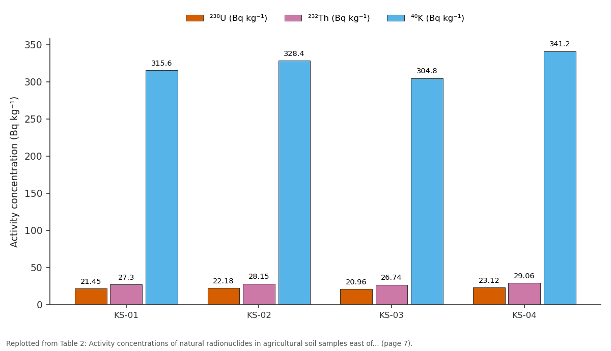
²³⁸U (Bq kg⁻¹) and ²³²Th (Bq kg⁻¹) and more: KS-01 vs KS-02 vs KS-03 vs KS-04
Replotted from Table 2 (page 7) of the original paper. Every bar is the paper's own table value.
View source evidence ↗Figures & tables
From the original paper Table 1
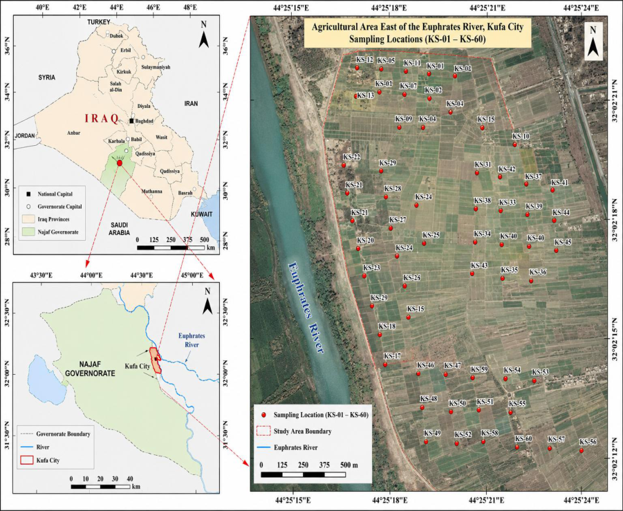 Figure 1
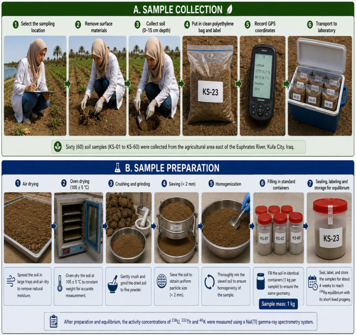 Figure 2
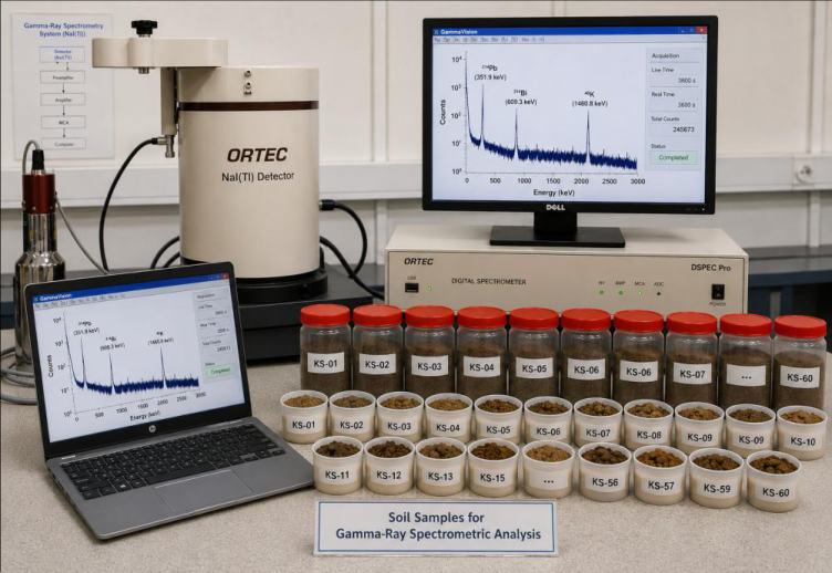 Figure 3
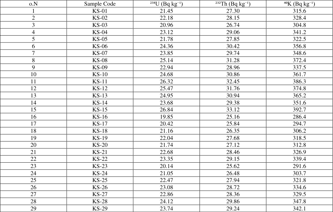 Table 2
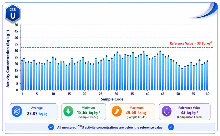 Figure 3
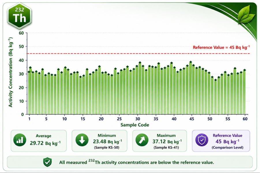 Figure 4
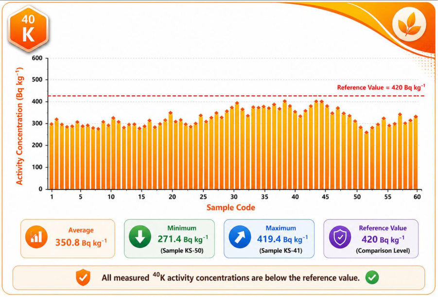 Figure 5
Introduction
Natural radioactivity is an intrinsic component of the terrestrial environment and is mainly associated with primordial radionuclides, particularly uranium-238 (²³⁸U), thorium-232 (²³²Th) and potassium-40 (⁴⁰K). These radionuclides are naturally present in rocks, sediments and soils, and their concentrations depend on geological composition, parent materials, mineralogy, weathering and sedimentary processes [1,2] . The soil is an important environmental reservoir for natural radionuclides and is a major contributor to terrestrial gamma radiation, therefore, the evaluation of their concentrations is important when trying to determine the natural radiological background of an area [1,3] .The spatial distribution of ²³⁸U, ²³²Th and ⁴⁰K in soils is generally heterogeneous due to the influence of different environmental and geochemical processes on each radionuclide. Uranium and thorium are related to certain minerals and fine soil fractions, while 40K is primarily associated with potassium-bearing minerals such as feldspars, micas, and clay minerals [2,4] . Hence, variations in soil texture, mineral composition, weathering, erosion and sediment transport can produce large differences in natural radioactivity over relatively short distances [2,5] . In particular, the study of such variations is of great importance for agricultural soils in fluvial environments. Rivers are in a state of constant motion, sorting and depositing sediments from many different geologic sources. Erosion, flooding, sediment transport and alluvial deposition by the Euphrates River have been important in the formation of the landscape around Kufa City. These long-term processes have led to the formation of a variety of geomorphological environments like alluvial plains, floodplain deposits, natural levees and other sedimentary units with varying textures, mineral compositions and depositional histories. These differences may directly affect the distribution of uranium, thorium and potassium in agricultural soils [2,5] .Many studies have been conducted on the natural radioactivity in soils, however, the traditional assessments that are solely based on mean activity concentrations are not sufficient to consider the geographical variability of radionuclides. Therefore spatial analysis is needed to identify areas of relatively high and low concentrations and to study environmental factors controlling their distribution. Geographic Information Systems (GIS) are efficient tools for the integration of the radionuclides measurements with the data coordinates of the sampling and the environment, allowing the development of continuous maps of the spatial distribution through the use of interpolation techniques and facilitating a more complete interpretation of the radioactivity patterns. [3,6] .Remote sensing complements this approach by providing spatial information on land-cover conditions, vegetation, soil surfaces, moisture and geomorphological characteristics. Data and indices derived from satellites can be combined with GIS to describe the environmental setting of agricultural lands and to aid in the interpretation of spatial differences in radionuclide concentrations. In addition, the identification of geomorphological units provides a significant framework for understanding whether differences in natural radioactivity are correlated with sedimentary origin and landscape evolution [5,7] .The simultaneous determination of ²³⁸U, ²³²Th and ⁴⁰K is of particular importance as these radionuclides may exhibit different spatial behaviors. The joint study of them can provide useful information on the geological and environmental processes that affect the radioactivity of the soil. In addition, the measured activity concentrations can be used to estimate the radiological hazard parameters and set a baseline for future environmental monitoring [1,3] .Hence, the present work aims to study the spatial distribution of natural radioactivity in agricultural soils east of Euphrates River, Kufa City by measuring the activity concentrations of 238U, 232Th and 40K. The study combines field measurements with Remote Sensing and Geographic Information Systems (GIS) to produce spatial distribution maps and to investigate the relationship between radionuclide concentrations and the main geomorphological units. This integrated approach is expected to provide a better understanding of natural radioactivity controls by environmental and geomorphological factors and to assist in the construction of a complete radiological baseline for the agricultural soils of the study region.
Study Area
The present study was conducted in the agricultural areas lying to the east of Euphrates River inside and around Kufa City, Al-Najaf Governorate, central Iraq. Kufa is located in a significant section of the Euphrates River basin where a large number of agricultural areas have been developed on alluvial deposits which the river has transported and laid down over a long period of time. The study area is characterized by a predominantly flat topography and an agricultural landscape shaped by irrigation, seasonal cultivation and the constant interaction between soil and river processes. The soils of the study area are largely associated with alluvial sediments which may vary in their texture, grain size, mineral composition and depositional history. The Euphrates River has had a great influence on the geomorphological features of this region by erosion, sediment transport, flooding and deposition. These processes have produced several geomorphological units such as alluvial plains, floodplain deposits, natural levees and other fluvial landforms. Such changes of geomorphological conditions can affect the distribution of naturally occurring radionuclides in agricultural soils. The region's climate is generally characterized by hot and dry conditions, with high temperatures during summer and relatively limited precipitation. The main source of irrigation water for agricultural activities is the Euphrates River and its related irrigation networks. The constant use of agricultural land and natural sedimentary processes makes this location suitable for the study of the spatial behavior of uranium-238 (238U), thorium-232 (232Th) and potassium-40 (40K).The location east of the Euphrates River was chosen based on the importance of the environment and agriculture and the possibility of the influence of geomorphological variability on soil characteristics. In this study, soil samples were collected from spatially distributed agricultural locations to represent the variability of study area. All sampling sites were geo-referenced and entered into a Geographic Information System (GIS) database. The spatial database was used to analyze and spatialize the distribution of the measured radionuclides and to investigate the relationship with the identified geomorphological units. Remote sensing data were also used to obtain spatial information on the characteristics of the study area and to assist in the delineation and interpretation of land-surface and geomorphological features. The integration of field measurements, geomorphological data, remote sensing and GIS offers a complete framework to assess the spatial variation of natural radioactivity in agricultural soils east of the Euphrates River. All sample sites were geo-referenced with the Global Positioning System (GPS) and imported into a Geographic Information System (GIS) database. The sampling sites distribution is a spatial framework for the mapping and analysis of the concentrations of the radionuclides under investigation and the relationship with the local geomorphological characteristics. Table 1. The geographical coordinates and sample codes of the 60 agricultural soil sampling sites used in this study. Therefore, the collected samples represent an important environmental data set for the assessment of natural radioactive background of agricultural soils in the east of the Euphrates River and for the investigation of possible correlations between the distribution of radionuclides, sedimentary conditions and geomorphological units.
| S. No. | Sample Code | Latitude (N) | Longitude (E) |
|---|---|---|---|
| 1 | KS-01 | 32°02′19.79376756″ | 44°25′17.23349388″ |
| 2 | KS-02 | 32°02′19.48081812″ | 44°25′18.98948784″ |
| 3 | KS-03 | 32°02′19.11571044″ | 44°25′19.77186144″ |
| 4 | KS-04 | 32°02′18.75060276″ | 44°25′20.60639328″ |
Table text extracted from the original PDF; superscript letters are shown inline. The original table image is below.
View original table image
Sample Preparation
All soil samples were collected, transported to the laboratory and processed through a standard preparation protocol prior to analysis by gamma-ray spectrometry. The sample preparation plays an important role in the measurements of natural radioactivity, since the moisture content, the particle size, the homogeneity of the sample and the differences in the counting geometry may influence the accuracy and reproducibility of the measured gamma-ray spectra. Therefore, all the 60 agricultural soil samples were prepared using the same procedure to maintain the measurement condition. The samples were initially dispersed individually on clean and dry surfaces to decrease the natural moisture of the samples. Samples were then dried to a stable and sufficiently dry state under controlled conditions. Drying was carried out to minimize the effect of variable soil moisture and to allow consistent reporting of radionuclide concentrations on a dry-mass basis. Each sample was then gently crushed and ground after drying to break down aggregates and to obtain a more homogeneous material. The samples were then thoroughly mixed to ensure homogeneity because natural radionuclides may not be uniformly distributed in untreated soil. The homogenized soil was then sieved to remove coarse particles, stones, roots and other undesired materials. This step produced a relatively homogeneous grain-size fraction suitable for reproducible gamma-ray spectrometric measurements. The prepared samples were then placed into standardized measurement containers of identical geometry. When using a NaI(Tl) gamma-ray spectrometry system it is particularly important to measure all the samples in the same container size, sample geometry and filling conditions as the detection efficiency depends on the geometry and physical arrangement of the sample relative to the detector. Samples were filled, sealed and labeled with the sample code for each container. The sealed samples were kept for an appropriate time before measurement in an effort to establish secular radioactive equilibrium between radium-226 (226 Ra) and its short-lived decay products especially when the indirect determination of the uranium series was based on gamma emissions from the daughter radionuclides.
Once the samples were prepared and the equilibration period was over, the radiological analysis could take place.
Then activity concentrations of 238U, 232Th and 40K were measured by a thallium-doped sodium iodide (NaI(Tl)) gamma-ray spectrometry system. Prior to the sample measurements, the spectrometry system was properly energy-calibrated and efficiency-calibrated using appropriate reference sources and standard procedures. All soil samples were measured with the same counting geometry and experimental conditions in an effort to make the results comparable. The measured gamma-ray spectra were analyzed to identify the characteristic energy peaks of the investigated natural radionuclides and their decay products from which the activity concentrations were derived. The 60 agricultural soil samples were prepared under comparable conditions by following a standardized procedure (drying, homogenization, sieving, sealing, equilibration, and gamma-ray measurement). Thus, the collected radiological data could be reliably integrated with GPS coordinates and GIS environment for later statistical analysis, spatial interpolation and assessment of the relationship between natural radioactivity and the geomorphologic units of the agricultural area east of the Euphrates River.
Gamma-Ray Spectrometric Measurements Using NaI(Tl)
The prepared samples of agricultural soil were analyzed using thallium-activated sodium iodide [NaI(Tl)] gammaray spectrometry. The NaI(Tl) detector is a scintillation detector. The incident gamma photons interact with the crystal to produce flashes of light proportional to the deposited energy. These light signals are converted into electrical pulses and then processed by the corresponding electronic system and multichannel analyzer to obtain the gamma-ray energy spectrum. The NaI(Tl) detector is widely used for the determination of naturally occurring radionuclides, including the uranium and thorium decay series and potassium-40 [8,9] , due to its relatively high detection efficiency, suitability for environmental measurements and ability to record gamma radiation over a wide energy range.The gamma-ray spectrometry system was energy-calibrated with suitable standard gamma-emitting reference sources of well-defined photon energies before measuring the soil samples. The channel number versus gamma ray energy relationship was found to be able to properly identify the characteristic photopeaks in the measured spectra. Repeated measurements of appropriate reference sources were also used to verify the stability and the energy resolution of the system, since proper calibration is necessary for accurate peak identification and reliable radionuclide determination [8] .Efficiency calibration was also done to relate the detector efficiency to the gamma-ray energy. This calibration was done using appropriate reference materials or standard sources counted under the same counting geometry as the soil samples investigated. Since the gamma-ray detection efficiency depends on the source geometry, sample density, matrix composition and photon energy [8,10] , it is important to keep the same sample containers, sample geometry and measurement conditions. The use of certified reference materials and standard calibration procedures also improves the accuracy, comparability and quality assurance of environmental radioactivity measurements [11] .Each sealed soil sample was positioned at a fixed distance from the NaI(Tl) detector and counted for the same predetermined counting time. The sample spectra were corrected by subtracting a background radiation measured separately under the same experimental conditions. This procedure minimized the contribution of environmental and instrumental background radiation to the recorded net count rates. The resulting spectra were analyzed to determine the net areas of the characteristic gamma-ray peaks associated with the investigated radionuclides and their progenies [8,12] .
. Specific Activity (A)
Specific activities of radionuclides 238U, 232Th and 40K (denoted as AU, Th and K respectively) were calculated from: Where N is net area under a photopeak, Iγ corresponds to the probability of gamma emission, ε is detector efficiency, M is the sample mass and T is the measurement time [13][14][15] .
A(Bq/kg)=N/(I_γ ε M T)………(1)
Results and Discussion
Table 2 shows the activity concentrations of the naturally occurring radionuclides ²³⁸U, ²³²Th and ⁴⁰K in the 60 agricultural soil samples collected from east of Euphrates River in Kufa City. The results showed significant differences between the sampling locations, suggesting that the distribution of natural radioactivity was not uniform in the studied agricultural area. Such variations are expected, since soil radioactivity depends on several natural factors, such as the mineralogical composition of the parent materials, the origin of the sediment, the weathering, the grain-size distribution, the fluvial deposition processes, etc. [14, 15] . The spatially referenced measurements therefore provide an important basis for subsequent GIS analysis and for study of the relationship between radionuclide distribution and the geomorphological characteristics of the study area. The activity concentration of ²³⁸U ranged from 18.65 Bq kg -1 in the sample KS-50 to 29.68 Bq kg -1 in KS-41 with a mean value of 23.87 Bq kg -1. This average was lower than the reference value of 33 Bq kg⁻¹ that was used for comparison. The relatively higher values observed in some of the samples like KS-31, KS-37, KS-41 and KS-42 may be linked to localized differences in the distribution of uranium bearing minerals and the composition of deposited alluvial sediments.
| o.N | Sample Code | ²³⁸U (Bq kg⁻¹) | ²³²Th (Bq kg⁻¹) | ⁴⁰K (Bq kg⁻¹) |
|---|---|---|---|---|
| 1 | KS-01 | 21.45 | 27.30 | 315.6 |
| 2 | KS-02 | 22.18 | 28.15 | 328.4 |
| 3 | KS-03 | 20.96 | 26.74 | 304.8 |
| 4 | KS-04 | 23.12 | 29.06 | 341.2 |
| 5 | KS-05 | 21.78 | 27.85 | 322.5 |
| 6 | KS-06 | 24.36 | 30.42 | 356.8 |
| 7 | KS-07 | 23.85 | 29.74 | 348.6 |
| 8 | KS-08 | 25.14 | 31.28 | 372.4 |
| 9 | KS-09 | 22.94 | 28.96 | 337.5 |
| 10 | KS-10 | 24.68 | 30.86 | 361.7 |
| 11 | KS-11 | 26.32 | 32.45 | 386.3 |
| 12 | KS-12 | 25.47 | 31.76 | 374.8 |
| 13 | KS-13 | 24.95 | 30.94 | 365.2 |
| 14 | KS-14 | 23.68 | 29.38 | 351.6 |
| 15 | KS-15 | 26.84 | 33.12 | 392.7 |
| 16 | KS-16 | 19.85 | 25.16 | 286.4 |
| 17 | KS-17 | 20.42 | 25.84 | 294.7 |
| 18 | KS-18 | 21.16 | 26.35 | 306.2 |
| 19 | KS-19 | 22.04 | 27.68 | 318.5 |
| 20 | KS-20 | 21.74 | 27.12 | 312.8 |
| 21 | KS-21 | 22.68 | 28.46 | 326.9 |
| 22 | KS-22 | 23.35 | 29.15 | 339.4 |
| 23 | KS-23 | 20.14 | 25.62 | 291.6 |
| 24 | KS-24 | 21.05 | 26.48 | 303.7 |
| 25 | KS-25 | 22.47 | 27.94 | 321.8 |
| 26 | KS-26 | 23.08 | 28.72 | 334.6 |
| 27 | KS-27 | 22.86 | 28.36 | 329.5 |
| 28 | KS-28 | 24.12 | 29.86 | 347.8 |
| 29 | KS-29 | 23.74 | 29.24 | 342.1 |
Table text extracted from the original PDF; superscript letters are shown inline. The original table image is below.
View original table image
Conversely, lower concentrations in samples KS-46 to KS-52 may indicate soils with lower contents of uranium-associated minerals. Uranium concentrations in soils have previously been shown to vary widely depending on local geology and soil forming processes [14][15][16] .For ²³²Th concentrations ranged from 23.48 Bq kg-1 in KS-50 to 37.12 Bq kg-1 in KS-41 with an overall average of 29.72 Bq kg-1. All samples were lower than the reference value of 45 Bq kg-1. The ²³²Th distribution was generally similar to that of ²³⁸U, indicating that variations in the mineralogical and sedimentological characteristics of the soils may affect both radionuclides. Thorium is commonly associated with resistant minerals and is strongly bound to soil particles, thus its spatial distribution may reflect differences in sediment provenance and depositional history [15,17] .The highest activity concentrations were observed for ⁴⁰K, ranging from 271.4 Bq kg⁻¹ in KS-50 to 419.4 Bq kg⁻¹ in KS-41, with the mean value of 350.8 Bq kg⁻¹. The dominance of ⁴⁰K over ²³⁸U and ²³²Th is expected since potassium is naturally present in many common soil-forming minerals. The average concentration was found to be below the adopted reference value of 420 Bq kg-1 and the maximum value recorded was very close to this reference value [14,15] . Variations in 40K activity could thus be indicative of variations in abundance and spatial distribution of potassium bearing minerals within the agricultural soils.A comparison of the sampling locations shows that relatively high activities of the three radionuclides were generally confined to samples KS-31 to KS-45, while comparatively lower values were recorded in several samples, notably in samples KS-46 to KS-52. For example, the highest activity was in KS-41 combined, while the lowest concentrations were in KS-50 combined. This distribution pattern may be indicative of the effect of the differences in the properties and origin of the alluvial sediments forming the soils on the natural radioactivity. The study area is located in the environment of the Euphrates river where sediment transport, deposition and geomorphological processes may play an important role in the control of these spatial differences [16][17][18] . To summarize, the findings indicated that the natural radioactivity levels in agricultural soils in the eastern side of Euphrates River are low to moderate. The average values for 238U, 232Th and 40K were all less than the world reference values used in this study [14,15] . The general trend of the radionuclides was 40 K > 232 Th > 238 U which is in agreement with the expected natural composition of terrestrial soils. The spatial variations observed do not indicate abnormal radioactive enrichment but seem to reflect natural variations in the mineralogy of the soils, the origin of the sediment and the geomorphological conditions. Thus, the integration of these results with GIS interpolation, remote sensing data and geomorphological units maps will give a better understanding of the spatial distribution of natural radioactivity and its relation with the physical features of the agricultural landscape . To provide a clear visual interpretation of the obtained results, the activity concentrations of the investigated natural radionuclides were illustrated in Figures 345. Figure 3 presents the distribution of ²³⁸U activity concentrations among the agricultural soil samples in comparison with the reference value, while Figure 4 shows the corresponding variation in ²³²Th concentrations. Figure 5 illustrates the activity concentrations of ⁴⁰K and their comparison with the reference level. The graphical presentation confirms the results discussed above and clearly demonstrates that the measured concentrations of all investigated radionuclides remained below their respective reference values.
Conclusion
The present work showed that the agricultural soils collected from the east side of Euphrates River in Kufa City contain detectable levels of the natural radionuclides ²³⁸U, ²³²Th and ⁴⁰K. Analyzes showed spatial variations between the samples, but all measured activity concentrations were lower than their reference values. Therefore, it can be stated that the agricultural area under study has a normal range of natural radioactivity and does not represent a radiological concern of significance considering the radionuclides evaluated.
Figures and tables from the paper
References
19 in the original paper- United Nations Scientific Committee on the Effects of Atomic Radiation. Sources and effects of ionizing radiation: UNSCEAR 2000 report to the General Assembly, with scientific annexes. Volume I: Sources. New York: United Nations; 2000.
- United Nations Scientific Committee on the Effects of Atomic Radiation. Sources, effects and risks of ionizing radiation: UNSCEAR 1993 report to the General Assembly, with scientific annexes. New York: United Nations; 1993.
- Beretka J, Mathew PJ. Natural radioactivity of Australian building materials, industrial wastes and byproducts. Health Physics. 1985;48(1):87-95.
- Beck HL, DeCampo J, Gogolak CV. In situ Ge(Li) and NaI(Tl) gamma-ray spectrometry. HASL-258. New York: Health and Safety Laboratory; 1972.
- Gilmore G. Practical gamma-ray spectrometry. 2nd ed. Chichester: John Wiley & Sons; 2008.
- Knoll GF. Radiation detection and measurement. 4th ed. Hoboken: John Wiley & Sons; 2010.
- International Atomic Energy Agency. Measurement of radionuclides in food and the environment: a guidebook. Technical Reports Series No. 295. Vienna: International Atomic Energy Agency; 1989.
- International Atomic Energy Agency. Application of the matrix method to the analysis of gamma-ray spectra. IAEA-TECDOC-1401. Vienna: International Atomic Energy Agency; 2004.
- Tzortzis M, Tsertos H, Christofides S, Christodoulides G. Gamma-ray measurements of naturally occurring radioactive samples from Cyprus characteristic geological rocks. Radiation Measurements. 2003;37(3):221-229.
- Rafique M, Rahman SU, Bashir M, Matiullah, Shahzad MI. Assessment of radiological hazards due to soil and building materials used in Mirpur Azad Kashmir, Pakistan. Radiation Measurements. 2011;46(10):10731079.
- Namq BF, Wais TY. Radiological hazard assessment of soil at North Oil Company using spatial distribution and Monte Carlo simulation in Kirkuk Governorate, Iraq. Scientific Reports. 2026;16:5173.
- Alotaibi SM, et al. Gamma spectroscopy analysis of agricultural soils in Jazan: radiological safety and environmental impact. Journal of Hazardous Materials Advances. 2025;18:100729.
- Gizaw Z. Public health risks related to food safety issues in the food market: a systematic literature review. Environmental Health and Preventive Medicine. 2019;24(1):68. DOI:10.1186/s12199-0190825-5.
- United Nations Scientific Committee on the Effects of Atomic Radiation. Sources and effects of ionizing radiation: UNSCEAR 2000 report, Volume I, Annex B: exposures from natural radiation sources. New York: United Nations; 2000.
- United Nations Scientific Committee on the Effects of Atomic Radiation. Sources and effects of ionizing radiation: UNSCEAR 2008 report, Volume I, Annex B. New York: United Nations; 2008.
- Hussain RO. Measurement of natural radioactivity in the soil of Kufa City-Iraq. Journal of Kufa-Physics. 2014;6(2).
- Alasadi L, Abojassim AA. Natural radioactivity in soil samples of Najaf City, Iraq. Arabian Journal of Geosciences. 2022;15(20).
- Use GIS technical to map natural radioactivity in soil samples for the University of Kufa, Iraq. Nuclear Analysis. 2025;4(1):100139.
- Tzortzis M, Tsertos H. Determination of thorium, uranium and potassium elemental concentrations in surface soils in Cyprus. Journal of Environmental Radioactivity. 2004;77(3):325-333.