
Research article · 2026 · Full text
International Journal of Geography Geology and EnvironmentRejuvenating the city with Miyawaki method: A case study of Kota city
Volume 8(9) · Pages 51–58 · DOI: 10.22271/27067483.2026.v8.i9a.866 ↗
Research areasUrban Arborization and Environmental StudiesUrban Green Space and HealthUrban Planning and Landscape Design
Abstract
Author-writtenUnplanned urban expansion in Kota city, Rajasthan, has reduced green cover and degraded land quality. This study sheds light on the Miyawaki afforestation method as a nature-based solution to restore native vegetation and expand urban green spaces in Kota. The study employs Geographic Information System (GIS) tools and methods through the QGIS software to analyse a pre-classified, Sentinel-2-derived 10 m land cover product for 2018 and 2023. The goal of the study is to identify suitable Miyawaki planting sites through overlay analysis of water bodies, barren land, and existing green cover. The results show a marked increase in built-up area and a corresponding decline in cropland. Ten sites, largely along the Chambal River and in the northern zone, were identified as suitable for urban plantation through the Miyawaki method. The findings suggest that the Miyawaki method may offer meaningful ecological and social benefits for Kota's urban habitat, pending field verification.
Summary
Source-checkedPlain-language reading of the full paper, prepared with AI and checked against the text. Each point links to the authors' own words.
Why it matters
- Unplanned urban growth in Kota, Rajasthan, has led to a decrease in green cover and a decline in land quality. View evidence ↗
- The Miyawaki method is an urban reforestation technique designed to create dense, fast-growing forests within small, compact areas. View evidence ↗
- By using native species and topsoil preparation, Miyawaki forests can absorb more CO2 and reduce noise more effectively than traditional plantations. View evidence ↗
The question
- The study aims to use GIS and Remote Sensing to analyze land use and land cover changes in Kota to find suitable sites for Miyawaki afforestation. View evidence ↗
- The research also seeks to explore the potential social and ecological benefits of implementing the Miyawaki method in urban habitats. View evidence ↗
What they did
- The researchers used 10 m resolution Sentinel-2 land cover data from 2018 and 2023 provided by Esri/Impact Observatory. View evidence ↗
- QGIS software was used to clip the land cover data specifically to the boundary of the Kota Municipal Corporation. View evidence ↗
- Site suitability was determined by creating buffer zones around water bodies, barren land, and existing green cover to identify areas of intersection. View evidence ↗
What they found
- Between 2018 and 2023, the built-up area in Kota increased by 1,939.3 hectares, a growth of 16.9%. View evidence ↗
- During the same five-year period, cropland decreased by 1,657.5 hectares, representing a 13.5% loss. View evidence ↗
- Analysis shows that urban expansion primarily consumed cropland (1,410.6 ha) and rangeland (825.1 ha). View evidence ↗
- The study identified ten suitable sites for Miyawaki plantations, mostly located in the northern zone and along the Chambal River. View evidence ↗
- Based on cited research, urban trees can reduce particulate matter by 7% to 24% and provide a cooling effect of approximately 2°C. View evidence ↗
What it means
- The authors conclude that applying the Miyawaki method at the identified sites would likely provide significant social and ecological benefits to the city. View evidence ↗
- The study is a preliminary desk-based assessment relying on secondary data, meaning the identified site boundaries require field verification. View evidence ↗
- The assessment did not include an evaluation of land zoning or ownership, which would be necessary for actual implementation. View evidence ↗
Visual summary
3 visualsIllustrations explain the paper; charts are replotted from the paper's own table values.
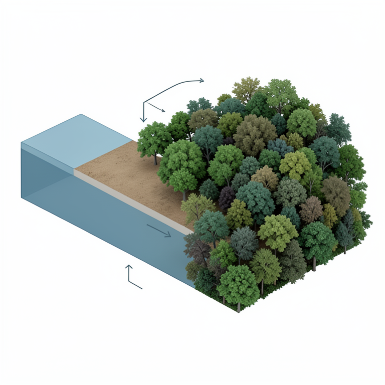
Site Suitability Logic
AI-generated conceptual illustration (Urban landscape of Kota city with native forest patches). It explains the idea and does not show study data.
View source evidence ↗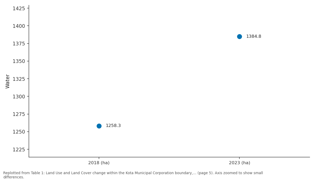
Water: 2018 (ha) vs 2023 (ha)
Replotted from Table 1 (page 5) of the original paper. Every bar is the paper's own table value.
View source evidence ↗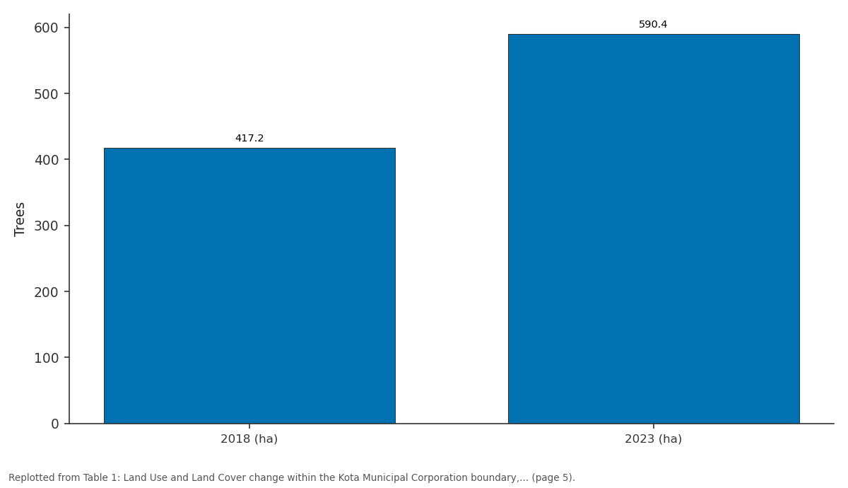
Trees: 2018 (ha) vs 2023 (ha)
Replotted from Table 1 (page 5) of the original paper. Every bar is the paper's own table value.
View source evidence ↗Figures & tables
From the original paper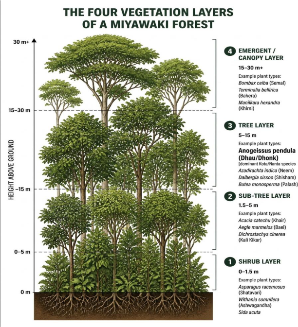 Figure 1
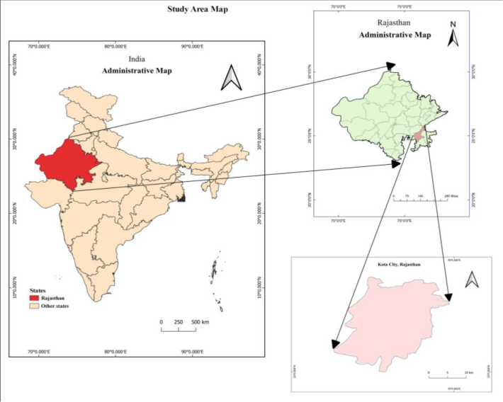 Figure 2
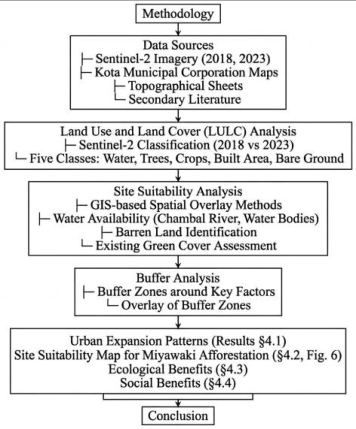 Figure 3
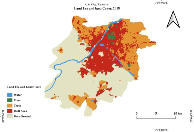 Figure 4
 Table 1
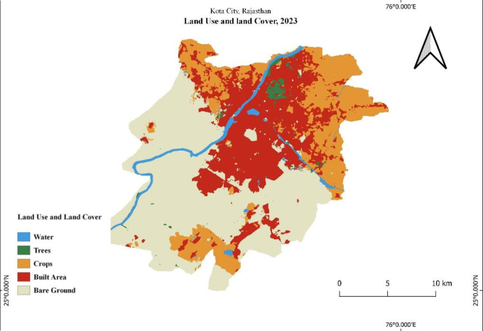 Figure 5
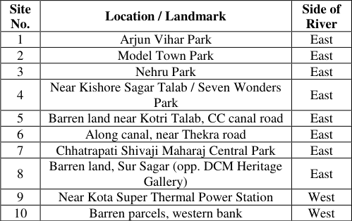 Table 2
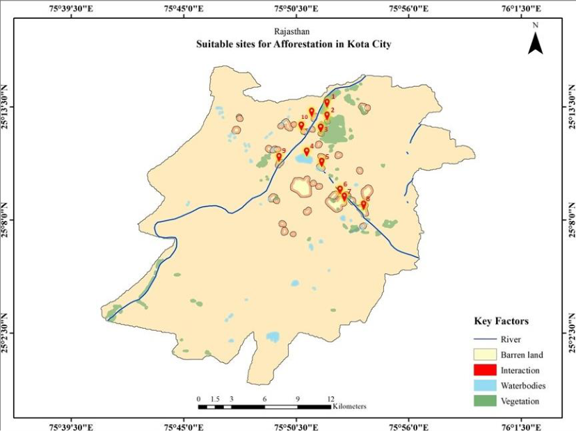 Figure 6
Introduction "I can't stop cutting down of trees. But I can start growing trees." -R. K. Nair
The Miyawaki Method is named after the Japanese botanist and plant ecologist Akira Miyawaki [1] , who introduced an innovative approach to urban reforestation that establishes dense, fast-growing forests in compact areas [2] . It works by preparing the topsoil and planting native species together, and the resulting forests absorb more carbon dioxide, cut noise more effectively, and grow denser green covers than conventional plantations do [3] . The approach has already found ground in Indian cities, with substantial tree plantations developed at the Sabarmati Riverfront in Ahmedabad as one example [4] .
Site requirements for the Miyawaki method
The Miyawaki method is particularly well-suited for urban environments due to its ability to thrive in small spaces with minimal maintenance after establishment. Though this method does not require any specific conditions, certain factors can aid a faster, healthier, and uninterrupted growth of the forest pockets. Before establishing the forest, it is essential to verify that the site has all the biophysical requirements for the growth of trees. As a commonly cited practical guideline, the minimum space needed to plant a Miyawaki forest is around 92 m 2 for a dense forest in which about 250 saplings are planted; however, this can be as few as 12 m 2 for a less dense forest [5] . It can be done on either private or public land with easy access and proximity to the most affected urban area. The selected site must have access to water, which is especially important in dry areas like Kota city.
Establishment process
The Miyawaki afforestation technique begins with an initial survey to assess the site's soil properties and identify the Potential Natural Vegetation (PNV) suited to its biophysical and geographical conditions. The method prioritizes growing species that are native and indigenous to the respective area, with the aim of establishing a self-sustaining plant community that requires minimal long-term human intervention once established. Following the identification of suitable species, the next step is to acquire seeds.
The choice of species is based on their nativity as well as their growth forms and vertical positions within the developing plant community. The selected species are arranged in a way that results in a multi-layered vegetation structure comprising shrub, sub-tree, tree, and canopy layers, as illustrated in Fig. 1. The selected seeds are then carefully sown in grow bags, from which the resulting seedlings are later raised. These grow bags contain a potting mixture of soil, cocopeat, dry cow dung, and other organic matter to provide nutrients and a conducive medium for initial growth. To ensure initial care and protection, these seedlings are kept under partial shade for 2-3 months before being transplanted to the main site. Before planting the seeds onto the site of concern, an important stage includes preparing the site. This essentially involves loosening the soil and improving its structure and water holding capacity by incorporating organic biomass such as wood chips and agricultural residues. Thereafter, the saplings representing different forest layers are planted at a high density, typically around four saplings per square metre. Organic mulch helps retain soil moisture and reduce erosion, while sticks or other supports may be used to protect young plants. Regular irrigation and weeding are generally required during the initial 2-3 years of establishment, after which the developing vegetation community may require considerably less human intervention.
Source: Prepared by the author; shrub-layer species after a Hadoti-region herb survey, tree and sub-tree layer species after a Nanta forest tree survey.
Fig 1:
The four vegetation layers of a Miyawaki forest, with candidate native species for each layer.
These species selections are done through two regional surveys. One of them is documented survey of wild herbs across the Hadoti region, informing the shrub-layer species [6] , while the other one is from a phytosociological survey of the Nanta forest in Kota district, informing the tree, subtree, and canopy layer species [7] . Existing literature on the Miyawaki method in India is largely descriptive or promotional, and published sitesuitability assessments that combine land use and land cover change with a spatial identification of candidate afforestation sites remain scarce for Rajasthan's semi-arid cities; no such assessment appears to exist for Kota specifically. This study addresses that gap.
Objectives
The study is guided by two objectives To analyse land use and land cover change in Kota's urban area to identify suitable sites for Miyawaki afforestation using GIS and Remote Sensing To explore the ecological and social benefits that the Miyawaki method offers to urban habitats.
2: Study Area
The study area for this research comprises the main city of Kota, as shown in Fig. 2, which forms the core of urbanism in the Kota district of Rajasthan. Kota city is located about 240 km south of Rajasthan's capital city Jaipur, at approximately 25°10′ 57″N latitude and 75°50′ 20″E longitude, with an elevation of 267 metres above sea level. It lies along the banks of the Chambal River, forming part of the Hadoti region in southern Rajasthan. Geographically, Kota features a semi-arid climate with sparse vegetation and seasonal rainfall, typical of Rajasthan. Forest patches in the wider district, such as the Nanta Forest region, retain a notable diversity of native and ethnomedicinally important plant species [8] . A phytosociological survey of a protected stand within this forest recorded thirty native tree species, dominated by Anogeissus pendula alongside associates such as Acacia catechu, Acacia nilotica, Azadirachta indica, Butea monosperma, Dalbergia sissoo, Bombax ceiba, Tamarindus indica and Ficus religiosa [7] , broadly consistent with the wider Anogeissus pendula-dominated dry-deciduous vegetation reported across Rajasthan's semiarid tracts [9] . These species offer a starting point for identifying Potential Natural Vegetation for Miyawaki plantations within Kota city, though the final species selection would still need field verification.
Source: Prepared by the author. This makes the city centre susceptible to the ill effects of urbanisation, as well as an appropriate site to grow mini forests using the Miyawaki method. The quantitative land use and land cover analysis in Section 4.1, by contrast, covers the full Kota Municipal Corporation boundary, since the underlying land cover product was clipped to that administrative limit rather than to the city centre alone.
Materials and Methods
Source: Prepared by the author.
Fig 3:
Overall methodology adopted for the study, from data collection to conclusion.
Data sources
This study relied mainly on secondary data to analyse land use, identify suitable sites for Miyawaki afforestation, and assess the ecological and social benefits of the technique.
Land use and land cover data were obtained from the Esri/Impact Observatory Sentinel-2 10 m resolution global Land Use/Land Cover time series (tile 43R) for 2018 and 2023, along with Kota Municipal Corporation maps, topographical sheets, and published reports. Secondary literature, comprising research papers, journal articles, and biodiversity studies, provided additional insight into the ecological and social impacts of the Miyawaki method.
Land use and land cover analysis
Land use and land cover (LULC) analysis is a wellestablished method for monitoring the pattern and pace of urban expansion [10][11][12] . The Esri/Impact Observatory Sentinel-2 Land Cover product for 2018 and 2023 was clipped to the Kota Municipal Corporation boundary using the Clip Raster by Mask Layer tool in QGIS. The Esri/Impact Observatory Sentinel-2 Land Cover product is generated using a deep-learning classification model trained on over five billion human-labelled pixels, with a reported overall accuracy of 86% on its validation set [13] ; an independent comparison study found an overall accuracy of 75% for this product globally, with per-class accuracies of 92% for water, 83% for built area, 81% for trees, and 78% for crops [14] . A Unique Values Report was run on the clipped raster for both the years to obtain pixel count of every class. These counts were converted to hectares by multiplying by 0.01. Seven classes were present within the boundary. Fig. 4 and Fig. 5 present the resulting maps using five broad classes, namely Water, Trees, Crops, Built Area, and Bare Ground, for ease of visual interpretation, while the underlying analysis distinguished two further classes present in smaller proportions, Rangeland and Flooded Vegetation, reported separately in Table 1. The 2018 and 2023 rasters were also combined in the Raster Calculator, which made it possible to trace, pixel by pixel, which classes had converted into Built Area over the five-year period.
| LULC Class | 2018 (ha) | 2023 (ha) | Change (ha) | Change (%) |
|---|---|---|---|---|
| Water | 1,258.3 | 1,384.8 | +126.4 | +10.0 |
| Trees | 417.2 | 590.4 | +173.2 | +41.5 |
| Flooded Vegetation | 1.3 | 7.6 | +6.4 | +496.9 |
| Crops | 12,287.7 | 10,630.2 | −1,657.5 | −13.5 |
| Built Area | 11,480.9 | 13,420.1 | +1,939.3 | +16.9 |
| Bare Ground | 51.1 | 36.6 | −14.5 | −28.4 |
| Rangeland | 23,518.9 | 22,945.6 | −573.3 | −2.4 |
| Total | 49,015.4 | 49,015.3 | N/A | N/A |
Table text extracted from the original PDF; superscript letters are shown inline. The original table image is below.
View original table image
Site suitability:
Site suitability analysis for Miyawaki afforestation was carried out in QGIS using spatial overlay methods, considering the confluence of key factors that favour forest growth. Water availability was one such factor, since it is essential for the survival of any newly planted forest. Mapping the Chambal River and other water bodies helped ensure that shortlisted sites lay close to a water source, reducing the logistical burden of irrigation once the forest is planted. The Buffer tool in QGIS was used to create zones of influence around water bodies, barren land, and existing green cover, marking the areas each factor could reasonably be considered to affect. Barren land was treated as a key factor too, since it offers a blank canvas for restoration without the need to displace existing vegetation or infrastructure. Existing green cover was also factored in, mainly to strengthen connectivity between fragmented patches and support biodiversity and ecological continuity across the city. These three buffered layers were then visually overlaid, and the areas where all three showed interaction, marked as such in Fig. 6, were identified through visual interpretation informed by local knowledge of land accessibility and existing land use. These became the suitable sites for Miyawaki plantations. The ecological and social impact analysis was drawn mainly from secondary literature and was used to evaluate the method's potential to restore biodiversity and improve social liveability. Within the Kota Municipal Corporation boundary, Built Area increased from 11,480.9 ha in 2018 to 13,420.1 ha in 2023, depicting a net gain of 1,939.3 ha (16.9%), raising its share of the municipal area from about 23.4% to 27.4% (refer to Table 1). Cropland fell by 1,657.5 ha (13.5%) over the same period, while tree cover rose from 417.2 ha to 590.4 ha, showing a gain of 41.5%; water and rangeland changed comparatively little, at +10.0% and -2.4% respectively. A pixel-level comparison of the two years shows that new built-up land came mostly at the expense of cropland (1,410.6 ha converted) and rangeland (825.1 ha converted), which suggests that expansion is consuming farmland and open scrub rather than existing tree cover. It was observed that a small share of build-up pixels (381.1 ha) and trees pixel changes can be due to the classifier uncertainty at class boundaries rather than actual deurbanization. Accounting for this, the gross extent of new construction totalled 2,320.4 ha. This pattern is consistent with an independent Google Earth Engine-based study of Kota, which reported a 122.38% increase in built-up area between 2000 and 2023, correlated with a 294.16% rise in solid waste generation and a 24.6% increase in urban surface temperature [15] , reinforcing the case for restorative interventions such as the Miyawaki method, which can help offset the ecological costs of this expansion. Areas are displayed to one decimal place, but changes and percentages were calculated from unrounded values; minor discrepancies on manual recalculation from the rounded figures shown here are a rounding artefact rather than a computational error.
Results and discussion
Besides this change in the spatial dynamics, a stark difference in the urban occupancy was noted between north Kota and South Kota (previously two separate parts of the Municipal Corporation of Kota which have now been unified into one whole). Such a pattern can be attributed to historical, developmental, infrastructural, economic and other urban factors. One possible reason behind such a distribution is the northern part being the original core of the city, still retaining within itself the walled city and the fort where the city's genesis began. The rest of the city was initially mostly forests and wilderness, but with rapidly increasing population due to urbanization and development of diverse economies, the city expanded gradually towards more areas in the northern part and then further to the central parts. The urban expansion is now directed towards the south at a considerable speed. This expansion is still going on and is significantly palpable, with residents shifting towards the less densely populated and more forested southern periphery for a better quality of life, moving away from the Central Business District in the north. However, growth often comes at the expense of natural vegetation and open spaces, potentially threatening to disrupt the city's ecological balance if not conducted wisely. These findings point to a need for urban forestry initiatives, such as the Miyawaki method, to restore greenery within city limits and counterbalance the environmental impacts of increased urbanisation.
Site suitability for Miyawaki afforestation:
After considering the key factors that promote quick and healthy growth of Miyawaki urban forests, a suitability map was prepared (refer to Fig. 6), showing the zones of influence of the key environmental factors and the areas where they intersect. These areas of intersection were found to be the most suitable sites for the Miyawaki method. Greater focus was placed on the northern part of the city because of its more congested, unhealthy, and rapidly increasing urban nature. The identified sites were roughly divided between the west and east sides of the Chambal River.
Source: Prepared by the author. [16] . For a swiftly expanding and intensively urbanizing city like Kota, where rising temperatures due to increasing vehicular and infrastructural load pose challenges, such microclimatic improvements are essential for creating sustainable and comfortable urban habitats. Traditionally, forests grown by the Forest Department had the single objective of producing timber and revenue through plantation; monoculture was the chief method of afforestation, which does not provide the biodiversity that natural forests bring [17] . This lack of biodiversity adversely affects fauna and the overall ecosystem. The Miyawaki method attempts to resolve this issue by mimicking natural forests as closely as possible, introducing a rich biodiversity of indigenous species within a small area.
The growing influx of people, particularly students, into Kota each year increases problems such as noise, pollution, greater carbon emissions, and loss of biodiversity. Vegetation established through the Miyawaki method can help combat these issues by growing dense forests in a short span of time, acting as efficient carbon sinks and helping minimise local warming. As reported in Singh and Saini [18] (citing a 2016 BBC News account of Nature Conservancy research), trees near urban areas have been associated with an average reduction in particulate matter of between 7% to 24%, with an associated cooling effect of around 2°C. In this way, the Miyawaki method offers both ecological benefits and practical solutions to Kota's pressing urban challenges. However, the empirical evidence base for several commonly claimed Miyawaki benefits, including accelerated growth, self-sustainability, and enhanced carbon sequestration, remains thin; a recent systematic review found that most such claims are weakly or not supported by controlled, replicated studies [19] , which points to a need for outcome monitoring if the method is applied in Kota.
Conclusion
The Miyawaki method is a technique for growing small, dense forests in urban areas. In Kota, the need for plantation has become urgent because of a sharp rise in built-up area over the last five years. The northern part of Kota has become overcrowded, pushing residential development southwards. The most suitable sites for applying the Miyawaki method identified by this study are located primarily in the northern part of the city, including areas near Seven Wonders Park, the army cantonment area, Kishore Sagar Talab, the thermal power station, and along the Chambal River. Implementing this method at these sites is expected to bring meaningful ecological and social benefits to Kota. This study rests on secondary spatial data and published literature rather than field survey, so the site boundaries and areas given here are best treated as a preliminary, deskbased assessment. Before any of these sites are actually planted, the proposed locations should be ground-truthed, the soil tested, the candidate native (PNV) species outlined in Section 2 verified and refined for Kota's semi-arid conditions, and the land use and land cover classification checked for accuracy. Land ownership and zoning have also not been assessed here, converting existing parkland to a Miyawaki forest would need municipal approval, and the site near the Kota Super Thermal Power Station would need soil and pollution screening before planting, given its proximity to an industrial facility.
Figures and tables from the paper
| Site No. | Location / Landmark | Side of River |
|---|---|---|
| 1 | Arjun Vihar Park | East |
| 2 | Model Town Park | East |
| 3 | Nehru Park | East |
| 4 | Near Kishore Sagar Talab / Seven Wonders Park | East |
| 5 | Barren land near Kotri Talab, CC canal road | East |
| 6 | Along canal, near Thekra road | East |
| 7 | Chhatrapati Shivaji Maharaj Central Park | East |
| 8 | Barren land, Sur Sagar (opp. DCM Heritage Gallery) | East |
| 9 | Near Kota Super Thermal Power Station | West |
| 10 | Barren parcels, western bank | West |
Table text extracted from the original PDF; superscript letters are shown inline. The original table image is below.
View original table image
References
21 in the original paper- Miyawaki A. Creative ecology: restoration of native forests by native trees. Plant Biotechnology. 1999;16(1):15-25.
- Poddar S. Miyawaki technique of afforestation. Zenodo (CERN European Organization for Nuclear Research). 2021. doi:10.5281/zenodo.5893933.
- Kocheta S, Halhalli M. The Miyawaki technique: afforestation solution for mitigating Urban Heat Island effects by increasing native green cover. TEST Engineering & Management. 2020;83. Available from: https://www.testmagzine.biz/index.php/testmagzine/arti cle/view/4446
- Sandip R, Sharma P, Modi N. Development of tree plantation through Miyawaki method at Sabarmati Riverfront Development Corporation Limited -a research. International Association of Biologicals and Computational Digest. 2022;1(1):26-38.
- Greener.Land. Miyawaki Forest [Internet]. [cited 2024 Oct 16]. Available from: https://www.greener.land/index.php/product/miyawakiforest/
- Choudhary A, Sharma P, Kharoliwal S, Khandelwal M. Medicinal wild herbs diversity and its uses by tribals of Hadoti region, India. Journal of Medicinal Plants Studies. 2023;11(1):191-194.
- Malav A, Jaiswal P. Species composition and diversity of tree species in Nanta forest region in Kota district, Rajasthan, India. International Journal of Environment and Climate Change. 2023;13(4):220-227.
- Malav A, Dadhich P, Jaiswal P. Ethnomedicinal plant diversity and their usage among rural communities in Nanta Forest Region, Kota District, Rajasthan. International Journal of Pharmaceutical Sciences and Research. 2023;14(7):3566-3574.
- Sultana A, Hussain MS, Rathore DK. Diversity of tree vegetation of Rajasthan, India. Tropical Ecology. 2014;55(3):403-410.
- Feranec J, Soukup T. Land cover and land use. In: Loczy D, Stankoviansky M, Kotarba A, editors. Recent Landform Evolution. Dordrecht: Springer; 2012. p.3944.
- Sleeter B, Loveland TR, Domke GM, Herold N, Wickham J, Wood NJ. Chapter 5: Land cover and land use change. In: Impacts, Risks, and Adaptation in the United States: The Fourth National Climate Assessment, Volume II. Washington DC: U.S. Global Change Research Program; 2018. p.202-231.
- Sonowal G, Thakuriah G. Land use and land cover detection using geo-spatial tools for sustainable land use planning. Ecology, Environment and Conservation. 2022;28(S1):28.
- Karra K, Kontgis C, Statman-Weil Z, Mazzariello JC, Mathis M, Brumby SP. Global land use/land cover with Sentinel-2 and deep learning. IGARSS 2021-2021 IEEE International Geoscience and Remote Sensing Symposium. IEEE; 2021. p.4704-4707.
- Venter ZS, Barton DN, Chakraborty T, Simensen T, Singh G. Global 10 m land use land cover datasets: a comparison of Dynamic World, World Cover and Esri land cover. Remote Sensing. 2022;14(16):4101.
- Kumar P, Choudhary MP, Mathur AK. Exploring spatial dynamics of urbanization and solid waste generation in Kota city using the Google Earth Engine. Environmental Monitoring and Assessment. 2025;197:212.
- Nowak DJ, Dwyer JF. Understanding the benefits and costs of urban forest ecosystems. In: Kuser JE, editor. Urban and Community Forestry in the Northeast. 2nd ed. Dordrecht: Springer; 2007. p.25-46.
- Parikh A, Nazrana A. Analysis of the Miyawaki afforestation technique. International Journal of Development Research. 2023;13(10):63913-63915.
- Singh C, Saini G. Sustainable solution for urban environment: Miyawaki Forest. International Journal of Technical Innovation in Modern Engineering & Science. 2019;5(Special Issue 4):1-5.
- Morales NS, Fernandez IC, Duran L, Craven D. Tiny forests, huge claims: the evidence gap behind the Miyawaki method for forest restoration. Journal of Applied Ecology. 2026;63(1).
- Schroeder HW. Environment, behavior, and design research on urban forests. In: Zube EH, Moore GT, editors. Advances in Environment, Behavior, and Design. Vol 2. Boston, MA: Springer/Plenum Press; 1989. p.87-117.
- Ulrich RS. View through a window may influence recovery from surgery. Science. 1984;224(4647):420421.
Social benefits
Beyond the quantifiable benefits that urban forestation brings to the ecology and environment, there are several ways in which it contributes to social well-being. Urban forest environments enhance the aesthetic quality of residential streets and community parks, and contribute to the overall visual character of urban spaces 2 . Having forest covers and greenery has a substantially positive impact on the physical, emotional, spiritual, and psychological wellbeing of residents. This becomes especially relevant in the social context of India, where trees have long been an integral part of community life, offering both spiritual and social value. In such a social context trees don't just hold ecological or aesthetic value, they become effective spaces of worship, informal social interaction, gathering, and community activities.
The presence of trees has a profound impact on humans. In urban setting, having common green spaces can be linked to improved emotional state and a deepened connection with nature. Research has shown that hospital patients with views of greenery recover faster and with fewer complications. This demonstrates the healing potential of natural environments [21] . By involving the residents in regular community-based activities where they are asked to plant new saplings, and take the responsibility for the trees in their vicinity, a sense of ownership and environmental connection can be fostered among the people, while creating opportunities for collective action and community participation. Such initiatives can therefore contribute not only to environmental improvement but also to social cohesion and a shared sense of responsibility towards the local environment.
Having abundant public spaces with natural environments innately encourages nature-based physical activity, and provide opportunities for recreation and social interaction, thereby contributing to overall well-being. This is particularly important for children. Overtime, a rapid decline in public parks and playing grounds has been observed, mostly driven by the need to clear the area for infrastructure related developmental projects. This decline of natural play spaces can deeply compromise with health, personality development, and cognitive growth among children. Especially in a city like Kota, where the intense pressure of competitive examinations can contribute to considerable academic and psychological stress among students, access to nature and physical activity can significantly reduce stress levels among young learners.