
Research article · 2026 · Full text
International Journal of Geography Geology and EnvironmentSpatio-temporal analysis of "Mahendrasagar" pond in tikamgarh district (M.P) using geospatial techniques
Volume 8(8) · Pages 108–113 · DOI: 10.22271/27067483.2026.v8.i8a.855 ↗
Research areasGroundwater and Watershed AnalysisRemote Sensing and Land UseWetland Management and Conservation
Abstract
Author-writtenMahendraSagar Pond, situated on the outskirts of Tikamgarh District in Madhya Pradesh, is a critical local water source that supports domestic water needs, Recharge groundwater levels, moderates the micro‑climate, and Sustains diverse ecosystems and surrounding land use activities. In recent years, however, rapid population growth, urban expansion, and intensifying human interventions have visibly altered the pond’s watershed, seasonal water regime, and adjacent land use, putting pressure on its ecological and hydrological functions.Satellite data from Landsat 8 was used for the year 2014, while data from Sentinel-2 was used for the years 2018, 2022, and 2026(month of January).This data was processed in the Google Earth Engine for image processing. The Normalized Difference Water Index (NDWI) was used to depict the pond's extent, and area statistics were generated to assess changes in the pond's area over time.Land use and land cover (LULC) within a buffer area around the pond were examined to evaluate how surrounding human activities particularly urban growth and agricultural uses have influenced the characteristics and functioning of the waterbody. The results clearly show that the MahendraSagar Pond watershed undergoes pronounced seasonal and inter‑annual fluctuations in its hydrological characteristics. Evidence of progressive encroachment and land use change in the area surrounding the lake has also been identified. This study further highlights the uses of geospatial technologies, particularly GIS and remote sensing, for the continuous monitoring of water bodies. In light of these findings, timely conservation and sustainable management interventions are crucial to safeguarding the environmental and hydrological significance of MahendraSagar Pond in the Tikamgarh district.
Summary
Source-checkedPlain-language reading of the full paper, prepared with AI and checked against the text. Each point links to the authors' own words.
Why it matters
- In semi-arid regions of India like Bundelkhand, ponds are essential for ecological stability and providing water for irrigation, domestic use, and groundwater recharge. View evidence ↗
- The health and spatial distribution of small ponds are increasingly threatened by unplanned human interventions, agricultural expansion, and rapid urbanization. View evidence ↗
- MahendraSagar Pond in Tikamgarh District is a critical resource that sustains local ecosystems, moderates the micro-climate, and supports domestic water needs. View evidence ↗
The question
- The study aims to map the spatial extent of MahendraSagar Pond, quantify its water spread changes over time, and analyze how urban and agricultural expansion affect the surrounding land use. View evidence ↗
What they did
- The researchers used Landsat 8 satellite data from 2014 and Sentinel-2 data from January of 2018, 2022, and 2026. View evidence ↗
- A Random Forest algorithm was applied to Sentinel-2 imagery for supervised classification of land cover types in 2026, including urban areas, water, vegetation, and agricultural land. View evidence ↗
- A 2-km buffer zone around the pond was established to assess land use and land cover dynamics using 2026 data. View evidence ↗
What they found
- The MahendraSagar Pond watershed exhibits significant hydrological fluctuations both seasonally and between different years. View evidence ↗
- The study identified progressive land use changes and encroachment in the areas surrounding the pond. View evidence ↗
- The scattered distribution of built-up areas, including roads and houses, indicates ongoing urban expansion around the pond. View evidence ↗
- Field observations indicate that water levels are driven by monsoon rainfall and decline in the dry season, while silt accumulation has lowered the pond's storage capacity. View evidence ↗
- Household garbage and plastic waste were observed along the banks, negatively impacting the site's visual appeal and water quality. View evidence ↗
What it means
- The authors recommend implementing periodic desiltation, waste disposal regulations, community awareness, tree planting, and improved drainage to conserve the pond. View evidence ↗
- The study concludes that remote sensing and GIS are effective and practical tools for the continuous monitoring of traditional ponds. View evidence ↗
Visual summary
1 visualsIllustrations explain the paper; they do not show study data.
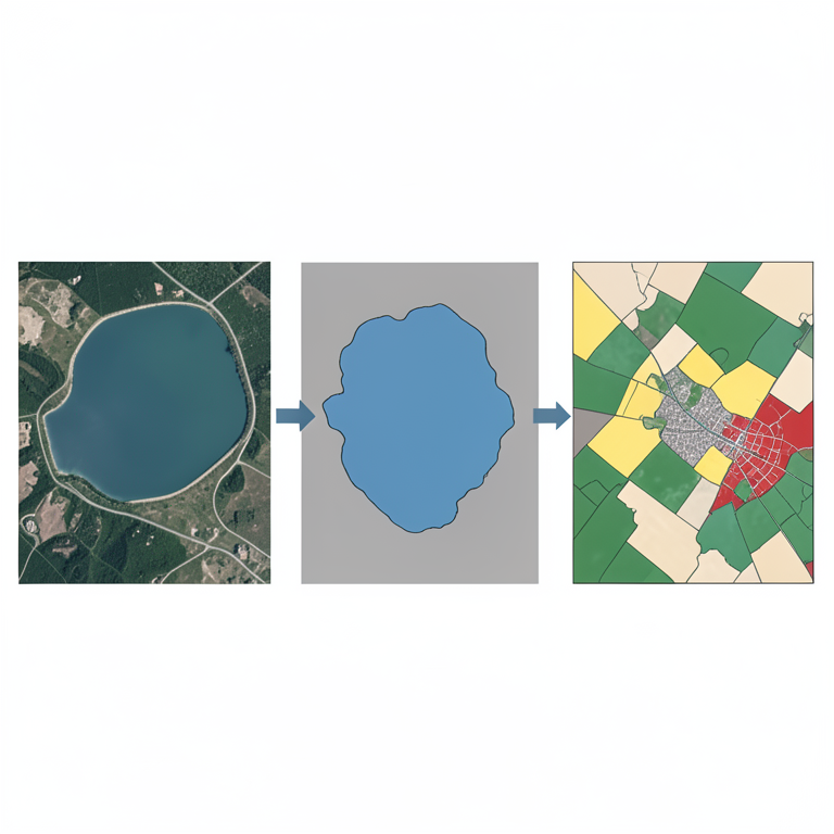
Geospatial Analysis Workflow
AI-generated conceptual illustration (Mahendrasagar pond and its surrounding landscape in Tikamgarh district). It explains the idea and does not show study data.
View source evidence ↗Figures & tables
From the original paper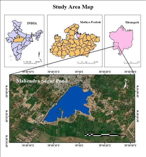 Figure 1
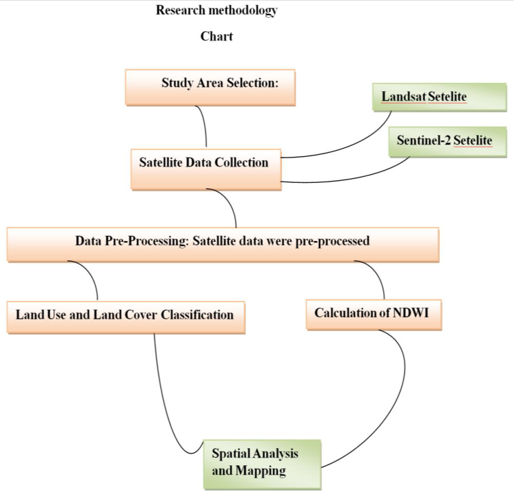 Figure 2
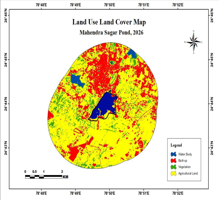 Figure 3
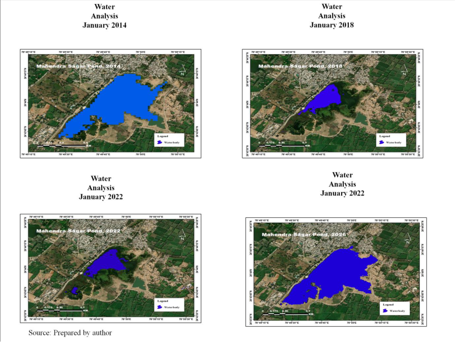 Figure 4
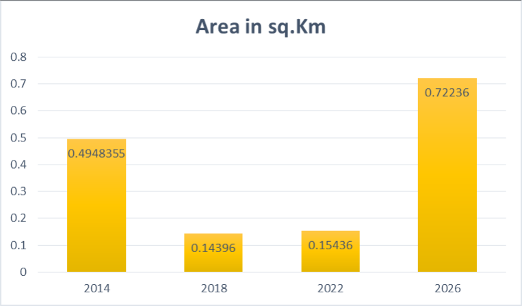 Figure 5
Introduction
Ponds are a fundamental component of rural and urban Area in India, particularly in semi-arid climate regions such as Bundelkhand, where they serve as vital sources of domestic water supply, irrigation, groundwater recharge, and ecological stability. Traditional water bodies, including the MahendraSagar Pond in Tikamgarh district, Madhya Pradesh, have historically supported local livelihoods and helped maintain the hydrological balance of the region. However, rapid urbanization, expansion of agricultural activities, and unplanned human interventions have increasingly threatened the health, continuity, and spatial distribution of many small ponds. Under these circumstances, geospatial technologies particularly remote sensing and GIS have emerged as powerful tools for monitoring and managing water resources, enabling systematic assessment of their condition and spatio-temporal changes. Geographic Information Systems (GIS) and remote sensing allow for accurate and cost-effective assessment of changes in surface water bodies over time and space (Thirumurthy et al.2022) [1] . Indices such as the Normalized Difference Water Index (NDWI) and Normalized Difference Vegetation Index (NDVI) derived from satellite imagery are widely regarded as reliable tools for mapping waterlogged areas and evaluating the environmental conditions of their surrounding landscapes, especially when they are used together to distinguish open water from vegetation and soil in a consistent, quantitative way. (NASA Scientific Visualization Studio. 2021) [2] . These indices are particularly useful in semi-arid regions, where frequent monitoring is required to capture seasonal variability in surface water and vegetation. In recent years, freely available, high-resolution satellite Missions such as Sentinel-2, combined with cloud-based processing platforms like Google Earth Engine, have greatly improved the capability to track small ponds and other inland water bodies continuously over long time periods. These technologies allow researchers to build multi-year image time series, apply indices such as NDWI and NDVI at scale, and generate detailed maps of spatio-temporal changes in water spread area and surrounding land cover with relatively low cost and effort. Within this broader context, Tikamgarh district characterized by erratic rainfall and recurrent water scarcity faces significant pressure on its traditional water bodies, making the conservation and sustainable management of ponds especially important for local water security and ecosystem health. The MahendraSagar Pond plays a key role as a source of water for nearby settlements and agricultural fields, and contributes to the resilience of the regional ecosystem, yet dedicated geospatial analyses of its long-term dynamics have so far been scarce. Accordingly, the present study concentrates on MahendraSagar Pond with four main objectives: to delineate the spatial extent of the pond, to quantify changes in its water spread over time, to examine land use and land cover patterns in a defined buffer around the pond, and to evaluate how these changes reflect broader anthropogenic pressures such as urban expansion and agricultural intensification. The insights generated are intended to support conservation efforts, inform evidence-based planning, and guide the sustainable management of ponds and similar small water bodies across the Bundelkhand region, where such traditional systems remain critical for water provisioning and ecological balance.
Study Area
MahendraSagar Pond is a major urban water body situated near Talkoti in the outside of city Tikamgarh, Madhya Pradesh, and is highly influenced by surrounding human activities and infrastructure. (Patrika.2024, December 11) [3] . Its location within the dense urban fabric, close to transport routes and residential areas, makes it easily accessible and ensures that it is actively used by local people throughout the day. The pond lies roughly 2 km from the main bus stand of Tikamgarh, and the primary state highway is about 2-3 km away, as determined from GPS measurements and map analysis carried out for this study., allowing convenient access by walking, bicycle, or auto-rickshaw. Because the area around the pond includes residential colonies, small shops, and public spaces, human interaction with the pond environment is frequent and intensive, making it an ideal site for studying the relationship between urban development and water bodies.
Hydrologically, MahendraSagar Pond is predominantly rain-fed, with water levels rising during the monsoon and creating a more attractive and comfortable landscape. In the evenings, residents visit the pond for walking, leisure, and relaxation in a semi-natural setting, and recent beautification and boating initiatives have further increased its recreational and tourism value. From an environmental perspective, the pond helps moderate the local micro-climate by influencing temperature and humidity, and it supports biodiversity in the form of fish, aquatic plants, and seasonal birds. However, its urban setting also exposes it to pollution, plastic waste, encroachment, and siltation, which threaten its ecological health and long-term sustainability. Overall, MahendraSagar Pond is a crucial urban water resource that delivers environmental, social, and economic benefits, while also serving as an important study area for understanding urban water management, conservation practices, and the impacts of human activity on natural resources in a growing town.
Research Problem
MahendraSagar Pond in Tikamgarh district, Madhya Pradesh, is a significant traditional water body that contributes to local water supply, agricultural use, and ecological stability within the Bundelkhand region. In recent years, however, the pond has come under growing stress from urban expansion, intensified agriculture, sediment build-up, and increasingly irregular rainfall. These pressures are likely to have changed both the pond's water-spread extent and the surrounding land-use patterns, yet up-to-date, scientifically robust information on these changes remains limited. Most existing records for the pond are derived from field observations or administrative sources, which tend to be partial, outdated, and unsuitable for continuous monitoring. In the absence of accurate spatio-temporal assessments, planners and local authorities struggle to detect encroachment, seasonal contraction of the water area, or long-term ecological degradation of the pond system. This knowledge gap is especially serious in the water-scarce Bundelkhand region, where traditional ponds are central to local water security. Therefore, a systematic geospatial investigation using GIS and remote sensing is needed to track temporal variations in MahendraSagar Pond and to examine land use/land cover dynamics in its vicinity, providing a scientific basis for its conservation and sustainable management. Objectives 1. To delineate the boundary of MahendraSagar Pond using multi-temporal satellite imagery.
2. To analyse the spatio-temporal variations in the pond's water-spread area.
Study Area Selection
The study centres on MahendraSagar Pond, a key water resource in Tikamgarh district. This area was selected to examine how the pond's water extent and the surrounding land use have changed over time, both within the water body and in its immediate environs.
Satellite Data Collection:
Landsat 2014 images were used to assess the pond past water levels Sentinel-2 (2018, 2022, 2026) images were used to assess recent changes in water and land use.
Data Pre-Processing: Satellite data were pre-processed, which included the following procedures Cloud masking was applied to remove clouds and cloud shadows from the satellite images, ensuring that only clear-sky pixels were used for analysis. Geometric correction was performed to accurately align all images to the same spatial reference, allowing consistent comparison across dates. Atmospheric (radiometric) correction was then carried out to minimise atmospheric effects and convert the data to surface reflectance values suitable for quantitative analysis.
Calculation of NDWI
The Normalized Difference Water Index (NDWI) was computed to identify and analyse surface water resources in the study area. NDWI is defined as the normalized difference between the green and near-infrared (NIR) bands: \(\text{NDWI} = (\text{Green} -\text{NIR}) / (\text{Green} + \text{NIR})\). For Sentinel-2 imagery, the Green band (Band 3) and the NIR band (Band 8) were used, whereas for Landsat 8 imagery (2014), the Green band (Band 3) and the NIR band (Band 5) were employed. NDWI was calculated in Google Earth Engine (GEE) for the years 2014, 2018, 2022, and 2026, and the resulting index values and derived water-spread areas were compiled in tabular form to visualize temporal changes in the pond's water resources.
Land Use and Land Cover (LULC) Classification: land use classification for the year 2026 was carried out using a supervised classification approach applied to Sentinel-2 imagery. A Random Forest algorithm was used to distinguish major land cover types, including water bodies, agricultural land, urban/built-up areas, and vegetation cover, which were then grouped into separate classes for analysis.
To evaluate changes in the surroundings of MahendraSagar Pond, a 2-km buffer zone was delineated around the pond, and land use/land cover dynamics within this buffer were assessed based on the classified 2026 data.
Spatial Analysis and Mapping
NDWI and LULC outputs were visualised and analysed through GIS-based mapping. NDWI results were displayed as raster maps in ArcGIS Pro, highlighting spatial variations in surface water across the study area and enabling comparison between different years. Land use/land cover (LULC) classifications for 2026 were also mapped, showing the distribution of major classes and the pattern of land use change around MahendraSagar Pond. In addition, Google Earth was used for regional visualisation and cross-checking of features, supporting interpretation of the mapped results and providing a clearer picture of the pond's surroundings.
Results and analysis
Source: Prepared by author it is subject to several environmental and management challenges. Field observations show that the pond's water level is largely controlled by monsoon rainfall, with a marked decline during the dry season. Silt accumulation has reduced its effective storage capacity, and in some stretches of the bank plastic waste and household garbage were observed, harming both water quality and the visual appeal of the site. Everyday human activities such as open washing, careless waste disposal, and unrestricted movement along the embankment are further contributing to gradual ecological degradation. At the same time, the pond continues to sustain aquatic life, including fish and seasonal birds, and plays a significant role in regulating the local microclimate of Tikamgarh. Recent beautification efforts and the introduction of boating facilities have enhanced its recreational and tourism value, yet the need for systematic monitoring and stronger environmental controls remains. Overall, the evaluation suggests that, while MahendraSagar Pond is still a key urban water resource, prompt conservation action is essential. Recommended measures include periodic desiltation, strict regulation of waste disposal, provision of dustbins, community awareness programmes, tree planting along the banks, and improved drainage management to prevent polluted inflows. If such strategies are effectively implemented, the pond's ecological condition can be substantially improved and maintained over the long term, thereby fulfilling the study's objective of assessing its status and proposing appropriate conservation and management interventions.
Conclusion
MahendraSagar pond is an important local water resource in Tikamgarh district, but the study indicates growing pressure on its sustainability. Although seasonal fluctuations are natural, the observed long-term variations and surrounding land use changes highlight the need for careful management. The research clearly demonstrates that GIS and Remote Sensing provide a powerful and practical method for continuous monitoring of traditional ponds. The long-term conservation of MahendraSagar pond, steps such as controlling encroachment, regular desiltation, proper catchment management, and community awareness are essential. Periodic geospatial monitoring should also be adopted by local authorities to track future changes. Implementing these measures will help protect the hydrological and ecological importance of the pond and support sustainable water resource management in the Bundelkhand region.
Figures and tables from the paper
References
5 in the original paper- Thirumurthy S, Jayanthi M, Samynathan M, et al. Assessment of spatial-temporal changes in water bodies and its influencing factors using remote sensing and GIS -a model study in the southeast coast of India. Environ Monit Assess. 2022;194:548. DOI:10.1007/s10661-022-10228-z
- NASA Scientific Visualization Studio. A global view of Normalized Difference Vegetation Index (NDVI). NASA Goddard Space Flight Center; 2021. Available from: https://svs.gsfc.nasa.gov/4915/
- Patrika. Mahendra Sagar "Petition filed to preserve Mahendra Sagar Lake accepted; administration forms a 9-member team.". Tikamgarh News. 2024 Dec 11. Available from: https://www.patrika.com/tikamgarhnews/the-petition-filed-to-preserve-mahendra-sagarlake-was-accepted-the-administration-formed-a-9member-team-19226240
- Google. Google Earth Engine Cloud-based geospatial analysis platform; 2026. Available from: https://earthengine.google.com
- United States Geological Survey. Landsat 8 OLI/TIRS Level-1 imagery. USGS EarthExplorer; 2014.