
Research article · 2026 · Full text
International Journal of Geography Geology and EnvironmentUrban Expansion towards the Tangri River: A GIS Based Assessment of the Changing River-Urban Interface in Ambala Cantonment, India
Volume 8(8) · Pages 83–88 · DOI: 10.22271/27067483.2026.v8.i8a.853 ↗
Research areasFlood Risk Assessment and ManagementRemote Sensing and Land UseLand Use and Ecosystem Services
Abstract
Author-writtenRapid urban expansion along river corridors is increasingly transforming the spatial relationship between settlements and natural drainage systems, with important implications for urban flood exposure. The present study examines the long-term transformation of the river-urban interface along the Tangri River in Ambala Cantonment, India, through a comparative analysis of historical topographic mapping and contemporary satellite imagery. A Survey of India topographic sheet representing the 1974 landscape and LISS-IV satellite imagery of 2025 were integrated within a GIS environment to reconstruct and compare the spatial configuration of built-up development over the intervening period. The historical built-up extent was interpreted and digitized from the topographic sheet, while contemporary built-up development was identified from the 2025 satellite imagery through visual interpretation and GIS-based digitization. The two temporal built-up layers were subsequently overlaid to examine the spatial pattern and direction of urban expansion, with particular emphasis on the progressive movement of development toward the Tangri River corridor. The results show that the river-urban interface has undergone a significant change, from the relatively small and fragmented built up areas of 1974 to the more extensive and continuous urban interface in 2025. The expansion of urban development toward the river indicates a changing spatial distribution of potentially exposed population, infrastructure and other urban assets. The growing amount of impervious urban surfaces could also affect surface runoff and drainage characteristics during periods of heavy rainfall. This study reveals that it is important to combine the historical land-use trajectories with current urban planning and flood-risk management.
Summary
Source-checkedPlain-language reading of the full paper, prepared with AI and checked against the text. Each point links to the authors' own words.
Why it matters
- Human settlements are often established on river floodplains because these areas provide easy access to water, transportation, and favorable living conditions. View evidence ↗
- When infrastructure and settlements occupy floodplains, they can disrupt natural drainage and reduce the space available for floodwaters, increasing disaster risk. View evidence ↗
- Northern India is particularly vulnerable to this issue because seasonal rivers from the Shivalik foothills react quickly to heavy monsoon rains. View evidence ↗
The question
- The study aims to investigate how built-up development along the Tangri River in Ambala Cantonment has changed over time using historical maps and modern satellite data. View evidence ↗
- The research specifically seeks to create a 1974 baseline, analyze the direction of urban growth up to 2025, and discuss the resulting impact on flood risk. View evidence ↗
What they did
- The researchers compared a 1974 Survey of India topographic sheet with 2025 LISS-IV satellite imagery. View evidence ↗
- The study used ArcGIS to overlay the digitized built-up layers from 1974 and 2025 to analyze the spatial patterns of expansion. View evidence ↗
What they found
- In 1974, urban settlements were relatively compact, with significant open spaces acting as a buffer between the built-up areas and the Tangri River. View evidence ↗
- By 2025, the urban area had expanded extensively outward, especially toward the east and southeast. View evidence ↗
- Built-up areas have encroached upon the middle and lower sections of the river corridor, reducing the historical distance between the river and the city. View evidence ↗
- The Tangri River's flow has frequently exceeded the danger mark of 15,400 cusecs, reaching a peak of approximately 38,000 cusecs in 2025. View evidence ↗
- Severe flooding in 2023 inundated several riverbank settlements, including Rampur, Sarsehri, Chandpura, Kardhan, Khojkipur, Babyal, and Defence Colony. View evidence ↗
- The 2025 floods caused significant waterlogging in colonies such as Sonia Colony, Vikas Puri, Prabhu Prem Puram, Lucky Nagar, Aman Nagar, and New Tagore Garden, highlighting the risk of urban growth near the river. View evidence ↗
- Rampur, Sarsehri, Chandpura, and Kardhan are identified as the most critical settlements due to their immediate proximity to the river. View evidence ↗
What it means
- The authors conclude that the expansion of urban development toward the Tangri River has likely increased the population's and infrastructure's exposure to flooding. View evidence ↗
- The authors recommend that flood-risk management in Ambala Cantonment must be integrated with long-term urban land-use planning. View evidence ↗
Visual summary
1 visualsIllustrations explain the paper; they do not show study data.
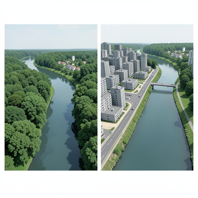
Conceptual Shift of the River-Urban Interface
AI-generated conceptual illustration (The Tangri River and surrounding urban landscape in Ambala Cantonment, India). It explains the idea and does not show study data.
View source evidence ↗Figures & tables
From the original paper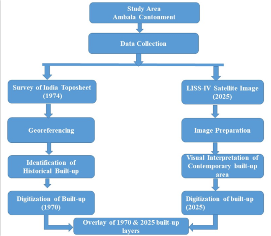 Figure 1
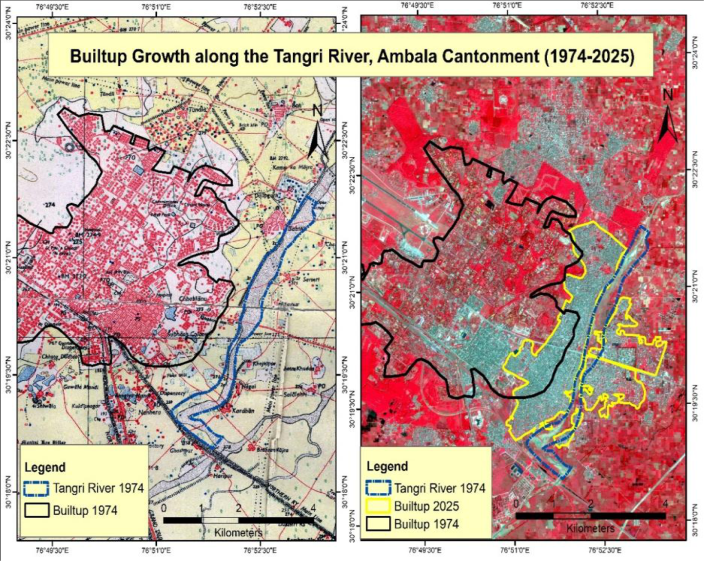 Figure 2
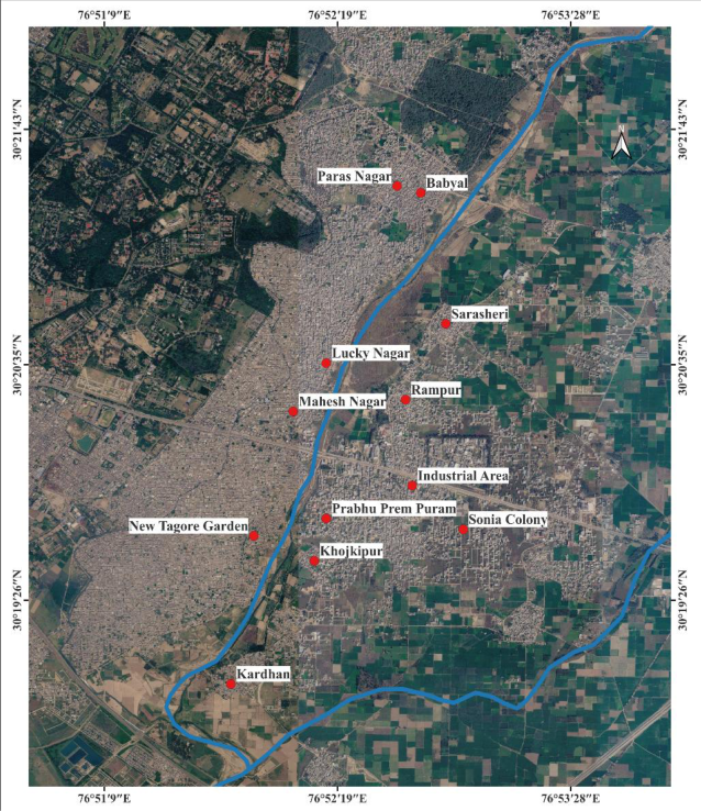 Figure 3
Introduction
Rivers have historically been an integral part in shaping the economic activities and settlement patterns of human societies (Grabowski et al., 2022) [5] . Urban settlements frequently develop along river floodplain due to the accessibility, availability of water resources, transportation opportunities and relatively favourable conditions for human occupation (Angelakis et al., 2023) [1] . The continue urban expansion into river floodplains represents one of the most important pathways through which disaster risk is increasingly being created instead of just experienced. Floodplains are dynamic geomorphic systems that are constantly evolving and provide a number of hydrological services such as temporary storage of flood water, sediment deposition, recharge and maintenance of ecological connectivity (Benito and Hudson, 2010) [2] . The occupation by settlements, roads, industrial sites and other infrastructure can reduce the available space for floodwater and disrupt natural drainage processes (Croke et al., 2016) [4] . Thus, even if the intensity of a hydrological event is within the historical range, flood effects could be enhanced due to a larger population or greater volume of assets being exposed to flooding. Rapid urbanization has intensified this problem in many parts of South Asia. The expansion of impervious surfaces, modification of natural drainage systems, alteration of river channel and encroachment of the floodplain, all of which have changed the flow and ability of the urban environment to absorb excess water. (Pervin et al., 2020) [9] . The use of remote sensing and GIS has then become significant in determining changes in river corridors, monitoring land-use transformation, and assessing spatial relationship between urbanization and flood prone areas (Wang, 2018; Hussain et al., 2022; Yahya, 2023) [12,6,13] . Historical maps and topographic sheets are particularly valuable because they provide a baseline against which contemporary satellite-derived landscapes can be compared. The problem is particularly relevant in northern India, where numerous seasonal rivers originating in the Shivalik foothills rapidly respond to intense monsoon rainfall. Ambala district in Haryana is exposed to flooding from several seasonal rivers, including the Ghaggar, Markanda and Tangri. The Tangri River in Ambala Cantonment provides an important context for examining these processes. Ambala has experienced considerable urban development and transformation, while the Tangri River passes through an increasingly urbanized landscape. Previous research has already identified Tangri-related flooding as a significant urban hazard and documented the role of inadequate drainage, increasing impervious surfaces, channel modification, encroachment, flood-risk modelling and urban flood vulnerability ( [3,10,11,8,7] . Comparatively less attention has been given to reconstructing the historical transformation of the Tangri floodplain itself and systematically demonstrating the extent to which contemporary urban development has occupied the floodplain identified in historical cartographic records. This distinction is important because the identification of floodplain encroachment requires a historical reference condition rather than merely mapping present-day land use. A comparison between historical topographic information and contemporary satellite imagery can therefore provide direct evidence of landscape transformation and the progressive creation of exposure. Recent events have reinforced the importance of this issue. During the 2023 floods, the Tangri caused substantial disruption to several settlements along its corridor, while local reporting in 2025 again highlighted the problems with encroachments and lack of flood-control measures. The present study investigates the temporal transformation of built-up development along the Tangri River, Ambala Cantonment through the integration of historical topographic mapping and contemporary satellite imagery. The study seeks to establish a historical spatial baseline of built-up development, examine the changing pattern and direction of urban expansion between 1974 and 2025, and also discuss the implications of the changing flood exposure and urban flood-risk management.
Study Area
Ambala Cantonment is a part of Ambala district in northern India, Haryana and the region of Ambala urban. It is an important strategic and administrative area and has been steadily urbanised due to residential, commercial, institutional, transportation and industrial activities. The Tangri River is a seasonal and monsoon-fed river associated with the Shivalik foothill and flowing through Ambala district before joining the Ghaggar River. Its discharge is influenced by monsoonal rainfall, and rapid increases in downstream flows. As the river approaches the relatively flat plains around Ambala, the decrease in terrain gradient and increasing urban development create conditions in which excess water can spread beyond the active channel. The Haryana Irrigation Department has set the danger mark of the river as 15,400 cusecs, which has been crossed on several occasions during the recent monsoon seasons, including a peak of around 38,000 cusecs in 2025. Several settlements and infrastructure development are situated close to the Tangri River. The first is a group of residential colonies such as Prabhu Prem Puram, New Ajit Nagar, Vikas Puri, and Sonia Colony, that have been built directly on or immediately adjacent to the riverbed which are legally meant for agriculture purposes but are being constructed with permanent structures over the years. The second is the HSIIDC industrial estate in Ambala Cantonment, having about130 manufacturing units producing scientific apparatus, furniture, and other goods, which lies on lowlying land adjoining the river and along NH-444A. The exposure in both zones was very high in 2023 and in 2025, indicating that there was no significant reduction of the underlying exposure between the two events.
Database and Methodology
The present study adopts a GIS-and remote-sensing-based comparative approach to examine the temporal transformation of built-up development along the Tangri River in Ambala Cantonment between 1974 and 2025. The analysis is based on two primary spatial datasets, namely the Survey of India topographic sheet of 1974 and LISS-IV satellite imagery of 2025. The historical topographic sheet was first georeferenced in a GIS environment using identifiable and relatively permanent reference features such as road intersections, drainage networks and other recognizable features to establish spatial correspondence with the contemporary dataset. The Tangri River was identified and digitized from the available historical and contemporary spatial information to provide a common reference for analysing the changing river-urban relationship. The built-up area represented on the 1974 topographic sheet was interpreted from the settlement and built-up features depicted on the map and subsequently digitized to generate the historical built-up layer. In contrast, the 2025 LISS-IV imagery demonstrates extensive outward urban expansion, particularly towards the eastern and south-eastern parts of the study area. The contemporary built-up boundary extends well beyond the historical extent, incorporating areas that were previously open or sparsely developed. This indicates that urban growth over the past five decades has not only increased settlement density but has progressively shifted the built-up footprint closer to the Tangri River.
Urban Expansion and the Changing River-Urban Interface
The spatial pattern of urban growth between 1974 and 2025 is distinctly non-uniform. Rather than occurring as isolated developments, the expansion has largely taken place through outward growth from existing settlements accompanied by infilling of previously undeveloped spaces. This process has created a more continuous and spatially complex urban landscape compared with the relatively compact settlement pattern observed in 1974. One of the most notable features of this expansion is that it is now becoming closer to the Tangri River. The middle and lower sections of the river corridor exhibit noticeable encroachment of built-up areas, reducing the spatial separation that historically existed between the river and urban settlements. The transformation is a result of the gradual urbanisation of the river corridor. The spatial comparison of built-up development between 1970 and 2025 reveals a marked transformation of the riverurban interface over the study period. In 1974, the Tangri River functioned as a comparatively distinct environmental corridor with more expanses of open space around the river banks. By 2025, however, permanent residential areas, transportation infrastructure and other urban land uses have become much more developed, moving much closer to the river channel, and changing the spatial relationship between the river and surrounding urban development. From the geographical perspective, this transformation is important because river corridors are performing significant hydrological functions for drainage conveyance and temporary floodwater storage and floodplain connectivity.
The replacement of open land by impervious surfaces such as roads, buildings and paved areas increases surface runoff during intense rainfall and also decrease the natural ability of the landscape to temporarily hold excess water. The observed urban expansion has important implications for understanding flood exposure in Ambala Cantonment. The temporal analysis shows that the spatial setting of flooding has shifted significantly; although the occurrence of flooding is dependent upon several hydrological factors, such as: rainfall intensity, upstream discharge, channel capacity, drainage conditions, etc.
Relationship with the 2023 and 2025 Flood Events
The significance of the observed land-use transformation becomes particularly evident when interpreted alongside the major flood events experienced in 2023 and 2025 (Figure 3). The contemporary built-up configuration shows that several settlements located adjacent to the Tangri River now occupy areas much closer to the active floodplain than indicated by the historical 1974 landscape. During the 2023 flood, several riverbank settlementsincluding Rampur, Sarsehri, Chandpura, Kardhan, Khojkipur, Babyal and Defence Colony experienced severe inundation following the overflow of the Tangri River. These areas are located either directly along the riverbanks or low-lying floodplain, which are especially prone to flood. Similarly, the 2025 flood event illustrated the increased exposure of urbanisation close to the river. Colonies such as Sonia Colony, Vikas Puri, Prabhu Prem Puram, Lucky Nagar, Aman Nagar and New Tagore Garden experienced significant waterlogging, while Rampur, Sarsehri and Chandpura were once again among the worst-affected settlements. The recurrence of flooding in these locations indicates that communities located along the active river corridor continue to experience disproportionately higher flood impacts compared with settlements situated farther from the river. Among these settlements, Rampur, Sarsehri, Chandpura and Kardhan represent the most critical riverbank settlements because of their immediate proximity to the Tangri River. They have been inundated numerous times during flooding, indicating that they are in very flood prone areas that may be directly impacted by river flooding during flood events. to a much larger one in 2025, especially along the riverbank of the Tangri. This long-term spatial transformation indicates that contemporary flood risk should be interpreted not only in relation to hydrological processes but also through the historical evolution of urban land use and the increasing concentration of settlements along the river corridor.
Implications for Floodplain and
Implications for Floodplain and
Conclusion
The present study shows the clear and significant change in the spatial pattern of urban development and the Tangri River in Ambala Cantonment between 1974 and 2025. The comparison of the historical Survey of India topographic sheet with contemporary LISS-IV satellite imagery reveals that there has been a significant change in the built up area over a period. The 1974 settlement pattern was relatively dense and more fragmented from the Tangri River corridor, whereas the 2025 landscape has a much larger and continuous urban coverage that spreads out towards and around the Tangri River corridor. The observed transformation suggests that the river/urban interface has been increasingly modified by urban growth. Areas that were comparatively open or less intensively developed in 1974 have increasingly been incorporated into the built-up landscape by 2025. The expansion of residential areas, infrastructure, roads and other permanent urban land uses toward the river decreased the spatial distance between the natural river environment and urban development. This represents an important long-term land-use change and highlights the increasing influence of urbanization on the spatial character of the Tangri river corridor. Urban growth can lead to greater density of people and infrastructure in potentially flood prone areas, and reduction of relatively open land surfaces required for surface runoff to impervious surfaces of urban development can exacerbate adverse impacts of heavy rainfalls on urban drainage. The findings therefore indicate that growth of the built-up environment toward the Tangri River represents an important pathway through which flood exposure has potentially increased over time. The study consequently emphasizes that flood-risk management in Ambala Cantonment should be considered together with long-term urban land-use change. More consideration needs to be given to natural drainage, river corridor space and environmentally sensitive areas as the project continues to develop towards the Tangri River. Historical land-use information, satellite-based monitoring and flood-related spatial information should be incorporated into future urban planning to identify areas where continued development may increase flood exposure.
Figures and tables from the paper
References
13 in the original paper- Angelakis AN, Capodaglio AG, Valipour M, Krasilnikoff J, Ahmed AT, Mandi L, et al. Evolution of floods: From ancient times to the present times (ca 7600 BC to the present) and the future. Land. 2023;12(6):1211. https://doi.org/10.3390/land12061211
- Benito G, Hudson PF. Flood hazards: The context of fluvial geomorphology. In: Geomorphological hazards and disaster prevention. 2010. p. 111.
- Bhattacharya S, Kumar V. Unprecedented floods in Ghaggar basin. Dam River Peoples. 2010:1-9.
- Croke J, Fryirs K, Thompson C. Defining the floodplain in hydrologically-variable settings: Implications for flood risk management. Earth Surf Process Landf. 2016;41(14):2153-2164.
- Grabowski RC, Vercruysse K, Holman I, Azhoni A, Bala B, Shankar V, et al. The land-river interface: A conceptual framework of environmental process interactions to support sustainable development. Sustain Sci. 2022;17(4):1677-1693. https://doi.org/10.1007/s11625-022-01150-x
- Hussain A, Madan R, Kamboj V. Applications of remote sensing and GIS in hydrological and hydrogeological studies: Integrated watershed management. In: Addressing environmental challenges through spatial planning. IGI Global Scientific Publishing; 2022. p. 237-251.
- Kumar P, Garg V, Mittal S, Murthy YK. GIS-based hazard and vulnerability assessment of a torrential watershed. Environ Dev Sustain. 2022;24(1):921-951.
- Nagarajan K, Narwade R, Pathak H, Panhalkar S, Kulkarni VS, Hingmire AP. Review paper for floodplain mapping with applications of HEC-HMS, HEC-RAS, and ArcGIS softwares-A remote sensing and GIS approach. Int Res J Eng Technol. 2022;9(6):812-826.
- Pervin IA, Rahman SMM, Nepal M, Haque AKE, Karim H, Dhakal G. Adapting to urban flooding: A case of two cities in South Asia. Water Policy. 2020;22(S1):162-188.
- Saini SS, Kaushik SP. Risk and vulnerability assessment of flood hazard in part of Ghaggar Basin: A case study of Guhla block, Kaithal, Haryana, India. Int J Geomat Geosci. 2012;3(1):42.
- Saini SS, Kaushik SP, Jangra R. Flood-risk assessment in urban environment by geospatial approach: A case study of Ambala City, India. Appl Geomat. 2016;8(3):163-190.
- Wang X. Applications of remote sensing/GIS in water resources and flooding risk managements. MDPIMultidisciplinary Digital Publishing Institute; 2018. p. 230.
- Yahya BM, Ahmed KA, Salih AM. Water resources management and applications using GIS: An overview. Eng Technol Q Rev. 2023;6(1):65-73