
Research article · 2026 · Full text
International Journal of Geography Geology and EnvironmentGeo AI technology and its applications in environmental monitoring
Volume 8(7) · Pages 64–68 · DOI: 10.22271/27067483.2026.v8.i7a.809 ↗
Research areasRemote-Sensing Image ClassificationRemote Sensing and Land UseEnvironmental Sustainability and Technology
Abstract
Author-writtenThe emergence of artificial intelligence has become a driving force behind the intelligent transformation of geospatial technologies and data. The integration of artificial intelligence with geospatial science has given rise to Geospatial Artificial Intelligence (Geo AI), enabling the automation of information extraction, analysis, and the accurate and timely prediction of spatial and temporal changes in natural resources and environmental components. This paper presents an overview of Geo AI technology and evaluates its potential applications in monitoring natural resources and environmental components, thereby contributing to the effective implementation of green growth models toward sustainable development goals.
Summary
Source-checkedPlain-language reading of the full paper, prepared with AI and checked against the text. Each point links to the authors' own words.
Why it matters
- Geospatial Artificial Intelligence (Geo AI) combines AI and geospatial science to automate the analysis and prediction of changes in environmental components and natural resources. View evidence ↗
- Geo AI was developed to handle the explosion of big data needed to address global challenges like climate change, urbanization, and environmental pollution. View evidence ↗
- Advances in geospatial equipment have made it possible to acquire higher quality and more diverse datasets at a lower cost. View evidence ↗
The question
- The study aims to evaluate the technological architectures, data types, and application capabilities of Geo AI models through a review of existing documents. View evidence ↗
What they did
- The authors synthesized scientific papers and reports from domestic and international journals, focusing on applications in environmental management and agriculture. View evidence ↗
- The review identifies Random Forest, Decision Tree, K-Nearest Neighbors, and Support Vector Machine as typical machine learning models used for classification and regression. View evidence ↗
- Common deep learning models utilized in Geo AI include CNN, RNN, LSTM, and Multi-Layer Perceptrons. View evidence ↗
What they found
- The number of active satellites grew significantly, reaching over 12,000 by May 2025, which is three times the amount in 2020. View evidence ↗
- For land-cover change monitoring over 500 km², Geo AI reduced processing time from 6-8 weeks (traditional methods) to 72 hours. View evidence ↗
- Geo AI improved land-cover classification accuracy to 92-95%, compared to 76-80% using traditional methods. View evidence ↗
- Geo AI can identify up to 9 land-cover classes, whereas traditional methods typically identify only 5-7. View evidence ↗
- CNN models can detect stages of coral-reef degradation with 93% accuracy. View evidence ↗
- Geo AI using CNNs can monitor industrial emissions over 30 km² with a temporal resolution of 5 minutes. View evidence ↗
- CNN and Random Forest models applied to Sentinel-1 and Sentinel-2 imagery allow for the accurate identification of illegal waste sites and marine oil spills. View evidence ↗
What it means
- The authors conclude that Geo AI has enormous potential for providing reliable and accurate spatiotemporal monitoring of the environment. View evidence ↗
- Challenges include the heterogeneity of data sources, which complicates standardization, and the need for high-quality labeled datasets and powerful computing infrastructure. View evidence ↗
- Future progress requires interdisciplinary training that combines geospatial science with AI, data science, and IT. View evidence ↗
Visual summary
1 visualsIllustrations explain the paper; they do not show study data.
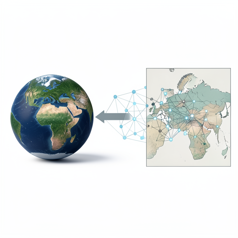
Geo AI Conceptual Framework
AI-generated conceptual illustration (A digital representation of Earth's surface and a neural network architecture). It explains the idea and does not show study data.
View source evidence ↗Figures & tables
From the original paper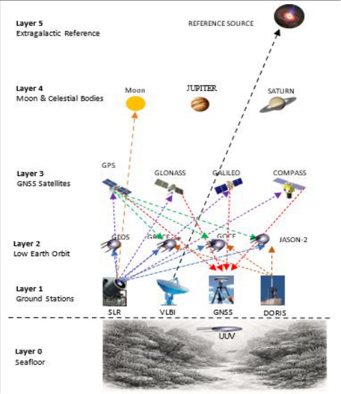 Figure 1
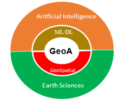 Figure 2
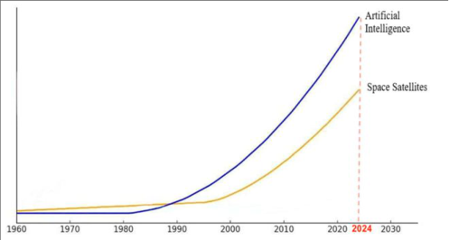 Figure 3
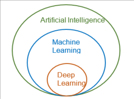 Figure 4
 Table 1
 Table 2
Introduction
Geospatial technologies and equipment are becoming increasingly advanced, allowing the acquisition, exploitation, and processing of increasingly rich and diverse datasets with improving quality and lower costs. Thanks to prominent advantages such as rich information content, short data acquisition cycles, and large-area coverage, geospatial technologies and data have become effective tools for monitoring changes in natural resource and environmental components across space and time. Geospatial technologies form a multilayer observation network (Figure 1). In addition to ground-based instruments, satellite technology is considered a key component in Earth observation. In low Earth orbit (LEO), besides remote sensing satellites such as Landsat, Sentinel, and SPOT, there are also gravity satellites and laser satellites dedicated to studying tectonic plate movements as well as determining sea-level rise in oceans and seas. GNSS systems, including GPS (United States), GLONASS (Russia), Galileo (European Union), and COMPASS (China), continue to be upgraded and improved in terms of both the number of satellites and signal strength. In recent years, the advent of Unmanned Undersea Vehicles (UUVs) has enabled effective, accurate, and timely seabed mapping and environmental monitoring. Geospatial technologies can operate independently or be integrated into multi-source, multi-resolution, and multi-temporal systems for monitoring natural resource and environmental components on a global scale. The continuous development of satellite systems and geospatial technologies has resulted in an explosion of data that far exceeds the capabilities of traditional analytical approaches or customized programming methods. These methods are unable to effectively process large, heterogeneous, and complex datasets. The emergence of Geo AI stems from the practical need to apply artificial intelligence to big-data processing in order to address urgent global challenges. The world currently faces complex issues requiring rapid response and accurate forecasting, including environmental pollution and degradation, climate change, urbanization, precision agriculture, smart infrastructure planning, and disaster management. In most of these domains, Geo AI serves as a tool for intelligent and real-time decision support. To date, commercial Geo AI models around the world are often regarded as "black boxes." For the Vietnamese geospatial science community, Geo AI remains a relatively new technology. This review study focuses on collecting and analyzing documents to evaluate technological architectures, technology combinations, data types, and application capabilities of Geo AI models. Scientific papers and reports from reputable domestic and international journals were reviewed, analyzed, compared, and synthesized to generalize the scientific foundations and methodologies of published studies, with particular emphasis on research outcomes and practical applications in agriculture and environmental management. Multi-layer observation system of geospatial technology [1]
Geo AI Technology
Geo AI is the abbreviation of Geospatial Artificial Intelligence, a term first introduced at a conference organized by the Association for Computing Machinery (ACM) Special Interest Group on Spatial Information (SIGSPATIAL) in Redondo Beach, California, USA. Since then, Geo AI has undergone continuous development and advancement. The emergence of Geo AI is an inevitable trend driven by the explosion of data, the increasing computational power of cloud computing and graphics processing units (GPUs), and especially the rapid advancement of artificial intelligence. Artificial intelligence had already been applied in Earth sciences in general and geography in particular. However, Geo AI truly emerged and evolved with the advent of machine learning and deep learning models capable of effectively processing large, diverse, and complex datasets. These models can automatically classify, analyze spatial information, extract features from raw data, perform generalization, and support transfer learning [2,3,14] (Figure 2). Geo AI is therefore positioned at the intersection of Earth sciences, geospatial science, and artificial intelligence, with machine learning and deep learning serving as its key enabling technologies. In the satellite sector alone, the past five years have witnessed unprecedented growth in both the volume of satellite-acquired data and the maturity of artificial intelligence techniques, particularly machine learning and deep learning algorithms capable of exploiting these datasets (Figure 3). As of May 2025, more than 12,000 active satellites orbit the Earth three times more than in 2020. Approximately one-third of these satellites are dedicated to Earth observation missions and continuously transmit petabytes of imagery every day [14] .
Technologies Used in Geo AI Machine Learning
Machine Learning (ML) is one of the fundamental components of Geo AI. Machine learning models are commonly applied to regression, classification, and clustering problems. Two major learning paradigms can be distinguished: supervised learning, where training data are labeled, and unsupervised learning, where labels are unavailable [3] . Typical machine learning models used in regression and classification tasks include Random Forest (RF), Decision Tree (DT), K-Nearest Neighbors (KNN), and Support Vector Machine (SVM).
Deep Learning
Deep Learning (DL) is a subfield of machine learning that employs multilayer artificial neural networks to learn complex data representations. Inspired by the structure of the human brain, neural networks consist of interconnected "neurons" whose weights are adjusted and updated during the training process.
Satellite Remote Sensing
Satellites orbiting the Earth collect enormous quantities of imagery data. As of May 2025, more than 12,000 active satellites were operating in orbit, three times the number recorded in 2020, transmitting petabytes of imagery data every day [14] . In recent years, satellite constellation technology has developed rapidly. With major advantages including multi-source sensor integration, high temporal resolution, and continuous coverage, satellite constellations such as DMC (Disaster Monitoring Constellation), RapidEye, Planet, and the THEIA network enable highly accurate, reliable, and near-real-time monitoring of changes in natural resources and environmental components on the Earth's surface.
Geographic Information Systems (GIS)
Traditional GIS analyses have long focused on describing and comparing spatial data. They enable the identification of relationships among spatial objects, land-use patterns, and the distribution of environmental and natural-resource factors. However, these analyses are largely static in nature.
In Geo AI, machine learning and deep learning algorithms analyze multidimensional and multitemporal GIS data, uncover trends, and detect nonlinear relationships. Geo AIenhanced GIS not only improves the accuracy of spatial analysis but also accelerates the processing of large datasets to near-real-time levels. Through integrated analytical tools, GIS supports a transition from reactive problem-solving approaches to predictive methodologies, which are crucial for preventing and mitigating environmental impacts effectively.
Big Data
Big Data plays a central role in the "intelligentization" of geospatial data, not only by increasing data volume but also by enhancing analytical depth and processing speed. When combined with technologies such as GIS and remote sensing, Big Data provides a large-scale, multi-source infrastructure encompassing spatial and non-spatial data, as well as structured, semi-structured, and unstructured datasets.
Cloud Computing: Cloud computing provides the essential infrastructure for Geo AI development by enabling free or low-cost access to petabyte-scale data repositories and powerful analytical tools. Cloud computing not only addresses challenges related to massive data volumes and computational requirements but also fundamentally transforms the ways in which geospatial information is shared, accessed, and collaboratively analyzed.
Internet of Things (IoT)
Within the Geo AI ecosystem, the Internet of Things (IoT) functions as the "sensory system" that continuously collects real-world data in real time. If Big Data represents the "data warehouse" and artificial intelligence serves as the "brain," then IoT acts as the source of continuously updated and spatially explicit information from the physical world. The development of sensor technologies and cloud computing has enabled IoT to become an important data source, significantly enhancing Geo AI capabilities in natural resource management, environmental monitoring, and disaster prevention.
Blockchain
Blockchain is a foundational technology that ensures transparency, security, reliability, and decentralized data sharing within the Geo AI ecosystem. In Geo AI applications, data are collected from numerous sources such as UAVs, satellites, IoT devices, and GIS platforms. Blockchain serves as an auditing mechanism that verifies data provenance and prevents unauthorized modification or falsification. Owing to its distributed, immutable, and transparent characteristics, blockchain provides an effective solution for managing and exploiting geospatial data for environmental and natural-resource monitoring purposes.
Applications of Geo AI in Environmental Monitoring
The integration of large-scale geospatial datasets from multiple sources with machine learning and deep learning algorithms enables Geo AI to become an effective tool for real-time environmental monitoring and accurate prediction of environmental changes, including pollution, degradation, and environmental hazards.
Geo AI for Land Cover Change Monitoring
Geo AI is an effective tool for land-cover and land-use mapping, as well as for detecting land-cover and land-use changes over time. These thematic maps play a crucial role in environmental monitoring, spatial planning, and natural resource management. The application of artificial intelligence has significantly improved the speed, accuracy, and scalability of classification processes [16] . The application of deep learning algorithms, particularly Convolutional Neural Networks (CNNs), integrated with cloud-computing platforms such as Google Earth Engine (GEE), enables the automation of object extraction from remote sensing imagery. This approach provides a parallelprocessing solution for large satellite datasets, thereby substantially reducing analysis time. The advancement of Geo AI is reflected not only in computational efficiency but also in improvements in classification accuracy, the ability to distinguish a larger number of land-cover classes within a single observation period, and enhanced capacity for analyzing spatial and temporal dynamics [6,7,12] .
Geo AI for Environmental Pollution Monitoring
Geo AI is increasingly being applied to environmental pollution monitoring and emission-source identification, supporting activities related to air, soil, and water quality management as well as industrial emission control.
Traditional monitoring systems, which rely on fixed monitoring stations or sampling points for air, noise, and surface water, provide highly reliable data. However, monitoring networks are often sparse or unevenly distributed, and measurements are generally conducted periodically. In most cases, alerts are generated only when pollutant concentrations exceed regulatory thresholds. Geo AI enables the interpolation of values at unsampled locations, prediction of future pollution levels, and identification of pollution sources through the analysis of spatiotemporal emission patterns [10,13] .
Using data collected from IoT-based smart sensors, Geo AI algorithms can accurately monitor industrial emissions. Sensors record environmental parameters at five-minute intervals and transmit the data to AI models, where measurements are classified as either normal or anomalous.
After integration with GIS components, the propagation trajectories of pollutants can be mapped in real time. Geo AI can integrate transformer-based deep neural networks for sequential data processing with Long Short-Term Memory (LSTM) networks for temporal analysis, combined with hyperparameter optimization using Particle Swarm Optimization (PSO), to estimate difficult-to-measure environmental variables such as PM2.5 concentrations [15] . In the field of natural-environment pollution management, Geo AI also supports the detection of newly emerging pollution sources. The application of Convolutional Neural Networks (CNNs) or Random Forest (RF) models to radar imagery (Sentinel-1) and optical imagery (Sentinel-2) enables the identification of marine oil spills and illegal waste-disposal sites with high spatial and temporal accuracy [9] .
Table 2: Representative Applications of Geo AI in Environmental Pollution Monitoring [11] Monitoring [8] . Geo AI can extrapolate information from fragmented field observations and remote sensing datasets distributed across space and time, thereby providing a more comprehensive understanding of species distributions and habitat conditions. Geo AI is also applied in predictive conservation. AI models can integrate remote tracking data, such as GNSS sensor observations, with environmental information to forecast changes, risks, and negative impacts in advance, allowing proactive conservation interventions. Geo AI further supports the prediction of habitatdistribution shifts caused by climate change and extreme weather events. Neural networks are employed to model potential future refuges for different populations and identify areas likely to be affected by extreme climatic conditions. These analyses help prioritize regions requiring enhanced protection.
| Monitoring Target | Input Data | AI Algorithm | Spatial/Temporal Resolution |
|---|---|---|---|
| Industrial emissions | IoT, PM10, PM2.5, NOx | CNN | 30 km² / 5 minutes |
| Oil-spill pollution | Sentinel-1, Sentinel-2 | CNN | 10-30 m / day |
| Illegal waste dumps | Satellite imagery, terrain data | RF | 10-30 m / month |
| Pollution dispersion | Meteorological data, LU/LC, sensors | LSTM, XGBoost | Regional scale / month |
Table text extracted from the original PDF; superscript letters are shown inline. The original table image is below.
View original table image
In marine-environment studies, Geo AI is used to classify the conservation status of coral reefs based on imagery collected by underwater unmanned vehicles (UUVs) [5] . Convolutional Neural Network (CNN) models can identify stages of coral-reef degradation with an accuracy of 93%, demonstrating Geo AI's capacity to detect patterns beyond human perception [4] . In summary, Geo AI can optimize habitat management and biodiversity conservation activities, providing more effective support for conservation efforts in the context of rapidly changing environmental conditions.
Discussion
Discussion
Figures and tables from the paper
| Indicator | Traditional Methods | Geo AI |
|---|---|---|
| Processing time for 500 km² | 6-8 weeks | 72 hours |
| Land-cover classification accuracy | 76-80% | 92-95% |
| Number of land-cover classes identified | 5-7 | 9 |
| Change detection frequency | Periodic | Real-time |
Table text extracted from the original PDF; superscript letters are shown inline. The original table image is below.
View original table image
References
15 in the original paper- Vo CM, Vo ND. The role of geospatial technology and data in achieving the nation's new growth model objectives. In: Proceedings of the National Scientific Conference on Smart Geospatial Technologies in Natural Resource and Environmental Management. Hanoi: Institute of Geodesy and Cartography; 2024.
- Vo CM. Geo AI in achieving sustainable development goals. In: Proceedings of the National Scientific Conference on Geospatial Technology for Sustainable Development (NCGSD2024). Hanoi: Hanoi University of Mining and Geology; 2024.
- Nguyen PS, Nguyen QM. Geo AI: Technology and applications in geospatial science. In: Proceedings of the Scientific Conference on Smart Geospatial Technologies in Natural Resource and Environmental Management. Hanoi: Institute of Geodesy and Cartography; 2024.
- Aide TM, Corrada-Bravo C, Campos-Cerqueira M, Milan C, Vega G, Alvarez R. Real-time bioacoustics monitoring and automated species identification. PeerJ. 2013;1:e103.
- Aruna S, Thamarai M. Stressed coral reef identification using deep learning CNN techniques. Journal of Electronic & Information Systems. 2023;5(2).
- Biswas J, Jobaer MA, Haque SF, Shozib MSI, Limon ZA. Mapping and monitoring land use land cover dynamics employing Google Earth Engine and machine learning algorithms on Chattogram, Bangladesh. Heliyon. 2023;9(10):e21245.
- Chen H, Yang L, Wu Q. Enhancing land cover mapping and monitoring: An interactive and explainable machine learning approach using Google Earth Engine. Remote Sensing. 2023;15(18).
- Elith J, Leathwick JR. Species distribution models: Ecological explanation and prediction across space and time. Annual Review of Ecology, Evolution, and Systematics. 2009;40:677-697.
- Garcia-Pineda O, Holmes J, Rissing M, Jones R, Wobus C, Svejkovsky J, et al. Classification of oil spill thickness using multiple remote sensors. Remote Sensing of Environment. 2020;236:111421.
- Gonzales-Inca C, Calle M, Lavado-Casimiro W, Rau P, et al. Geospatial artificial intelligence (GeoAI) in integrated hydrological and fluvial systems modelling: Review of current applications and trends. Water. 2022;14(14):2211.
- Górniak G, Kunz M. Geo AI -analiza potencjału integracji systemów informacji geograficznej i sztucznej inteligencji w modelowaniu wybranych zjawisk środowiskowych. In: Środowisko przyrodnicze jako obszar badań. Vol. 7. Poznań: Bogucki Wydawnictwo Naukowe; 2025.
- Kang J, Zhang B, Dang A. A novel geospatial machine learning approach to quantify non-linear effects of land use and land cover change on carbon dynamics. International Journal of Applied Earth Observation and Geoinformation. 2024;128:103712.
- Razavi-Termeh SV, Sadeghi-Niaraki A, et al. Exploring multipollution variability in the urban environment: Geospatial AI-driven modelling of air and noise. International Journal of Digital Earth. 2024;17(1).
- United Nations. Mapping Disaster Resilience: Geo AI Best Practices from the UN-SPIDER Network. Vienna: United Nations Office for Outer Space Affairs; 2025.
- Zhang X, Cheng J, Luo P, Yang W. Random forest model for the estimation of fractional vegetation coverage based on a UAV-ground co-sampling strategy. Acta Scientiarum Naturalium Universitatis Pekinensis. 2020;56(4):695-704.