
Research article · 2026 · Full text
International Journal of Geography Geology and EnvironmentAssessment of Potential Geopark for Sustainable Tourism Development at Matheran Geopark, Raigad District of Maharashtra
Volume 8(7) · Pages 01–12 · DOI: 10.22271/27067483.2026.v8.i7a.799 ↗
Research areasGeotourism and Geoheritage ConservationUrbanism, Landscape, and Tourism StudiesDiverse Aspects of Tourism Research
Abstract
Author-writtenMatheran, a geologically fascinating lateritic hill station in the Raigad District of Maharashtra, is situated on a plateau on the western edge of the Deccan Volcanic Province at an elevation of around 800m. An attempt to assess its viability as a geopark site through field data and quantitative evaluation techniques are presented here, using a classification criteria derived from an inventory of geomorphological sites and their suitability ranking using GIS overlay techniques. Forty-two sub-criteria which fall under six major categories (Scientific value, Aesthetic value, Economic/functional value, Cultural value, Protection/management value and Tourism value) were evaluated. Strengths, Weaknesses, Opportunities and Threats (SWOT) with regard to sustainable geotourism and geopark development were also carried out. The results show that Matheran has overall average score of 30.83 and total score of 185 indicating its good potential to develop as a geopark. Lateritic cap rock, steep escarpments, panoramic views from various points, streamlets and water bodies, lush green forest cover and historic toy-train landscape contribute significant scientific and aesthetic values. It also proved resilient to tourism pressure, waste and the weak state of interpretation facilities and possesses ample scope to serve as a centre for community-oriented planning, environmental interpretation and education based geotourism development in Western Ghats.
Summary
Source-checkedPlain-language reading of the full paper, prepared with AI and checked against the text. Each point links to the authors' own words.
Why it matters
- Geodiversity refers to the variety of geological and geomorphological features and processes that support ecosystems, serving as the abiotic counterpart to biodiversity in conservation. View evidence ↗
- Geoparks are established as local units that combine conservation, education, and geotourism to support the sustainable development of local communities. View evidence ↗
- Matheran is a lateritic hill station located on a plateau at approximately 800m elevation on the western edge of the Deccan Volcanic Province in Maharashtra. View evidence ↗
The question
- The study aims to assess and characterize the scientific, aesthetic, economic-functional, cultural, protectional, and tourism values of Matheran as a geomorphosite. View evidence ↗
- The research seeks to perform a SWOT analysis to evaluate Matheran's potential for sustainable tourism development as a geopark. View evidence ↗
What they did
- Primary data was gathered via detailed field surveys, in situ observations, photography, GPS tagging, and field recording. View evidence ↗
- A unique ten-digit geocoding system was developed to classify sites based on spatial position, landform, preservation state, creation process, scientific importance, aesthetics, and management. View evidence ↗
What they found
- Matheran achieved a total score of 185 and an average score of 30.83, indicating strong potential for development as a geopark. View evidence ↗
- Aesthetic value was the highest-scoring domain (60), followed by scientific value (40). View evidence ↗
- The economic-functional value for geotourism was rated as moderate to high with a score of 28. View evidence ↗
- Tourism value was robust at 24, while cultural and protection-management values were moderate, scoring 18 and 15 respectively. View evidence ↗
- Major weaknesses identified include inadequate waste disposal, insufficient geological signage and planning, and difficulties managing the environment during peak seasons. View evidence ↗
- Critical threats include environmental degradation from unmanaged tourism, litter, informal developments on plateau edges, and erosion caused by climatic impacts. View evidence ↗
What it means
- The authors conclude that Matheran has very high potential for the development of geotourism and a geopark. View evidence ↗
- The authors recommend improving site management and interpretation infrastructure, specifically focusing on solid waste, crowd control, and road erosion. View evidence ↗
- The study notes a lack of strength in the current integration of cultural assets and the absence of long-term sustainability management plans. View evidence ↗
Visual summary
1 visualsIllustrations explain the paper; charts are replotted from the paper's own table values.
Score: 1. Scientific Values vs 2. Aesthetic Values vs 3. Economic/Functional... vs 4. Cultural Values vs 5....
Replotted from Table 1 (page 9) of the original paper. Every bar is the paper's own table value.
View source evidence ↗Figures & tables
From the original paper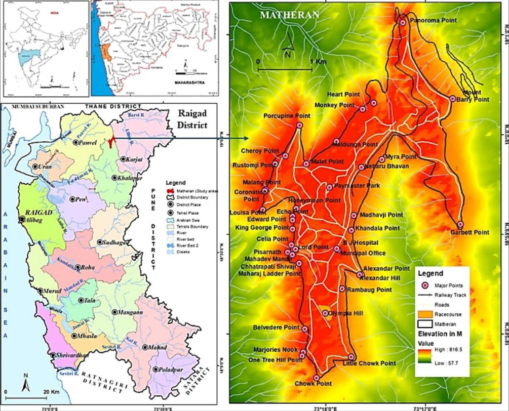 Figure 1
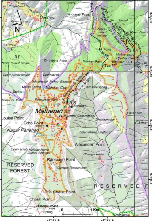 Figure 2
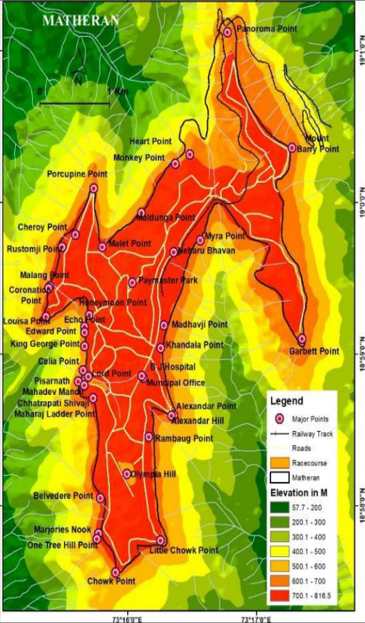 Figure 3
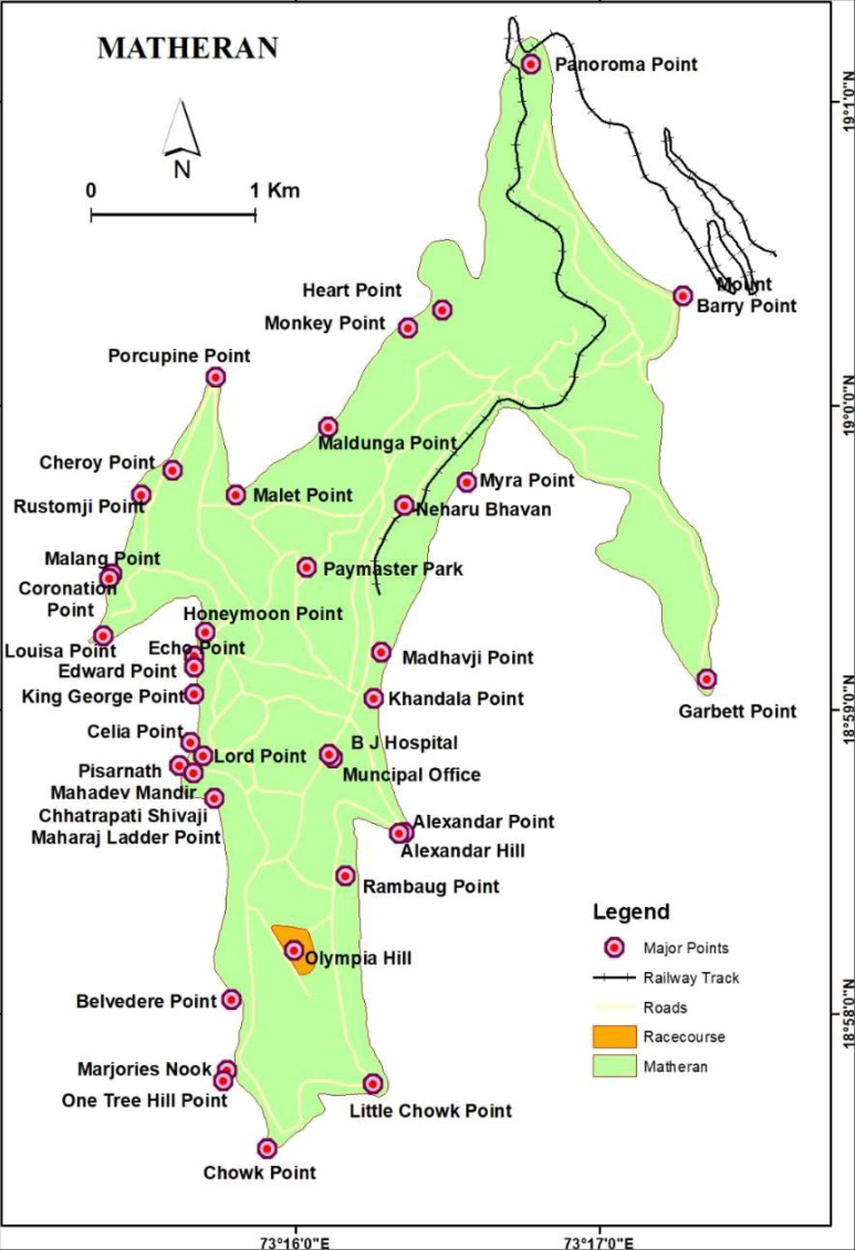 Figure 4
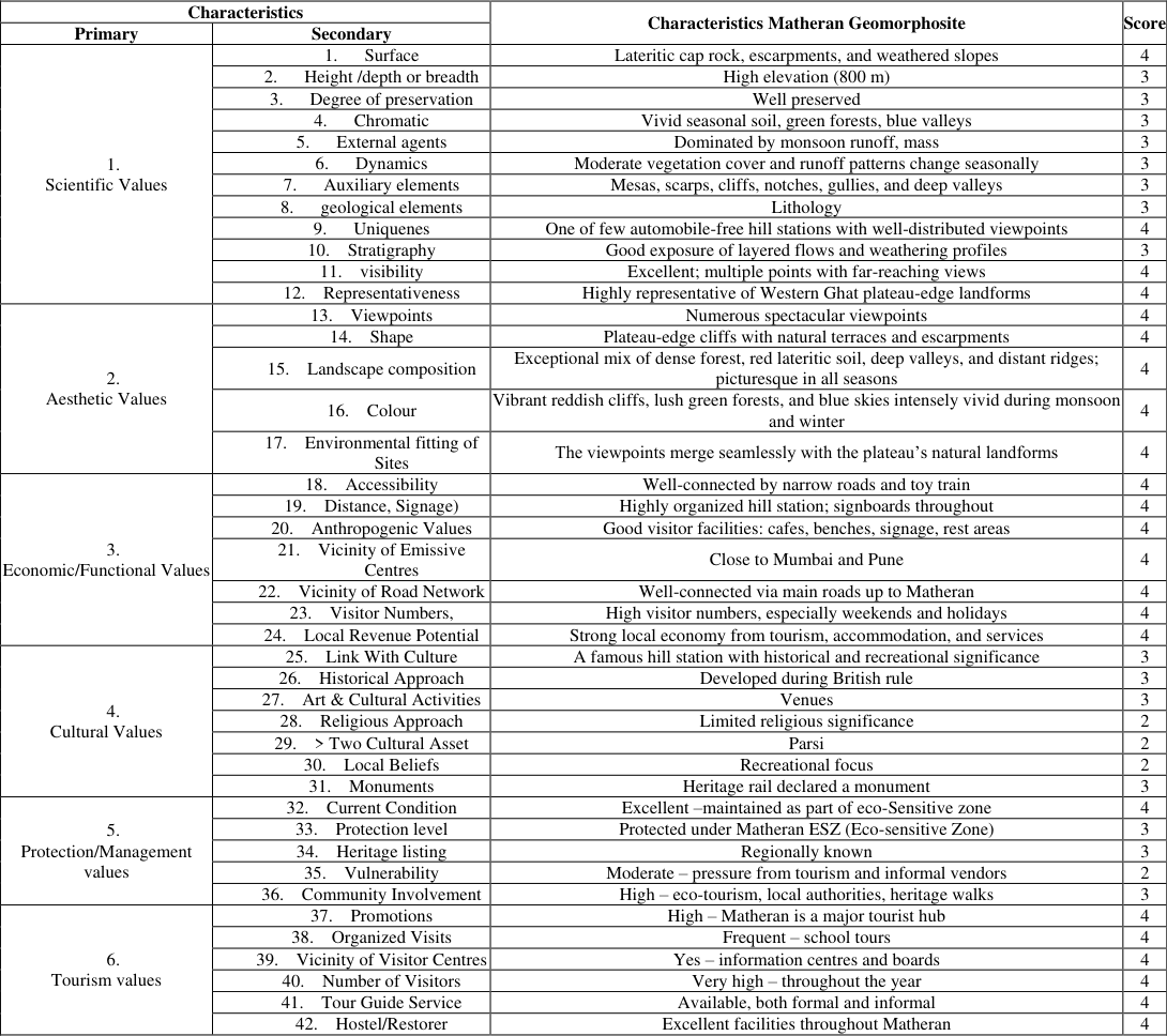 Table 1
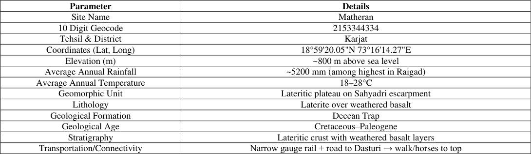 Table 2
Introduction
The elements of geodiversity with scientific, educational, aesthetic or cultural value are called geoheritage and thus require conservation (Brilha 2005; Gray 2013) [1,3,8] . Geodiversity is the diversity of geological and geomorphological features, materials and processes that underpin landscapes and ecosystems and is now being recognised as the abiotic equivalent of biodiversity in conservation and planning (Gray, 2013; Reynard & Brilha, 2018) [8,19] . In recent decades, geoparks have been developing as local units of conservation, education and geotourism of exceptional geological and geomorphological value, aimed at supporting sustainable development of the local community (Dowling & Newsome, 2010) [6] . Deccan Volcanic Province of western India is one of the biggest continental flood basalt provinces, and underlies the Western Ghats, with thick sequences of tholeiitic basalt flows overlaid by thick lateritic profiles (Subbarao, 1999) [9] . The Western Ghats escarpment and its associated palaeosurfaces and along the Konkan coast laterites and drainage patterns, are indicative of the Denudational history (Widdowson & Cox, 1996; Widdowson, 1997) [11] . Matheran falls under the larger context of a small hill station set on a basaltic mesa in the Karjat Taluka of the Raigad District on the western side of Western Ghats, 45-90 km from Mumbai, and 120 km from Pune (Information on Matheran, 2020; Department of Tourism Maharashtra, 2024) (Raigad District Administration, 2025). Matheran's mesa is separated from the main Western Ghats escarpment by the Konkan coastal plain, and surrounded by deep ravines and steep cliffs which form a ring of viewpoints and lateritic plateaus overlooking the surroundings (Information on Matheran, 2020; Government of Maharashtra, 2024) (Widdowson & Cox, 1996). The area of hill station and its surroundings has been identified as the Matheran Eco-Sensitive Zone (ESZ) with restrictions on industrial, developmental and vehicular activities required to ensure environmental integrity and the special plateau-escarpment system (Ministry of Environment and Forests, 2003; Ministry of Environment, Forest and Climate Change, 2017) [12] (Protection Act, 1986). Matheran is ecologically rich, with conservation-relevant taxa representative of the northern Western Ghats, and 140 butterfly species from 6 families were recorded on a mosaic of forested and open laterite plateaus, slopes, streams and valley forests over a long period of time (Sawant et al., 2020) [20] (Gadgil & Meher-Homji, 1990) [7] .On a larger scale, the lateritic plateaus of northern Western Ghats which developed on Deccan basalts have been identified as geologically unique and ecologically vulnerable, hosting widespread and threatened biota and being highly underdeveloped, often labelled as 'wastelands' (Gadgil & Meher-Homji, 1990) [7] (Reynard & Brilha, 2018) [19] . With unique volcanic geomorphology and high biodiversity, with protection of the ESZ and existing nature oriented tourism, Matheran therefore is a promising candidate for the planning of a Geopark in Deccan Volcanic Province (DVP) according to (Newsome & Dowling, 2010; Reynard & Brilha, 2018) [13,19] .
The objectives of Study
Assessment and characterize the scientific, aesthetic, economic-functional, cultural, protectional and tourism values as a Geomorphosites of Matheran Geopark. Study of the attractiveness of key Geomorphic landscape features in the shaping of the geo-tourism potential of Matheran Geopark. A SWOT Analysis of Matheran Geopark for sustainable tourism development
Study Area
Located in Karjat Taluka of Raigad District, Matheran is a tiny automobile-free hill station on the West side of the Western Ghats in western India. [12] . New industries that generate pollution, large scale construction, quarrying and mining are limited within the ESZ and development within is subject to a zonal master plan and carrying capacity study to preserve the specialised plateau-escarpment topography and its ecological role. (Ministry of Environment and Forests, 2003; Down To Earth, 2018) [12] . The focus of the study area for this paper is the Matheran plateau and the immediately adjacent escarpments and valleys in the ESZ, which covers the main plateau surface as well as the lateritic tablelands, most of the viewpoints, forested slopes, valley forests, nonperennial streams and artificial reservoirs like Charlotte Lake. Lying in the tropical monsoon climate zone, it receives heavy rainfall in the southwest monsoon, dense vegetation and seasonal water bodies with typical annual rainfall more than 4000 mm and means annual temperature is mostly 23 °C (Gadgil & Meher-Homji, 1990; Information on Matheran, 2020) [7] . The geology of Deccan plateau, laterite cap rock, escarpments and gorges, high rainfall and preserved forest area secured Matheran as an ideal project area for assessing the geoheritage and geopark potential of the northern Western ghats (Information on Matheran, 2020; Bombay Environmental Action Group, 2024).
The focus of the study area for this paper is the Matheran plateau and the immediately adjacent escarpments and valleys in the ESZ, which covers the main plateau surface as well as the lateritic tablelands, most of the viewpoints, forested slopes, valley forests, nonperennial streams and artificial reservoirs like Charlotte Lake. Lying in the tropical monsoon climate zone, it receives heavy rainfall in the southwest monsoon, dense vegetation and seasonal water bodies with typical annual rainfall more than 4000 mm and means annual temperature is mostly 23 °C (Gadgil & Meher-Homji, 1990; Information on Matheran, 2020) [7] . The geology of Deccan plateau, laterite cap rock, escarpments and gorges, high rainfall and preserved forest area secured Matheran as an ideal project area for assessing the geoheritage and geopark potential of the northern Western ghats (Information on Matheran, 2020; Bombay Environmental Action Group, 2024).
Materials and Methods
Materials and Methods
Database and sources
The present work relies upon primary and secondary sources for the purpose of identification, classification and geomorphosite evaluation of Matheran. Primary data was collected from different parts of the area through detailed field survey, in situ observation, photography, GPS tagging and field recording. Secondary data included the topographic sheets of Survey of India, (Fig. 2) maps of Geological Survey of India, satellite imagery of the study area, available statistics of tourism, published and non-published literature on the Matheran region and its eco-sensitive zone to delineate landforms, landforms elements and their present state, and to develop the information relating to accessibility, and visitor management. (Coratza & Giusti, 2005; Reynard et al., 2010) [5] .
Sampling strategy
A selective method of sampling was adopted to select geomorphosites in Matheran. Geomorphosite locations were selected on the criteria of landforms being exposed, scientifically significant, of scenic beauty, of tourist significance and being accessible (Coratza & Giusti, 2005; Reynard et al., 2010) [5] . Selected sites included landforms occurring on the plateau surface and at the escarpment edge. (Fig. 2) A diversity of geomorphosite occurrences, for example plateau surfaces, escarpment edges, view-points, slope of the escarpment, water features, and culturally relevant geomorphic elements was selected. (Coratza & Giusti, 2005; Reynard et al., 2007) [5,18] .
Ten-digit geocoding of geomorphosites
A ten-digit system for the coding of geomorphosites in Matheran was developed. Geomorphosite was given a unique ten-digit geo-code, representing its spatial position, form of landform/ geomorphic process of occurrence, state of preservation, the geomorphological process that created it, its scientific importance, the aesthetic character and its management relevance. This facilitates the classification and the spatially related interpretation and potential geotourist mapping of the geo-morphological sites (Kale, 2018) [10] .
Seven-value geo-assessment framework
In view of evaluating the geomorphosites for their geo-heritage value and their potential in geotourism, the author has proposed a seven-value assessment framework as different to the MGAM (Modified Geosite Assessment Model). The framework comprises six primary value categories that can be divided into forty-two sub-categories which will serve to ensure a locally suited and more balanced assessment (Vujičić et al., 2011; Tomić & Božić, 2014) [22,21] . The six values are: Scientific value, Aesthetic value, Economic values, cultural values protectional values, tourism values each broad value can be subdivided into six sub-values leading to a total of 42 sub-values.
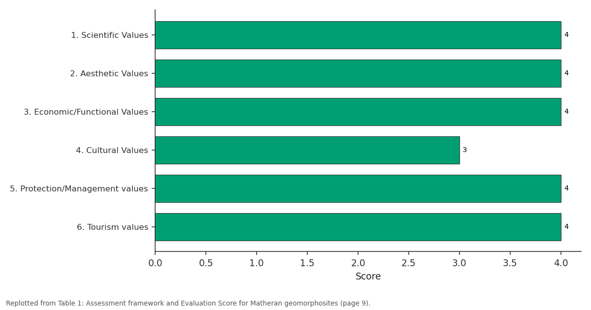
Each of these could be scored from 0-4, with 0 being of negligible value and 4 being of highest value. The summation of scores for each primary category and then the combined total provides the assessment value for a site.
Scoring procedure
Field assessment data of selected geomorphosite has been collected using a customized scoring sheet based on the six value assessment and its respective sub categories (6 values, 42 sub-values). Data for each sub-category for selected geomorphosites were scored ranging from 0-4 according to observation and information obtained in the field, and local perception (Reynard et al., 2007; Pereira et al., 2007) [18,14,15] . Data is summated first per value (i.e. scientific, aesthetic value, etc.) then for each site (Reynard et al., 2007; Vujičić et al., 2011) [18,22] , to ascertain comparative geoheritage value and geo-tourism potential. (Reynard et al., 2010; Chakrabarty & Mandal, 2022) [16] .
Tourist Points
Geomorphological the tourist points that can be described are concentrated on the edge of the lateral plateau, around a welldeveloped network of locations where the landscape can be observed. provides more than thirty labelled tourist points, the majority of which also serve as geomorphosites given the extent they demonstrate landforms such as the edges of plateau areas, lateritic caps, escarpments, and valleys(Reynard et al., 2010;
Bruschi & Cendrero, 2005) [4] . Most of these sites are characterized by open views and facilitate visitors' observation and interaction with landforms, and therefore they make Matheran a significant tourist resort for hiking, trekking, and photography, besides its educational and recreational value (Reynard et al., 2007; Newsome & Dowling, 2010) [18,13] . Panorama Point, Porcupine Point (also known as Sunset Point), Louisa Point, Echo Point, One Tree Hill, and Alexander Point are considered outstanding among these locations, (Fig. 3) as for their aesthetic and educational value (Reynard et al., 2007; Chakrabarty & Mandal, 2022) [18,16] . Panorama Point is seen as very important for appreciating slope development in the mornings and it is also very popular during the summer season. Porcupine Point offers stunning views of the surrounding scenery and the sunset, due to the distinctive landscape formation in the area and for its great aesthetic value as one of the major beauty spots of the plateau. [18] . Other places such as Belvedere Point, Honeymoon Point, Khandala Point, Mount Barry Point, and Little Chowk Point give panoramic views or illustrate the landforms of the edges of plateaus and valleys. The list of points available on Matheran, including those mentioned, not only includes popular and well-documented locations but it highlights the importance of an array of smaller, less described sites scattered on the edges of the plateau where landforms can be observed or studied. From a geomorphological perspective, this distribution of tourists' interest on the boundaries of the plateau landscape allows for the analysis and direct observation of landforms developed on the caps of laterites and under the controls of basaltic rocks underlying these layers (Widdowson & Cox, 1996; Subbarao, 1999/2019) [9] . [13] . Tourism in Matheran as a nature based activity the tourist character of Matheran is linked with its geomorphology, biodiversity and heritage; rather than the development of conventional urban activities for leisure and entertainment. The available tourist offer and related landscape attributes, such as lateritic terrains, green areas, cultural routes and natural formations such as lakes or waterfall locations are central in Matheran's image as a tourism destination for activities related to nature based and low-impact tourism(Reynard et al., 2007) [18] .
1-Ehco Poin Mandal, 2022) [16] . Matheran's easy accessibility is reinforced by its proximity to Mumbai and Pune and by available infrastructure restaurants, rest homes, accommodation, guide services, information located at Matheran (Department of Tourism Maharashtra, 2024; Times of India, 2024). Adventure and field school tourism is another very important element contributing to Matheran's tourism brand. Trekking paths leading to Garbett plateau, One Tree Hill, Dodhani, Panorama Point, and Charlotte Lake help students to develop hands-on experiences in direct contact with landscape elements such as escarpments, forest patches, streams, rock exposures and slopes that are particularly suitable for field training in geomorphology, biology and environmental studies (Department of Tourism Maharashtra, 2024; Newsome & Dowling, 2010) [13] . Hydrology, a great feature of this landscape the water resources are indeed one of the most important tourist attractions in Matheran. Streams carrying seasonal rain water, rivulets, waterfalls and water bodies are common landscapes shaped by climatic conditions, primarily by monsoon rainfalls, and are also intimately related to the geology of the plateau (Reynard et al., 2007; Widdowson & Cox, 1996) [18] . Charlotte lake, which represents the major local water body for the population and is an excellent water site for tourism, is along one of the tourist paths leading to Panorama Point and Echo Point and helps to explain and demonstrate water management and processes such as concentration of run-off on the plateaus and valley development as a result of drainage processes that have cut into the laterite cap and underlying basalt. There are several waterfalls that create scenic opportunities and attract many visitors during the monsoon season, providing good examples for understanding water erosion and slope-wash, channel incision and hydrological cycle in a natural setting (Department of Tourism Maharashtra, 2024; Reynard et al., 2007) [18] . These hydrological features contribute to the development of scenic tourism and they have a relevant scientific significance for the understanding of processes like erosional activity, discharge dynamics, or runoff generation in catchments that are well framed within an eco-topographic environment such as a high-plateau landscape. The human factor Matheran's touristic values are enhanced by its history and the surrounding cultural setting. The location developed as a summer resort for the British colonists, so there is a strong evidence of colonial architecture in its pathways, resting facilities, houses and the toy train line. Besides the colonial history there are also religious places, small temples and sacred groves that contribute to the sense of local tradition and community identity which attracts visitors to visit the area. In terms of accessibility Matheran offers a variety of choices. Its connection via the train line of the toy train or by car or bus through Neral is common choices. For internal access within the plateau, travellers can take a horse ride or use the specific carts pushed by local workers.
Results
The overall quantitative geomorphosite assessment of Matheran places it as an area of high geoheritage value and significant geopark potential (Reynard et al., 2007) [18] . [22] . Among the six value domains, aesthetics is scored the highest (60), followed by scientific (40), a factor that relates to the striking lateritic plateau cap, steep escarpments, imposing basaltic cliffs and visually impressive panoramas and varied viewpoints which include, Panorama point, Louisa point, Echo point, Porcupine Point and One Tree hill, all supported by impressive, seasonally dramatic colour changes along with lateritic plateau edge landforms (Reynard et al., 2007; Bruschi & Cendrero, 2005) [18,4] . The site's economic-functional value (28) for geotourism is moderate to high based on the local factors of ease of access, strong visitor appeal and the local economy which benefits greatly from tourism along with the provision of access routes, transportation, lodging facilities and supporting services(Chakrabarty & Mandal, 2022; Reynard et al., 2010) [16] . The tourism value (24) is similarly robust, reflecting a location where tourism, including interpreting, education and leisure are well established. The cultural [18] and protection-management values [15] , the latter primarily a combination of external protective measures and internal sustainability controls, are both moderate, and indicate area for future work. Although there are strong cultural and historic assets at Matheran; colonial buildings, heritage train lines, religious sites and strong local traditions they have not been brought into the heritage narrative (Newsome & Dowling, 2010) [13] . [12] . From the detailed scores, Matheran stands out positively in uniqueness, visibility, representativeness, viewpoints, landscape composition, colour contrast, ease of access, and proximity to population centres, visitor numbers, potential revenue, current status, promotion efforts, and visitor organization, quality of interpretation services and visitor accommodation and hosting (Reynard et al., 2007; Bruschi & Cendrero, 2005) [18,4] . Those areas scoring lowest are the value placed on the cultural and economic factors in religion, overall multiplicity of culturally significant items at sites, site vulnerability to degradation, and length and long-term sustainability of interpretation plan, the site appears to have highest strength in the scientific and aesthetic categories, tourism appeal and physical accessibility, and the least potential to draw on aspects of its cultural value to support a geopark interpretation plan and to protect it adequately from negative impacts of uncontrolled development and mass-tourism use (Reynard et al., 2007; Reynard et al., 2010) [18] . The SWOT (Strengths, Weaknesses, Opportunities, and Threats) analysis has highlighted that the lateritic plateau geology, dense vegetation and excellent viewpoints provide strong geological and natural values, along with unique car-free environment and accessibility to large metropolitan areas such as Mumbai(Newsome & Dowling, 2010; Department of Tourism Maharashtra, 2024) [13] . Conversely, the major weaknesses are inadequate waste disposal systems, insufficient geo interpretative signage and planning; difficulty with environmental management at peak seasons, and a lack of organized engagement of specific geoscientific principles and heritage interpretation to guide and inform visitor. Key opportunities centre on developing centres for geoscience interpretation and education with geo interpretative trails, digital heritage mapping and potentially integrating the site into existing wider regional geotourism routes (Chakrabarty & Mandal, 2022; Newsome & Dowling, 2010) [16,13] . The critical threats to Matheran centre on environmental degradation due to tourism and unmanaged development, litter pollution, informal developments along the escarpments and plateau edge and climatic impacts causing erosions (Ministry of Environment and Forests, 2003; Reynard et al., 2007) [12,18] .
SWOT Analysis of Matheran
Strengths Weaknesses Opportunities Threats Lateritic plateau and the escarpments, cliffs, valleys, waterfalls.
Lack of signage & geological information on site.
Design and establishment of geotrails, display boards and visitor interpretation.
Excessive tour operations resulting in ground erosion and site litter and pollution.
Excellent scientific, scenic and educational value.
Inadequate management systems for waste and people management in busy periods.
Promotion of community based geotourism and economic development of the region.
Extension of the infrastructure could destroy delicate terrain on the plateau itself.
A zone that permits zero vehicle access and the promotion of non-impact tourism.
During peak tourist season trails/viewpoints/sensitive slopes become worn down.
Promotion of community based geotourism and economic development of the region.
The intense rainfall, likely resulting from climatic change, can exacerbate landslides and slopes.
There are more than 30 highly scenic viewpoints.
Tourist facilities & interpretation at site areas could benefit from improvement in planning & maintenance.
Connectivity with Western Ghats eco-tourism circuits.
Pressure arising from the unregulated commercial activities on informal basis can detract from scenic qualities.
Easy access from Mumbai & Pune.
Poor visitor understanding of geological heritage.
Utilizing it as a learning landscape for students and research professionals.
Vegetation could decline, diminishing scenic qualities of the areas.
The heritage toy train and the colonial environment offer added appeal.
Undocumented commercial activity with localised impacts.
Conservation support by integrating conservation activities
Erosion and degradation could also arise from informal commercial activities and from intense pressure on viewing and trekking opportunities.
Discussion
The geological and landforms significance of Matheran are undoubtedly well established, not only as a tourist destination but also as a significant geomorphological region of tropical plateau edge landforms over the Deccan Traps, particularly highlighting erosion, weathering and denudation processes which continue till today (Widdowson & Cox, 1996; Subbarao, 1999) [9] . These findings are critically important because scientific and aesthetic values are the foundation upon which geopark status rests, as these are integral for geoconservation and for the public communication of the unique geology and landforms which support this status, via public interpretation, education and a focus on the value of landscapes to inspire appreciation for geological heritage (Reynard et al., 2007; Newsome & Dowling, 2010) [18,13] . That the Matheran has also inherited the pragmatic foundations necessary for the success of any geopark is clearly evident, having a well-developed transport network, strong links to major urban areas and a history of tourism that has created an industry around the site and many existing visitor management systems(Department of Tourism Maharashtra, 2024; Newsome & Dowling, 2010) [13] ; in an existing eco-sensitive zone status is an added advantage, as it establishes a strong policy basis for a more sustainable geopark in an already managed natural area, contrasting with many aspiring parks that have few protected legal designations(Ministry of Environment and Forests, 2003) [12] . It is significant that the analysis has brought forth the synergistic benefits of this area for conservation, science and tourism in an interconnected manner, The lateritic geology and plateau and escarpment forms of Matheran are not merely a beautiful backdrop and scientific spectacle, but provide a diverse, multitiered, functioning ecosystem that includes various species of endemic flora and fauna as well as the important geological processes, a fact strongly encouraged by the UNESCO global geopark concept, whereby diverse elements are woven to form the heritage value of a site(Reynard et al., 2007) [18] . At the same time, the only area where Matheran shows less strength is in its current use of cultural assets and long term sustainability management plans. It possesses many culturally rich facets and historic layers ranging from early colonial influences on land use through to more recent cultural practices and indigenous heritage that are not integrated into a planned geo interpretative context. Also whilst enjoying legislative protection the site has considerable problems with management of uncontrolled tourism such as litter, path erosion, footpath congestion, and lack of appropriate visitor facilities to cope with peak pressures which are of critical concern in ensuring that Matheran not be negatively impacted by potential geopark growth and interpretation strategy development(Newsome & Dowling, 2010) [13] . These are typical and recognizable problems in many geopark aspirants that have pre dated a formal geoheritage policy.
Matheran as a Potential Geopark
Matheran fits in to a good candidate of a geopark, by meeting several of the main requirements for developing a geopark namely: geologic uniqueness, unique landscape, potential for tourism and education, environmental sensitivity, potential linking of conservation with development (Newsome & Dowling, 2010; Reynard et al., 2010) [13] . The lateritic plateau on Deccan basalts at Matheran has a very unique geomorphological feature with escarpments, mesas, cliffs, valleys, lateritic surfaces and panoramic vistas of a wide geoheritage complex of both scientific and Aesthetic value (Subbarao, 1999; Widdowson & Cox, 1996) [9] . The major reason why Matheran would qualify as a geopark is its immense scientific value (Widdowson & Cox, 1996; Reynard et al., 2007) [18] . The plateau represents a sequence of lateiritisation, tropical weathering, retreat of cliffs, and incision of drainage and plateau edge geomorphology. Hence it forms a unique natural laboratory for the study of the Deccan volcanic landscape, its processes and features and how these may have evolved through the Tertiary into the present day as part of the Western Ghats (Reynard et al., 2007; Newsome & Dowling, 2010) [18,13] . [4,16] . Matheran also displays very high scenic and geotourism value, a crucial aspect of developing any potential geopark. The sheer concentration of view-points from edge the steep escarpments over to the deep wooded valleys, seasonal waterfalls and red lateritic slopes and panoramic views over the Konkan lowlands gives a highly aesthetically pleasing landscape where huge numbers of tourists throng annually. Since there is already an existing tourism structure in Matheran there is no question of beginning it from zero, but it is one of reforming an already established tourism into a more conservation conscious, science oriented and responsible geotourism. Matheran's greatest strength comes from the interaction between geoheritage, biodiversity and culture within the Matheran landscape. The plateau is not only of geo morphological interest, but it is also a critically sensitive area in its own right with its abundant flora, wildlife habitats, a typical wet seasonal hydrology and its regulated Eco-Sensitive Status.
Besides the scientific and natural significance, the town itself houses colonial architectural heritage, a historic toy train service, sacred places of pilgrimage, an iconic trekking trail and a vibrant tourist based livelihood pattern. These elements can collectively give Matheran a comprehensive geopark identitythat is integrating geology not in isolation, but as an important aspect of a broader ecological, cultural and social contextwhich is the modern day geopark development concept. Matheran has already in place an Eco-sensitive Zone. This makes its development as a geopark far easier, as the basic management infrastructure already exists. It includes restrictions on harmful development in sensitive areas, clear protection mechanisms, the public recognition of conservation as an important role and this means that Matheran can begin work on the complex tasks of site and heritage management. Private vehicular traffic is absent in the core region which means a reduction in a common source of disturbance and damage to a vulnerable landscape (Ministry of Environment and Forests, 2003; Department of Tourism Maharashtra, 2024) [12] . Therefore, with a systematic inventory and data compilation, a proper Geoconservation Management Plan, effective site interpretation centres and guided activities on Geo trails and well defined local engagement policies and programmes it would be possible to evolve Matheran into a Lateiritic plateau Geopark in the Western Ghats, probably one of the more dominant candidates in future Indian Geopark proposals (Reynard et al., 2010; Newsome & Dowling, 2010) [13] .
Conclusion
The present study shows that the Matheran is a strong site from geological scientific, aesthetic, economic-functional, cultural, protection and tourist value points of view and shows great potentiality as a geoheritage site in Raigad District of Maharashtra. With a total score 185 and an average score of 30.83 from a set of 42 sub category evaluation of parameters for geoheritage site, Matheran is determined to be a very high potential for the purposes of development of geotourism and for geopark oriented development. The best parts of Matheran are the lateritic plateau morphology, basaltic escarpment formations, panoramic views, thick green cover and excellent contrasts of colour combinations as well as the carfree tourism concept with its proximal nature with the larger population centres are key features giving both geological and aesthetic values, supporting sustainable tourism and environment education. Also, the Ecologically Sensitive Zone status and Heritage hill station identity helps integrate nature and the community towards conservation oriented sustainable development of the hill resort. However, in order to propose it as a ready geo-park candidate, a good development strategy needs to be taken. Scores achieved in the case of cultural and protection-management is moderate in comparison. A more geoscientific interpretation along with site-specific development of trails for visitors to see various geo-formations in a systematic manner as well as greater awareness programmes for the local population regarding heritage and environmental conservation need to be undertaken. Management with emphasis on better site management practices and more interpretation infrastructure should focus on managing solid wastes, informal tourist crowd, road erosion due to excessive traffic etc. This can be achieved through more collaborative development of such a unique and fascinating latterite plateau geo-form in a sustainable way in the context of the developed geopark development system and community participation at the development of the area into an ideal conservation based geo-park in western India in near future.
Figures and tables from the paper
| Characteristics | — | Characteristics Matheran Geomorphosite | Score |
|---|---|---|---|
| Primary | Secondary | ||
| 1. Scientific Values | 1. Surface | Lateritic cap rock, escarpments, and weathered slopes | 4 |
| 2. Height /depth or breadth | High elevation (800 m) | 3 | |
| 3. Degree of preservation | Well preserved | 3 | |
| 4. Chromatic | Vivid seasonal soil, green forests, blue valleys | 3 | |
| 5. External agents | Dominated by monsoon runoff, mass | 3 | |
| 6. Dynamics | Moderate vegetation cover and runoff patterns change seasonally | 3 | |
| 7. Auxiliary elements | Mesas, scarps, cliffs, notches, gullies, and deep valleys | 3 | |
| 8. geological elements | Lithology | 3 | |
| 9. Uniquenes | One of few automobile-free hill stations with well-distributed viewpoints | 4 | |
| 10. Stratigraphy | Good exposure of layered flows and weathering profiles | 3 | |
| 11. visibility | Excellent; multiple points with far-reaching views | 4 | |
| 12. Representativeness | Highly representative of Western Ghat plateau-edge landforms | 4 | |
| 2. Aesthetic Values | 13. Viewpoints | Numerous spectacular viewpoints | 4 |
| 14. Shape | Plateau-edge cliffs with natural terraces and escarpments | 4 | |
| 15. Landscape composition | Exceptional mix of dense forest, red lateritic soil, deep valleys, and distant ridges; picturesque in all seasons | 4 | |
| 16. Colour | Vibrant reddish cliffs, lush green forests, and blue skies intensely vivid during monsoon and winter | 4 | |
| 17. Environmental fitting of Sites | The viewpoints merge seamlessly with the plateau’s natural landforms | 4 | |
| 3. Economic/Functional Values | 18. Accessibility | Well-connected by narrow roads and toy train | 4 |
| 19. Distance, Signage) | Highly organized hill station; signboards throughout | 4 | |
| 20. Anthropogenic Values | Good visitor facilities: cafes, benches, signage, rest areas | 4 | |
| 21. Vicinity of Emissive Centres | Close to Mumbai and Pune | 4 | |
| 22. Vicinity of Road Network | Well-connected via main roads up to Matheran | 4 | |
| 23. Visitor Numbers, | High visitor numbers, especially weekends and holidays | 4 | |
| 24. Local Revenue Potential | Strong local economy from tourism, accommodation, and services | 4 | |
| 4. Cultural Values | 25. Link With Culture | A famous hill station with historical and recreational significance | 3 |
| 26. Historical Approach | Developed during British rule | 3 | |
| 27. Art & Cultural Activities | Venues | 3 | |
| 28. Religious Approach | Limited religious significance | 2 | |
| 29. > Two Cultural Asset | Parsi | 2 | |
| 30. Local Beliefs | Recreational focus | 2 | |
| 31. Monuments | Heritage rail declared a monument | 3 | |
| 5. Protection/Management values | 32. Current Condition | Excellent –maintained as part of eco-Sensitive zone | 4 |
| 33. Protection level | Protected under Matheran ESZ (Eco-sensitive Zone) | 3 | |
| 34. Heritage listing | Regionally known | 3 | |
| 35. Vulnerability | Moderate – pressure from tourism and informal vendors | 2 | |
| 36. Community Involvement | High – eco-tourism, local authorities, heritage walks | 3 | |
| 6. Tourism values | 37. Promotions | High – Matheran is a major tourist hub | 4 |
| 38. Organized Visits | Frequent – school tours | 4 | |
| 39. Vicinity of Visitor Centres | Yes – information centres and boards | 4 | |
| 40. Number of Visitors | Very high – throughout the year | 4 | |
| 41. Tour Guide Service | Available, both formal and informal | 4 | |
| 42. Hostel/Restorer | Excellent facilities throughout Matheran | 4 |
Table text extracted from the original PDF; superscript letters are shown inline. The original table image is below.
View original table image
| Parameter | Details |
|---|---|
| Site Name | Matheran |
| 10 Digit Geocode | 2153344334 |
| Tehsil & District | Karjat |
| Coordinates (Lat, Long) | 18°59'20.05"N 73°16'14.27"E |
| Elevation (m) | ~800 m above sea level |
| Average Annual Rainfall | ~5200 mm (among highest in Raigad) |
| Average Annual Temperature | 18–28°C |
| Geomorphic Unit | Lateritic plateau on Sahyadri escarpment |
| Lithology | Laterite over weathered basalt |
| Geological Formation | Deccan Trap |
| Geological Age | Cretaceous–Paleogene |
| Stratigraphy | Lateritic crust with weathered basalt layers |
| Transportation/Connectivity | Narrow gauge rail + road to Dasturi → walk/horses to top |
Table text extracted from the original PDF; superscript letters are shown inline. The original table image is below.
View original table image
References
21 in the original paper- Brilha J. Geological heritage and geoconservation: nature conservation in its geological aspect. Palimage. 2005.
- Brilha J. Inventory and quantitative assessment of geosites and geodiversity sites: a review. Geoheritage. 2016;8(2):119-134.
- Brilha J, Andrade C, Azerêdo A, Barriga FJAS, Cachão M, Couto H, et al. Definition of the Portuguese frameworks with international relevance as an input for the European geological heritage characterisation. Episodes Journal of International Geoscience. 2005;28(3):177-186.
- Bruschi VM, Cendrero A. Geosite Evaluation; Can We Measure Intangible Values? Alpine And Mediterranean Quaternary. 2005;18(1):293-
- Coratza P, Giusti C. Methodological proposal for the assessment of the scientific quality of geomorphosites. Alpine and Mediterranean Quaternary. 2005;18(1):307313.
- Dowling RK. Geotourism: the tourism of geology and landscape. 2010.
- Gadgil M, Meher-Homji VM. Ecological diversity. In: Proceedings of the Centenary Seminar of the Bombay Natural History Society. Bombay Natural History Society and Oxford University Press; 1990:175-198.
- Subbarao KV. Deccan Volcanic Province, Volume 1Deccan Volcanic Province, Geological Society of India Issue 43 of Memoir (Geological Society of India) Volume 41; Volume 43 of Memoir / Geological Society of India, Geological Society of India, ISSN 0435-4001. 1999.
- Kale VS. Atlas of Geomorphosites of Maharashtra. Indian Intritute of geomorphologists; 2018.
- Widdowson M. Tertiary palaeo surfaces of the SW Deccan, Western India: Implications for passive margin uplift. Geological Society London Special Publications. 1997;120(1):221248.https://doi.org/10.1144/GSL.SP.1997.120.01.15
- Ministry Of Environment and Forests. Notification New Delhi, the 4th February. Notification of Matheran and surrounding region as an Eco-Sensitive Zone. 2003.https://faolex.fao.org/docs/pdf/ind52267.pdf
- Newsome D, Dowling RK. Geotourism: the tourism of geology and landscape. Oxford: Goodfellow Publishers; 2010.http://dx.doi.org/10.23912/978-1-906884-09-
- Pereira P, Pereira D. Methodological guidelines for geomorphosite assessment. 2007;215-
- Pereira P, Pereira D, Caetano Alves MI. Geomorphosite assessment in Montesinho natural park (Portugal). Geographica Helvetica. 2007;62(3):159-168.
- Chakrabarty P, Mandal R. Tourism Potentials of Fossil Parks as Geoheritage Sites: A Study in Western and South Western Region of West Bengal, India. 2022.
- Reynard E, Panizza M. Geomorphosites: definition, assessment and mapping. An introduction. Géomorphologie: relief, processus, environnement. 2005;11(3):177-180.
- Reynard E, Fontana G, Kozlik L, Scapozza C. A method for assessing scientific and additional values of geomorphosites. Geographica Helvetica. 2007;62(3):148158.
- Reynard E, Brilha J. Geoheritage: assessment, protection, and management. 2018.
- Sawant M, Sarang S, Modak N. Finding the forgotten gems: revisiting the butterflies of Matheran after 125 years with introduction to novel colour barcode for depicting seasons and activity of the Indian butterflies. Biodiversity Data Journal. 2020;8:e54333.
- Tomić N, Božić S. A modified geosite assessment model (M-GAM) and its application on the Lazar Canyon area (Serbia). International Journal of Environmental Research. 2014;8(4):1041-1052.
- Vujičić MD, Vasiljević DA, Marković SB, Hose TA, Lukić T, Hadžić O, et al. Preliminary geosite assessment model (GAM) and its application on Fruška Gora Mountain, potential geotourism destination of Serbia. Acta Geographica Slovenica. 2011;51(2):361-376.
Cited by 1
From OpenAlex, OpenCitations and reference lists read by Scinovex
- Assessment of Tourist Perceptions and Destination Loyalty for Promoting Sustainable Geotourism in Raigad District, Maharashtra, India ↗
Urmila Rajpurohit, Dnyaneshwar N Pawar · International journal of applied research · 2026
Geotourism represents an innovative strategy for combining the conservation of geodiversity, visitor education, and sustainable development in a region. This study investigates tourists' perceptions, destination loyalty, and geotourism potential in the Raigad District of the Konkan region of Maharashtra, India, a region abounding with a variety of geomorphological, cultural, and historical sites, beaches, coastal landforms, caves, waterfalls, hills, forts, and