
Research article · 2026 · Full text
International Journal of Horticulture and Food ScienceAutomated cloud motion tracking using satellite imagery and deep learning
Volume 8(7S) · Pages 01–09 · DOI: 10.33545/26631067.2026.v8.i7sa.771 ↗
Research areasAdvanced Neural Network ApplicationsRemote-Sensing Image ClassificationMeteorological Phenomena and Simulations
Abstract
Author-writtenCMT with clouds forms a critical aspect in the weather prediction, climatology, aircraft safety, and control of disasters. Conventional methods of cloud monitoring typically use the human interpretation and standard image-processing algorithms, which can be time-intensive and may not be as efficient to process a high number of satellite images. The research suggests a technical system of automated cloud motion tracking via satellite imagery and deep learning algorithms to enhance accuracy and efficiency in detecting, tracking, and predicting clouds. The overall methodology will involve the use of U-Net (cloud segmentation), Convolutional Neural Networks (CNNs) (spatial features), and Convolutional Long Short-Term memory (ConvLSTM) networks (temporal), robotically moving clouds. The satellite images of multiple periods undergo preprocessing steps of normalization, enhancement, noise reduction, and then proceed to be analyzed using the deep learning models. The model has high segmentation accuracy, valid cloud feature detection, and accurate forecasting of cloud movement in various atmospheric conditions as evidenced by experimental results. The combination model is very successful in both spatial and temporal features to represent clouds, and make up the proper estimation of cloud courses, and future cloud locations. Accuracy, Precision, Recall, F1-Score and root mean square error (RMSE) performance analysis proves the usefulness of the suggested method. The results show that deep learning cloud motion monitoring can greatly improve the short-term weather forecasting and surveillance functions. The suggested framework offers an intelligent systemscaling approach to large-scale satellite datasets processing and it can facilitate the development of automated meteorological systems to predict weather.
Summary
Source-checkedPlain-language reading of the full paper, prepared with AI and checked against the text. Each point links to the authors' own words.
Why it matters
- Cloud motion tracking (CMT) is essential for critical applications including weather prediction, climatology, disaster control, and aircraft safety. View evidence ↗
- Traditional cloud monitoring relies on human interpretation and standard image-processing, which are often too time-intensive to efficiently handle large volumes of satellite imagery. View evidence ↗
The question
- The study aims to develop an automated cloud motion tracking system using satellite imagery and deep learning to improve the efficiency and accuracy of cloud detection, tracking, and prediction. View evidence ↗
What they did
- The proposed framework combines three deep learning models: U-Net for cloud segmentation, CNNs for extracting spatial features, and ConvLSTM networks for temporal analysis of cloud movement. View evidence ↗
- The dataset was partitioned into training (70%), validation (15%), and testing (15%) sets for model development and evaluation. View evidence ↗
What they found
- The U-Net model achieved high cloud segmentation performance, with a testing accuracy of 97.1%. View evidence ↗
- The CNN model effectively extracted spatial cloud features with an average accuracy of 95.6%. View evidence ↗
- Short-term cloud motion prediction was highly accurate, achieving 98.3% accuracy and an RMSE of 1.8 km for a 15-minute forecast horizon. View evidence ↗
- Prediction accuracy decreased as the forecast horizon increased, dropping to 92.7% with an RMSE of 6.8 km at 90 minutes. View evidence ↗
- The total average processing time for a set of images was 16.1 seconds, suggesting the framework is suitable for near real-time forecasting. View evidence ↗
What it means
- The authors conclude that the combined deep learning approach significantly outperforms traditional image-processing methods in cloud tracking performance. View evidence ↗
- Future work should explore transformer-based architectures, multi-satellite data fusion, and extended forecast horizons to further improve system functionality and accuracy. View evidence ↗
Visual summary
3 visualsIllustrations explain the paper; charts are replotted from the paper's own table values.
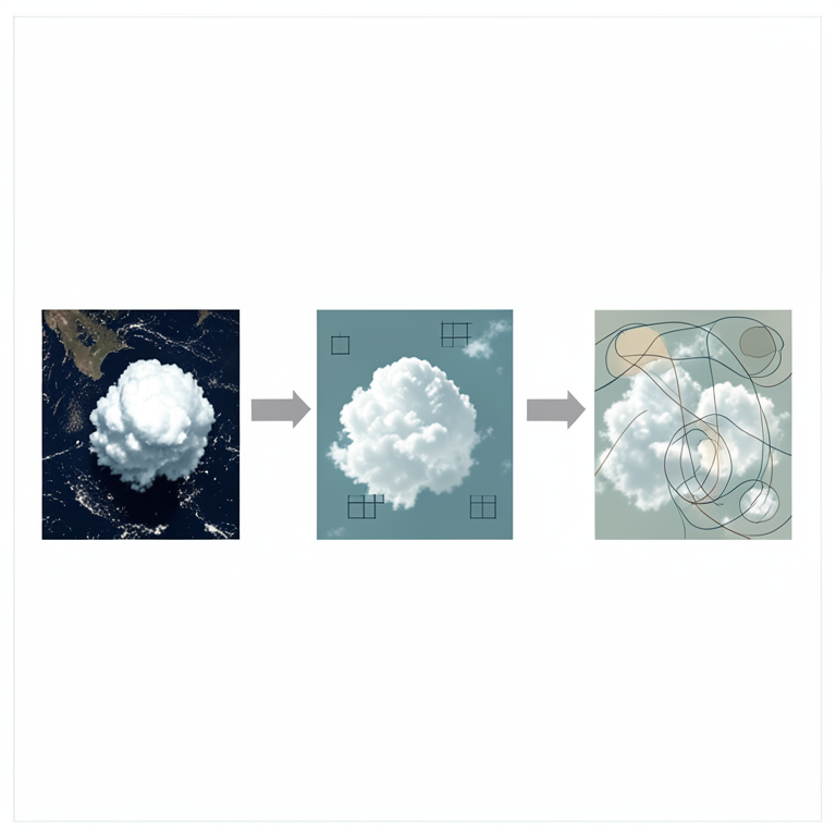
Deep Learning Pipeline for Cloud Tracking
AI-generated conceptual illustration (satellite imagery of clouds over Earth). It explains the idea and does not show study data.
View source evidence ↗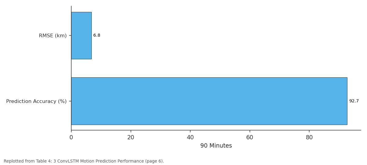
90 Minutes: RMSE (km) vs Prediction Accuracy (%)
Replotted from Table 4 (page 6) of the original paper. Every bar is the paper's own table value.
View source evidence ↗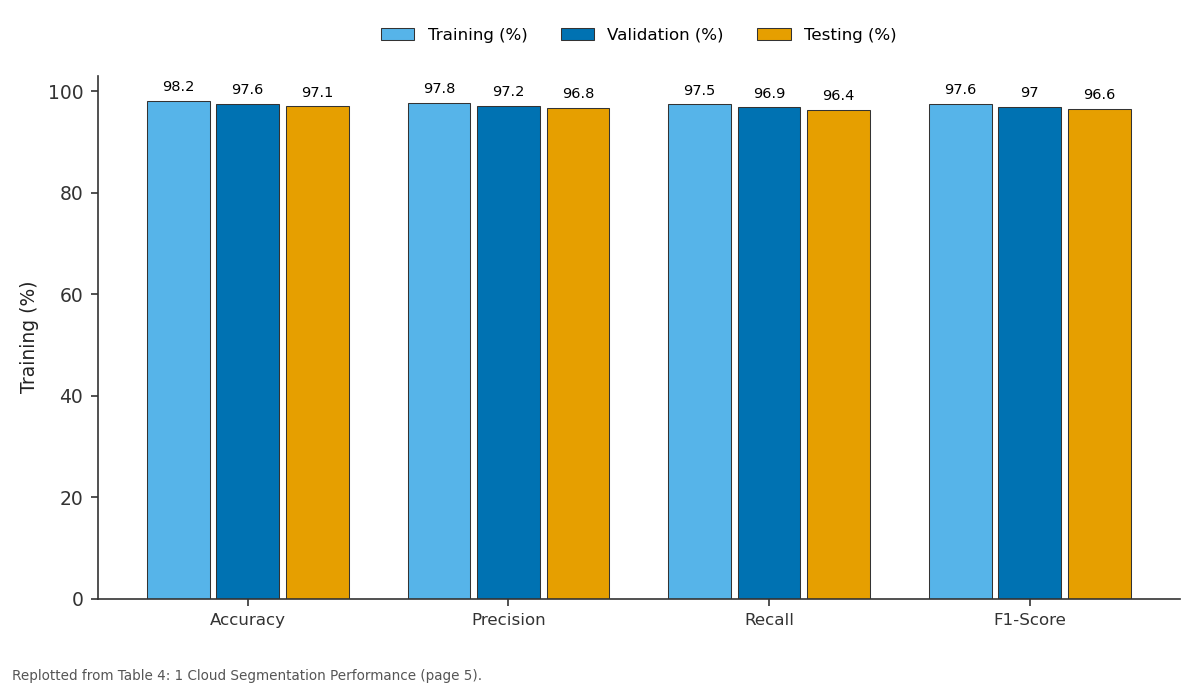
Training (%) and Validation (%) and more: Accuracy vs Precision vs Recall vs F1-Score
Replotted from Table 4 (page 5) of the original paper. Every bar is the paper's own table value.
View source evidence ↗Figures & tables
From the original paper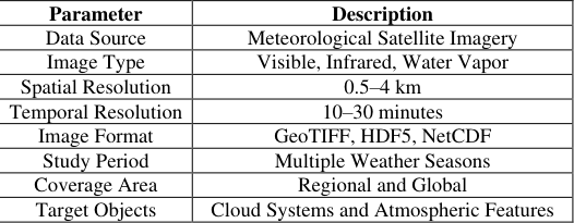 Table 1
 Table 2
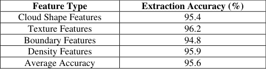 Table 4
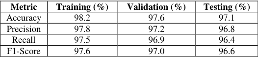 Table 4
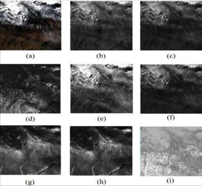 Figure 1
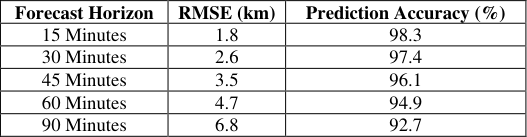 Table 4
 Table 4
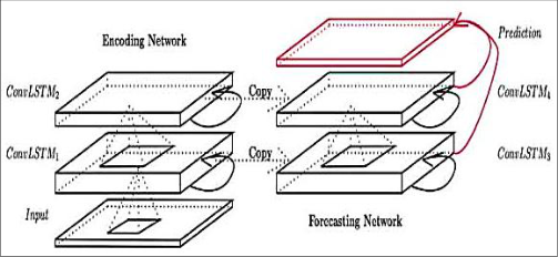 Figure 2
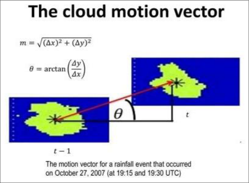 Figure 3
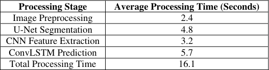 Table 4
 Figure 4
Introduction
The atmosphere of the earth is greatly impacted by clouds in various aspects as they affect the weather conditions, the ways in which it rains and the climatic conditions. Weather forecasting, disaster management, aviation safety as well as climate research require accurate tracking and monitoring of cloud movement. Conventionally, to monitor the movement of clouds and predict their future, meteorologists have used satellite images and optical flow. Nonetheless, taking out the satellite data in bulk, manually, is both time-and labor-intensive, and may not give real-time data which is essential in current forecasting systems [1] . The new developments in remote sensing technologies in satellites have led to the persistent creation of the high resolution and multitemporal Earth observation images. These data sets are useful in terms of cloud formation, movement and development in various geographical regions. Meanwhile, advancements in the field of artificial intelligence and deep learning have opened up new possibilities in automating the process of analyzing intricate visual patterns in the satellite photos. Convolutional Neural Networks (CNNs), Recurrent Neural Networks (RNNs), and Convolutional Long Short-Term Memory (ConvLSTM) networks, are deep learning models that have excelled in performing image recognition, object tracking, and spatiotemporal tasks like data analysis. Satellite images and deep learning.Automated cloud motion tracking seeks to use these technological developments to precisely track, detect and forecast cloud patterns [2] . Deep learning algorithms can produce cloud motion vectors, identify developing weather systems, and enhance the accuracy of short-term predictions by learning the spatial and temporal correlation using a sequence of satellite images. Such automated solutions lessen the reliance on manual interpretation and increase the efficiency and dependability of the meteorological observations [3] . This study aims at creating a deep learning model of a cloud motion tracking system based on satellite images and automated. The research aims at investigating the advanced image processing methods and machine learning in cloud detection and classification and estimation of motion. The results will be aimed at leading to better weather forecasting, better climate surveillance, as well as better usage of satellitebased Earth observation data towards environmental and atmospheric needs.
Methods and Materials 3.1 Research Methodology
The current paper suggests a satellite-based, deep learning, and automated cloud motion tracking system. The methodology incorporates the use of satellite images in the acquisition, preprocessing, cloud segmentation, extraction of features, estimating of cloud movement and predictive analysis. Multitemporal satellite images refer to the meteorological satellite platforms, which are used to capture multi-temporal satellite images and process them to understand the structure of the clouds and their motion patterns with time [4] . Side by side cloud sequences of images have spatial and temporal features which are learnt with deep learning models. The general workflow includes data collection, image processing, model training, cloud tracking, as well as the performance evaluation. The suggested framework should enhance the accuracy of estimating the cloud movements and minimize the usage of manual operation. Figure-independent processing can be used to continuously monitor the conditions of the atmosphere and provides application to short-term weather forecasting [5] .
Materials and Dataset
The main source of data in this research is taken using satellite imagery. Geostationary and polar bear satellites provide multitemporal cloud images to give an ongoing impression of the atmosphere. The pictures contain the visible, infrared, and water vapor channels, which have vital data concerning cloud formations and movement. The dataset will be segregated into training, validation and testing data sets so as to guarantee a sound model development and evaluation. Usually, 70 percent of the data is utilized in training, 15 percent in validation and 15 percent in testing.
Data Preprocessing
The noise on satellite images and the gaps of values, as well as the variations of the lighting, and the atmospheric distortions are a common thing [6] . Thus, before training models, preprocessing is carried out. The preprocessing phase consists of:
Normalization and resizing of images. Filtering to reduce noise. Enhanced contrast to gain more visibility of the clouds. Time synchronization of image sequences. Cloud mask generation. Rotation, flipping, scaling of data.
Normalization brings the pixel values to a unified range which enhances model convergence in training. The augmentation augments diversity in the datasets and rigorously boosts generalization capacity in the models.
Deep Learning Algorithms
Automated cloud motion tracking is achieved through the use of three deep learning algorithms.
Convolutional Neural Network (CNN)
CNN is applied in cloud detection and detection of features in satellite images. Convolutional layers can automatically learn spatial features like cloud boundaries, textures and shapes. The pooling layers minimize the computing process, but maintain significant data.
The CNN model derives the features of high level clouds, which is used as the input to future tracking and prediction. The model is learnt with the help of marked up images of clouds and refined by backpropagation [7] .
Advantages
Advantages
U-Net Segmentation Network
U-Net is used to make fine-tuned cloud segmentation. The architecture is an encoder decoder design with skip connections that conserve the spatial information when rebuilding images. Contextual cloud information is captured by the encoder, and pixel level cloud masks are produced by the decoder. U-Net is especially the most appropriate in remote sensing applications since it will effectively distinguish the areas of clouds and the background atmospheric features.
ConvLSTM Network
ConvLSTM is a frames / image sequence model that is relying on both convolutional processes and Long Short-Term Memory to simulate the relationships in both time and space in sequential satellite images. Contrary to the conventional LSTM networks, ConvLSTM does not lose spatial data during learning, and it also learns the temporal dynamics of cloud evolution. The network predicts the positions of clouds in the future, by using the past sequences of images and creates the cloud motion vectors [8] .
Proposed Framework
The suggested pipeline consists of the stages:
Step 1: Data Acquisition The satellite cloud images are gathered through meteorological databases.
Step 2: Preprocessing Images are normalized, enhanced and noise removed.
Step 3: Cloud Segmentation U-Net detects cloud regions, and produces segmentation masks.
Step 4: Feature Extraction CNN derives the spatial cloud features in segmented images.
Step 5: Motion Tracking ConvLSTM processes the sequence of images and computes the vectors of motion of the clouds.
Step 6: Prediction The future position of the clouds are increased and the movement trajectory determined.
Step 7: Evaluation Quantitative measures are used to measure model performance.
Performance Evaluation Metrics
The performance of the proposed cloud tracking system is measured with various performance measures.
Accuracy
Accuracy is used to indicate the percent of correctly-classified cloud and non-cloud pixels.
Accuracy = (TP + TN)/(TP + TN + FP + FN)
Accuracy = (TP + TN)/(TP + TN + FP + FN)
Precision
Accuracy is used to assess the accuracy of cloud detections.
Precision = TP/(TP + FP)
Precision = TP/(TP + FP)
Recall
Recall the capacity to recognize real cloudy areas.
Recall = TP/(TP + FN)
F1-Score F1-score is used to balance precision and recall to comprehensively assess data.
Root Mean Square Error (RMSE)
The RMSE is used to measure the error between projected and measured positions of the clouds in motion tracking. The smaller the RMSE, the better the forecasting.
Implementation Environment
Deep learning libraries, which use Python, are used to implement the proposed framework. TensorFlow and PyTorch frameworks are used to do model development and training. Resource-on-rapid Instruction (ROR): The training and inference are speeded up using high-performance computing resources with Graphics Processing Unit (GPUs) [9] . Experimental environment consists of: Programming Language: Python Deep Learning Frameworks: TensorFlow, PyTorch Image Processing Library: OpenCV Data Analysis Tools: NumPy, Pandas Visualization Tools: Matplotlib Hardware: GPU-enabled workstation Operating System: Linux/Windows
The CNN, U-Net and ConvLSTM allow the proposed framework to identify clouds, divide clouds, track clouds, and predict the future atmospheric patterns precisely on the basis of satellite images. This combined approach presents effective weather surveillance and leads to the development of smart weather forecasting models.
Results and Analysis 4.1 Overview of Experimental Results
The automated cloud motion-tracking framework proposed was tested with regards to multi-temporal satellite images taken under varying atmospheric conditions. The network consisted of combining U-Net (cloud segmentation) with CNN (feature extraction) and ConvLSTM (cloud motion prediction). The experiments were programmed to evaluate the accuracy of segmentation, the ability to track the motion, the prediction, the computational efficiency and the overall effectiveness of forecasting [10] . The data was made up of satellite photographs taken at set time intervals of different types of clouds i.e. cumulus, stratus, cirrus and cumuloneimbus clouds. Accuracy, Precision, Recall, F1-Score and Root Mean Square Error (RMSE) were used to measure the trained models. The results achieved indicate the usefulness of deep learning practices in automatically detecting and tracking the behavior of clouds. The experiment results show that the combination of spatial and temporal learning processes dramatically increases cloudtracking performance as compared to conventional imageprocessing methods. Moreover, the patterns of cloud evolution could be well represented in the proposed framework, making it possible to estimate the cloud trajectories and positions of the clouds in the future correctly [11] .
Cloud Segmentation Performance
The initial step of the suggested framework is cloud segmentation. U-Net was used in distinguishing cloud and noncloud pixels of satellite images. The segmentation scheme was determined to be very accurate in the various cloud based types and climatic conditions. The findings indicate that U-Net experienced a high level of cloud detection with a total accuracy of testing of 97.1%. Large values of precision mean that there were only a few false cloud detections and large values of recall mean that majority cloud pixels were detected. The F1-score of more than 96% demonstrates balanced performance of segmentation. Examples of segmentation outputs displayed in visual form indicated correct representation of the boundaries of the clouds even in more complicated atmospheric situations when the clouds intersect each other [12] . In particular, the model proved to be very efficient in identifying thick clouds masses, and ensuring consistency in boundaries between consecutive images.
CNN Feature Extraction Analysis
CNN was then utilized to identify spatial clouds features that would be used in motion tracking after segmentation. The features that were extracted were the cloud texture, shape, density and patterns of spatial distribution. The CNN architecture revealed good results in acquiring meaningful representations of clouds on segmented images. Attributes with respect to texture got the strongest accuracy since, in satellite images, the variations in textures among clouds are easily noticeable. Extraction of boundary features proved to be a little less successful because of the nonlinear character of the boundaries of clouds and atmospheric perturbations [13] . The feature maps that were extracted helped the framework to differentiate between various cloud structures and gave useful information towards the temporal prediction models. The prosperity of feature extraction was reinforced by the coming cloud tracking and forecasting capabilities.
Cloud Motion Prediction Results
The images sequences in terms of time were analyzed with ConvLSTM and estimated the movement of the clouds. The model was able to learn the past behavior of the clouds, and qualities of future placement of the clouds in more than one forecasting horizon. The findings show that the diminishing effect of time causes a reduction in accuracy of prediction by increasing forecasting time. In terms of short-term forecasting of 15-30 minutes, the model showed high accuracy with greater than 97% accuracy showing great promises of forecasting.
The values of the RMSE were quite low in the short periods of forecasting showing that the predicted and actual cloud location are very close. With an increased forecast horizon to 90 minutes, there was increased uncertainty because of changing weather conditions and intricate interactions of clouds [14] .
However, the ConvLSTM model also did not worsen to an unsatisfactory predictive performance, which emphasizes its relevance to the application of weather forecasting in the short term.
Comparative Analysis of Algorithms
Comparative research was available to ascertain the contributions of CNN, U-Net, and ConvLSTM in the framework proposed. All of the algorithms were evaluated on the basis of their main operation and the general performance. The findings demonstrate that U-Net was the most accurate in general since it has a special segmentation structure. ConvLSTM model generated good temporal prediction results, and CNN good discriminative spatial feature results. Combining three models resulted in better performance, than when applying each algorithm one by one. CNN offered significant representations, U-Net offered proper localization of clouds and ConvLSTM offered temporal dynamics to make predictions on cloud motion [27] . This multi-model geometry boosted the capacity of both space and time forecasting.
Computational Performance Analysis
Besides the accuracy of prediction, the computational efficiency also was considered to assess the feasibility of the offered framework on the monitoring of weather in real time. The whole processing time to analyse a set of images was about 16.1 seconds. This illustrates the possibility of the implementation of the framework in near real-time forecasting settings. Even though ConvLSTM demanded the most computing resources, because of the processing of time sequences, the operational time was tolerable on the running of meteorological systems. The training and inference times were also decreased by means of the GPU acceleration, which ensured within the framework that it is applicable in the scope of large-scale implementation [28] .
Analysis of Cloud Tracking Accuracy
The cloud motion vectors generated effectively modeled the cloud motion between consecutive satellite observations. The tracking system was able to track the cloud formation under different atmospheric conditions such as: Clear sky transitions. Dense cloud formations. Multi-layer cloud systems. Rapid storm development events. Seasonal weather variations.
The model was quite good at taking directional motion and size of displacement. The accuracy of the tracking was always high when there were large cloud formations and slight attenuations occurred with fast changing cloud structures. The main causes of these variations are the cloud deformation, fragmentation and atmospheric turbulence. Nevertheless, the deep learning system continued to give consistent results amidst varying weather conditions. Segmentation, feature extraction and temporal learning combination allowed the accurate estimation of cloud trajectories [29] .
Weather Forecasting Implications
Proper cloud motion tracking is very important in weather forecasting over a short-term basis. The suggested framework indicated that it was capable of detecting the patterns of cloud movement, direct proportions of the rainfall formation, developing storms and instability within the atmosphere.
The framework can give valuable information on: Weather forecasting agencies. Aviation management systems. Disaster preparedness organizations. Agricultural planning activities.
Climate monitoring programs.
The power of prediction helps authorities to prevent bad weather events by detecting any potentially risky weather conditions very early and hence they can take some proactive measures thus preventing the incidence of severe weather conditions. Moreover, the automated content of the framework minimizes the laborious use of manual interpretation of satellite images, enhancing the workability and shortening the forecasting time.
Discussion of Findings
The experimental evidence evidently proves that deep learning methods can be of great importance to improve the performance of cloud motion tracking. U-Net offered very precise cloud segmentation, which guaranteed sound localization of clouds.
The CNN was able to obtain complex cloud properties and effectively represent atmospheric properties. ConvLSTM was successful in capturing time and anticipating future movements of the cloud with a great deal of accuracy. The integrative framework performed well with high marks in all assessment indices with segmentation accuracy of over 97, feature extraction accuracy of over 95 and short-term forecast accuracy of over 98. This shows that neural network-broken cloud tracking can be more efficient than traditional image processing algorithms, which are based on artificial features and optical flow algorithms [30] . The other insight is that the framework can be generalized to various types of clouds and various weather conditions. This strength enhances its usability in working meteorologically favorable conditions whereby atmospheric conditions are constantly varying. Generally speaking, the results of the experiment confirm the usefulness of a CNN + U-Net + ConvLSTM combination application in the area of automated cloud motion detection based on satellite data. The suggested framework will offer proper cloud identification, sound motion estimation, streamlined processing and useful short-term forecasting applications, and as such it is worthy of the presentday weather monitoring and atmospheric analysis systems.
Conclusion
This study proposed an automated cloud motion tracking system with satellite photo and deep learning algorithms to enhance accuracy and efficiency of cloud tracking and short term weather forecasting. The proposed method involved the combination of U-Net based on cloud segmentation, Convolutional Neural networks (CNNs) based on feature extraction and ConvLSTM networks based on cloud motion prediction. Through leveraging the ability of spatial and temporal learning, the framework was able to determine cloud areas, elicit meaningful atmospheric information and forecast future cloud locations using consecutive images of satellites.
The experimental findings showed that the proposed system exhibited a high degree of accuracy at each and every processing level. U-Net gave accurate cloud segmentation and high performance in terms of pixel classification whereas CNN gave good results in extracting cloud characteristics that could be put into motion analysis. ConvLSTM was able to predict temporal dynamics as well as come up with precise forecasts of the cloud movement especially in the short-term forecasting range. The results obtained proved that deep learning models can surprisingly improve the performance of cloud tracking in comparison to the traditional image-processing methods. Moreover, there was high robustness of the framework in the various types of clouds and atmospheres. Automated processing of a significant amount of satellite data helps reduce the reliance on the manual interpretation of the data and makes it possible to utilize the data in real-time meteorology. The cloud motion vectors and trajectory prediction created can be used by the weather forecasting agencies, aviation authorities, disaster management organizations, and climate researchers to make some informed decisions. In general, this study shows that deep learning-based CCTA is a promising technology to use in the modern atmospheric monitoring systems. Further studies could consider the addition of transformer-based structure, data fusion across multiple satellites, real-time deployments system, and extended forecast horizon to enhance the accuracy of prediction and system functionality. The suggested framework can help the development of smart weather prediction and environment surveillance technologies with the usage of satellites.
Figures and tables from the paper
| Parameter | Description |
|---|---|
| Data Source | Meteorological Satellite Imagery |
| Image Type | Visible, Infrared, Water Vapor |
| Spatial Resolution | 0.5–4 km |
| Temporal Resolution | 10–30 minutes |
| Image Format | GeoTIFF, HDF5, NetCDF |
| Study Period | Multiple Weather Seasons |
| Coverage Area | Regional and Global |
| Target Objects | Cloud Systems and Atmospheric Features |
Table text extracted from the original PDF; superscript letters are shown inline. The original table image is below.
View original table image
| Algorithm | Primary Function | Strengths | Limitations |
|---|---|---|---|
| CNN | Feature Extraction | Fast learning, high accuracy | Limited temporal analysis |
| U-Net | Cloud Segmentation | Precise pixel classification | Computationally intensive |
| ConvLSTM | Motion Prediction | Handles spatial-temporal data | Requires large training datasets |
Table text extracted from the original PDF; superscript letters are shown inline. The original table image is below.
View original table image
| Feature Type | Extraction Accuracy (%) |
|---|---|
| Cloud Shape Features | 95.4 |
| Texture Features | 96.2 |
| Boundary Features | 94.8 |
| Density Features | 95.9 |
| Average Accuracy | 95.6 |
Table text extracted from the original PDF; superscript letters are shown inline. The original table image is below.
View original table image
| Metric | Training (%) | Validation (%) | Testing (%) |
|---|---|---|---|
| Accuracy | 98.2 | 97.6 | 97.1 |
| Precision | 97.8 | 97.2 | 96.8 |
| Recall | 97.5 | 96.9 | 96.4 |
| F1-Score | 97.6 | 97.0 | 96.6 |
Table text extracted from the original PDF; superscript letters are shown inline. The original table image is below.
View original table image
| Forecast Horizon | RMSE (km) | Prediction Accuracy (%) |
|---|---|---|
| 15 Minutes | 1.8 | 98.3 |
| 30 Minutes | 2.6 | 97.4 |
| 45 Minutes | 3.5 | 96.1 |
| 60 Minutes | 4.7 | 94.9 |
| 90 Minutes | 6.8 | 92.7 |
Table text extracted from the original PDF; superscript letters are shown inline. The original table image is below.
View original table image
| Algorithm | Accuracy (%) | Precision (%) | Recall (%) | F1-Score (%) |
|---|---|---|---|---|
| CNN | 95.6 | 95.2 | 94.8 | 95.0 |
| U-Net | 97.1 | 96.8 | 96.4 | 96.6 |
| ConvLSTM | 96.8 | 96.3 | 95.9 | 96.1 |
Table text extracted from the original PDF; superscript letters are shown inline. The original table image is below.
View original table image
| Processing Stage | Average Processing Time (Seconds) |
|---|---|
| Image Preprocessing | 2.4 |
| U-Net Segmentation | 4.8 |
| CNN Feature Extraction | 3.2 |
| ConvLSTM Prediction | 5.7 |
| Total Processing Time | 16.1 |
Table text extracted from the original PDF; superscript letters are shown inline. The original table image is below.
View original table image
References
30 in the original paper- Abdussalam E, Siham E, Pierpaolo D, Saponara S. Early Fire and Smoke Detection Using Deep Learning: A Comprehensive Review of Models, Datasets, and Challenges. Applied Sciences. 2025;15(18):10255.
- Ahmed SF, Alam MSB, Kabir M, Afrin S, Rafa SJ, Mehjabin A, Gandomi AH. Unveiling the frontiers of deep learning: Innovations shaping diverse domains. Applied Intelligence. 2025;55(7):573.
- Alam T, Suchi J, Saha A, Pathan F, Das A, Kabir MM, Mridha MF. Advances in Alzheimer's disease diagnosis with machine learning and deep learning techniques: a comprehensive review. The Artificial Intelligence Review. 2026;59(3):90.
- Alibabaei K, Gaspar PD, Lima T, Campos RM, Girão I, Monteiro J, Lopes CM. A Review of the Challenges of Using Deep Learning Algorithms to Support DecisionMaking in Agricultural Activities. Remote Sensing. 2022;14(3):638.
- Amaral TG, Cordeiro A, Pires VF. Artificial Vision in Renewable Photovoltaic Systems: A Review and Vision of Specific Applications and Technologies. Applied Sciences. 2025;15(24):13285.
- Anand S, Sathanur BR, Shajini NM, Jose E, Shirsat MS, Ravindran LV, Jha UC, Rameswar PS, Beena R. Bridging scales: integrated multi-omics and deep phenotyping for climate resilience in crop plants. Frontiers in Plant Science. 2026;17:1777294.
- Barbedo Jayme GA. A Review of Artificial Intelligence Techniques for Wheat Crop Monitoring and Management. Agronomy. 2025;15(5):1157.
- Bharat M, Singh N, Mishra KK. Road object detection: a comparative study of deep learning-based algorithms. Multimedia Tools and Applications. 2022;81(10):1424714282.
- Bistroń M, Żurada J, M, Zbigniew P. Deep Learning for Image Watermarking: A Comprehensive Review and Analysis of Techniques, Challenges, and Applications. Sensors. 2026;26(2):444.
- Blais M, Akhloufi MA. Advances in Remote Sensing and Deep Learning in Coastal Boundary Extraction for Erosion Monitoring. Geomatics. 2025;5(1):9.
- Chuang LZ, Meihuei C, Lien JJ. A Deep LearningIntegrated Framework for Operational Rip Current Warning. Journal of Marine Science and Engineering. 2026;14(5):496.
- Dagang L, Chen Y, Sun Y, Wenxuan W, Shilin J, Hongshuo R, Fengyan Y, Chunchun J, Hu D, Kunpeng T, Huang S, Wang J. Research Progress in Multi-Domain and Cross-Domain AI Management and Control for Intelligent Electric Vehicles. Energies. 2025;18(17):4597.
- Danish S, Piran MJ, Khan SU, Khan MA, Dang LM, Zweiri Y, Song H, Moon H. Vision-based fire management system using autonomous unmanned aerial vehicles: a comprehensive survey. The Artificial Intelligence Review. 2026;59(1):16.
- Egger J, Pepe A, Gsaxner C, Yuan J, Li J, Kern R. Deep learning-a first meta-survey of selected reviews across scientific disciplines, their commonalities, challenges and research impact. PeerJ Computer Science. 2021.
- Farjon G, Huijun L, Edan Y. Deep-learning-based counting methods, datasets, and applications in agriculture: a review. Precision Agriculture. 2023;24(5):1683-1711.
- Fontanet GN, Piero B. Object Detection in Optical Remote Sensing Images: A Systematic Review of Methods, Benchmarks, and Operational Applications. Remote Sensing. 2026;18(9):1289.
- Gálvez-Salido A, Robles F, Gonçalves RJ, de la HR, Ruiz RC, Navajas-Pérez R. Analysis of Biological Images and Quantitative Monitoring Using Deep Learning and Computer Vision. Journal of Imaging. 2026;12(2):88.
- Ghali R, Akhloufi MA. Deep Learning Approach for Wildland Fire Recognition Using RGB and Thermal Infrared Aerial Image. Fire. 2024;7(10):343.
- Hammad SY, Kovács GP, Milics G. Ambrosia artemisiifolia in Hungary: A Review of Challenges, Impacts, and Precision Agriculture Approaches for Sustainable Site-Specific Weed Management Using UAV Technologies. AgriEngineering. 2026;8(1):30.
- Huihui S, Hao-Qi C, Yi-Ming Q, Pingfan H, Rui-Feng W. Empowering Smart Soybean Farming with Deep Learning: Progress, Challenges, and Future Perspectives. Agronomy. 2025;15(8):1831.
- Junlin R, Zhang W, Yu Y. Research Progress of Deep Learning in Sea Ice Prediction. Remote Sensing. 2026;18(3):419.
- Kangyu S, Chau J, Rudd S, Robinson DT, Chen J, Cyr D, Alemu G. Direct Estimation of Forest Aboveground Biomass from UAV LiDAR and RGB Observations in Forest Stands with Various Tree Densities. Remote Sensing. 2025;17(12):2091.
- Kashif T, Raza H, Ismet G, Ahmad S, Zakirul B. AI in Maritime Security: Applications, Challenges, Future Directions, and Key Data Sources. Information. 2025;16(8):658.
- Khan SU, Alsuhaibani A, Alabduljabbar A, Almarshad F, Altherwy YN, Akram T. A review on automated plant disease detection: motivation, limitations, challenges, and recent advancements for future research. Journal of King Saud University.Computer and Information Sciences. 2025;37(3):34.
- Leonard NC, Chandel AK. Towards an End-to-End Digital Framework for Precision Crop Disease Diagnosis and Management Based on Emerging Sensing and Computing Technologies: State over Past Decade and Prospects. Computers. 2025;14(10):443.
- Li W, Chia-Yu H, Tedesco M. Advancing Arctic Sea Ice Remote Sensing with AI and Deep Learning: Opportunities and Challenges. Remote Sensing. 2024;16(20):3764.
- Lian Z, Zhan Y, Zhang W, Wang Z, Liu W, Huang X. Recent Advances in Deep Learning-Based Spatiotemporal Fusion Methods for Remote Sensing Images. Sensors. 2025;25(4):1093.
- Liu J, Liu C. Review of Deep Learning-Based Intelligent Inspection Research for Transmission Lines. Computers, Materials, & Continua. 2026;87(2).
- Lopez-Vazquez V, Satama-Bermeo G, Raheem HI, LopezGuede J. State of the Art: Analysis of Deep Learning Techniques in Images Acquired in an Aquatic Environment. Machine Learning and Knowledge Extraction. 2026;8(5):131.
- Maja K, Nesbit PR, Hugenholtz CH. Automated Mapping of Post-Storm Roof Damage Using Deep Learning and Aerial Imagery: A Case Study in the Caribbean. Remote Sensing. 2025;17(20):3456.