
Research article · 2026 · Full text
International Journal of Geography Geology and EnvironmentSedimentological and Microfacies Analysis of the Anah Formation (Chattian) in Selected Sections from Northern Iraq: Implications for Depositional Environments and Sequence Stratigraphy
Volume 7(12) · Pages 105–112 · DOI: 10.22271/27067483.2026.v8.i3a.498 ↗
Research areasGeological formations and processesPaleontology and Stratigraphy of FossilsGeochemistry and Elemental Analysis
Abstract
Author-written7This study presents a comprehensive microfacies analysis and sedimentological investigation of the Anah Formation (Chattian) at two sections in northern Iraq: Darzila, located in Sulaimaniyah Governorate, and Qara Chauq, located in Makhmur, Mosul Governorate. The Anah Formation is exposed in Darzila with a thickness of 6 m, while in the Qara Chauq section, the thickness of the Formation is around 19 m. Fieldwork, systematic sample collection, and preparation of thin-sections from the field were conducted. These thin-sections were analyzed under a microscope to discern their microfacies correlations. This investigation was used to reconstruct the many palaeoenvironments that existed during deposition. Additionally, visual representations, depositional models, tables, and photographs were used to chronicle the stratigraphic succession and other notable geological features. Five microfacies types were identified: Miliolids Grainstone (MG), Peneroplis Floatstone (PF), Oyster Floatstone (OF), Coralline Boundstone (CB), and Coralline Packstone (CP), together with two sub-microfacies. Correlation with the standard microfacies (SMF) of Wilson and facies zones (FZ) of Flügel indicates deposition throughout a variety of back-reef, reef, and fore-reef environments on a shallow carbonate platform. The dominant biotic constituents—miliolids, peneroplids, corals, and coralline red algae—are consistent with restricted to open-platform lagoonal to back-reef settings. Stratigraphically, the Formation is unconformably bounded by the Jeribe Formation above and the Bajawan Formation below at Darzila, whereas at Qara Chauq, the upper contact is unconformable with the Euphrates Formation and the lower contact is conformable with the Azkand Formation.
Summary
Source-checkedPlain-language reading of the full paper, prepared with AI and checked against the text. Each point links to the authors' own words.
Why it matters
- The Anah Formation is a significant carbonate geological unit in Iraq that provides a detailed record of depositional events occurring between the Late Oligocene and Early Miocene. View evidence ↗
- Studying this formation is stratigraphically important because it helps establish the boundary between the Oligocene and Miocene epochs in Iraq. View evidence ↗
- The Anah and Azkand Formations serve as important carbonate reservoirs for hydrocarbons in oil fields such as Fallujah, Melh-Tharthar, and Khabaz. View evidence ↗
The question
- The primary goal of the study was to provide new scientific insights into the Anah Formation to better understand the geology of Iraq. View evidence ↗
What they did
- The researchers conducted a sedimentological and microfacies analysis of the Anah Formation at two specific sites in northern Iraq: Qara Chauq (Mosul Governorate) and Darzila (Sulaimaniyah Governorate). View evidence ↗
- Laboratory analysis involved preparing thin-section slides from the collected samples and examining them under a microscope to identify microfacies correlations. View evidence ↗
What they found
- The thickness of the Anah Formation varied significantly between the two sites, measuring 6 meters at Darzila and 19 meters at Qara Chauq. View evidence ↗
- The study identified five distinct microfacies: Coralline Packstone (CP), Coralline Boundstone (CB), Oyster Floatstone (OF), Peneroplis Floatstone (PF), and Miliolids Grainstone (MG). View evidence ↗
- The overall depositional environment of the Anah Formation is interpreted as a range of reef, back-reef, and fore-reef settings. View evidence ↗
- The presence of biota such as corals, oysters, and miliolids suggests a shallow, normal-marine environment in tropical to subtropical waters, reaching depths of approximately 80 meters. View evidence ↗
- Stratigraphic boundaries vary by location: at Darzila, the formation is unconformably bounded by the Bajawan (below) and Jeribe (above) formations; at Qara Chauq, it is conformable with the Azkand (below) and unconformable with the Euphrates (above). View evidence ↗
What it means
- The authors conclude that the Anah Formation has significant potential as a carbonate reservoir, specifically due to the porous fabrics and coralline red algae found in the Coralline Packstone sub-microfacies. View evidence ↗
- The constructed depositional model is intended to serve as a framework for future research into the diagenetic and sequence stratigraphic aspects of the formation. View evidence ↗
Visual summary
1 visualsIllustrations explain the paper; they do not show study data.
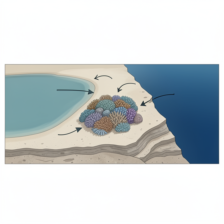
Depositional Environment Zonation
AI-generated conceptual illustration (A shallow carbonate platform cross-section). It explains the idea and does not show study data.
View source evidence ↗Figures & tables
From the original paper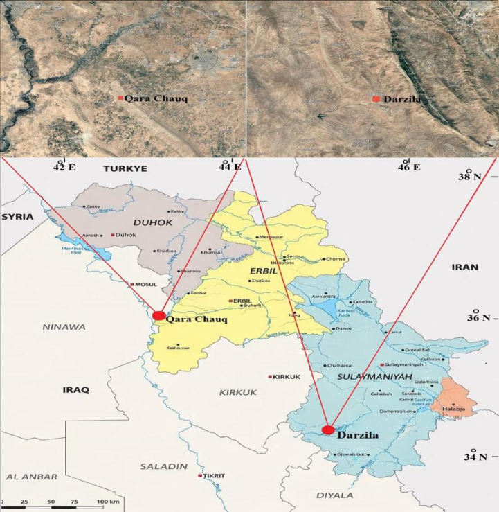 Figure 1
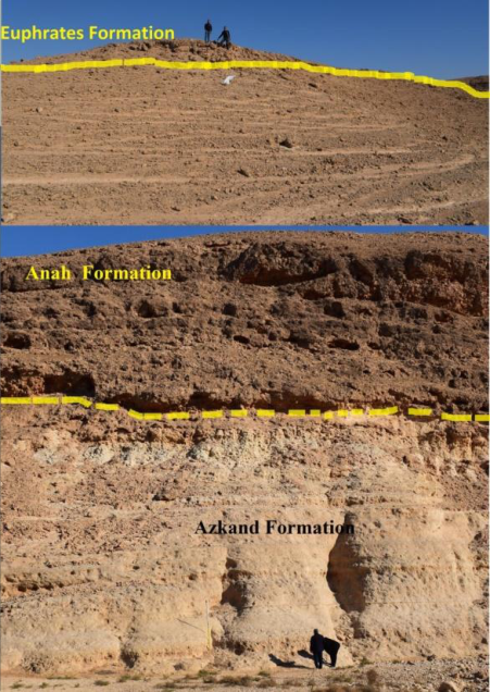 Fig.2
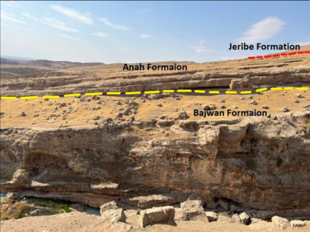 Figure 3
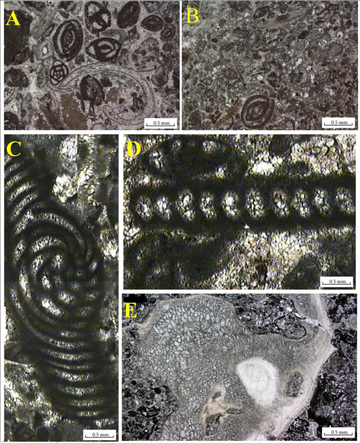 Figure 4
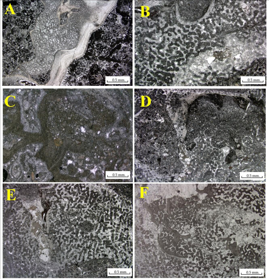 Fig.5
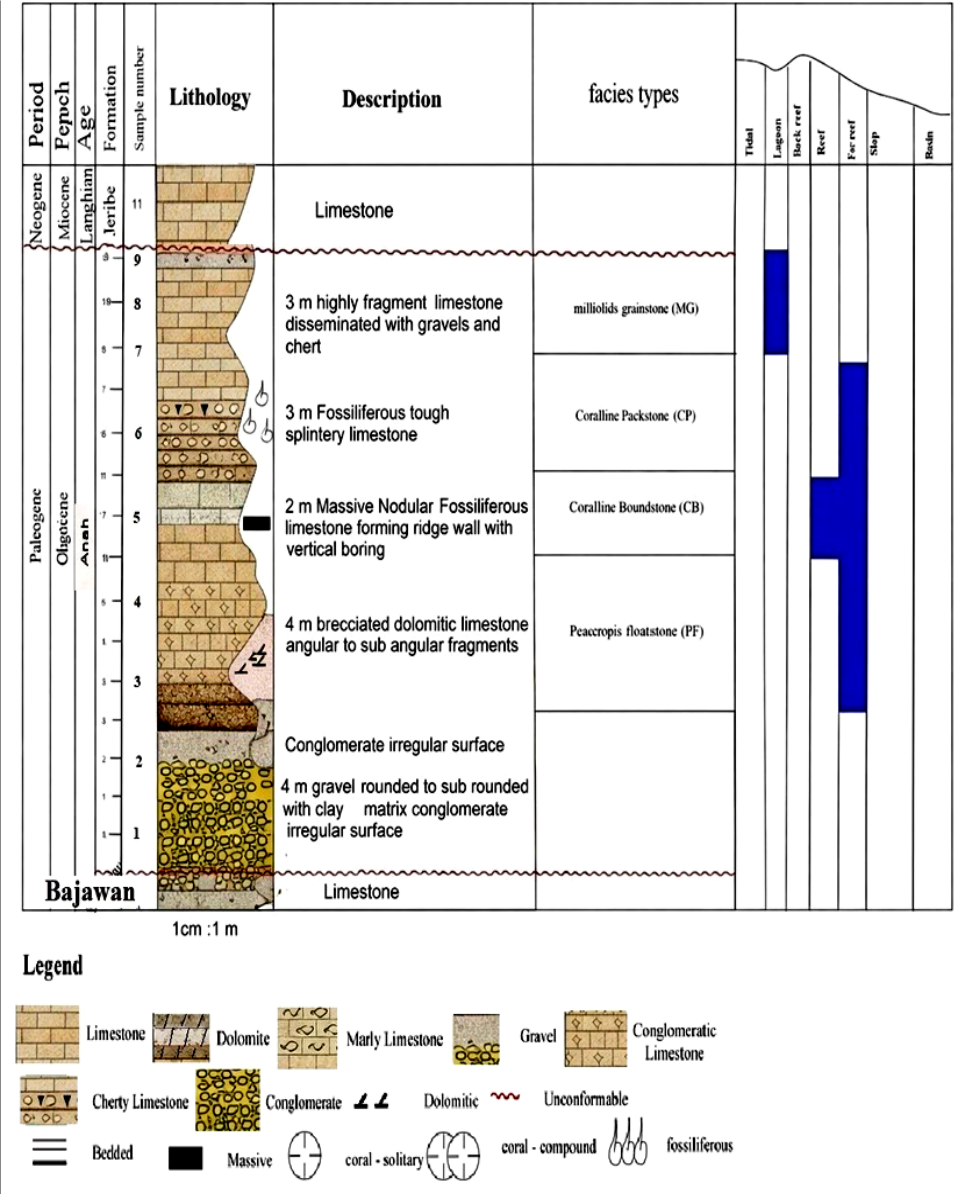 Figure 6
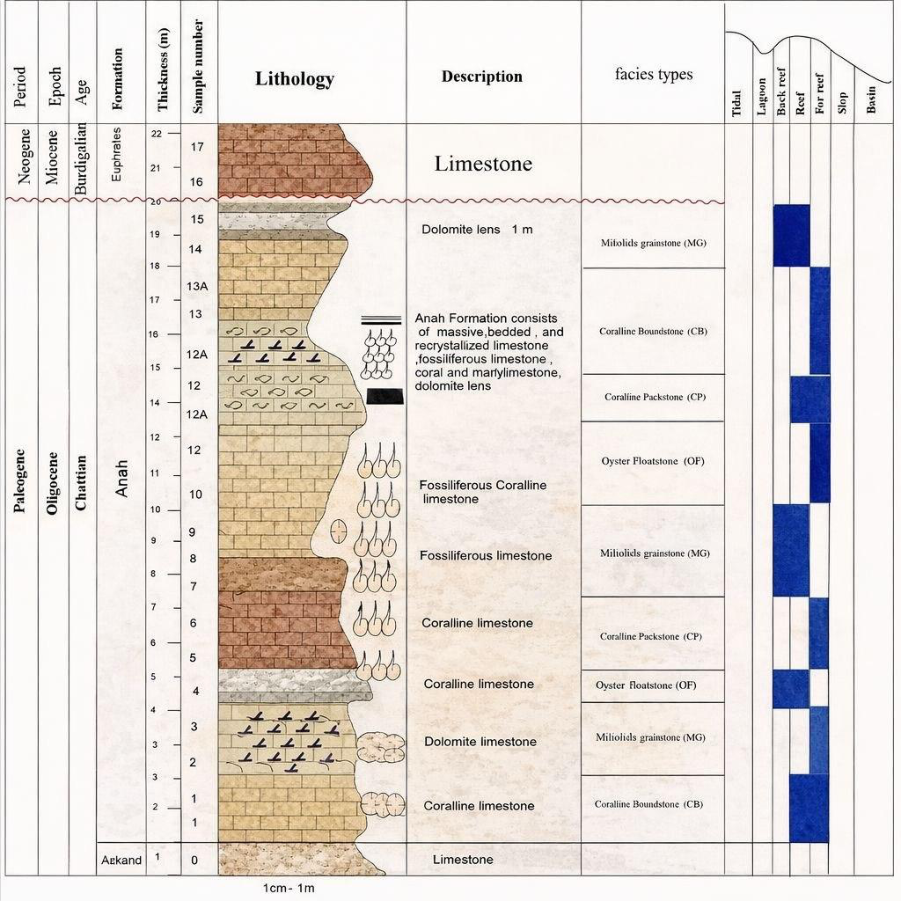 Figure 7
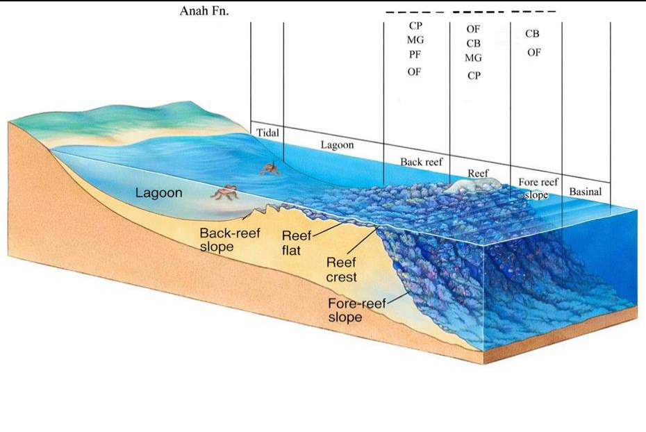 Figure 8
Introduction
The Anah Formation is a crucial carbonate geological formation in Iraq, representing a detailed rock record of depositional events from the Late Oligocene-Early Miocene [1] . Approximately 28 to 23 Million years ago, this formation is named after the Anah region, Situated along the Euphrates river in Anbar governorate, Western Iraq, Which represents the type locality of the formation. The Anah Formation is exposed throughout Iraq, Covering the Western and central areas and northeast in Kurdistan region where it appears in various outcrops as well as in the subsurface of multiple oil fields [2] . This formation is part of the Kirkuk group, which consists successive Oligocene stratigraphic units in Iraq, Namely the Bajwan, Baba, Targil, Azkand and Ibrahim Formations [3] . The significance of studying the Anah Formation is evident across several interconnected scientific dimensions. From a stratigraphic standpoint, this formation constitutes a critical link in establishing the Oligocene-Miocene boundary in Iraq [4] . A boundary that remains the subject of ongoing and nuanced scientific debate among researchers, from an economic standpoint, the Anah Formation in conjunction with the associated Azkand Formation has been firmly established as a significant carbonate reservoir in several Iraqi hydrocarbon bearing structures, including the Khabaz, Melh-Tharthar and Fallujah oil fields [5] . This reservoir significance renders a thorough investigation of its sedimentological and stratigraphic characteristics a matter of considerable applied and practical importance [6] . Notwithstanding the substantial body of scientific research that has been directed toward this formation, numerous aspects of its Sedimentological and stratigraphic character remain incompletely understood and warrant further systematic investigation. These include, in particular, the lateral distribution and variability of depositional facies across the basin, the detailed sequence stratigraphic framework governing its internal architecture, the post-depositional diagenetic processes that have modified the original rock fabric and their consequent implications for reservoir quality, as well as the geological characterization of areas that have hitherto received insufficient scientific attention. It is against this backdrop that the present study is conducted, with the primary objective of shedding new light on this important geological unit and contributing a meaningful scientific addition to the growing body of knowledge pertaining to the geology of Iraq.
Geological Setting
The study areas of Darzila and Qara Chauq are situated in the outer platform of the Western Zagros Fold-Thrust Belt, specifically within the low folded zone [7] . Darzila Section: Darzila city, located in the Sulaimaniyah Governorate, is situated in the Sangaw area at the confluence of the Ashdagh and Khwellen anticlines. Darzila Section is situated in the southwestern dip of the Ashdagh anticline at a latitude of N 35º 14´´ 44´´´, E 45 30 50, about fifteen km southeast of Sangaw city. Qara Chauq Section: Is located in northern Iraq, in the city of Makhmur, Southeast of Mosul governorate, according to the following coordinates: N 35º 40 31, E 43º 39´´ 13´´´ (Fig. 1).
Fig 1:
Tctonic map of Iraq showing the study area [8] Database and Methods
The study was divided into two main stages: Field and Laboratory. During the fieldwork, rock samples were systematically gathered based on stratigraphic variation. Anah Formation thickness was measured, and the upper and lower bounds of the geological formation were established by visiting the assigned study areas. Thirty-two samples in all were collected from Darzila and Qara Chauq sections. Additionally, field photos of the section were taken, and fossil components found inside the rocks were noted. The laboratory work concentrated on the preparation of slides from the field. These slides were then analyzed under a microscope to discern their microfacies correlations. This investigation was used to reconstruct the many palaeoenvironments that existed during deposition.
Additionally, visual representations, depositional models, tables, and photographs were used to chronicle stratigraphic succession and other notable geological features.
Results and Discussion Stratigraphy
The Anah Formation is exposed in Darzila with a thickness of six meters (Fig. 2). It consists of two meters of massive fossiliferous limestone forming a ridge wall with vertical borings, followed by 1.8 meters of limestone that contains a high quantity of fossils, and 2.2 meters of mixed layers of limestone along with pieces of chert and gravels. The top boundary of the Anah Formation is unconformably situated with the Jeribe Formation, whereas the lower boundary is unconformably bounded by the Bajawan Formation due to the presence of conglomerate beds. However, in the Qara Chauq section, the thickness of the Formation is 19 meters (Fig. 3). It consists of layers of bedded limestone, recrystallized limestone, marly limestone, porous limestone, and coralline. These components together represent the stratigraphic column for the Formation in the Qara Chauq section. The upper limit of the Anah Formation is unconformably associated with the Euphrates Formation, whilst the lower boundary is conformably associated with the Azkand Formation.
Microfacies Analysis
Facies analysis aims to elucidate the characteristics of rock, including type, size, grain texture, fossil type and size, in relation to environmental circumstances [9] . The findings of the present study indicate a distinct variance both quantitative and qualitative in skeletal and non-skeletal grains due to alterations in environmental conditions, as evidenced by their sedimentary facies. The classification of [10] , revised by [11] , was employed for its simplicity and comprehensiveness. Microfacies were categorized into microfacies and sub-microfacies, then compared with the standard microfacies and facies zones delineated by [12] and [13] . The Anah Formation's facies were categorized into four microfacies (Grainstone, Floatstone, Boundstone, and Packstone) and two sub-microfacies (Peneroplis Floatstone sub-microfacies and Oyster Floatstone sub-microfacies) as detailed below:
This microfacies is characterized in both sections (Darzila and Qara Chauq) extending around two meters, as well as extending around two to three meters along the Qara Chauq sections (lower, middle, upper). This facies is primarily distinguished by grain-supported textures, with its principal components being imperforate benthic foraminifera, specifically miliolids and peneroplis, together with dolomite, coral, and red algae (Fig. 4.A, B). All remaining components are ancillary and distributed unevenly throughout the facies. The prevalence of many foraminifera indicates that deposition occurred in a reef back-reef habitat characterized by restricted circulation and somewhat hypersaline conditions [14] . Contemporary peneroplis predominantly inhabit shallow-water, low-energy environments [15] . Based on this fauna, the (MG) was deposited in lagoonal environments [16] . This microfacies aligns with (SMF18) of [12] Standard Microfacies and was deposited in the Open Platform (FZ7).
Peneroplis Floatstone Sub-microfacies (PF)
At the lower section of the Anah Formation, roughly two meters were analyzed at the Darzila section, from which this microfacies was characterized. The large foraminifera of the genus Peneroplis represent the most characteristic and prevalent faunal component of this microfacies (Fig. 4.C, D). Peneroplis predominantly inhabits shallow maritime environments, where it typically adheres to near-shore vegetation, as evidenced in the Qatar Arabian Gulf [17] . It was observed that Peneroplis resides in back-reef seaweeds in areas with low sedimentation rates, supporting this ecological hypothesis. The Peneroplis Floatstone submicrofacies is thus deduced to have a back-reef habitat as its depositional context, informed by the biological needs of this significant species. This microfacies aligns with SMF8 of [12] in the conventional microfacies classification and is situated inside Facies Zone FZ5.
Oyster Floatstone Sub-microfacies (OF)
At the middle and lower part of the Qara Chauq section, around one to two meters were analyzed. This microfacies was characterized. Oysters are the predominant and characteristic faunal component of this microfacies, complemented by remnants of Miliolids, Coral, and red algae (Fig. 4.E, Fig. 5.A). The Oyster Floatstone submicrofacies is categorized as a back-reef depositional environment, determined by the faunal assemblage and its ecological significance, as corroborated by [18] . Within the conventional microfacies classification, it is situated in Facies Zone FZ5.
Coralline Boundstone Sub-microfacies (CB)
This microfacies was highlighted in the middle part of the Darzila section, around two meters, and in the Qara Chauq anticline section in the lower part, about two to two and a half meters. This microfacies is predominantly composed of miliolids, red algae, coral, Nummulites fragments, and corals are abundant (Fig. 5.B, C). It is present as a back reef, which is common in open (non-restricted) lagoons and/or barrier reefs that separate the open marine from a restricted lagoon [19] . This microfacies was deposited in a patch reef (middle ramp) environment [20] . This microfacies is conformable with (SMF7) of [12] standard microfacies, deposited in (FZ5).
Coralline Packstone Sub-microfacies (CP)
This microfacies has been marked along the Qara Chauq section (upper, middle, and lower parts) in around two to three meters, and in the upper part of the Darzila section about three and a half meters. The main components are coralline algae, mainly occurring as fragments of nongeniculate specimens, coral, and red algae (Fig. 5.D, E, F).
Coralline red algae are used as a potential tool for paleoecology, paleobathymetry, and paleoenvironment, as well as for the formation of porous and permeable carbonate reservoir rocks for hydrocarbons and reefs rich in hydrocarbons [21] . Geographical ranges are controlled by water temperature, depth ranges, and light intensity [22] . For the abovementioned factors, this facies is widely distributed in tropical to polar normal marine waters, from intertidal depths to the base of the photic zone, at depths of 20-80 m, but could also be present at depths of 80-160 m [23] . Based on this fauna, the packstone sub-microfacies was deposited in a back-reef environment [24] . This microfacies is compatible with (SMF7) of [12] modified by [25] and suggests a back-reef adjacent to the reef body within the proximal side of the mid-ramp environment. association of a micritic matrix with abundant corals and red algae occurs within limestones that reflect a spectrum of shallow carbonate platform lithologies, consistent with a back-reef environment [26] . The occurrence of miliolids, peneroplids, corals, and red algae in sparry calcite cement, particularly within the MG microfacies, is indicative of deposition in reef to back-reef settings [16] . Furthermore, the presence of imperforate foraminifera such as miliolids and peneroplids suggests a shelf lagoon environment [27, 28]. Microfacies MG and CP are interpreted as having been deposited in reef to back-reef environments, whereas CP, PF, OF, and CB accumulated in fore-reef settings. Collectively, the Anah Formation is interpreted to have been deposited across a spectrum of back-reef, reef, and fore-reef environments (Fig. 8).
Conclusions
The Anah Formation exhibits significant thickness variation between the two studied sections, attaining 6 m at Darzila and 19 meters at Qara Chauq. This variation reflects lateral heterogeneity in accommodation space and sediment supply across the depositional basin during the Chattian. It is characterized by five distinct microfacies types: (MG) Miliolids Grainstone, (PF) Peneroplis Floatstone, (OF) Oyster Floatstone, (CB) Coralline Boundstone, and (CP) Coralline Packstone. These microfacies collectively record deposition across a shallow carbonate platform encompassing back-reef, reef, and fore-reef environments.
Correlation with the standard microfacies (SMF) scheme of Wilson [12] and the facies zone (FZ) of Flügel [13, 23]
Figures and tables from the paper
References
27 in the original paper- Al-Twaijri FS. Sequence Stratigraphic Analysis of the Oligocene Succession in Western Iraq. M.Sc. Thesis, University of Baghdad. 2000:166 pp.
- Bellen RC Van. The stratigraphy of the main limestone of Kirkuk, Bai Hassan, and Qarah Chauq Dagh structures in northern Iraq. J Inst Petrol. 1956;42:233263.
- Behnam HA. Stratigraphy and Palaeontology of the Khanaqin Area, NE Iraq. GEOSURV, Internal Report No. 903. Iraqi Bull Geol Min. 1979;15(2).
- Al-Banna NY. Oligocene/Miocene boundary in northern Iraq. GeoArabia. 2008;13(2):187-218. Gulf PetroLink, Bahrain.
- Abood MS, Al-Zaidy A. Depositional environment and stratigraphic sequence of the Oligocene succession in Fallujah and Melh-Tharthar oilfields. Iraqi Geol J. 2024;57(2F):168-183.
- Buday T. The Regional Geology of Iraq, Vol. 1: Stratigraphy and Palaeogeography. In: Kassab II, Jassim SZ, editors. GEOSURV, Baghdad. 1980:445 pp.
- Fouad SF. Western Zagros Fold-Thrust Belt, Part II: The High Folded Zone. Iraqi Bull Geol Min. 2015;Special Issue No. 6:53-71.
- Boggs SJ. Principles of Sedimentology and Stratigraphy. 4th ed. Pearson Prentice-Hall; 2006:662 pp.
- Dunham RJ. Classification of carbonate rocks according to depositional texture. In: Ham WE, editor. Classification of Carbonate Rocks. AAPG Memoir 1. 1962:108-121.
- Embry A, Klovan JE. A Late Devonian reef tract on northeastern Banks Island, N.W.T. Bull Can Petrol Geol. 1971;19:730-781.
- Wilson JL. Carbonate Facies in Geologic History. Springer-Verlag, Berlin; 1975:471 pp.
- Flügel E. Microfacies of Limestone. Translated by K. Christenson. Springer-Verlag, Berlin; 1982:633 pp.
- Romero J, Caus E, Rosell JA. A model for the palaeoenvironmental distribution of larger foraminifera based on late middle Eocene deposits on the margin of the south Pyrenean basin (NE Spain). Palaeogeogr Palaeoclimatol Palaeoecol. 2002;179:43-56.
- Hottinger L. Shallow benthic foraminiferal assemblages as signals for depth of their deposition and their limitations. Bull Soc Géol Fr. 1997;168:491-505.
- Vecchio E, Hottinger L. Agglutinated conical foraminifera from the lower Middle Eocene of the Trentinara Formation (southern Italy). Facies. 2007;53:509-533.
- Murray JW. Living foraminifera in the northern Florida Keys. Am Assoc Petrol Geol Bull. 1968;41(4):727-741.
- Kirby M, Jackson J. Extinction of a fast-growing oyster and changing ocean circulation in Pliocene tropical America. Geology. 2004;32:1025-1028.
- Tucker ME, Wright VP, Dickson J. Carbonate Sedimentology. Wiley-Blackwell; 1990.
- Stanley GD. The evolution of modern corals and their early history. Earth-Sci Rev. 2003;60:195-225.
- Kundal P. Generic distinguishing characteristics and stratigraphic ranges of fossil corallines. J Geol Soc India. 2011;78:571-586.
- Johansen HW. Coralline Algae, a First Synthesis. CRC Press, Boca Raton; 1981:239 pp.
- Flügel E. Microfacies of Carbonate Rocks: Analysis, Interpretation and Application. Springer-Verlag, Berlin; 2004:984 pp.
- Sharaf E, BouDagher-Fadel MK, Simo J, Carroll AR. A revision of the biostratigraphy and strontium isotope dating of Oligocene-Miocene outcrops in East Java, Indonesia. Berita Sedimentol. 2014;30:44-81.
- Schlager W. Carbonate Sedimentology and Sequence Stratigraphy. SEPM Concepts in Sedimentology and Palaeontology, Vol. 8. Amsterdam; 2005:200 pp.
- Li J, Hu X, Garzanti E, BouDagher-Fadel M. Shallowwater carbonate responses to the Palaeocene-Eocene thermal maximum in the Tethyan Himalaya (southern Tibet): tectonic and climatic implications. Palaeogeogr Palaeoclimatol Palaeoecol. 2016;466:153-165.
- Al-Ghreri MF, Al-Jibouri AS, Al-Heety SO. Facies characteristics, depositional environments and sequence stratigraphy of the Euphrates Formation in Hadetha Area, western Iraq. Int J Sci Res (IJSR). 2013;4(4):181189.
- Yazdani R. Biostratigraphy and facies distribution of the Asmari Formation in Aghajari Well 66, Zagros Basin, SW Iran. Int Res J Geol Mining (IRJGM). 2014;4(4):101-115.