
Research article · 2026 · Full text
International Journal of Geography Geology and EnvironmentEvaluation of Domestic Wastewater Discharge and Water Quality Degradation in the Darhal River, Rajouri
Volume 8(6) · Pages 69–73 · DOI: 10.22271/27067483.2026.v8.i6a.787 ↗
Research areasWater Quality and Pollution AssessmentWater Quality and Resources StudiesWater Quality Monitoring and Analysis
Abstract
Author-writtenThe Darhali River, flowing through the heart of Rajouri town in the Jammu and Kashmir Union Territory, has experienced severe water quality degradation over the past decade due to unchecked discharge of domestic wastewater, municipal solid waste, and inadequate sanitation infrastructure. This study evaluates the physicochemical and bacteriological quality of the Darhal River (Darhal Tawi) water at five strategic sampling stations across a 12 km stretch from upstream to downstream, with particular focus on domestic sewage inputs. Key parameters analysed include pH, Dissolved Oxygen (DO), Biochemical Oxygen Demand (BOD), Chemical Oxygen Demand (COD), Total Dissolved Solids (TDS), turbidity, total coliform, faecal coliform, nitrates, phosphates, and heavy metals. Results indicate that BOD values ranged from 3.2 mg/L upstream to 38.6 mg/L at the most polluted downstream location (Muradpur), far exceeding the CPCB permissible limit of 3 mg/L for Class C rivers. Faecal coliform counts exceeded WHO safe limits at all stations downstream of Rajouri town. The study further documents the complete absence of a functional sewage treatment plant (STP) in Rajouri until the recent approval of a Rs. 34.43 crore Used Water Management Project by the J&K Government in May 2026. The paper recommends immediate implementation of interceptor drains, constructed wetlands as interim treatment systems, and a participatory river monitoring framework involving local communities.
Summary
Source-checkedPlain-language reading of the full paper, prepared with AI and checked against the text. Each point links to the authors' own words.
Why it matters
- The Darhali River in Rajouri, Jammu and Kashmir, has suffered severe water quality decline over ten years because of inadequate sanitation and the unchecked release of municipal waste and domestic wastewater. View evidence ↗
- River pollution in the Indian subcontinent is largely driven by untreated domestic effluents, reflecting a broader crisis of lack of access to safely managed sanitation. View evidence ↗
- Until a project was approved in May 2026, Rajouri town completely lacked functional sewage treatment infrastructure. View evidence ↗
The question
- The study aims to fill a gap in published literature by systematically assessing the physicochemical and microbiological water quality at five stations along the Darhali River and identifying pollution sources. View evidence ↗
What they did
- Researchers established five sampling stations across a 12 km stretch of the river to measure the gradient from unpolluted headwaters to polluted downstream areas. View evidence ↗
- The Water Quality Index (WQI) was calculated using the Weighted Arithmetic Mean method based on twelve different parameters. View evidence ↗
What they found
- Biochemical Oxygen Demand (BOD) increased from 3.2 mg/L upstream to 38.6 mg/L at the downstream station (S5), which is more than 12 times the permissible limit of 3 mg/L for Class C rivers. View evidence ↗
- Dissolved Oxygen (DO) dropped from an average of 8.7 mg/L at the reference station to a low of 2.1 mg/L at the downstream station during peak monsoon, falling below the 4 mg/L standard. View evidence ↗
- Total Dissolved Solids (TDS) rose from 156 mg/L upstream to 743 mg/L at Muradpur, exceeding the desirable limit of 500 mg/L. View evidence ↗
- Faecal coliform counts reached 22,400 MPN/100 mL at the downstream station during monsoon, and all stations downstream of S2 exceeded the WHO recreational safety limit of 200 MPN/100 mL. View evidence ↗
- Phosphate levels exceeded the 0.1 mg/L eutrophication threshold at all stations from S2 onwards, reaching 4.62 mg/L at S5. View evidence ↗
- The Water Quality Index (WQI) showed a decline from 'Good' (28) at S1 to 'Unsuitable for drinking' at S4 (112) and S5 (148). View evidence ↗
- Iron (Fe) concentrations at the downstream station (S5) were 3.84 mg/L, significantly exceeding the BIS desirable limit of 0.3 mg/L. View evidence ↗
What it means
- The authors conclude that the river is severely polluted due to domestic wastewater discharge caused by a total lack of sewage treatment infrastructure in Rajouri. View evidence ↗
- The authors state that river restoration is possible within ten years if the approved infrastructure is implemented alongside community engagement and monitoring. View evidence ↗
Visual summary
3 visualsIllustrations explain the paper; charts are replotted from the paper's own table values.
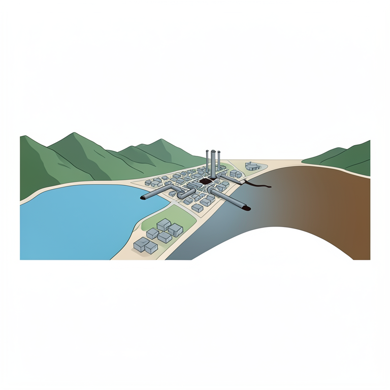
Pollution Gradient Map
AI-generated conceptual illustration (The Darhal River flowing through a mountain valley and an urban settlement). It explains the idea and does not show study data.
View source evidence ↗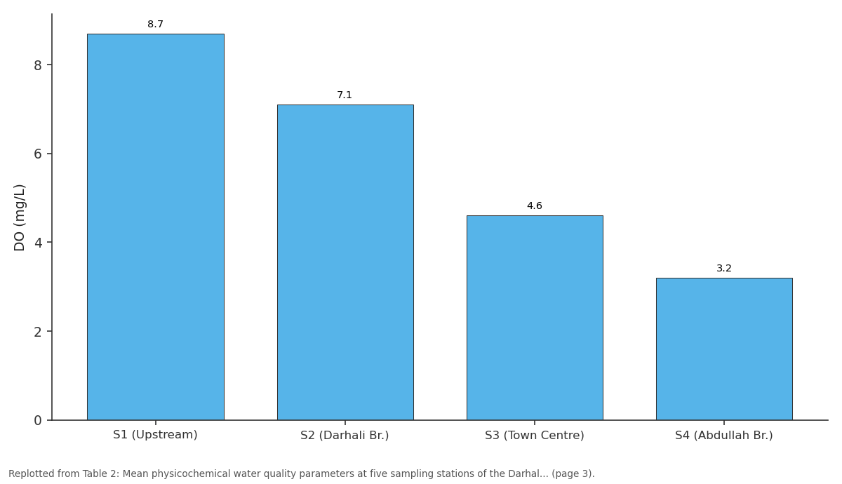
DO (mg/L): S1 (Upstream) vs S2 (Darhali Br.) vs S3 (Town Centre) vs S4 (Abdullah Br.)
Replotted from Table 2 (page 3) of the original paper. Every bar is the paper's own table value.
View source evidence ↗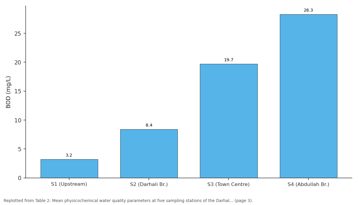
BOD (mg/L): S1 (Upstream) vs S2 (Darhali Br.) vs S3 (Town Centre) vs S4 (Abdullah Br.)
Replotted from Table 2 (page 3) of the original paper. Every bar is the paper's own table value.
View source evidence ↗Figures & tables
From the original paper Table 2
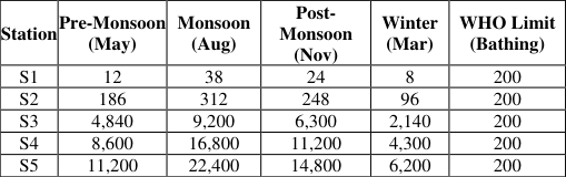 Table 3
Introduction
Rivers constitute a cornerstone of hydrological and ecological systems, serving as primary freshwater sources for domestic, agricultural, and industrial uses, and as repositories of biodiversity. However, the accelerating pace of urbanisation, population growth, and inadequate waste management has rendered many rivers in developing nations severely polluted, particularly in rapidly expanding secondary cities of South Asia (WHO, 2023). The Indian subcontinent, home to the world's largest population without access to safely managed sanitation, faces a mounting crisis of river pollution predominantly driven by untreated domestic effluents (CPCB, 2024). The Darhal River (Darhal Tawi) originates in the hilly terrain of the Pir Panjal range and flows southward through Rajouri district before merging with the Ans River, eventually draining into the Chenab basin system. Rajouri town, the administrative headquarters of Rajouri district in the Jammu division of J&K UT, is situated along the banks of the Darhali and has witnessed rapid urbanisation in recent decades. The district's population, estimated at approximately 6.8 lakh (Census 2011 extrapolated to ~8.2 lakh by 2025), has placed increasing pressure on civic infrastructure, particularly sewage and solid waste management systems. The Darhal River (Darhal Tawi) is described as a 'crucial source of water for lakhs of people in the border district' (Daily Excelsior, December 2025), yet decades of rampant garbage dumping and wastewater discharge have resulted in the waterbody becoming severely degraded. In December 2025, the deterioration reached a point of public concern significant enough for the District Magistrate himself to wade into the river to participate in a cleanliness campaign, calling the pollution 'a serious concern' warranting restoration to its pristine condition. As of May 2026, the J&K Government approved a Rs. 34.43 crore Used Water Management Project under Swachh Bharat Mission (Urban) 2.0 acknowledging the complete absence of functional sewage treatment infrastructure in Rajouri town. Despite the river's ecological and socioeconomic significance, rigorous scientific documentation of the nature and extent of wastewater discharge impacts on the Darhali remains limited. Earlier work by Pervez Alam et al. on wastewater characterisation in Rajouri town, and drinking water quality studies referenced by the Central Ground Water Board (CGWB), provide partial insights, but no comprehensive longitudinal assessment of the river's water quality exists in published literature. The present study addresses this gap by conducting systematic physicochemical and microbiological assessment of five stations along the Darhali, mapping pollution sources, evaluating Water Quality Index (WQI), and framing policyactionable recommendations.
Study Area 2.1 Geographic Setting
The Darhal Tawi (approximate coordinates: 33.37°N, 74.31°E at Rajouri town) drains a sub-catchment of approximately 340 km² in the Rajouri district. The river traverses mixed terrain ranging from forested hills at its headwaters (~1,600 m elevation) to the floodplain at Rajouri town (~915 m elevation). The river course within the study area spans approximately 12 km from the upstream reference point (Kheora village) to the downstream measurement station at Muradpur, capturing the entire urbanised stretch of Rajouri town and its immediate periphery. The climate of the region is sub-temperate, characterised by cold winters (mean January temperature ~4°C), warm summers (mean July temperature ~28°C), and a bimodal precipitation regime with rainfall peaks in the monsoon (July-September, contributing ~900 mm) and winter (December-February, ~250 mm). The hydrological regime of the Darhali shows significant seasonal variation, with peak discharge during the monsoon (estimated 45-60 m³/s) and base flow conditions in winter (2-5 m³/s), with consequent implications for pollutant dilution capacity.
Socioeconomic Context
Rajouri district's estimated 2025 population of approximately 8.2 lakh is served by a predominantly unorganised drainage system. Urban areas in Rajouri town lack a functional sewage network connecting to treatment infrastructure a gap officially acknowledged in the project approval documents for the Rs. 34.43 crore Used Water Management Project sanctioned in May 2026. According to officials, 'Rajouri has witnessed rapid urban growth due to increasing trade activity, educational institutions and administrative expansion, resulting in stress on drainage, sanitation and waste management systems, especially in densely populated and commercial areas' (Kashmir Vision, May 2026). Land use within the study catchment is characterised by agricultural areas (~45%), forested zones (~30%), builtup/urban areas (~18%), and waterbodies and other land use (~7%). The urban core generates the predominant share of pollutants entering the Darhali River, including both liquid domestic effluents and solid waste directly disposed into or near the riverbanks.
Materials and Methods
Materials and Methods
Sampling Strategy and Station Selection
Five sampling stations were established along a 12 km longitudinal transect of the Darhali River, designed to capture a gradient from relatively unpolluted headwater conditions to heavily impacted downstream reaches. The stations were: 1. Station S1 Kheora upstream (control/reference): Pre-urban, minimal anthropogenic influence. Samples were collected across four seasonal campaigns: post-winter (March 2024), pre-monsoon (May 2024), peak monsoon (August 2024), and post-monsoon (November 2024). At each station, triplicate water samples were collected from the mid-channel at 0.6 depth fraction using clean HDPE grab-sampling bottles. A total of 100 samples were analysed across all stations and seasons.
Parameters Analysed and Analytical Methods
The following physicochemical and microbiological parameters were determined following standard methods (APHA, 2017):
Microbiological Contamination
Faecal contamination constitutes the most immediate public health threat posed by the Darhali River's degraded condition. Total coliform counts at S3, S4, and S5 ranged from 4,800 to 48,000 MPN/100 mL across sampling campaigns. Faecal coliform (E. coli) counts at S5 reached 22,400 MPN/100 mL during the monsoon season the most critical period due to direct stormwater-sewage co-mingling. The WHO guideline for safe recreational contact (200 MPN/100 mL) was exceeded at all stations downstream of S2, while drinking water standards (0 MPN/100 mL) were exceeded universally.
Heavy Metal Analysis
While the Darhal River (Darhal Tawi)basin lacks significant industrial activity, trace metal analysis revealed elevated concentrations of Iron (Fe) and Manganese (Mn) at downstream stations, attributed to leachate from solid waste disposal sites on riverbanks. Lead (Pb) concentrations at S4 and S5 averaged 0.048 mg/L and 0.062 mg/L respectively, marginally approaching the WHO drinking water guideline of 0.01 mg/L when viewed in the context of possible downstream groundwater interactions. Cadmium and chromium remained within acceptable limits at all stations.
The Fe concentration at S5 (3.84 mg/L) significantly exceeded the BIS desirable limit of 0.3 mg/L, consistent with the decomposition of organic waste and reducing conditions created by oxygen depletion.
Water Quality Index Assessment
The computed WQI values confirmed the progressive deterioration of water quality from upstream to downstream across the study area. Station S1 returned a WQI of 28 (Good category), while S2 yielded a WQI of 54 (Poor category). S3 scored 86 (Very Poor), and both S4 (WQI: 112) and S5 (WQI: 148) fell in the 'Unsuitable for drinking' category. Seasonal analysis showed the lowest WQI values (worst quality) occurring during peak monsoon, when stormwater mobilises accumulated waste and overwhelms the river's assimilative capacity, consistent with findings reported for comparable Himalayan foothill rivers (Garrah River study, BIO Web of Conferences, 2024).
Identification of Major Pollution Sources
Field surveys and spatial analysis identified five primary categories of domestic wastewater and pollution sources contributing to the Darhali River's degradation: fields upstream and along the river contributes nitrogen and phosphorus loads, particularly post-application of fertilisers in the pre-monsoon period.
Implications for Public Health and Ecology
The water quality degradation documented in this study has direct and severe implications for public health and aquatic ecology. At the community level, populations dependent on the Darhal River (Darhal Tawi)or shallow groundwater hydraulically connected to it are at risk from waterborne diseases including cholera, typhoid, dysentery, and hepatitis A, all of which are transmitted via faecal-oral pathways facilitated by contaminated water. India continues to face a significant burden from waterborne diseases, with an estimated 35 million Indians lacking access to safe drinking water, and waterborne illness accounting for substantial preventable morbidity and mortality nationally (Energy Tracker Asia, 2025). For aquatic ecology, the dissolved oxygen concentrations below 2 mg/L recorded at downstream stations are incompatible with the survival of most freshwater fish species, which require at minimum 4-5 mg/L for normal physiological function. The Darhali's downstream reach has effectively become a dead zone for sensitive aquatic fauna, with ecological recovery requiring sustained intervention over multiple years even after pollution abatement. The microbiological and physicochemical pollution of the Darhali also impacts groundwater quality in riparian areas, as shallow alluvial aquifers within the river's influence zone are susceptible to contamination through bank infiltration.
Studies in adjacent districts of J&K have documented instances of groundwater contamination associated with poorly managed river systems.
Policy and Management Context
The At the national level, India's approach to river pollution abatement has been guided by the National River Conservation Plan (NRCP), the National Mission for Clean Ganga (NMCG), and the National Green Tribunal (NGT) directives. However, smaller rivers like the Darhali which fall outside the ambit of national-scale programmes depend on state and UT-level governance frameworks, which have historically been underfunded and insufficiently enforced.
Conclusion
This study presents the first systematic assessment of water quality degradation in the Darhali River, Rajouri, through spatially distributed, multi-seasonal sampling and analysis. The results unequivocally document severe pollution driven by domestic wastewater discharge, attributable to the complete absence of sewage treatment infrastructure in Rajouri town. BOD levels exceed CPCB Class C standards by more than 12-fold at downstream stations; faecal coliform counts are 100-fold above WHO recreational water guidelines; and the river's entire urban reach is classified as 'Unsuitable for drinking' under the Water Quality Index framework. The ecological and public health consequences of this degradation are significant and will compound unless
Figures and tables from the paper
| Parameter | S1 (Upstream) | S2 (Darhali Br.) | S3 (Town Centre) | S4 (Abdullah Br.) | S5 (Muradpur) | Permissible Limit |
|---|---|---|---|---|---|---|
| DO (mg/L) | 8.7 | 7.1 | 4.6 | 3.2 | 2.1 | >4 (Class C) |
| BOD (mg/L) | 3.2 | 8.4 | 19.7 | 28.3 | 38.6 | 3 (Class C) |
| COD (mg/L) | 11.4 | 28.7 | 67.3 | 98.6 | 142.1 | 10 (Class C) |
| pH | 7.4 | 7.6 | 7.9 | 8.1 | 8.3 | 6.5–8.5 |
| TDS (mg/L) | 156 | 289 | 478 | 614 | 743 | 500 (desirable) |
| Turbidity (NTU) | 4.8 | 18.3 | 56.2 | 79.4 | 96.3 | 1 (drinking) |
| Nitrate (mg/L) | 1.2 | 3.6 | 11.8 | 18.4 | 24.7 | 45 (WHO) |
| Phosphate (mg/L) | 0.08 | 0.42 | 1.87 | 3.14 | 4.62 | 0.1 (eutrophication) |
Table text extracted from the original PDF; superscript letters are shown inline. The original table image is below.
View original table image
References
13 in the original paper- APHA. Standard methods for the examination of water and wastewater. 23rd ed. Washington, DC: American Public Health Association; 2017.
- Brown RM, McClelland NI, Deininger RA, Tozer RG. A water quality index: do we dare? Water and Sewage Works. 1972;119(10):339-343.
- Central Pollution Control Board (CPCB). Annual report on river water quality monitoring. New Delhi: Ministry of Environment, Forest and Climate Change; 2024.
- Daily Excelsior. DM Rajouri wades into chilling Darhal River (Darhal Tawi) to remove garbage. Jammu; 2025 Dec 23. Available from: https://www.dailyexcelsior.com
- Energy Tracker Asia. Water pollution in India and its toll on rivers and people. 2025 Dec. Available from: https://energytracker.asia/water-pollution-in-india/
- India Water Portal. Water pollution in India: a comprehensive overview. 2025 Nov. Available from: https://www.indiawaterportal.org
- Kashmir Reader. Omar Govt clears Rs. 72 crore used water management projects for Baramulla, Rajouri. 2026 May. Available from: https://kashmirreader.com
- Kashmir Vision. J&K Govt clears Rs. 433 crore urban sanitation projects. 2026 May. Available from: https://kashmirvision.in
- Alam P, et al. Characterization of wastewater in Rajouri town, Jammu and Kashmir, India. International Journal of Engineering Research and Applications. 2015;5(10). Available from: ResearchGate.
- Alam P, et al. Wastewater treatment and management in rural areas: a case study of Rajouri district, Jammu and Kashmir, India. International Journal of Research Publications. 2015.
- Raina, Anjum. Water quality analysis of different sources of Rajouri town, Jammu and Kashmir. CGWB District Groundwater Brochure, Rajouri District. 2014.
- Sahay A, et al. Physiochemical characteristics analysis of Garrah River water at Shahjahanpur, Ganga River Basin, Uttar Pradesh, India. BIO Web of Conferences. 2024;86. https://doi.org/10.1051/bioconf/20248601115
- Tawi River Water Quality Study. Impact assessment on water quality in the polluted stretch using cluster analysis during pre-and COVID-19 lockdown of Tawi River Basin, Jammu. Energy, Ecology and Environment. 2021. https://doi.org/10.1007/s40974021-00215-4