
Research article · 2026 · Full text
International Journal of Geography Geology and EnvironmentAnchoring the Indo-pacific: The strategic imperatives behind India’s Great Nicobar development
Volume 8(6) · Pages 23–29 · DOI: 10.22271/27067483.2026.v8.i6a.781 ↗
Research areasMaritime Security and HistoryIsland Studies and Pacific AffairsBelt and Road Initiative
Abstract
Author-writtenThe Holistic Development of Great Nicobar Island, authorized by NITI Aayog through an initial investment of ₹72,000 crore and subsequently increased to around ₹81,000 crore by 2025, represents the biggest single infrastructure project India has ever committed to a border region. This essay seeks to argue that the project should be understood not as an infrastructure program but rather as India’s greatest gamble in terms of geography in the Indo-Pacific that involves the conscious transformation of an island frontier into an ongoing forward operating base towards the east of the Strait of Malacca. The core argument proposed herein is that the geostrategic rationale behind it is well founded, the strategic objective is legitimate, but its success depends on overcoming three outstanding issues that are: i) ecological irreversibility in a tectonically active Zone V environment, ii) the population security risks for the indigenous Shompen and Nicobarese communities, and iii) an unresolved commercial proposition vis-a-vis dominant transshipment ports in Colombo and Singapore. Each of these can corrode the rules-based legitimacy India is trying to claim as the basis of its Indo-Pacific leadership. The paper proceeds through six analytical moves: a material audit of the project, a geographical reading of the Six Degree Channel, an assessment of the China factor, a comparative typology of forward island bases, a scenario-based projection of strategic outcomes, and a structured engagement with counter arguments. The conclusion is qualified support, with four policy recommendations that decouple the strategic-military case from the maximalist commercial case.
Summary
Source-checkedPlain-language reading of the full paper, prepared with AI and checked against the text. Each point links to the authors' own words.
Why it matters
- India's economic future, energy security, and strategic competition with China are tied to the eastern approach of the Indian Ocean, where the Andaman and Nicobar Islands extend India's reach by about 1,200 kilometres toward the Strait of Malacca. View evidence ↗
- The Strait of Malacca is a critical global chokepoint; in the first half of 2025, it handled approximately 23.2 million barrels of oil per day, which is 29% of all international sea-borne oil shipments. View evidence ↗
- The Holistic Development of Great Nicobar Island is India's largest border region infrastructure project, with investment increasing from an initial ₹72,000 crore to approximately ₹81,000 crore by 2025. View evidence ↗
The question
- The paper aims to argue that the Great Nicobar project is not merely an infrastructure program, but a strategic geographical gamble to transform an island frontier into a forward operating base near the Strait of Malacca. View evidence ↗
What they did
- The authors analyze the project using six methods: a material audit, a geographical study of the Six Degree Channel, an assessment of China's role, a comparison of forward island bases, scenario projections, and an evaluation of counter-arguments. View evidence ↗
- The project's material scope includes an International Container Transshipment Port (ICTP) at Galathea Bay, a 3,300-metre runway airport, a 450 MVA gas and solar power plant, and a township covering 16,610 hectares. View evidence ↗
What they found
- The region is strategically vital as over 94,000 commercial vessels pass through annually, accounting for an estimated 40% of international trade between Japan, South Korea, and China. View evidence ↗
- The project's environmental impact includes the diversion of 130 square kilometers of forest, the felling of 852,245 trees, and the reclamation of 300 hectares of land from the sea. View evidence ↗
- The development poses a risk to the Shompen, a Particularly Vulnerable Tribal Group consisting of an estimated 200 to 400 people. View evidence ↗
- The area is seismically vulnerable, as evidenced by the December 26, 2004, Sumatra-Andaman earthquake, which caused Indira Point to recede by approximately 4.25 metres. View evidence ↗
What it means
- The authors recommend decoupling the military strategic goals from the maximalist commercial port goals and limiting the scope of Phase One. View evidence ↗
- The authors propose codifying a 'do not contact' policy for the Shompen people through the Forest Rights Act and establishing an independent oversight panel of tribal rights experts. View evidence ↗
- The authors note that government assertions regarding the viability of feeder networks for the port have not been independently validated. View evidence ↗
Visual summary
1 visualsIllustrations explain the paper; they do not show study data.
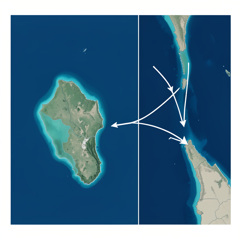
Strategic Proximity Map
AI-generated conceptual illustration (The Great Nicobar Island and the surrounding maritime geography of the Six Degree Channel and the Strait of Malacca). It explains the idea and does not show study data.
View source evidence ↗Figures & tables
From the original paper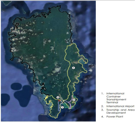 Figure 1
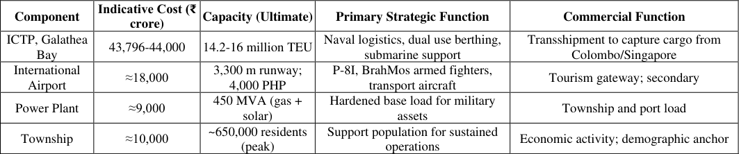 Table 1
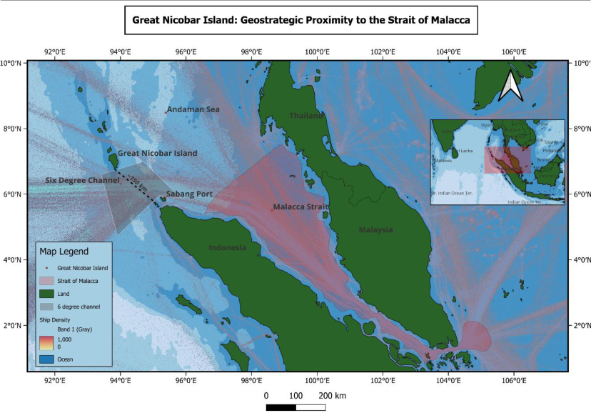 Figure 2
 Table 2
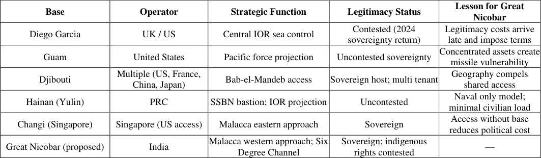 Table 3
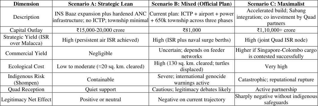 Table 4
Introduction
India occupies a unique position in current Indo-Pacific debates. Its mainland is continental, its political identity is land-bordered, and its civilian foreign-policy idiom is reflected by non-alignment. Whereas its economic future, its energy security, and its strategic competition with China all run through the sea and specifically through the eastern approach to the Indian Ocean, where the Andaman and Nicobar Islands extend the country's territorial reach by roughly 1,200 kilometres towards the Strait of Malacca. The Holistic Development of Great Nicobar Island is the first serious attempt in independent India's history to capitalise on that geography. The project was approved in principle by NITI Aayog in 2021 and received environmental clearance in November 2022. It comprises four components: an International Container Transshipment Port (ICTP) at Galathea Bay, a greenfield international airport with a 3,300metre runway, a 450 MVA gas and solar power plant, and a township spread across 16,610 hectares. In September 2024 the port was notified as India's thirteenth Major Port. In February 2026 the National Green Tribunal upheld its environmental clearances, citing strategic importance. In mid-2026, the Detailed Project Report will be completed, and tendering of Phase I will commence with an objective to launch first cargo by 2028. Whether or not India needs an Indo-Pacific strategy is not being debated in this paper; that is settled by official policy documents going back to the SAGAR (Security and Growth for All in the Region) doctrine of 2015 and the new MAHASAGAR (Maritime Heads for Active Security and Growth for All in the Region) of 2025. Rather, the debate addressed here is what the geopolitical geography of Great Nicobar implies, and under what circumstances.
The answer, articulated below, is that while geography gives India a prize it did not previously enjoy, this requires conditions not yet answered by the project itself. This paper will consider different aspects moving through sections. In Literature Review Section, relevant geopolitical theory will be reviewed, focusing on chokepoints and their geographies, and the inverse nature of anti-access logic. In the Project Dynamics Section, the project will be analyzed as material geography. In The Geographical Argument Section, the core thesis regarding the strategic importance of the Six Degree Channel, Malacca chokepoint will be stated and argued. The China Factor Section will consider China's role. In Comparative Typology Section, Great Nicobar will be evaluated against other examples of forward island bases. The Section Strategic Outcomes will project strategic consequences under three scenarios. Counter Arguments Section considers counter cases. The last section i.e. the conclusion provide the policy recommendation on what more progressive can be done.
Conceptual Framework through Literature Review
The Great Nicobar Project sits at the intersection of three durable traditions in geopolitical theory. Alfred Thayer Mahan's doctrine of command of the seas, articulated in The Influence of Sea Power upon History (1890) [12] , underwrites the basic logic of investing scarce capital in a remote oceanic platform: maritime power is concentrated at chokepoints, and chokepoints are decisive. Halford Mackinder's heartland thesis, presented in "The Geographical Pivot of History" (1904) [11] , privileges Eurasian land power and would, on its own terms, treat the project as marginal. Nicholas Spykman's rimland rejoinder in America's Strategy in World Politics (1942) is more relevant, locating the decisive contest along the maritime margin of Eurasia, precisely where Great Nicobar lies (Mahan, The Influence of Sea Power upon History, 1890; Mackinder, "The Geographical Pivot of History," 1904; Spykman, America's Strategy in World Politics, 1942) [12,11] . K. M. Panikkar grafted Mahan onto Indian historical geography in India and the Indian Ocean (1945) [17] with the formulation that whoever controls the Indian Ocean has India at its mercy. Modern Indian strategists including C. Raja Mohan, Brahma Chellaney, Abhijit Singh, and Pradeep Chauhan have updated this formulation for the Indo-Pacific era. Western analysts including Geoffrey Till, James Holmes, Toshi Yoshihara, and Robert Kaplan have similarly interpreted Indian strategic moves through the lens of contested sea power. The convergence between these literatures is unusual and significant because the same geographical fact reads as strategically central from both Indian and Western analytical standpoints (Panikkar, India and the Indian Ocean, 1945; Mohan, Samudra Manthan, 2012; Till, Seapower, 2018) [17] . Another relatively recent concept imported from elsewhere is A2/AD (Anti-Access/Area Denial), initially conceived for China along the First Island Chain. To understand the Great Nicobar Project is to invert the concept -that is, to see India as building an Indian A2/AD bubble preventing any hostile transit through the Six Degree Channel in a Sino Indian crisis. The inversion is precise: A2/AD need not be a bluewater navy, but only geography, sensors, and long range fires. Geography is supplied by Great Nicobar itself. The institutional framework is the Andaman and Nicobar Command. The sensor architecture will come with the Indo-Pacific Maritime Domain Awareness (IPMDA) initiative inaugurated by the 2022 Quad meeting in Tokyo. Long range fire capacity includes BrahMos launchers, P-8I maritime patrol aircraft, and MQ-9B Sea Guardian UAVs under procurement. Two analytical insights follow from the foregoing literature. First, the geographical approach to understanding Great Nicobar is analytically distinct from the defence policy approach in that the former seeks to determine what the territory does, while the latter tries to figure out what the budget purchases. Second, the inversion of A2/AD into a territorial bubble makes the cost efficiency question a different matter, since both A2/AD and chokepoint denial are less expensive alternatives than blue water and sea control.
The Project Dynamics
The scope of the Holistic Master Plan is 166.10 sq. km., out of which 130.75 sq. km. is forest land. Phase I (2025-2035) has the area of 72.12 sq. km; Phase II (2036-2041) includes 45.27 sq. km.; Phase III (2042-2047) involves 48.71 sq. km. According to the official estimate, the number of trees to be felled is 852,245. The project aims to reclaim around 300 hectares of land from the sea. The costing figures too have shifted locations. As per the 2021 NITI Aayog estimate, the project cost was ₹72,000 crore; the revised figure for 2024-25 would be ₹81,000 crore; some media reports today quote the figure as ₹92,000 crore, after including costs escalations and ancillaries. Of this figure, just the International Container Transshipment Port project costs ₹43,796-44,000 crore. The pre feasibility study was done by AECOM India. Table 1 below summarises the project components against their stated strategic and commercial functions. The categorisation matters because, as Section 8 develops, the strategic case for some components is significantly stronger than for others. The geographical superiority enjoyed by Great Nicobar over current Indian base infrastructure is presented in Table 2 below. The comparison is intentionally narrow: distance from a sustained operations base to the western mouth of Malacca. Comparative Typology: Forward Island Bases Great Nicobar must be analyzed within a typology of forward island bases. The most comparable example from the perspective of geographical necessity would be that of Diego Garcia, the shared British American base in the Chagos Islands. Both have the same purpose, acting as platforms for securing regional sea lines of communication from deep ocean positions. However, their histories are different; furthermore, in terms of outcomes of legitimacy, they continue to diverge. In October 2024, the United Kingdom decided to relinquish sovereignty to Mauritius in respect of the Chagos Archipelago and lease the area containing Diego Garcia for 99 years. This decision was made on the grounds that the alternative was either abandoning the base or breaking international law. The Diego Garcia trajectory shows that legitimacy costs eventually arrive, and that they impose terms decades later. The Great Nicobar project is, in a sense, a mirror dilemma: India holds uncontested sovereignty, but is removing protections from indigenous reserves to make way for the base.
| Base / Location | Distance (nm) | Aircraft Reaction Window | Operational Significance |
|---|---|---|---|
| Chennai (mainland) | ~1,250 | 3-4 hours | Force projection only; no persistent presence |
| Visakhapatnam | ~1,400 | 4-5 hours | Eastern Naval Command HQ; submarine base |
| Port Blair (ANC HQ) | ~750 | 2-2.5 hours | Current tri service hub; limited ISR endurance |
| Campbell Bay / INS Baaz | ~400 | 1-1.5 hours | Existing forward airfield; underutilised |
| Indira Point (Great Nicobar) | ~365 | <1 hour | Permanent ISR; persistent presence over Six Degree Channel |
Table text extracted from the original PDF; superscript letters are shown inline. The original table image is below.
View original table image
Guam is the tactical vulnerability case. As a forward American island, its concentration of high value infrastructure has made it central to US-China missile deterrence calculations, and the same logic will apply to Great Nicobar. Djibouti is the multi base case: French, American (Camp Lemonnier), Japanese and Chinese installations coexist on a single Horn of Africa territory because no single host can monopolise the geography.
Hainan, as discussed, is China's SSBN bastion. Singapore's Changi Naval Base is the access without base model, formalised through the 1990 US-Singapore Memorandum of Understanding and its later expansions. Table 3 sets out the typology. The port has 40 meter depth and can accommodate all kinds of ships, even submarines. Along with Great Nicobar, Sabang makes a perfect match as a possible end point on either side of the Six Degree Channel. The only condition is that the readiness of Jakarta is uncertain since Indonesia's policies of playing safe with Beijing and New Delhi are uncertain.
Strategic Outcomes: A Scenario Projection
There is no fixed value for the strategic utility of Great Nicobar; rather, it is dependent upon decisions in execution, reactions from competitors, and the cost incurred to absorb legitimacy. The three scenarios presented in table 4 below span fifteen years. For this analysis, the comparative historical methodology is applied based on the history of Diego Garcia between 1965 and 2024, the development of Yulin, and the operations of the Andaman and Nicobar Command from 2001 until 2024. The fascinating part about this case is that the strategic lean approach manages to garner almost all of the geographic gain for just a quarter of the cost and much less in terms of ecological and reputation losses. The maximalist approach, meanwhile, garners its increased strategic gains mainly by way of Quad formation rather than further capabilities development in India. Finally, the officially mixed scenario seems to be the least tenable on current analysis because it takes on the cost of legitimacy but not its reward.
Counter Arguments and Their Limits
There are three types of arguments that need to be seriously considered. Firstly, there is economic viability.
Conclusion and Policy Recommendations
The thesis put forward here can surely be defended with qualifications. The case of Great Nicobar stands out as being that most significant geographical gamble India has made within the Indo-Pacific region in the sense that the geographical element is unique and the strategic objective is tangible. There is nothing west of Singapore in the Indian holdings that can give India an opportunity similar to the one Indira Point will offer when completely developed. Similarly, the other half of the thesis is equally true, if not truer than stated in the official literature. India's Indo-Pacific narrative is premised on a world of freedom, openness, inclusiveness, and rule of law. This narrative is clearly visible in the conversations present in the verbal and non-verbal communications.The strategic lean scenario described in Table 4 extracts the greater part of the reward without incurring any of the associated costs. The official mixed scenario is the weakest of the three scenarios.
The following are four proposed stages. In the first place, separate the military strategic dimension from the commercial port maximalist position.The Phase One scope should be limited. Second, make the Shompen conditionality a strict requirement, rather than a mitigation measure. Ensure that a "do not contact" policy is codified through the Forest Rights Act and PVTGs, with an independent oversight panel comprising tribal rights experts. Thirdly, negotiation should be made with Quad and ASEAN partners on using the proposed facility as a shared maritime domain awareness platform, not an Indian unilaterally used base. The Sabang-Aceh-Andaman connection can be institutionalized. Fourthly, mandate independent site specific seismic and tsunami risk assessment by the National Centre for Seismology and international subduction zone experts be done. But surely, the criteria for triggering if there is any earthquake activity in the Andaman Sea beyond certain level for a particular year, then it can be considered for Phase II. Each of these suggestions involves a quantifiable trigger.
The idea behind this is to transform a risky project into an opportunity that retains its strategic potential while bounding its ethical and ecological cost. Geography has gifted India the strategic advantage and most plausibly India will encash it in without losing its legitimacy.
Figures and tables from the paper
References
29 in the original paper- Beri R. India and the Indo-Pacific: convergence and cooperation. Strateg Anal. 2023;47(3):234-249.
- Booz Allen Hamilton. Energy futures in Asia. Report prepared for the U.S. Department of Defense. Washington (DC): Booz Allen Hamilton; 2005.
- Chellaney B. Democratic powers must intensify Indian Ocean cooperation [Internet]. Stagecraft and Statecraft; 2023 Sep 29 [cited 2026 Jun 6]. Available from: https://chellaney.net/2017/09/29/democratic-powersmust-intensify-indian-ocean-cooperation/
- Chellaney B. A Chinese spy station in India's strategic backyard? [Internet]. Nikkei Asia; 2023 Apr 25 [cited 2026 Jun 6]. Available from: https://asia.nikkei.com/Opinion/A-Chinese-spy-stationin-India-s-strategic-backyard
- Energy Information Administration. World oil transit chokepoints [Internet]. Washington (DC): U.S. Department of Energy; 2025 [cited 2026 Jun 6]. Available from: https://www.eia.gov/international/analysis/transportatio nfuels.php
- Government of India, Ministry of Environment, Forest and Climate Change. Environmental clearance order: Great Nicobar Project [Internet]. New Delhi: Government of India; 2022 [cited 2026 Jun 6].
- Government of India, Ministry of Ports, Shipping and Waterways. Notification: Galathea Bay as major port (PIB Release No. 2257174) [Internet]. New Delhi: Government of India; 2024 [cited 2026 Jun 6]. Available from: https://pib.gov.in
- Holmes JR, Yoshihara T. Red star over the Pacific. Annapolis (MD): Naval Institute Press; 2018.
- International Association of Genocide Scholars. Open letter on the Great Nicobar Project and the Shompen people [Internet]. 2024 Feb [cited 2026 Jun 6].
- Kaplan RD. Monsoon: the Indian Ocean and the future of American power. New York: Random House; 2010.
- Mackinder HJ. The geographical pivot of history. Geogr J. 1904;23(4):421-437.
- Mahan AT. The influence of sea power upon history, 1660-1783. Boston: Little, Brown and Company; 1890.
- Mohan CR. Samudra manthan: Sino-Indian rivalry in the Indo-Pacific. Washington (DC): Carnegie Endowment for International Peace; 2012.
- Mohan CR. Raja mandala: integrating the island [Internet]. Carnegie India; 2019 Jan [cited 2026 Jun 6]. Available from: https://carnegieindia.org
- NITI Aayog. Proposal for holistic development of Great Nicobar Island. New Delhi: Government of India; 2021.
- Singh A. Developing Andaman and Nicobar Islands: a dilemma for Delhi. ORF Research Paper. New Delhi: Observer Research Foundation; 2021.
- Panikkar KM. India and the Indian Ocean: an essay on the influence of sea power on Indian history. London: George Allen & Unwin; 1945.
- Pollock J. Chinese activity on Great Coco Island [Internet]. London: Chatham House; 2023 Mar [cited 2026 Jun 6]. Available from: https://www.chathamhouse.org
- Prakash A. Possible to bolster security without harming ecology [Internet]. Civil Society Magazine; 2024 [cited 2026 Jun 6]. Available from: https://www.civilsocietyonline.com
- Selth A. Chinese spy bases on Myanmar's Great Coco Island? Here we go again [Internet]. The Interpreter. Sydney: Lowy Institute; 2023 [cited 2026 Jun 6].
- Shanker K, et al. Long-term monitoring of leatherback turtle nesting in Galathea Bay. Bengaluru: Indian Institute of Science; 2023.
- Singh A. Maritime strategy and India's island territories in the Indo-Pacific. J Indo-Pacific Aff. 2021;4(3):45-61.
- Spykman NJ. America's strategy in world politics: the United States and the balance of power. New York: Harcourt, Brace and Company; 1942.
- Survival International. Reports on the Shompen tribe and the Great Nicobar Project [Internet]. London: Survival International; 2024 [cited 2026 Jun 6].
- Till G. Seapower: a guide for the twenty-first century. 4th ed. London: Routledge; 2018.
- U.S. Department of State, The White House. Fact sheet: 2024 Quad Leaders' Summit (Wilmington) [Internet].
- Washington (DC): The White House; 2024 Sep [cited 2026 Jun 6]. Available from: https://www.whitehouse.gov
- Vimta Labs, AECOM India. Environmental impact assessment report: Great Nicobar holistic development project. Prepared for ANIIDCO. Hyderabad: Vimta Labs; 2022.
- World Wildlife Fund-India, Conservation Action Trust. Submissions to the National Green Tribunal on the Great Nicobar Project. New Delhi: WWF-India; 2023.