
Research article · 2026 · Full text
International Journal of Geography Geology and EnvironmentClimate-resilient water governance and sustainable agricultural transformation in a semi-arid Indian district: A decadal hydroclimatic, crop-water and groundwater-stress assessment of Solapur, Maharashtra
Volume 8(6) · Pages 05–14 · DOI: 10.22271/27067483.2026.v8.i6a.779 ↗
Research areasClimate change impacts on agricultureHydrology and Drought AnalysisIrrigation Practices and Water Management
Abstract
Author-writtenSolapur district in the rainshadow of the Western Ghats is undergoing rapid kharif transformation under volatile monsoon conditions. This study quantifies decadal rainfall variability (2016-2025), taluka-wise spatial heterogeneity, kharif crop-area transitions between 2014-15 and 2025-26, crop-water demand, fertiliser consumption, Pradhan Mantri Fasal Bima Yojana performance and groundwater stress on the Deccan basalt aquifer. Coefficient of variation, rainfall departure index, the Mann-Kendall trend test, Sen’s slope, drought frequency analysis and crop-water productivity were computed. Mean June to September rainfall was 446.9 mm with 35.1% coefficient of variation; Sen’s slope was +47.5 mm per year (Z = 2.15). Total kharif area rose 137% to 4.57 lakh hectares, with soybean, maize and urad displacing bajra and cotton. Estimated incremental irrigation demand reached 1.1 km³ per year. A six-pillar Climate-Resilient Water Governance framework is proposed for semi-arid Indian districts.
Summary
Source-checkedPlain-language reading of the full paper, prepared with AI and checked against the text. Each point links to the authors' own words.
Why it matters
- Dryland zones are critical for global food security, supporting over two billion people and producing nearly 44% of the world's food on 40% of cultivated land. View evidence ↗
- Agriculture in India is highly vulnerable to climate variability, with approximately 60% of net sown area being rainfed and 63% of irrigation water coming from groundwater. View evidence ↗
- The Solapur district relies on the Deccan basalt aquifer, which is characterized by limited specific yield and low primary porosity. View evidence ↗
The question
- The study aims to characterize decadal rainfall trends in Solapur and document how transitions in kharif crop areas between 2014-15 and 2025-26 affect water demand. View evidence ↗
- A primary goal of the research is to develop a Climate-Resilient Water Governance framework suitable for semi-arid districts. View evidence ↗
What they did
- The study focuses on the Solapur district, analyzing data across its eleven constituent talukas. View evidence ↗
- Researchers used the Kharip Hangam 2026 administrative compendium to analyze rainfall from 2016-2025 and crop data from 2014-15, 2019-20, and 2025-26. View evidence ↗
- Rainfall trends were analyzed using the non-parametric Mann-Kendall test at a 95% confidence level and Sen's slope estimator to determine the magnitude of change. View evidence ↗
What they found
- The total kharif crop area in Solapur increased by 137%, growing from 1.93 lakh hectares in 2014-15 to 4.57 lakh hectares by 2025-26. View evidence ↗
- Water productivity varied widely, with bajra being the lowest (0.10 kg m⁻³) and sugarcane the highest (5.28 kg m⁻³), though sugarcane requires a high seasonal consumption of 1,800 mm. View evidence ↗
- The Pradhan Mantri Fasal Bima Yojana (PMFBY) in Solapur had a loss ratio of 0.83, with ₹1,240.5 crore in indemnity paid against ₹1,501.9 crore in premiums. View evidence ↗
- Water extraction for intensive crops exceeds 1.1 km³, leading to a long-run groundwater mining rate of 0.2 to 0.3 km³ per year. View evidence ↗
- High nitrogen use in 2024 and 2025 led to nitrate leaching, with levels exceeding 45 mg L⁻¹ in parts of South Solapur and Mohol. View evidence ↗
What it means
- The authors conclude that a six-pillar governance framework, integrating crop zoning, demand management, and weather-indexed insurance, is necessary to manage water sustainably in the basaltic belt. View evidence ↗
- The authors recommend freezing the expansion of borewell-fed sugarcane in over-exploited blocks and limiting new sugarcane area to micro-irrigated, canal-commanded blocks. View evidence ↗
- A limitation of the study is the use of district-aggregated data, which fails to capture heterogeneity in rainfall and crop responses at the sub-revenue-circle level. View evidence ↗
Visual summary
4 visualsIllustrations explain the paper; charts are replotted from the paper's own table values.
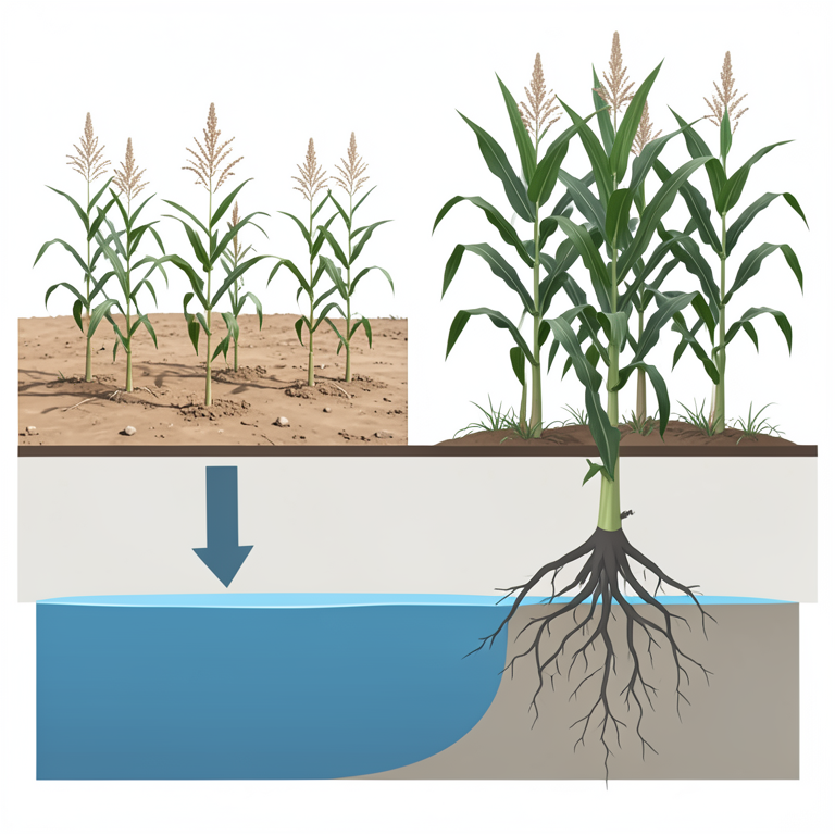
Crop Transition and Water Stress
AI-generated conceptual illustration (Pearl millet, maize, and sugarcane plants in a semi-arid Indian field with an underground aquifer). It explains the idea and does not show study data.
View source evidence ↗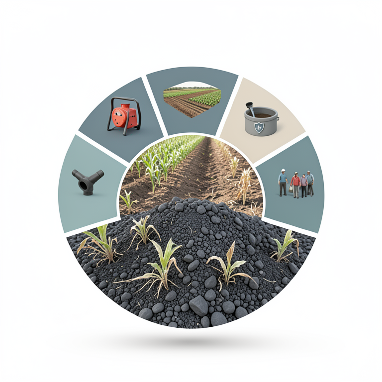
Six-Pillar Governance Framework
AI-generated conceptual illustration (Semi-arid agricultural landscape in Solapur, Maharashtra, featuring basaltic soil and diverse crops). It explains the idea and does not show study data.
View source evidence ↗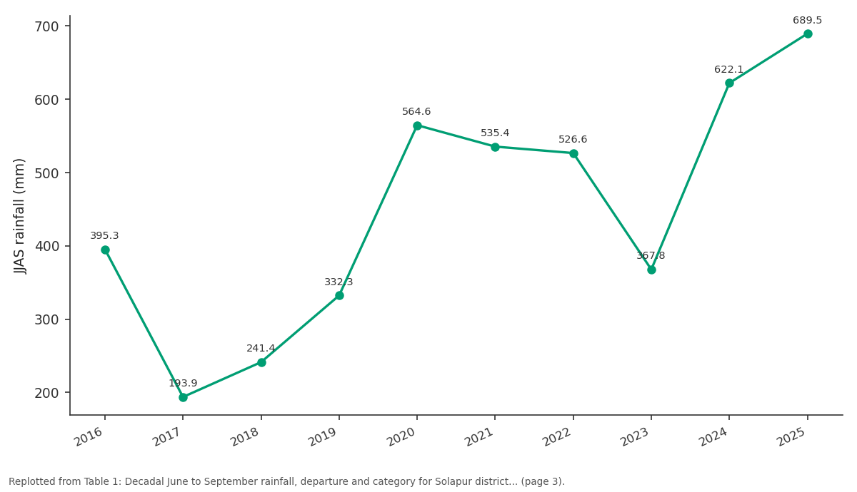
JJAS rainfall (mm): 2016 vs 2017 vs 2018 vs 2019 vs 2020
Replotted from Table 1 (page 3) of the original paper. Every bar is the paper's own table value.
View source evidence ↗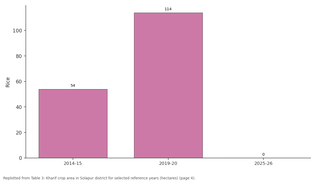
Rice: 2014-15 vs 2019-20 vs 2025-26
Replotted from Table 3 (page 4) of the original paper. Every bar is the paper's own table value.
View source evidence ↗Figures & tables
From the original paper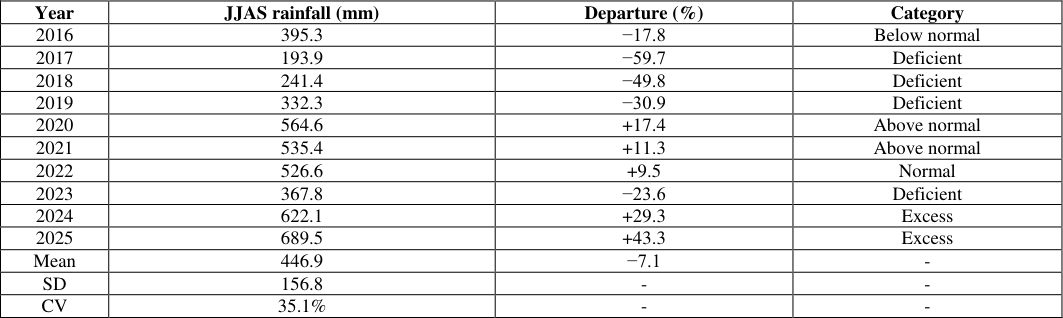 Table 1
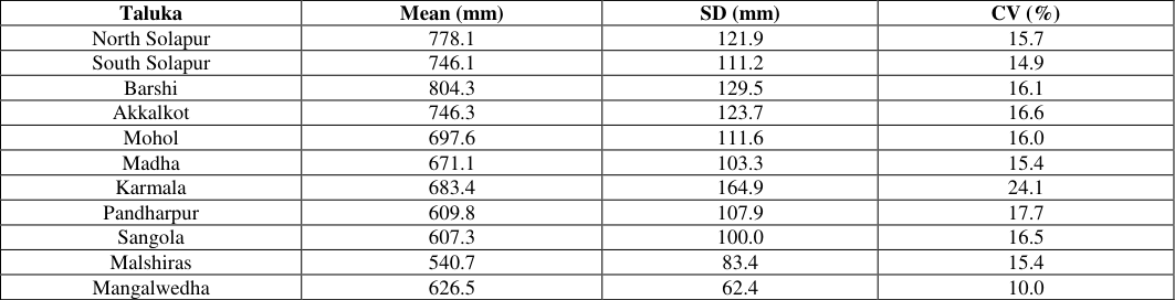 Table 2
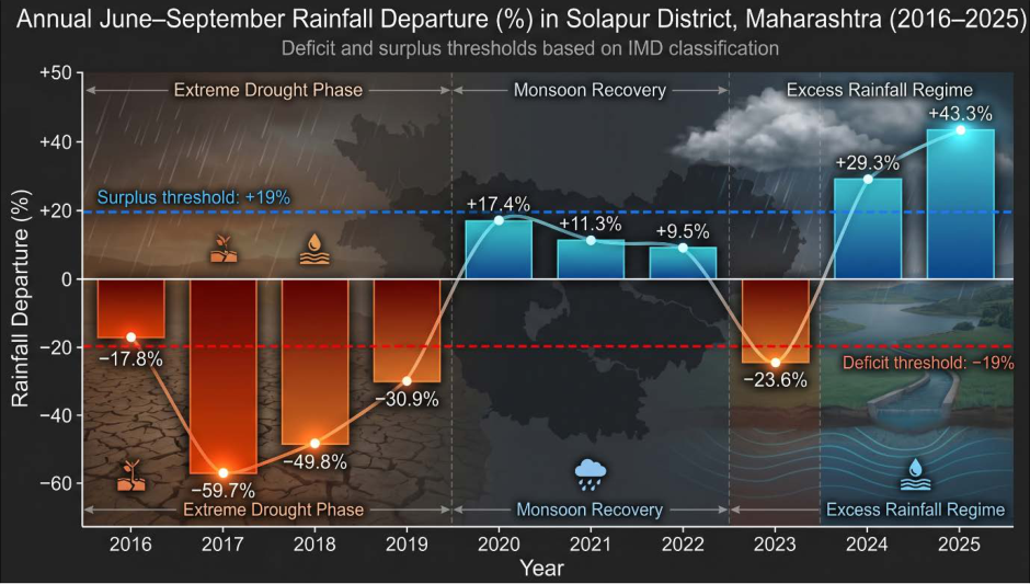 Fig. 1
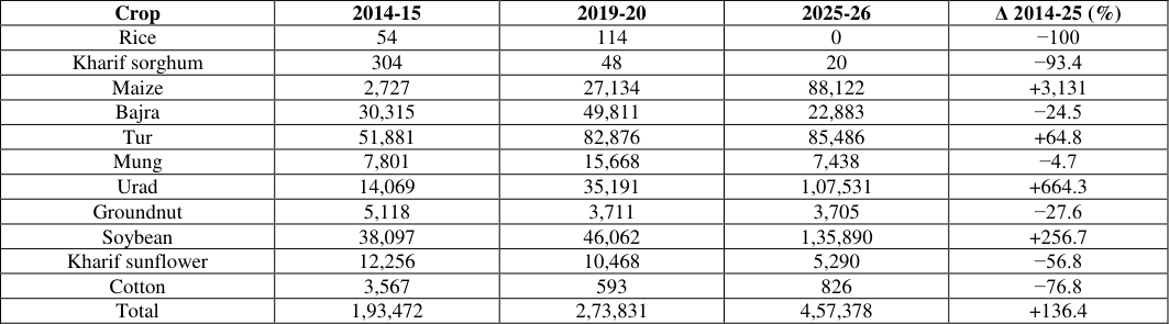 Table 3
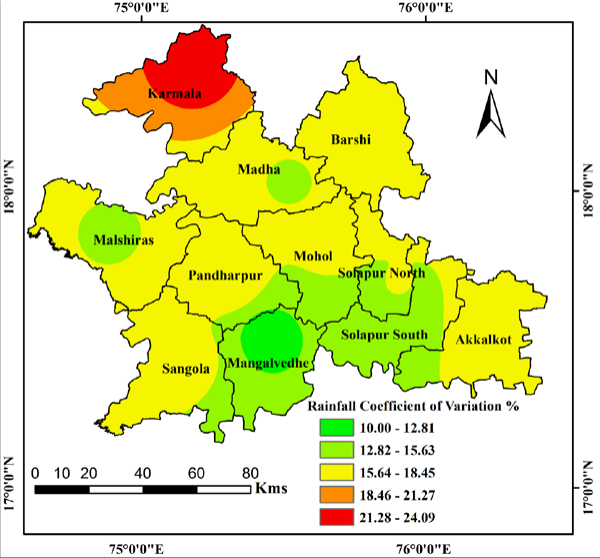 Fig. 2
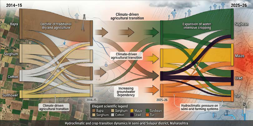 Fig. 3
 Table 4
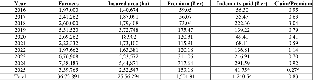 Table 5
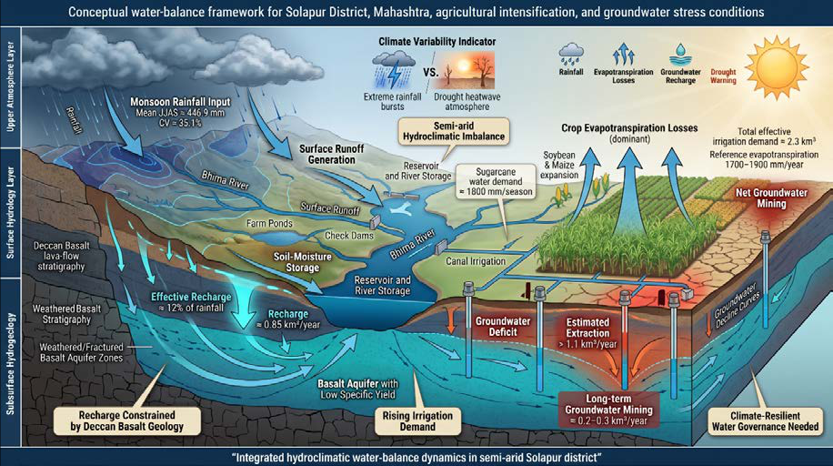 Fig. 4
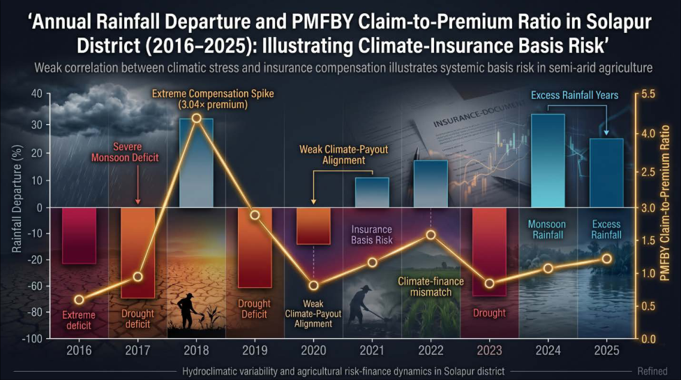 Fig. 5
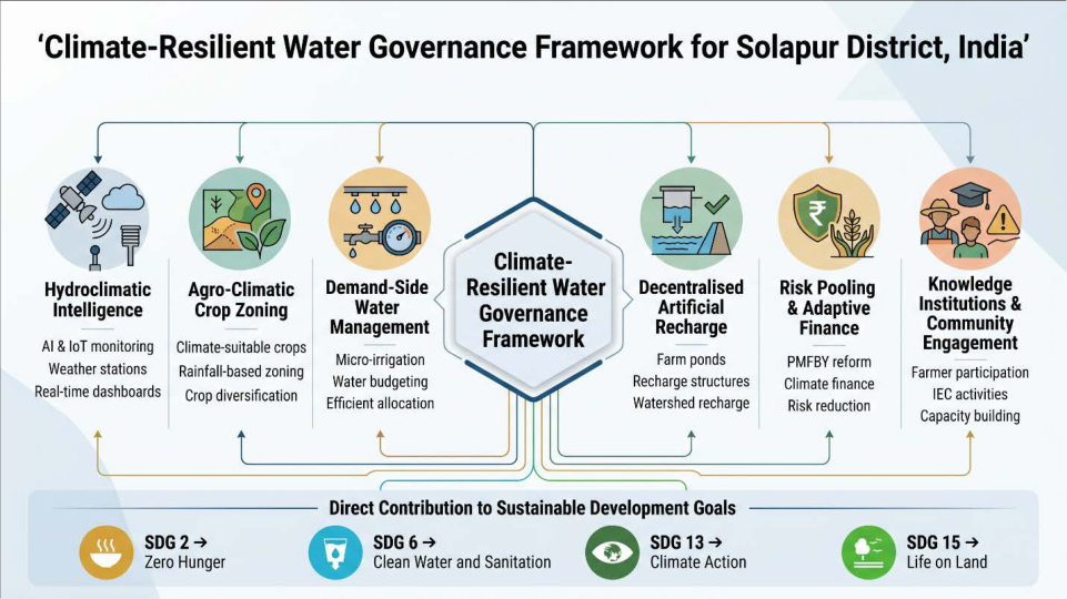 Fig. 6
Introduction
Water shortage and climate variability have become defining constraints on rainfed and partially irrigated agriculture across the global semi-arid belt. About 40% of the world's cultivated land lies in dryland zones and these zones produce close to 44% of global food while supporting more than two billion people. Pressures on water resources have intensified through population growth, expansion of irrigation and rising agricultural input demand. India is at the centre of this picture. Roughly 60% of net sown area is rainfed, two-thirds of districts experience moderate to high drought frequency and groundwater supplies about 63% of irrigation water [3,4,5,6] . Maharashtra has the largest sugarcane area in India and one of the largest semi-arid tracts. The Marathwada and Western Maharashtra plateau receives 400 to 800 mm of annual rainfall but supports a cropping system whose effective water demand routinely exceeds local supply [7,8,9] . Repeated drought years in 2012, 2014, 2015, 2018 and 2023 caused acute distress, with reservoirs at single-digit live storage 10 . Solapur district illustrates these tensions sharply. Mean annual rainfall is around 540 mm and the Köppen classification is BSh. Kharif crops have shifted from bajra, jowar, tur and cotton toward soybean, maize, urad and sugarcane irrigated from the Ujani reservoir on the Bhima. The underlying aquifer is the compact Deccan basalt, with low primary porosity and limited specific yield [11,12] . Hydrogeological studies of the basaltic terrain in Solapur and adjacent Osmanabad have flagged increasing groundwater stress and the need for systematic recharge planning [2,21,22,23,33] .Pandharpur, the pilgrim city in the southwest of the district, has also faced repeated flash floods on the Chandrabhaga, mapped using remote sensing and GIS techniques.Flood-risk mapping of the Chandrabhaga around Pandharpur 1 and watershed prioritisation Studies for Solapur and the Yerala sub-basin [20,24,25] have established the methodological baseline for the present integrated assessment.
Objectives
The objectives of this study are as follows: To characterise decadal rainfall variability and climate trends for the district and its eleven talukas. To document the kharif crop-area transitions between 2014-15 and 2025-26 and link them to effective water demand. To estimate agricultural water demand and assess irrigation sustainability under current cropping. To compare water productivity of water-intensive crops with that of climate-resilient crops. To analyse fertiliser consumption trends and their soilwater-health implications. To evaluate the effectiveness of crop insurance and drought adaptation strategies in the district. To review the role of integrated nutrient management, soil testing and precision agriculture. To assess groundwater sustainability on the Deccan basalt under changing monsoon variability. To identify forward-looking climate risks and agricultural vulnerabilities at taluka scale. To propose a future-ready Climate-Resilient Water Governance framework for semi-arid districts.
Materials and methods
Materials and methods
Study area
Solapur district lies in the southeast of Maharashtra between 17° 05′ to 18° 32′ N and 74° 42′ to 76° 15′ E. The district has a geographical area of about 14,895 km² and is divided into eleven talukas: Akkalkot, Barshi, Karmala, Madha, Malshiras, Mangalwedha, Mohol, North Solapur, Pandharpur, Sangola and South Solapur. The Bhima and its tributaries Sina and Man drain the district. The Ujani reservoir is the largest engineered surface water source. The climate is hot semi-arid (BSh), with mean June to September rainfall of 481.1 mm against reference evapotranspiration of 1,700 to 1,900 mm per year. The district is underlain almost entirely by Cretaceous-Palaeocene Deccan trap basalt, a hard-rock formation with specific yield of 1 to 3% and limited recharge potential [11,12,49] . Soils are dominantly Vertisols and Entisols. Groundwater feasibility in Akkalkot taluka and water-stress mapping for the district have been documented in prior studies [23,38,40] .
Data sources
The primary dataset for this study is the Kharip Hangam 2026 administrative compendium prepared by the Department of Agriculture Solapur. The compendium consolidates monthly rainfall for 2016 to 2025, taluka-wise rainfall for 2021 to 2025, kharif crop area and productivity for 2014-15, 2019-20 and 2025-26, fertiliser allotment and consumption, seed consumption, PMFBY enrolment and indemnity statistics, farm-pond and micro-irrigation coverage, solar-pump applications, agricultural credit disbursement, Ujani reservoir storage and natural-disaster compensation. Long-term climate normals were crossreferenced against India Meteorological Department gridded data. Earlier piezometer-and water-level-based monitoring datasets under the Atal Bhujal Yojana in Solapur [26,28,39] and water-quality monitoring through accredited laboratories in the district 41 were used to triangulate the inferences on aquifer condition and water quality.
Statistical methods
Statistical methods
Coefficient of variation and departure index
The coefficient of variation (CV) was computed as CV (%) = (standard deviation / mean) × 100 for annual June to September rainfall at district scale and for each taluka. The rainfall departure index was computed as D = (Pᵢ -P ̄) / P ̄ × 100, where Pᵢ is rainfall in year i and P ̄ is the long-period average (481.1 mm). India Meteorological Department thresholds were used to classify years as deficient (≤ -19%), normal (-19 to +19%) or excess (≥ +19%).
Mann-Kendall trend and Sen's slope
The non-parametric Mann-Kendall test was applied to annual rainfall to detect monotonic trends at the 95% confidence level. Sen's slope estimator quantified the magnitude in mm per year. These tests are insensitive to non-normality and outliers [17,18] .
Crop-water requirement and water productivity
Crop-Water Requirement (CWR, mm) was estimated using FAO Penman-Monteith reference ET with crop coefficients (K_c) from FAO Irrigation and Drainage Paper No. 56 16 . Typical seasonal CWR values were 500 mm for soybean and tur, 550 mm for maize and sunflower, 400 mm for urad and bajra, 800 mm for cotton and 1,800 mm for sugarcane. Water productivity (WP, kg m⁻³) was computed as yield (kg ha⁻¹) divided by total water depth (mm) converted to volume [13,18] .
Drought frequency and spatial composite
Drought frequency was computed as the fraction of years with rainfall departure below -19% within the ten-year window. A taluka-level composite vulnerability index combined rainfall CV, share of water-intensive crops and the ratio of cropped area to long-term normal. Methodological precedents for multi-criteria prioritisation of water-stress areas in basaltic terrain were drawn from earlier work on the Yerala basin and Osmanabad [20,24,25] . Remote sensing and GIS protocols for groundwater assessment followed established practice for semi-arid India [30] .
Results
Results
Decadal rainfall variability
Annual rainfall for the June to September window over 2016-2025 ranged from 193.9 mm (2017) to 689.5 mm (2025). Mean rainfall was 446.9 mm and standard deviation was 156.8 mm, yielding a coefficient of variation of 35.1%. The Mann-Kendall test returned S = 25, Z = 2.15 (significant at the 95% confidence level) and Sen's slope was +47.5 mm per year. Four out of ten years (2017, 2018, 2019 and 2023) had departures below -19%, qualifying as deficient or drought years. Two years (2024 and 2025) had departures above +29%. 3,131% and tur 65%. Bajra contracted 25%, cotton 77%, kharif sunflower 57% and kharif sorghum 93%. Table 3 presents the full transition matrix.
| Crop | 2014-15 | 2019-20 | 2025-26 | Δ 2014-25 (%) |
|---|---|---|---|---|
| Rice | 54 | 114 | 0 | −100 |
| Kharif sorghum | 304 | 48 | 20 | −93.4 |
| Maize | 2,727 | 27,134 | 88,122 | +3,131 |
| Bajra | 30,315 | 49,811 | 22,883 | −24.5 |
| Tur | 51,881 | 82,876 | 85,486 | +64.8 |
| Mung | 7,801 | 15,668 | 7,438 | −4.7 |
| Urad | 14,069 | 35,191 | 1,07,531 | +664.3 |
| Groundnut | 5,118 | 3,711 | 3,705 | −27.6 |
| Soybean | 38,097 | 46,062 | 1,35,890 | +256.7 |
| Kharif sunflower | 12,256 | 10,468 | 5,290 | −56.8 |
| Cotton | 3,567 | 593 | 826 | −76.8 |
| Total | 1,93,472 | 2,73,831 | 4,57,378 | +136.4 |
Table text extracted from the original PDF; superscript letters are shown inline. The original table image is below.
View original table image
Discussion
Discussion
Rainfall trend and basin-scale implications
The positive Sen's slope of +47.5 mm per year is consistent with all-India model projections of an intensifying yet noisier southwest monsoon over peninsular India [13,14,15] . Within-season variability has risen even more sharply than annual totals. August 2023 received 18.9% of normal rainfall, whereas September 2025 received 208% of normal. Such bimodal behasviour confirms central-India trends in extreme-rainfall frequency 11 and complicates kharif crop planning. The implication for hydrology is twofold: surface runoff peaks become sharper and harder to capture, while shallow aquifer recharge becomes more episodic.
Crop transition and effective water demand
The 137% expansion of kharif area is more striking than national averages of cropping-intensity growth 17 and is dominated by water-intensive crops. Effective seasonal water requirement for the 2025-26 portfolio is on the order of 2.3 km³ at district scale. In drought years effective rainfall on the cropped area falls below 1.5 km³, generating an irrigation deficit of 0.7 to 0.9 km³. Sugarcane on the proposed 2.30 lakh ha would impose an additional 4.1 km³ of demand. This places the district's water budget on a trajectory that the Deccan basaltic aquifer cannot sustain over consecutive dry years 33 .
Groundwater stress and recharge potential
Specific yield in Solapur basalt averages about 2%. Even a generous recharge of 12% of monsoon rainfall amounts to roughly 0.85 km³ of usable annual accretion. Estimated extraction for sugarcane, fruit orchards and water-intensive kharif crops exceeds 1.1 km³. The implied long-run mining rate is 0.2 to 0.3 km³ per year. Karmala, Pandharpur, Sangola and Mangalwedha exhibit the steepest declines [33,40] . Decentralised artificial recharge structures, particularly designed for basaltic mini-watersheds, have shown demonstrable benefits in Osmanabad and the Yerala subbasin [21,25,45] . Their scaling under the Atal Bhujal Yojana in Solapur, with piezometer-based monitoring, has begun to yield calibrated recharge estimates [26,39] .
Fertiliser trends and water quality
Kharif 2025 fertiliser consumption was 2.35 lakh metric tonnes against an allotment of 2.32 lakh metric tonnes. The composition leans heavily on urea and DAP with potash and micronutrients below balanced N:P:K ratios. The integrated nutrient management push under the district's Atma programme demonstrated 10% reduction in fertiliser use without yield loss. Excessive nitrogen application during high-rainfall years 2024 and 2025 is leaching into shallow aquifers, with documented nitrate levels above 45 mg L⁻¹ in pockets of Mohol and South Solapur. The implications for community health are direct [32,41] . A move toward soilhealth-card-linked subsidies and organic farming corridors would address both nutrient balance and water-quality concerns [27,44] .
PMFBY basis risk and adaptive finance
The correlation between rainfall departure and PMFBY indemnity for Solapur is positive but weak (r = +0.41), indicating substantial basis risk. The 2018 settlement of 3.04 times the premium and the 2020 settlement of 0.41 of the premium reflect mismatch between revenue-circle cropcutting experiments and field-level loss. A weather-indexed transition, with automatic weather stations at every revenue circle, would tighten payout-loss alignment. The singleseason natural-disaster compensation of ₹1,639 crore in 2025 dwarfs the PMFBY payout, indicating that the present risk-pooling architecture is incomplete. Pooled climateadaptation funds, with shared subsidies from PMFBY, the State Disaster Response Fund and corporate socialresponsibility contributions, would help [36,44,46] .
Climate-resilient water governance framework
Building on Integrated Water Resources Management principles, nature-based solutions and demand-side water management, the proposed framework rests on six pillars.
Hydroclimatic intelligence
Automation of weather stations at every revenue circle, realtime discharge gauging on the Bhima, Sina and Man, and a public taluka-level dashboard updated daily during the monsoon. The integration of artificial intelligence and Internet-of-Things sensors for groundwater and surface water monitoring has been proposed for Maharashtra [31,42,43] .
Agro-climatic crop zoning
Sugarcane and other long-duration high-evapotranspiration crops should be permitted only in canal-commanded blocks with assured surface water. Soybean, maize and urad should be promoted on assured kharif rainfall pockets (Barshi, Akkalkot, Mohol). Bajra, jowar and pulses should be incentivised in low-rainfall, high-variability talukas (Sangola, Mangalwedha, Malshiras) through price-support floors 27 .
Demand-side water management
Universal micro-irrigation on horticulture and sugarcane within five years; volumetric water pricing for canalcommanded sugarcane; mandatory water-budget statements for any new electricity connection to a borewell deeper than 60 m. Water-harvesting investments at watershed scale have been shown to mitigate drought impacts in Solapur [37,38] .
Decentralised artificial recharge
Continued farm-pond expansion with engineered seepage control; addition of contour bunds and check dams on second-and third-order streams. Recharge shaft technology, as demonstrated at Shetphal, can complement traditional structures in Critical and Over-exploited blocks [45] .
Risk pooling and adaptive finance
Conversion of PMFBY in Solapur to a hybrid weatherindexed scheme; pooling of premium subsidies from PMFBY, natural-disaster compensation and crop loans into a single district climate-adaptation fund; differentiated premium rates for farmers using micro-irrigation and certified climate-resilient seed 44 .
Knowledge institutions and community engagement
Scaling of farmer producer companies, expansion of organic and natural-farming clusters under PKVY and integration with information, education and communication tools deployed under the Atal Bhujal Yojana [26,28,29] . Engaging communities through public exhibitions, water-quality literacy programmes and ecosystem-level awareness has been shown to influence groundwater behavior [32,34,48] .
Sustainable Development Goal linkages
The findings have implications for SDG 2 (zero hunger), SDG 6 (clean water and sanitation), SDG 13 (climate action) and SDG 15 (life on land). Aligning cropping decisions with rainfall reality safeguards food production. Demand-side water management and recharge protect drinking water and aquifer integrity. Crop insurance and adaptive finance build farmer resilience to climate extremes. Soil-health-linked nutrient management and natural farming halt land degradation. The six-pillar framework operationalises these linkages at district scale and is replicable across the basaltic belt of Maharashtra and Karnataka [34,35,42,50] .
Policy gaps and reform priorities
Policy gaps and reform priorities
Acknowledgement
AcknowledgementThe authors thank the Department of Agriculture, Zilla Parishad Solapur, for access to the Kharip Hangam 2026 administrative compendium and the Groundwater Surveys and Development Agency (GSDA), Maharashtra, for piezometer and groundwater monitoring datasets under the Atal Bhujal Yojana. The corresponding author acknowledges the institutional support provided by GSDA Solapur. The authors received no specific external funding for this work.
Figures and tables from the paper
| Year | JJAS rainfall (mm) | Departure (%) | Category |
|---|---|---|---|
| 2016 | 395.3 | −17.8 | Below normal |
| 2017 | 193.9 | −59.7 | Deficient |
| 2018 | 241.4 | −49.8 | Deficient |
| 2019 | 332.3 | −30.9 | Deficient |
| 2020 | 564.6 | +17.4 | Above normal |
| 2021 | 535.4 | +11.3 | Above normal |
| 2022 | 526.6 | +9.5 | Normal |
| 2023 | 367.8 | −23.6 | Deficient |
| 2024 | 622.1 | +29.3 | Excess |
| 2025 | 689.5 | +43.3 | Excess |
| Mean | 446.9 | −7.1 | - |
| SD | 156.8 | - | - |
| CV | 35.1% | - | - |
Table text extracted from the original PDF; superscript letters are shown inline. The original table image is below.
View original table image
| Taluka | Mean (mm) | SD (mm) | CV (%) |
|---|---|---|---|
| North Solapur | 778.1 | 121.9 | 15.7 |
| South Solapur | 746.1 | 111.2 | 14.9 |
| Barshi | 804.3 | 129.5 | 16.1 |
| Akkalkot | 746.3 | 123.7 | 16.6 |
| Mohol | 697.6 | 111.6 | 16.0 |
| Madha | 671.1 | 103.3 | 15.4 |
| Karmala | 683.4 | 164.9 | 24.1 |
| Pandharpur | 609.8 | 107.9 | 17.7 |
| Sangola | 607.3 | 100.0 | 16.5 |
| Malshiras | 540.7 | 83.4 | 15.4 |
| Mangalwedha | 626.5 | 62.4 | 10.0 |
Table text extracted from the original PDF; superscript letters are shown inline. The original table image is below.
View original table image
| Crop | Area 2025 (ha) | Yield (kg ha⁻¹) | CWR (mm) | WP (kg m⁻³) |
|---|---|---|---|---|
| Soybean | 1,35,890 | 621 | 500 | 0.124 |
| Maize | 88,122 | 2,233 | 550 | 0.406 |
| Tur | 85,486 | 592 | 500 | 0.118 |
| Urad | 1,07,531 | 540 | 400 | 0.135 |
| Bajra | 22,883 | 406 | 400 | 0.102 |
| Sunflower | 5,290 | - | 550 | - |
| Cotton | 826 | - | 800 | - |
| Sugarcane | 1,82,436 | 95,000 | 1,800 | 5.28 |
Table text extracted from the original PDF; superscript letters are shown inline. The original table image is below.
View original table image
| Year | Farmers | Insured area (ha) | Premium (₹ cr) | Indemnity paid (₹ cr) | Claim/Premium |
|---|---|---|---|---|---|
| 2016 | 1,97,000 | 1,40,674 | 59.05 | 56.30 | 0.95 |
| 2017 | 2,41,262 | 1,87,091 | 56.07 | 35.47 | 0.63 |
| 2018 | 2,60,000 | 1,79,408 | 73.04 | 222.36 | 3.04 |
| 2019 | 5,31,520 | 3,72,748 | 175.47 | 139.22 | 0.79 |
| 2020 | 2,69,262 | 18,902 | 120.31 | 49.41 | 0.41 |
| 2021 | 2,22,332 | 1,73,100 | 115.91 | 68.11 | 0.59 |
| 2022 | 1,97,662 | 1,63,381 | 120.18 | 136.81 | 1.14 |
| 2023 | 6,76,908 | 5,23,572 | 311.06 | 216.91 | 0.70 |
| 2024 | 7,38,183 | 5,44,871 | 317.64 | 291.59 | 0.92 |
| 2025 | 3,39,765 | 2,52,547 | 153.18 | 41.75* | 0.27* |
| Total | 36,73,894 | 25,56,294 | 1,501.91 | 1,240.54 | 0.83 |
Table text extracted from the original PDF; superscript letters are shown inline. The original table image is below.
View original table image
References
50 in the original paper- Shaikh MA. Mapping of flood risk zones of Chandrabhaga River around the pilgrim city of Pandharpur by using remote sensing, DEM and GIS techniques. Int J Sci Res. 2015;4(4):513-515. doi:10.21275/SUB153067.
- Shaikh MA, Birajdar F. Anticipation of water scarcity impacted areas and duration: A case study of Osmanabad District, Maharashtra, India. Int J Latest Technol Eng Manage Appl Sci. 2015;4(3):1-5.
- Food and Agriculture Organization of the United Nations. The state of the world's land and water resources for food and agriculture: Systems at breaking point. Rome: FAO; 2021. p.13-88.
- Intergovernmental Panel on Climate Change. Climate change 2022: Impacts, adaptation and vulnerability. Contribution of Working Group II to the Sixth Assessment Report. Cambridge: Cambridge University Press; 2022. p.1-3068.
- Central Ground Water Board. National compilation on dynamic ground water resources of India, 2022. Faridabad: Ministry of Jal Shakti, Government of India; 2022. p.1-321.
- NITI Aayog. Composite Water Management Index 2.0. New Delhi: NITI Aayog, Government of India; 2019. p.1-178.
- Udmale P, Ichikawa Y, Manandhar S, Ishidaira H, Kiem AS. Farmers' perception of drought impacts, local adaptation and administrative mitigation measures in Maharashtra State, India. Int J Disaster Risk Reduct. 2014;10:250-269.
- Mishra V, Aadhar S, Asoka A, Pai S, Kumar R. On the frequency of the 2015 monsoon-season drought in India. Geophys Res Lett. 2019;46(2):1027-1035.
- Government of Maharashtra. Report of the Maharashtra State Drought Assessment Committee. Mumbai: Department of Relief and Rehabilitation; 2019. p.1-142.
- Goswami BN, Venugopal V, Sengupta D, Madhusoodanan MS, Xavier PK. Increasing trend of extreme rain events over India in a warming environment. Science. 2006;314(5804):1442-1445.
- Maréchal JC, Dewandel B, Ahmed S, Lachassagne P. Hard-rock aquifers characterization prior to modelling at catchment scale: Application to the Maheshwaram catchment, India. Geosci Front. 2018;9(1):121-135.
- Pavelic P, Patankar U, Acharya S, Jella K, Gumma MK. Role of groundwater in buffering irrigation production against climate variability at the basin scale in southwest India. Agric Water Manag. 2012;103:7887.
- Krishnan R, Sanjay J, Gnanaseelan C, Mujumdar M, Kulkarni A, Chakraborty S. Assessment of climate change over the Indian region. Singapore: Springer; 2020. p.1-226.
- Guhathakurta P, Rajeevan M. Trends in the rainfall pattern over India. Int J Climatol. 2008;28(11):14531469.
- Kothawale DR, Rajeevan M. Monthly, seasonal and annual rainfall time series for all-India, homogeneous regions and meteorological subdivisions: 1871-2016. IITM Research Report RR-138. Pune: Indian Institute of Tropical Meteorology; 2017. p.1-169.
- Allen RG, Pereira LS, Raes D, Smith M. Crop evapotranspiration: Guidelines for computing crop water requirements. FAO Irrigation and Drainage Paper No. 56. Rome: Food and Agriculture Organization of the United Nations; 1998. p.1-300.
- Kendall MG. Rank correlation methods. 4th ed. London: Charles Griffin and Co.; 1975. p.1-202.
- Sen PK. Estimates of the regression coefficient based on Kendall's tau. J Am Stat Assoc. 1968;63(324):13791389.
- Niranjan Kumar K, Rajeevan M, Pai DS, Srivastava AK, Preethi B. On the observed variability of monsoon droughts over India. Weather Clim Extrem. 2013;1:4250.
- Shaikh MA, Birajdar F. Analysis of watershed characteristics using remote sensing and GIS techniques. Int J Innov Res Sci Eng Technol. 2015;4(4):1971-1976. doi:10.15680/IJIRSET.2015.0404023.
- Shaikh MA, Birajdar F. Groundwater assessment and feasibility of artificial recharge structures on overexploited miniwatersheds of MR-12, Osmanabad District. In: Proceedings of the 2015 International Conference on Technologies for Sustainable Development (ICTSD); 2015; Mumbai, India. p.1-5. doi:10.1109/ICTSD.2015.7095916.
- Shaikh MA, Birajdar F. Mapping of water scarce zones of Osmanabad District by analysis of groundwater levels and rainfall. Int J Innov Eng Technol. 2015;5(2):254-262.
- Shaikh M, Birajdar F. Mapping of feasibility of groundwater for drinking water zones of Akkalkot Taluk, Solapur, India using GIS techniques. Int J Sci Res. 2015;4(4):1709-1713. doi:10.21275/15041507.
- Shaikh MA, Herlekar MA, Umrikar B. Evaluation of multiple hydrometeorological factors for prioritization of water stress areas in the Upper Yerala River Basin, Satara, Maharashtra, India. In: Techno-Societal 2016. Cham: Springer; 2018. p.45-53. doi:10.1007/978-3319-53556-2_5.
- Shaikh MA, Herlekar MA, Umrikar B. Appraisal of artificial recharge zones for groundwater in basaltic terrain of Upper Yerala River Basin, Maharashtra. J Geosci Res. 2019;Special Volume 2:29-36.
- Shaikh MA, Birajdar F. Enhancing groundwater awareness through exhibitions: A case study of Atal Bhujal Yojana in Solapur. Int J Novel Res Dev. 2023;8(12). doi:10.1729/Journal.37421.
- Shaikh MA, Birajdar F. Groundwater management and sustainable farming practices: A socioeconomic analysis of their interplay in rural agriculture, a case study of Solapur, Maharashtra, India. Int J Innov Sci Res Technol. 2023;8(9):1543-1551. doi:10.5281/zenodo.8402903.
- Shaikh MA, Birajdar F. Groundwater awareness using various IEC tools in Atal Bhujal Yojana at Solapur District. Int J Res Trends Innov. 2023;8(9):8-14.
- Shaikh MA, Birajdar F. GIS-based multi-criteria evaluation techniques for demarcation of solid waste disposal site locations in Solapur City, Maharashtra, India. Int J Novel Res Dev. 2023;8(4).
- Shaikh MA, Birajdar F. Advancements in remote sensing and GIS for sustainable groundwater monitoring: Applications, challenges and future directions. Int J Res Eng Sci Manage. 2024;7(3):16-24.
- Shaikh MA, Birajdar F. Artificial intelligence in groundwater management: Innovations, challenges and future prospects. Int J Sci Res Arch. 2024;11(1):502512. doi:10.30574/ijsra.2024.11.1.0105.
- Shaikh MA, Birajdar F. Groundwater and public health: Exploring the connections and challenges. Int J Innov Sci Res Technol. 2024;9(2):1351-1362. doi:10.5281/zenodo.10730864.
- Shaikh MA, Birajdar F. Groundwater depletion in agricultural regions: Causes, consequences and sustainable management, a case study of basaltic terrain of Solapur District. EPRA Int J Multidiscip Res. 2024;10(2):237-242. doi:10.36713/epra15862.
- Shaikh MA, Birajdar F. Groundwater and ecosystems: Understanding the critical interplay for sustainability and conservation. EPRA Int J Multidiscip Res. 2024;10(3):181-186. doi:10.36713/epra16111.
- Shaikh MA, Birajdar F. Role of State Government of Maharashtra, Central Government of India, and nongovernment organizations in watershed management. Int Res J Innov Eng Technol. 2024;8(2):109-122. doi:10.47001/IRJIET/2024.802016.
- Shaikh MA, Birajdar F. Harmony in hydroinformatics: Integrating AI and IEC for sustainable groundwater conservation in Solapur. Int J Sci Res Arch. 2024;11(1):502-512. doi:10.30574/ijsra.2024.11.1.0105.
- Shaikh MA, Birajdar F. Water harvesting importance and techniques for mitigating drought in Solapur District. Int J Res Eng Sci Manage. 2024;7(2):74-83.
- Shaikh MA, Birajdar F. Water scarcity in Solapur: Mitigation strategies and sustainable planning. Int J Innov Sci Eng Technol. 2024;11(1):56-71.
- Shaikh MA, Birajdar F. Advancing sustainable water management in Solapur through continuous groundwater monitoring with piezometers and automatic water level recorders: Insights from the Atal Bhujal Yojana. Int J Innov Sci Res Technol. 2024;9(2). doi:10.5281/zenodo.10656174.
- Shaikh MA, Birajdar F. Water scarcity in Solapur: Mitigation strategies and sustainable planning (companion paper). Int J Innov Sci Eng Technol. 2024;11(1):56-71.
- Shaikh MA, Birajdar F. Ensuring purity and health: A comprehensive study of water quality testing labs in Solapur District for community well-being. Int J Innov Sci Res Technol. 2024;9(1):271-281. doi:10.5281/zenodo.10622956.
- Shaikh MA, Birajdar F. Smart watersheds, smarter governance: A unified AI-GIS-IoT framework for climate-resilient Maharashtra. Int J Innov Sci Res Technol. 2025;IJISRT25JUN376:213-224. doi:10.38124/ijisrt/25jun376.
- Shaikh MA, Birajdar F. Advancing groundwater resource management through artificial intelligence: Future directions for GSDA Solapur. Int Sci J Eng Manage. 2025;4(5):1-10. doi:10.55041/ISJEM03791.
- Shaikh MA, Birajdar F. Economic impacts of collective farming and groundwater management in droughtprone regions: A Solapur case study. Int J Latest Technol Eng Manage Appl Sci. 2025;14(9):830-841. doi:10.51583/IJLTEMAS.2025.1409000097.
- Shaikh MA, Birajdar F. Site selection to community handover: Effective recharge shaft development for rural water security in Shetphal, Maharashtra. Int J Res Innov Appl Sci. 2025;10(9). doi:10.51584/IJRIAS.2025.100900030.
- Shaikh MA, Birajdar F. Unveiling social barriers to water scarcity adaptation in Solapur's Deccan basaltic terrain: A grounded theory approach. Int Res J Modernization Eng Technol Sci. 2025;7(6):2363-2374. doi:10.56726/IRJMETS79575.
- Shaikh MA, Birajdar F. Policy innovations for sustainable aggregates: Maharashtra's M-Sand strategy in a global context. Int J Res Sci Innov. 2025;12(8). doi:10.51244/IJRSI.2025.120800152.
- Shaikh MA, Birajdar F. The dual hydrological impact of celebrity-driven water conservation initiatives in the Deccan basaltic terrain of Solapur District, Maharashtra: A critical analysis. Asian J Geogr Res. 2025;8(4):224-237. doi:10.9734/AJGR/2025/v8i4331.
- Shaikh MA, Birajdar F. Seismo-acoustic coupling in microseismic events: Evidence from the Deccan Volcanic Province, Maharashtra, India. Int J Geogr Geol Environ. 2025;7(10):7-16.
- Shaikh MA, Birajdar F. From policy to practice: A governance case study of rural water supply implementation under India's Jal Jeevan Mission. Asian J Geol Res. 2026;9(1):149-172. doi:10.9734/AJOGER/2026/v9i1233.