
Research article · 2026 · Full text
International Journal of Geography Geology and EnvironmentTechnical and environmental mechanisms for water resources sustainability in the Middle Euphrates region
Volume 8(6) · Pages 15–22 · DOI: 10.22271/27067483.2026.v8.i6a.780 ↗
Research areasTransboundary Water Resource ManagementIntegrated Water Resources ManagementWater resources management and optimization
Abstract
Author-writtenWater resources in the Euphrates River basin have witnessed a sharp decline recently, particularly in the Middle Euphrates region of Iraq, due to a combination of natural and human factors. This research aims to study the geographical extent of the Euphrates River and identify the most prominent challenges facing water resource management within it. These challenges include harsh climate change, policies of upstream countries towards downstream countries, and the worsening problem of environmental pollution. The research adopted a descriptive-analytical approach to assess the current water situation and reviewed several old and new methods and technologies that could contribute to the preservation and sustainability of water resources, such as rainwater harvesting, developing irrigation systems, and implementing water treatment. The research concluded that the water crisis in the Middle Euphrates is a complex and multifaceted crisis (both quantitative and qualitative), and that fundamental solutions lie in transitioning to smart water management, controlling pollutants, and activating water diplomacy to ensure equitable water allocations
Summary
Source-checkedPlain-language reading of the full paper, prepared with AI and checked against the text. Each point links to the authors' own words.
Why it matters
- Water resources are fundamental to the environmental and economic stability of the Euphrates River basin. View evidence ↗
- Water security in the Middle Euphrates is threatened by climate change, which causes droughts and evaporation, and the dam-building policies of upstream countries. View evidence ↗
- The region faces a dual crisis of water scarcity and deteriorating water quality caused by industrial, agricultural, and human pollution. View evidence ↗
The question
- The study aims to analyze the geographical extent of the Euphrates River and identify the primary challenges to managing its water resources. View evidence ↗
What they did
- The researchers used a descriptive-analytical approach to evaluate the current water status and review existing and modern sustainability technologies. View evidence ↗
- The study area is defined by latitudes 3.29° to 24.33° N and longitudes 46.39° to 48.42° E, covering the Iraqi governorates of Babylon, Karbala, Najaf, Diwaniyah, and Muthanna. View evidence ↗
What they found
- Average temperatures in the region range from a low of 10.6 in January to a high of 35.7 in July. View evidence ↗
- The overall average effective rainfall is 4.34, with Najaf recording the highest (4.73) and Samawah the lowest (4.07). View evidence ↗
- The region experiences a water deficit every month of the year except for December, which has a surplus of 3.4. View evidence ↗
- Turkey's GAP system relies on 80% of the Euphrates' water and has a storage capacity of 128 billion cubic meters. View evidence ↗
- River salinity is projected to reach 1450 parts per million annually by 2025 at the point where the river enters Iraq. View evidence ↗
- Flood irrigation, used in approximately 97% of Iraqi irrigation, contributed to salt layers covering about 5,288,000 dunams in 2008. View evidence ↗
- Improved irrigation can increase production by 60% without water loss; for instance, tomato yields increase from 30 tons/hectare with surface irrigation to 70 tons/hectare. View evidence ↗
- Sprinkler irrigation systems are highly efficient, saving approximately 75% of water. View evidence ↗
- Reverse osmosis desalination units in Basra's petrochemical and fertilizer plants produce an estimated 7.4 million cubic meters of water per year. View evidence ↗
What it means
- The authors conclude that the Middle Euphrates water crisis is multifaceted and requires smart water management, pollutant control, and active water diplomacy for equitable allocation. View evidence ↗
- The authors note a lack of published research regarding water harvesting and collection methods. View evidence ↗
Visual summary
3 visualsIllustrations explain the paper; charts are replotted from the paper's own table values.
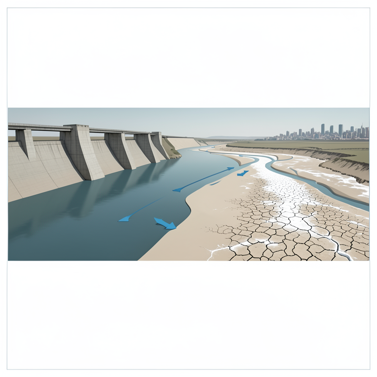
Water Security Pressure Map
AI-generated conceptual illustration (The Euphrates River basin flowing through an arid landscape). It explains the idea and does not show study data.
View source evidence ↗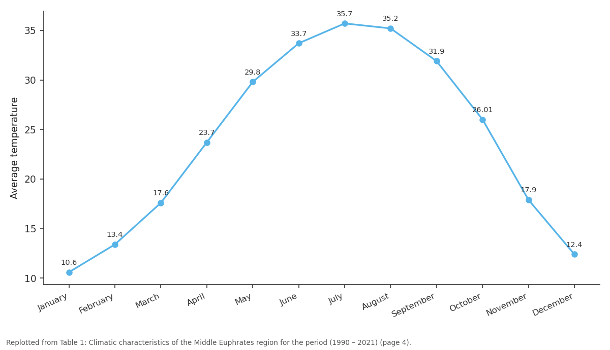
Average temperature: January vs February vs March vs April vs May
Replotted from Table 1 (page 4) of the original paper. Every bar is the paper's own table value.
View source evidence ↗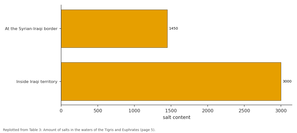
salt content: At the Syrian-Iraqi... vs Inside Iraqi territory
Replotted from Table 3 (page 5) of the original paper. Every bar is the paper's own table value.
View source evidence ↗Figures & tables
From the original paper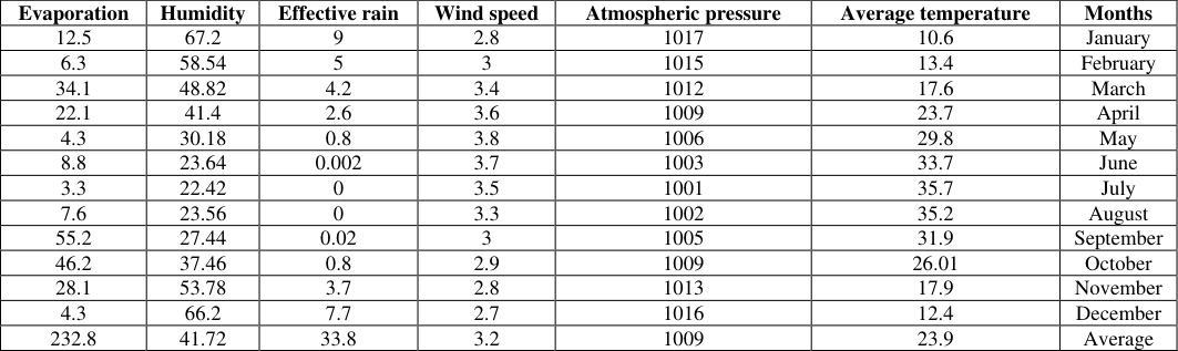 Table 1
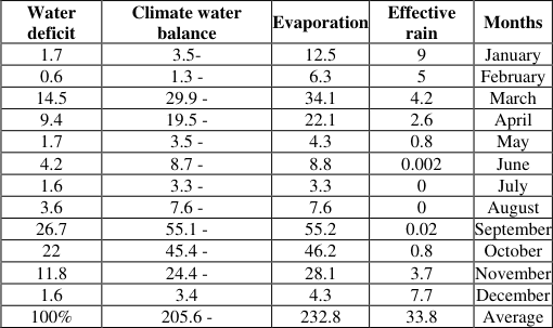 Table 2
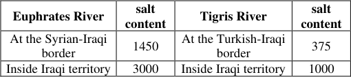 Table 3
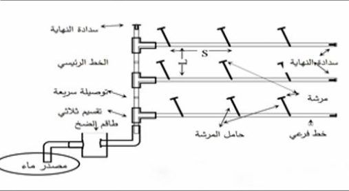 Figure 1
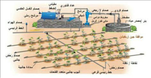 Figure 2
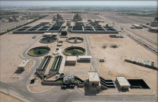 Figure 3
Introduction
Water is the backbone of the Euphrates River basin's environmental and economic stability. This region's unique geographical and developmental characteristics make it highly vulnerable to even the slightest fluctuations in the water levels of this vital artery. Water security in the Middle Euphrates region faces numerous and unprecedented threats, intertwined with various regional dimensions. These include the water policies of upstream neighboring countries and their construction of large dams, as well as natural factors resulting from climate change, which has led to recurring droughts and increased evaporation rates. This crisis is not limited to water scarcity; it extends to the deterioration of water quality due to pollution from local human, agricultural, and industrial activities. Faced with this complex reality, it has become essential to move beyond traditional methods and adopt modern technologies and approaches to achieve sustainability and conserve and protect water resources. This research aims to address this issue through its formulation and analysis, fostering the exchange of expertise and cooperation to achieve and guarantee sustainability for future generations.
Chapter One / Theoretical Framework and Geographical Extent of the Euphrates River Basin First / Theoretical Framework of the Research Research Problem 1
The main problem lies in the sharp decline in the volume of flowing water, coupled with a rapid deterioration in its quality. The problem can be formulated through the following key questions a) Does the current water management system in the Middle Euphrates region possess the necessary environmental and technical mechanisms to ensure the sustainability of water resources and protect them from pollution and waste? b) To what extent do geopolitical challenges and climate change contribute to reducing the water allocations to the Middle Euphrates region?
Research Hypothesis "Adopting technical mechanisms (such as desalination, wastewater treatment, smart irrigation and water harvesting technologies) and activating strict administrative and environmental standards represents a strategic and inevitable solution to confront political challenges and climate changes, and achieves qualitative and quantitative sustainability of water resources in the Middle Euphrates region.
Research Objectives a) To identify and characterize the geographical and hydrological dimensions of the Euphrates River within the study area and assess the current water balance. b) To identify challenges and measure the impact of upstream countries' policies and climate change, and to monitor the source of environmental pollution affecting the river and its tributaries. c) To review and propose the most efficient modern and sustainable technologies for water conservation and to develop a future vision for decision-makers to protect the region's water security.
The importance of the research
The importance of the research lies in providing a practical framework and applied recommendations that enable governmental institutions (such as the Ministry of Water Resources and the Middle Euphrates Environment and Agriculture Directorates) to develop water crisis management strategies and move towards smart irrigation and planning.
Research Methodology
The research relied on descriptive and analytical methods to assess the extent of the impact of old and modern technologies on the sustainability of water resources in the region
Boundaries of the Study Area
The spatial boundaries are astronomically defined as between latitudes 3.
Secondly / The geographical extent of the Euphrates River basin
The water resources of the Euphrates River in Iraq are among the most important. These resources depend on the amount of rain and snow that falls in the river basin and on the operating policies of reservoirs and dams in Iran, Turkey, and Syria [1] . Cities are linked to their proximity to the river's course, as these areas are centers of human Months with high rainfall are characterized by low temperatures, while hot months record no rainfall or very little. Table (1) shows that the highest average temperature is during July, reaching (35.7), while the lowest is during January, recording (10.6). The second factor is rainfall, which is the main source of replenishment for the Tigris and Euphrates basins. The amount, type, intensity, and temporal and spatial distribution of rainfall affect the amount of water stored, as do factors of evaporation, transpiration, seepage, and variation in rainfall amounts. As for the low-pressure systems passing through Iraq, most studies agree that the number of arriving low-pressure systems is about (77)
during the period between November and May, divided into (48) Between November and February, and between March and May (29), effective rainfall is the portion that can be utilized to meet crop needs after excluding deep infiltration and losses due to evaporation and surface runoff. Table (1) shows that the overall average value of effective rainfall is (4.34), with the highest value in Najaf (4.73) and the lowest in Samawah (4.07). Relative humidity was highest in January at an average of (67.2) and lowest in July at (22.42). This indicates that humidity increases in the colder months due to lower temperatures, increased condensation, slower wind speeds, and reduced evaporation, reaching (12.5). This contributes to increased groundwater levels and the retention of surface water for extended periods. Conversely, humidity decreases in the summer, leading to increased transpiration and higher temperatures, resulting in drought.
This necessitates the consumption of large quantities of water and more frequent irrigation in the Middle Euphrates governorates. Atmospheric pressure and wind speed reach their highest levels during the colder months of the year. To (1017) and it decreases in the summer to (1001) as a result of the passage of the hot Indian monsoon low. As for the wind speed as an average general rate, it reaches (3.2) m/s, and the movement is more active during the summer. Table (1) accurately shows that the pressure system in the Middle Euphrates stations (sharp summer decrease and winter increase) means a wind environment that leads in both seasons to a shortage of water. In the winter, the winds and high pressure prevent rainfall, while in the summer, the active dry winds stimulate increased evaporation and stir up dust. This puts the water management in the region in front of a complex and compound climatic challenge
Calculating the water balance in the Middle Euphrates region
The balance means determining the relationship between the components of the hydrological cycle by calculating the relationship between the amount of rainfall and the amount of water lost by the region in various forms. Most of the study areas are located within the continental environment with an arid climate. Therefore, the input element is rainfall and the output is evaporation/transpiration, which means the loss of water from surfaces and from the ground. Therefore, the balance here is the result of subtracting evaporation from rainfall. If it is positive, it means a surplus, and if it is negative, it means a deficit. Table No. (2) shows that the region suffers from a deficit in all months of the year except December, which reached (3.4). This is attributed to the decrease in temperatures, the increase in rainfall, and the decrease in evaporation. As for the rest of the year, as a result of the increase in temperatures and the increase in evaporation, especially from May to October, it suffers from a large water deficit
Second: Water Policy of Neighboring Countries
Iraq's primary reliance on the Tigris and Euphrates rivers to secure its water needs, and the fact that their sources lie outside Iraqi borders, makes this a critical issue for water security. This also creates a geopolitical dimension to water problems, as the nature of these rivers necessitates a special relationship with the countries they flow through, favoring upstream countries at the expense of downstream ones. Iraq's water situation is intertwined with several countries, primarily Turkey, given that the river's source is there. Any project or dam constructed in Turkey could affect the river's water volume. For example, the continued construction of the GAP (Ground-Sea Conduit) system allows Turkey to exert control over the water, as it comprises 13 main projects (6 on the Tigris and 7 on the Euphrates), in addition to other secondary projects. It relies on 80% of the Euphrates' water, and its storage capacity is 128 billion cubic metres. This storage is double Turkey's annual storage capacity, posing a threat to Iraq's water security. Therefore, Iraq must improve its relationship with Turkey and conclude agreements for a fair water-sharing arrangement to ensure its sustainability. The Ilisu Dam project is another threat to water security in Iraq. Iraq and Turkey aim to irrigate approximately 4.2 million dunams of agricultural land through this project. Syria also aspires to a project on the Tigris River to irrigate approximately 556,000 dunams, which translates to about 1.3 billion cubic meters of river water annually reaching Iraq. This would mean the destruction of the Iraqi environment and a decrease in annual water flow of approximately 1 cubic meter, resulting in 26,000 dunams being taken out of agricultural production
Thirdly / Pollution
The Tigris and Euphrates rivers are among the most polluted environmental elements, as they serve as outlets for wastewater from human activities. This is exacerbated by the decrease in river flow, which weakens the river's natural processes and leads to water pollution. Among the pollutants are algae, which obstruct the river's flow. The concentration of algae increases in the south, coinciding with the abundance of pollutants in the central and southern parts of the river and the decrease in flow. It is expected that the salinity level in the river will reach 1450 parts per million annually by 2025, when the river enters Iraqi territory. This, in addition to the decline in the river's physical, biological, and chemical properties, results in a decrease in agricultural production and the reliance on flood irrigation, which accounts for approximately 97% of irrigation in Iraq. This method, combined with rising temperatures and increased water salinity, results in saline soil with layers of salt that covered approximately 5,288,000 dunams in 2008. This situation will worsen in the future if left unaddressed. Furthermore, there is the presence of industrial waste, estimated at approximately 320,000 cubic meter Year [10] .
Chapter Three / Modern Methods and Technologies for Sustainable Water Resources (Practical Aspect)
The mechanisms that implement a range of methods with patterns that enable control over the amount of water to be used, contribute to putting an end to water waste, and achieve the required balance between water use and the cost of providing it, i.e., the sustainable use of water. There are a set of procedures that we follow to ensure proper water sustainability, including:
Water Storage Technologies
This means adding new water for multiple purposes, which is a process of storing water in high-capacity dams on the Euphrates River, such as the Haditha Dam, which was designed to prevent floods, generate electricity, and irrigate agriculture in the Middle Euphrates region. It is the second largest dam in Iraq and stores an estimated amount of (8.2) billion m³. The second is the Fallujah Dam, which was completed in 1985 on the Euphrates River, (5) km south of Fallujah. It has ten openings in the form of crescent-shaped gates, ( 16) m wide and (5.8) m high, and it works to regulate the discharge of both the Ramadi and Hindiya dams. The third is the Ramadi Dam, which was built west of Ramadi at a distance of (2) km to store water and discharge (3600) m3/s into the Euphrates River. It has 24 openings with iron gates, each of which is (6) wide, and ships pass through them. There is a bridge on top of it for the passage of heavy transport vehicles. The fourth is the Hindiya Dam, which is located south of Musayyib within Babylon and on the Euphrates River. It was built during 1913, and the goal is to preserve water resources to raise the water level of the Tigris. The fifth is the Kufa Dam, which is part of the Kifl/Shamiya irrigation project and discharges (1400) m3/s and has seven gates. It irrigates the lands of the Kufa and Abbasiya banks and with a water rationing rate of (40%). The project was completed in full in 1988. The last is the Shamiya Dam, which is located on the city of Shamiya in Diwaniyah and discharges (1100) m3/s into the Shamiya bank. It has 6 openings and was completed in (1988).
Legislative Procedures
Legislation is one of the means and mechanisms used for water sustainability. It is a set of regulations, laws, and legal texts that govern the use of water in various sectors. It is considered an effective tool for protecting water. Therefore, legislation should achieve a balance between multiple human consumption and the sustainability of water resources, taking into account the economic and social conditions of the region. It is necessary to focus on its implementation. One of the oldest legislations that is still in existence is No. (25) of 1967. Its goal is to preserve water quality while setting limits on water discharged from various activities and events, if the law specifies the physical and chemical properties that are allowed to be discharged into the water [14] .
Economic Steps
Adopting a water policy that limits water consumption, with innovative and comprehensive policies that consider current and future water resources while achieving a balance between them and economic and social progress. Furthermore, water management policies should focus on conserving water and generating financial returns. This can be achieved by adopting a new consumption pattern known as commercial consumption. Implementing this must be done in phases that take into account the economic and social situation. Before this measure is implemented, there must be a public awareness campaign directed at consumers, explaining the importance and scarcity of water. This measure should also be applied to water-intensive sectors, the largest of which is agriculture. Farmers must be guided towards using water-efficient agricultural technologies, such as modern irrigation techniques, and these technologies should be provided to them at subsidized prices. Financial penalties should be imposed on those who disregard instructions and fail to use these technologies.
The "polluter pays" principle should be applied in the industrial sector, as it is a principle widely and effectively used in developed countries. These steps, if implemented, could lead to several important outcomes, including: Farmers using less water for irrigation. A shift towards using modern, water-efficient irrigation techniques Cultivation of crops that require less water Reduced water waste in domestic water use.
The culture of water consumption
Water awareness along with the culture of consumption are among the most important tools that achieve efficient management of water resources, by increasing awareness of water conservation through spreading the culture of rationalization to include future generations and this is done by (religious authorities, media authorities, governmental institutions and research centers, civil society organizations). Accordingly, the culture should be directed primarily to the agricultural sector as it is the largest consumer, and if it continues in the same way, agriculture and other sectors will be exposed to the risk of drought.
Sprinkler Irrigation System
This system involves adding water to the land in the form of a rain-like spray, transported through a network. Its history dates back to the last six decades, and it comprises several classifications. The most common classification depends on the type of sprinkler head: is it fixed in place during operation, or is it mobile? Based on this, it is classified into three categories: the first is mobile, typically used for small areas; the second is semi-fixed, consisting of main pipes used for medium-sized areas; and the third is the fixed system, where all its components are fixed, with the pipes buried underground, leaving only the sprinklers visible. This is used for large areas. The most important feature of this method is its high efficiency, as it saves approximately 75% of water. It can also irrigate uneven land, thus preserving the soil's natural fertility. See Figure (1).
Drip Irrigation System
This is a modern system that was first implemented in greenhouses and then moved to agricultural fields, especially in areas suffering from drought and soil salinity. Its application means increased production and moisture because water is delivered to the soil through drippers with a discharge rate of (2-5) liters/hour. Therefore, water reaches the roots in a high percentage, and moisture covers approximately (80-100%) of the soil (see Figure 2). The land is supplied with water through a plastic mesh with a diameter of (10) mm and a spacing of (0.5-1) m. This mesh feeds the water into a main pipe, then a branch pipe, and then to the other drippers. This method is characterized by its resistance to climatic changes such as wind speed and temperature, making it suitable for desert regions. It provides a (60%) increase in production with no water losses. Groundwater with a quality of (2000) parts per million can be used in this method. It does not cause leaf burn. For example, the yield of tomatoes irrigated with surface irrigation is (30) tons, while with improved irrigation it is (70) tons/hectare.
Exploiting Groundwater as an Alternative
The importance of groundwater resources is more evident in desert regions as they compensate for the scarcity of surface water and rainfall. In Iraq, they are even more important in the western regions devoid of surface water. Since surface water resources are decreasing and droughts are expected to increase due to climate change, it is necessary to exploit this water, which is estimated in Iraq at (10.5) billion m³. The most important reservoir for storing this water is the Dammam aquifer, as it is affected by fractures and fissures in the region. As for the northern part of the western desert, it is interspersed with the valleys of Khar and Hauran, and sinkholes that store water are also formed there. In order to develop it, it is necessary to construct earth dams to develop groundwater storage, as well as to use remote sensing technologies to prepare maps and aerial images of geological structures from which we can infer whether or not there is water in the region.
Cloud enhancement technology
By utilizing water vapor in clouds to obtain rain, it is necessary to find a type of cloud in a suitable location to form rainwater and use it for agriculture or to replenish surface and groundwater. Several countries have practiced this technology, including Syria, Iraq, Jordan, and Libya, by condensing cloud droplets so that they collide and coalesce, forming large grains, with the addition of a quantity of silver iodide to the rainwater, or by increasing the growth of ice particles.
Mathematical equations
The concept of water balance states that the flows in the water area equal the water outflows and the change in storage over a period of time. This means that the hydrological tool can be used to measure water inside and outside the water system, i.e., to calculate the water stored and exchanged on or within the land, surface or groundwater, or present in the atmosphere, in order to achieve a balance between what is available and what is stored, so that the sustainability of water resources is achieved The water budget can be expressed by the equation.
p + Qin = Et + change in quantity of water stored + Qout Through this equation, it is possible to determine the quantities of available water, the rate of environmental and human water needs, and to assess the effects of activities and climate changes and their impact on water resources in the region.
Desalination technologies
This means separating dissolved salts from salt water with the help of industrial treatments to produce fresh water suitable for daily use. It dates back to the late fifties of the twentieth century. In 1958, desalinated water did not exceed (8000 m/day), while in recent years there are about (1380) desalination units in the world. In Iraq, units were found in fertilizer and petrochemical plants in Basra, and they operate by reverse osmosis, and the amount of desalinated water they produce is estimated at (7.4) million m/year.
Water Harvesting
Rainfall in arid and semi-arid regions takes the form of sudden downpours over a short period of time, and is difficult to predict. Sometimes, water is lost due to evaporation, surface water seepage, or infiltration without being utilized. This highlights the importance of water harvesting, which means collecting rainwater runoff through techniques of collecting and storing surface water and rainfall, and using it later to provide drinking water, for agricultural purposes, and to replenish the groundwater basin. Therefore, it is necessary in the undulating and western parts of Iraq, as it is a complementary method to address the scarcity of surface water there. Studies indicate that the western desert, with an area of (270) km² and a rainfall of (405) billion cubic meters per year, can be utilized. Let's assume that (30) billion cubic meters go to evaporation, leaving (15) billion cubic meters that can be utilized through the construction of earth dams.
Wastewater and Agricultural Wastewater Treatment Technologies
Irrigation projects are supplied with a network of drainage pipes and outlets to transfer wastewater from these networks to agricultural projects. Many studies are underway to utilize this wastewater for agricultural purposes, taking into account plant type, soil type, and fertilization requirements. Currently, the treated water is estimated at approximately 425 cubic meters, but it is not used directly; rather, it is discharged into the Tigris and Euphrates rivers for later use. The most important wastewater treatment projects in Karbala treat 200,000 cubic meters per day. See Figure (3).
Conclusions
The water crisis in the Middle Euphrates region is not a passing crisis, but rather the result of dual external and internal pressures. Most farmers in Iraq still follow traditional, outdated irrigation methods, such as flood irrigation. This means overwatering plants and wasting large quantities of water. The limited use of modern irrigation systems, such as sprinkler and drip irrigation, is a significant problem. The decline in water flow levels in the Middle Euphrates has led to a decrease in water quality and an increase in salinity and biological and chemical pollutants. This threatens biodiversity and agricultural activity in the region. Large quantities of water have been lost due to evaporation and rising temperatures, especially in recent years There is a scarcity of published research on water harvesting and collection method
Recommendations
Optimal utilization of water resources allocated to the agricultural sector The necessity of concluding international agreements to activate water diplomacy with neighboring countries to guarantee fair and stable water quotas for Iraq, in accordance with international laws pertaining to seas and international waterways. Reducing water waste by lining irrigation canals and using pipelines to transport water to agricultural lands in the future. Enforcing environmental laws that prohibit the dumping of sewage and industrial waste into rivers, as well as establishing centralized treatment plants at the outlets of main drains. Utilizing incoming water, whether from rainfall or from the Euphrates, without allowing it to leak into the Gulf. Deploying modern irrigation systems, such as sprinkler or drip irrigation, below the surface, instead of relying on surface irrigation. Constructing small water harvesting dams in areas surrounding basins to utilize floods and winter rains and to support groundwater. Prioritizing the cultivation of crops that consume less water, in addition to using improved seeds that do not require large quantities of water.
Figures and tables from the paper
| Evaporation | Humidity | Effective rain | Wind speed | Atmospheric pressure | Average temperature | Months |
|---|---|---|---|---|---|---|
| 12.5 | 67.2 | 9 | 2.8 | 1017 | 10.6 | January |
| 6.3 | 58.54 | 5 | 3 | 1015 | 13.4 | February |
| 34.1 | 48.82 | 4.2 | 3.4 | 1012 | 17.6 | March |
| 22.1 | 41.4 | 2.6 | 3.6 | 1009 | 23.7 | April |
| 4.3 | 30.18 | 0.8 | 3.8 | 1006 | 29.8 | May |
| 8.8 | 23.64 | 0.002 | 3.7 | 1003 | 33.7 | June |
| 3.3 | 22.42 | 0 | 3.5 | 1001 | 35.7 | July |
| 7.6 | 23.56 | 0 | 3.3 | 1002 | 35.2 | August |
| 55.2 | 27.44 | 0.02 | 3 | 1005 | 31.9 | September |
| 46.2 | 37.46 | 0.8 | 2.9 | 1009 | 26.01 | October |
| 28.1 | 53.78 | 3.7 | 2.8 | 1013 | 17.9 | November |
| 4.3 | 66.2 | 7.7 | 2.7 | 1016 | 12.4 | December |
| 232.8 | 41.72 | 33.8 | 3.2 | 1009 | 23.9 | Average |
Table text extracted from the original PDF; superscript letters are shown inline. The original table image is below.
View original table image
| Water deficit | Climate water balance | Evaporation | Effective rain | Months |
|---|---|---|---|---|
| 1.7 | 3.5- | 12.5 | 9 | January |
| 0.6 | 1.3 - | 6.3 | 5 | February |
| 14.5 | 29.9 - | 34.1 | 4.2 | March |
| 9.4 | 19.5 - | 22.1 | 2.6 | April |
| 1.7 | 3.5 - | 4.3 | 0.8 | May |
| 4.2 | 8.7 - | 8.8 | 0.002 | June |
| 1.6 | 3.3 - | 3.3 | 0 | July |
| 3.6 | 7.6 - | 7.6 | 0 | August |
| 26.7 | 55.1 - | 55.2 | 0.02 | September |
| 22 | 45.4 - | 46.2 | 0.8 | October |
| 11.8 | 24.4 - | 28.1 | 3.7 | November |
| 1.6 | 3.4 | 4.3 | 7.7 | December |
| 100% | 205.6 - | 232.8 | 33.8 | Average |
Table text extracted from the original PDF; superscript letters are shown inline. The original table image is below.
View original table image
| Euphrates River | salt content | Tigris River | salt content |
|---|---|---|---|
| At the Syrian-Iraqi border | 1450 | At the Turkish-Iraqi border | 375 |
| Inside Iraqi territory | 3000 | Inside Iraqi territory | 1000 |
Table text extracted from the original PDF; superscript letters are shown inline. The original table image is below.
View original table image
References
22 in the original paper- Al-Saqqar FM. Regional Planning. Alexandria: AlMaaref; 1969. p. 37.
- Al-Maksoosi RH, Nasser AH. The Necessary Technical and Economic Solutions and Options for Water in Iraq. Wasit University, Al-Kut Journal of Economic and Administrative Sciences. 2012;Issue 6:39.
- Al-Khashab W, Saeed A. Water Resources in Iraq. Baghdad: Baghdad University Press; 1982. p. 45.
- Al-Amir FQ. The Water Balance in Iraq and the Water Crisis in the World. 1st ed. Baghdad: Dar Al-Ghad; 2010. pp. 102-103.
- Al-Saadi AF. Geography of Iraq. Baghdad: University Press, Baghdad University; 2008. pp. 119-122.
- Al-Amir FQ. The Water Balance in Iraq and the Water Crisis in the World. 1st ed. Baghdad: Dar Al-Ghad; 2010. pp. 102-103.
- General Authority for Meteorology and Seismic Monitoring in Iraq, Climate Department. Unpublished Data. Baghdad; 2020.
- Al-Amir FQ. The Water Balance in Iraq. Baghdad: Dar Al-Thaqalayn; 2010. p. 294.
- Al-Janabi MF. Future Projections of Surface Water in the Euphrates Basin within Iraq. PhD Dissertation. College of Education for Human Sciences, University of Basra; 2019. pp. 93-94.
- Al-Rubaie S. Integrated Water Resources Management. Damascus: Dar Al-Zaman; 2002. p. 109.
- Nawfal NF. Arab Water: Challenges and the Future. Damascus; 1996. p. 2.
- Al-Shammari IM, Khudair N. Environment and Pollution: A Study of Environmental Pollution in Iraq. Baghdad; 2012. p. 219.
- Yassin BR. Environmental Challenges of Surface Water Resources Management in Iraq. Journal of the College of Basic Education, University of Babylon. 2013;Issue 12:1.
- Republic of Iraq, Iraqi Ministry of Water Resources; 2021.
- Republic of Iraq, Ministry of Construction, Housing and Municipalities, General Directorate of Sewers; 2023.
- Muhammad MA. Factors Affecting Water Supply and Demand in Iraq (An Analytical Study for the Period 1980-2005). PhD Dissertation (Unpublished). AlQadisiyah University, College of Administration and Economics; 2009. p. 85.
- Rashid LJ. Dams, Barrages, and Regulators in Iraq; 2010. p. 30.
- Al-Mahdawi GD. The Efficiency of Wastewater Use for Future Water Resources Planning. Master's Thesis. Institute of Planning, University of Baghdad; 2004. p. 43.
- The Arab Organization for Agricultural Development. A Study on Improving Methods of Protecting and Maintaining Surface and Groundwater Resources in Arab Countries. Khartoum; 1999. p. 87.
- Al-Adhari AAS. The Geomorphology of the Valleys Region West of the Euphrates. PhD Dissertation. College of Arts, University of Baghdad; 2002. p. 208.
- Khodair E, et al. Modern Irrigation Technologies. University of Anbar, College of Agriculture; 2010. p. 15.
- Faraj F. Pollution Projections for Iraqi Rivers. Environment and Development Journal. 1982;Issue 34:247.