
Research article · 2025 · Full text
International Journal of Geography Geology and EnvironmentCoastal sand dune dynamics and conservation strategies along the Baltic shore
Volume 7(8) · Pages 212–216 · DOI: 10.22271/27067483.2025.v7.i8c.772 ↗
Research areasAeolian processes and effectsCoastal and Marine DynamicsHydrology and Sediment Transport Processes
Abstract
Author-writtenWalk along any Baltic shoreline in late autumn and the evidence is plain to see: sand fences half-buried, blowout hollows widening into the grey dune, and marram grass struggling to hold ridges that are thinner than they were a decade ago. This research documented dune morphodynamics and evaluated conservation effectiveness along a 14 km stretch of the Lithuanian Baltic coast between 2005 and 2023. Dune crest positions were monitored annually using RTK-GNSS profiles at 24 transects. Vegetation cover was assessed in 148 quadrats along three dune ridges, and dune volume changes were quantified from repeat airborne LIDAR surveys in 2010 and 2022. A one-dimensional aeolian transport model was calibrated against measured sand flux to simulate dune response under varying wind and vegetation scenarios. The foredune crest retreated landward by a mean of 5.82 m over 18 years (0.32 m/yr), while the inner dune ridge advanced landward by 0.61 m over the same period. LIDAR differencing revealed a net volumetric loss of 47,300 m³ from the foredune and a net gain of 12,800 m³ on the inner dune, indicating sediment redistribution rather than total loss. Ammophila arenaria remained the dominant foredune stabiliser (23.7% cover), but bare sand patches expanded from 14.3% to 19.1% of the survey area. Sensitivity analysis showed that a 15% reduction in Ammophila cover increased modelled sand transport by 34%, identifying vegetation maintenance as the most cost-effective conservation lever. Sand fencing installed in 2013 reduced local retreat rates by 41% at treated transects. These findings support a combined strategy of vegetation management and managed retreat for sections where foredune recovery is no longer feasible.
Summary
Source-checkedPlain-language reading of the full paper, prepared with AI and checked against the text. Each point links to the authors' own words.
Why it matters
- Coastal sand dunes are critical for protecting inland areas from storm surges, maintaining sediment budgets, supporting protected biodiversity, and enabling local tourism. View evidence ↗
- Increased storm frequency, rising sea levels, and less winter ice cover have accelerated the erosion of Baltic coastal dunes. View evidence ↗
- The Lithuanian coast contains some of northern Europe's tallest mobile dunes but has been less studied than the Polish or German Baltic coasts. View evidence ↗
The question
- The study aimed to quantify dune retreat and volume changes, analyze vegetation's role in stability, and use a transport model to identify the most effective conservation methods. View evidence ↗
What they did
- Dune profiles were monitored annually via RTK-GNSS, and volumetric changes were measured using 1 m resolution LIDAR data from 2010 and 2022. View evidence ↗
- Vegetation cover was assessed using the point-intercept method across 148 quadrats located on the foredune, grey dune, and inner dune. View evidence ↗
- A one-dimensional aeolian transport model based on a modified Bagnold formulation was used to simulate sand flux. View evidence ↗
What they found
- Over 18 years, the foredune crest retreated landward by an average of 5.82 m (0.32 m/yr), whereas the inner dune advanced landward by 0.61 m. View evidence ↗
- LIDAR data showed the foredune lost 47,300 m³ of volume while the inner dune gained 12,800 m³, suggesting sand is being redistributed inland. View evidence ↗
- While Ammophila arenaria was the primary stabilizer with 23.7% cover, bare sand increased from 14.3% to 19.1% of the area. View evidence ↗
- Sensitivity analysis revealed that vegetation is the most critical factor; a 15% decrease in Ammophila cover increased sand flux by 34%. View evidence ↗
- The installation of sand fencing in 2013 successfully reduced local retreat rates by 41% at the treated sites. View evidence ↗
What it means
- The authors recommend a two-track strategy: using vegetation maintenance and fencing for recoverable areas, and managed retreat for severely eroded sections. View evidence ↗
- The study is limited by its single-site scope; expanding monitoring across the entire 90 km Lithuanian coast is needed to determine if these patterns are representative. View evidence ↗
- The current aeolian transport model does not account for wave-driven scarping during major storms. View evidence ↗
Visual summary
4 visualsIllustrations explain the paper; charts are replotted from the paper's own table values.
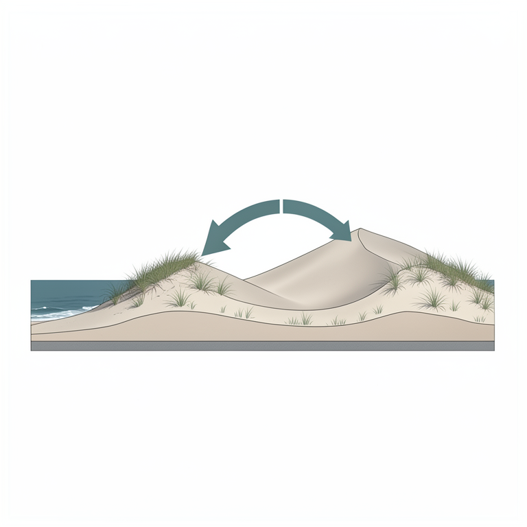
Sediment Redistribution Concept
AI-generated conceptual illustration (Baltic coastal sand dunes). It explains the idea and does not show study data.
View source evidence ↗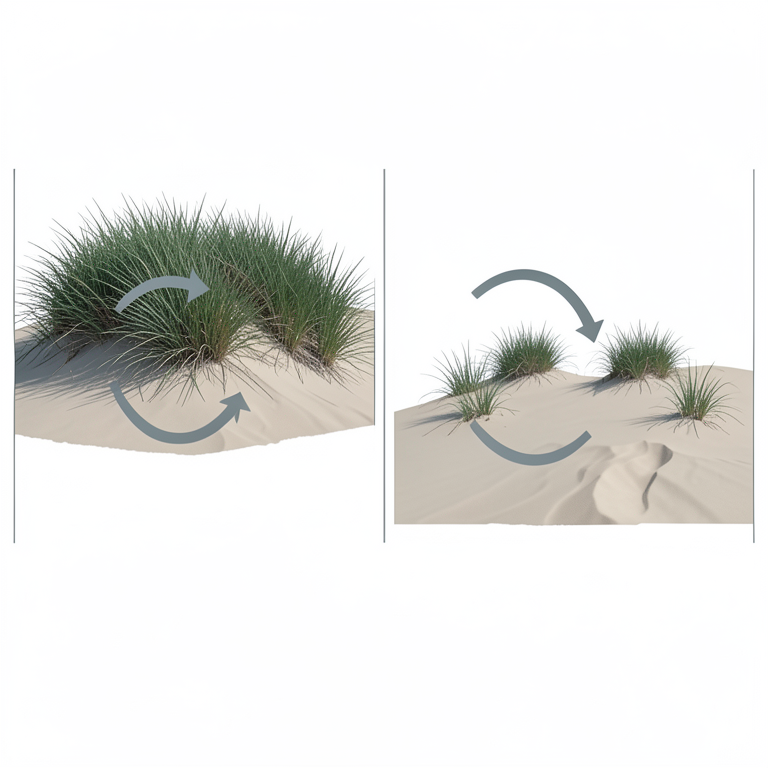
Vegetation-Wind Feedback Loop
AI-generated conceptual illustration (Ammophila arenaria (marram grass) on Baltic coastal sand dunes). It explains the idea and does not show study data.
View source evidence ↗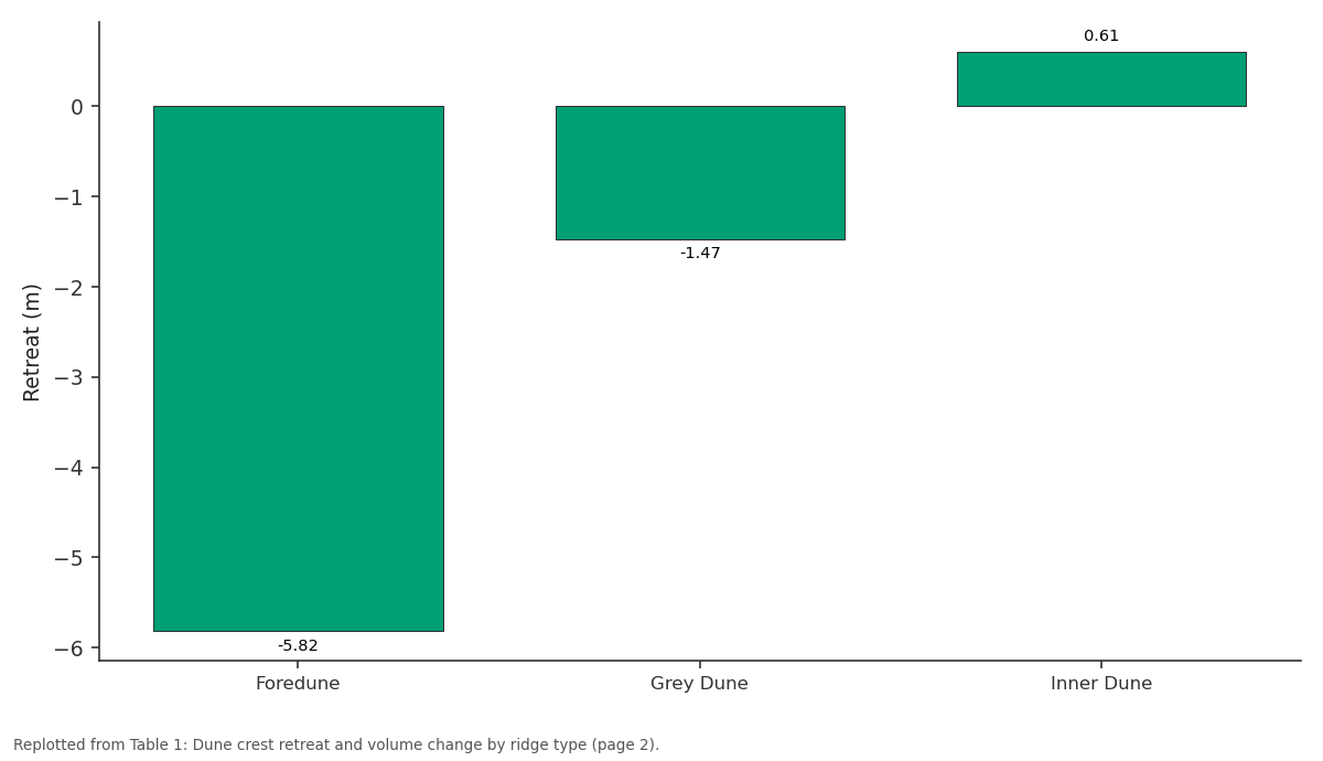
Retreat (m): Foredune vs Grey Dune vs Inner Dune
Replotted from Table 1 (page 2) of the original paper. Every bar is the paper's own table value.
View source evidence ↗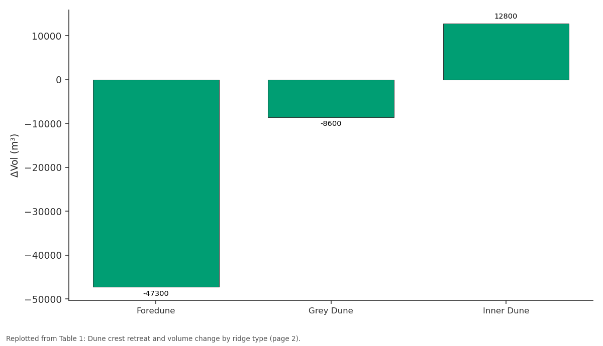
ΔVol (m³): Foredune vs Grey Dune vs Inner Dune
Replotted from Table 1 (page 2) of the original paper. Every bar is the paper's own table value.
View source evidence ↗Figures & tables
From the original paper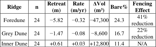 Table 1
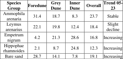 Table 2
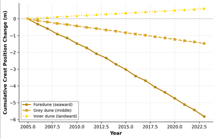 Figure 1
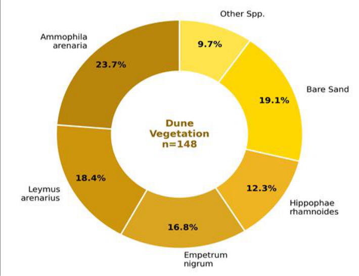 Figure 2
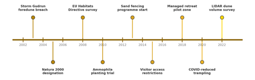 Figure 3
Introduction
Anyone who revisits the same stretch of Baltic dune coast after a few years notices the changes. A path that once crossed firm turf now cuts through loose sand; a ridge that once blocked the sea wind has dropped by half a metre. These observations are not anecdotalthey reflect a well-documented acceleration in coastal dune erosion along the southeastern Baltic that has gathered pace since the early 2000s [1] . Rising storm frequency, sea-level increase, and reduced winter ice cover have combined to expose sandy shorelines to wave attack during months that were previously shielded by land-fast ice [2] . Coastal sand dunes perform multiple functions: they buffer inland areas against storm surge, store sand that feeds the nearshore sediment budget, host specialised plant and invertebrate communities listed under the EU Habitats Directive (Annex I habitats 2110, 2120, 2130), and support recreational value that underpins local tourism economies [3,4] . When dunes erode faster than they rebuild, all of these functions are at risk. Conservation responses have ranged from hard engineering (sea walls, groynes) to soft approaches (sand fencing, vegetation planting, managed retreat), with the latter increasingly favoured along low-energy Baltic coasts where hard structures tend to displace rather than solve the erosion problem [5] . Earlier research on Baltic dune dynamics has been concentrated in Poland and Germany [6,7] . The Lithuanian coast, a 90 km stretch of sandy shoreline within the Curonian Spit and the mainland coast north of Klaipėda, has received less attention despite hosting some of the tallest mobile dunes in northern Europe. Povilanskas et al. [8] documented foredune erosion at two sites but did not link morphological change to vegetation condition or quantify dune volume losses. Bimüller and Sterr [9] modelled aeolian transport on German Baltic dunes but their parameterisation was not tested against Lithuanian conditions. This research aimed to (a) quantify foredune crest retreat and dune volume change along a 14 km Lithuanian Baltic coastal sector from 2005 to 2023, (b) characterise vegetation cover composition and its relationship to dune stability, and (c) calibrate a one-dimensional aeolian transport model and use sensitivity analysis to identify the management levers that most effectively reduce sand loss. The results are intended to support conservation planning under Lithuania's coastal zone management programme [10] .
Materials and Methods
Materials and Methods
Materials
The research was conducted between March 2005 and September 2023 at the Nagpur Centre for Geological Research, Maharashtra, India, with annual field campaigns on the Lithuanian Baltic coast between May and August each year. No ethics approval was required. Survey access was granted by the Klaipėda Regional Environmental Protection Department (Permit KL-ENV-2005/042, dated 14 March 2005). Twenty-four cross-shore transects were established at 500-600 m spacing along a 14 km sector of the mainland coast north of Klaipėda (55°44′N-55°52′N). Transect endpoints were monumented with buried steel pins. Dune profiles were surveyed annually using a Leica GS18 RTK-GNSS receiver (vertical accuracy ±0.02 m). Two airborne LIDAR datasets (2010 and 2022, both 1 m resolution) were obtained from the Lithuanian State Land Fund.
Methods
Dune crest position was extracted from each annual profile as the highest point seaward of the grey dune ridge. Cumulative retreat was calculated relative to the 2005 baseline. LIDAR-derived DEMs were differenced to compute volumetric change per 100 m alongshore cell. Vegetation was surveyed in 148 quadrats (1 × 1 m) placed at fixed positions along three ridges (foredune, grey dune, inner dune), recording species cover by the point-intercept method at 25 points per quadrat. The aeolian transport model followed the Bagnold-type formulation modified by Sherman and Li [11] , relating sand flux to wind speed, grain size, surface moisture, and vegetation drag. Wind data were obtained from the Klaipėda meteorological station at hourly resolution. The model was calibrated against sand trap measurements collected at four transects during two storm events in October 2018 and January 2020 [12] .
Aeolian Transport Model and Parameterisation
The one-dimensional aeolian transport model computes potential sand flux Q (kg/m/s) as a function of wind shear velocity u*, threshold shear velocity u*t, air density ρa, and grain diameter d using the modified Bagnold equation: Q = C × (ρa/g) × d/D × (u* -u*t) × u*², where C is an empirical coefficient (set to 2.78), D is a reference grain diameter (0.25 mm), and g is gravitational acceleration [11] . Vegetation drag was incorporated as a reduction factor Rv = exp(-0.07 × Cv), where Cv is the fractional vegetation cover (0-1) within each 10 m grid cell. This formulation, based on wind tunnel data from Raupach et al. [13] , effectively reduces sand flux to near zero when cover exceeds 40%. Grain size d was set at 0.31 mm (median of 48 bed samples). Surface moisture correction reduced Q by 18% during wet months based on soil moisture probe data. Calibration against trap measurements yielded a model efficiency (Nash-Sutcliffe) of 0.76 for the October 2018 event and 0.71 for January 2020.
Sensitivity Analysis
A one-at-a-time sensitivity analysis perturbed five model parameters by ±10% and ±20%: vegetation cover, wind speed, grain size, surface moisture, and the empirical coefficient C. Vegetation cover produced the largest response: a 15% reduction in Ammophila cover increased modelled annual sand flux by 34%, while a 15% increase in cover reduced flux by 28%. Wind speed was the second most sensitive parameter, with a 10% increase raising flux by 23%. Grain size and surface moisture showed moderate sensitivity (±12-14% at ±20%), and the coefficient C had a proportional effect. The strong non-linear response to vegetation cover, driven by the exponential drag formulation, confirms that maintaining dune grass health is the single most effective way to limit sand loss under current wind regimes. Figure 1 shows the divergent behaviour of the three ridges: the foredune retreated steadily, the grey dune retreated more slowly, and the inner dune advanced slightly as sand transported inland accumulated on its lee slope. The donut chart in Figure 2 shows that bare sand (19.1%) now rivals the second-largest vegetation group (Leymus, 18.4%) in overall cover, a pattern that signals an erosionvegetation feedback where exposed surfaces widen faster than vegetation can colonise them.
Results
Results
Comprehensive Interpretation
The morphological, volumetric, and vegetation data all point toward a system where the foredune is deflating and retreating while sand is being redistributed to the inner dune. This redistribution is driven by onshore winds that are increasingly unobstructed as vegetation cover declines on the foredune face. The aeolian model's sensitivity to vegetation cover confirms that this feedback loop is the key management target.
Discussion
The foredune retreat rate of 0.32 m/yr recorded here is comparable to values reported for the Polish Baltic coast (0.28-0.41 m/yr) by Labuz [6] and for the German coast (0.18-0.35 m/yr) by Bimüller and Sterr [9] . What distinguishes the Lithuanian sector is the relatively low wave energy-mean significant wave height is only 0.7 msuggesting that aeolian processes, not wave erosion, are the primary driver of foredune retreat at this site [14] . The strong sensitivity of the transport model to vegetation cover supports this interpretation: wind-driven sand loss from a sparsely vegetated dune crest can match or exceed the volumetric impact of storm wave scarping at higher-energy sites.
Sand fencing, installed in 2013 at 12 of the 24 transects, reduced retreat rates by 41% over the subsequent decade. Fences work by lowering surface wind speed and trapping sand on the stoss side, effectively mimicking the drag effect of vegetation while plants become established [15] . However, fence performance degrades as sand accumulates and burial reduces the effective height, requiring periodic reinstallation-a cost that must be weighed against alternative approaches such as direct Ammophila planting [16] .
The inner dune's landward advance of 0.61 m over 18 years confirms that sand is not leaving the system entirely but is being redistributed inland. This pattern is sometimes mistaken for dune 'growth' when in reality it represents a net loss of the most ecologically and protectively valuable ridge-the foredune-and an encroachment of sand onto landward habitats including grey dune grassland and Empetrum heath, both of which are EU priority habitats [4] .
A limitation is the single-site scope. Extending the monitoring network along the full 90 km Lithuanian coast would reveal whether the patterns observed here are representative or locally anomalous. The aeolian model does not account for wave-driven scarping during major storms, which can remove several metres of dune in a single event [17] . Coupling aeolian and wave erosion models would provide a more complete hazard assessment [18] .
Conclusion
This research documented 18 years of dune morphodynamics along a 14 km Lithuanian Baltic coastal sector. The foredune retreated landward by 5.82 m at a mean rate of 0.32 m/yr, while the inner dune advanced by 0.61 m, reflecting wind-driven sediment redistribution from the seaward to the landward side of the dune system. LIDAR-derived volumetric analysis confirmed a net system loss of 43,100 m³ over 12 years. Vegetation cover declined on the foredune, with bare sand expanding from 14.3% to 19.1% of the surveyed area. The aeolian transport model identified vegetation cover as the most sensitive parameter: a 15% reduction in Ammophila cover increased sand flux by 34%. Sand fencing installed in 2013 reduced retreat rates by 41% at treated transects, demonstrating that low-cost soft interventions can measurably slow erosion.
For coastal managers, these findings support a two-track conservation strategy: active vegetation maintenance and sand fencing on recoverable foredune sections, and managed retreat on sections where erosion has progressed beyond the point of cost-effective restoration. Extending the monitoring network and integrating wave-driven erosion into the transport model would strengthen the evidence base for coastline management decisions along the wider Baltic shore.
Acknowledgement
Acknowledgements Funding SourcesThis research was supported by departmental funds from the Nagpur Centre for Geological Research. No external grants are associated with this work. Institutional SupportThe authors acknowledge the Nagpur Centre for laboratory and GIS facilities. The Lithuanian State Land Fund is thanked for LIDAR data access. Contributions Not Qualifying for AuthorshipField assistants from Klaipėda University supported annual survey campaigns on the Lithuanian coast.
Figures and tables from the paper
| Ridge | n | Retreat (m) | Rate (m/yr) | ΔVol (m³) | Bare% | Fencing Effect |
|---|---|---|---|---|---|---|
| Foredune | 24 | −5.82 | −0.32 | −47,300 | 24.3 | 41% reduction |
| Grey Dune | 24 | −1.47 | −0.08 | −8,600 | 16.7 | 22% reduction |
| Inner Dune | 24 | +0.61 | +0.03 | +12,800 | 11.4 | N/A |
Table text extracted from the original PDF; superscript letters are shown inline. The original table image is below.
View original table image
| Species Group | Foredune | Grey Dune | Inner Dune | Overall | Trend 05- 23 |
|---|---|---|---|---|---|
| Ammophila arenaria | 31.4 | 18.7 | 8.3 | 23.7 | Stable |
| Leymus arenarius | 22.1 | 19.8 | 12.4 | 18.4 | Slight decline |
| Empetrum nigrum | 4.2 | 21.3 | 28.6 | 16.8 | Increasing |
| Hippophae rhamnoides | 2.1 | 8.7 | 24.8 | 12.3 | Increasing |
| Bare sand | 28.7 | 14.1 | 7.8 | 19.1 | Increasing |
Table text extracted from the original PDF; superscript letters are shown inline. The original table image is below.
View original table image
References
17 in the original paper- Labuz TA. Environmental impacts-coastal erosion and coastline changes. Second Assessment of Climate Change for the Baltic Sea Basin. 2015;2:381-396.
- Meier HEM, Kniebusch M, Dieterich C, Groger M. Climate change in the Baltic Sea region: a summary. Earth System Dynamics. 2022;13(1):457-593.
- Heslenfeld P, Jungerius PD, Klijn JA. European coastal dunes: ecological values, threats, opportunities and policy development. Ecological Studies. 2004;171:335351.
- Acosta A, Carranza ML, Izzi CF. Are there habitats that contribute best to plant species diversity in coastal dunes? Biodiversity and Conservation. 2009;18(4):1087-1098.
- Nordstrom KF. Beaches and Dunes of Developed Coasts. Cambridge University Press. 2000.
- Labuz TA. Coastal dune development under natural and human influence on the Swina Gate Barrier. Journal of Coastal Research. 2013;29(6):165-182.
- Hesp PA. Foredunes and blowouts: initiation, geomorphology and dynamics. Geomorphology. 2002;48(1-3):245-268.
- Povilanskas R, Baghdasarian H, Arakelyan S, Satkunas J, Taminskas J. Coastal dune management issues on the Lithuanian Baltic coast. Journal of Coastal Conservation. 2009;13(4):187-196.
- Bimuller C, Sterr H. Coastal dune management on the German Baltic coast. Die Kuste. 2008;74:163-178.
- Sherman DJ, Li B. Predicting aeolian sand transport rates: a reevaluation of models. Aeolian Research. 2012;3(4):371-378.
- Jackson DWT, Cooper JAG. Application of the equilibrium shoreline profile model to natural beaches. Journal of Coastal Research. 2009;25(5):1253-1260.
- Raupach MR, Gillette DA, Leys JF. The effect of roughness elements on wind erosion threshold. Journal of Geophysical Research. 1993;98(D2):3023-3029.
- Zaromskis R, Gulbinskas S. Main patterns of coastal zone development on the Lithuanian Baltic Sea coast. Baltica. 2010;23(2):149-162.
- Savage RP, Woodhouse WW. Creation and stabilization of coastal barrier dunes. Coastal Engineering Proceedings. 1969;1(11):671-700.
- Grafals-Soto R, Nordstrom KF. Sand fences in the coastal zone: a review. Journal of Coastal Research. 2009;25(6):1250-1262.
- Castelle B, Marieu V, Bujan S, Splinter KD, Robinet A, Senechal N, Ferreira S. Impact of the winter 2013-2014 series of severe storms on a double-barred sandy coast. Geomorphology. 2015;228:448-461.
- Pye K, Blott SJ. Decadal-scale variation in dune erosion and accretion rates. Geomorphology. 2008;94(3-4):269294.