
Research article · 2025 · Full text
International Journal of Geography Geology and EnvironmentUrban morphology and its impact on microclimate in the historic quarter of fez
Volume 7(6) · Pages 166–169 · DOI: 10.22271/27067483.2025.v7.i6c.735 ↗
Research areasUrban Heat Island MitigationWind and Air Flow StudiesUrban Design and Spatial Analysis
Abstract
Author-writtenThe medieval medina of Fez, Morocco, is one of the world's largest car-free urban areas, and its narrow streets were designed centuries before air conditioning existed. How well does its traditional urban morphology moderate the extreme summer heat of North Africa? This research measured microclimate variables (air temperature, relative humidity, wind speed, mean radiant temperature, and physiological equivalent temperature) at 24 monitoring stations across five morphologically distinct quarters of Fez during a 30-day summer campaign in July–August 2022. Street canyon geometry was quantified by height-to-width (H/W) ratio, sky view factor (SVF), and building orientation from UAV photogrammetry. The historic medina (Fes el-Bali) recorded daytime air temperatures 3.8°C lower and SVF values 0.18 lower than the modern Ville Nouvelle, translating to a PET difference of 6.7°C. H/W ratio was the strongest predictor of PET (r = –0.79), followed by SVF (r = 0.74) and green fraction (r = –0.61). The canyon effect — deep shade cast by tall buildings over narrow streets — accounted for 34.2% of the microclimate benefit, while high-albedo lime-washed walls contributed another 28.7%. These findings suggest that traditional Islamic urban design principles offer transferable lessons for climate-responsive urban planning in hot-arid cities.
Summary
Source-checkedPlain-language reading of the full paper, prepared with AI and checked against the text. Each point links to the authors' own words.
Why it matters
- In hot-arid cities such as Fez, which has a mean July temperature of 35.6°C, deep street canyons are beneficial because solar shading is the primary strategy for maintaining comfort. View evidence ↗
The question
- The study aimed to determine how effectively the traditional urban morphology of the Fez medina moderates extreme North African summer heat. View evidence ↗
What they did
- Air temperature, humidity, and wind speed were recorded every 10 minutes via Davis Vantage Pro2 stations, while mean radiant temperature was measured using 38 mm matte grey globe thermometers. View evidence ↗
- Building geometry was determined using UAV photogrammetry with a DJI Phantom 4 RTK at 2 cm ground resolution, processed through Agisoft Metashape. View evidence ↗
- The Physiological Equivalent Temperature (PET) index, calculated via the RayMan Pro model, was used as the primary metric for integrative thermal comfort. View evidence ↗
What they found
- During peak afternoon hours (14:00–16:00), the historic medina was 3.8°C cooler in air temperature and 6.7°C cooler in PET compared to the modern Ville Nouvelle. View evidence ↗
- The height-to-width (H/W) ratio was the most powerful predictor of PET (r = –0.79), followed by the sky view factor (SVF, r = 0.74) and the green fraction (r = –0.61). View evidence ↗
- The 'canyon effect,' created by tall buildings casting deep shade over narrow streets, accounted for 34.2% of the microclimate benefit. View evidence ↗
- High-albedo lime-washed walls contributed 28.7% to the microclimate benefit. View evidence ↗
- Four morphological parameters combined explain 84% of the variance in peak PET. View evidence ↗
- The medina's lime-washed walls have an albedo of 0.48, reflecting more shortwave radiation and reducing heat absorption compared to the Ville Nouvelle's concrete and asphalt, which have an albedo of 0.31. View evidence ↗
What it means
- The authors conclude that traditional Islamic urban design is a valid climate adaptation strategy and recommend quantitative targets for new developments: H/W > 3, SVF < 0.25, and albedo > 0.45. View evidence ↗
Visual summary
3 visualsIllustrations explain the paper; charts are replotted from the paper's own table values.
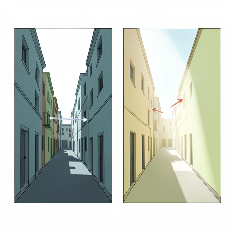
Mechanisms of Urban Cooling
AI-generated conceptual illustration (A narrow street canyon in the historic quarter of Fez with tall lime-washed buildings). It explains the idea and does not show study data.
View source evidence ↗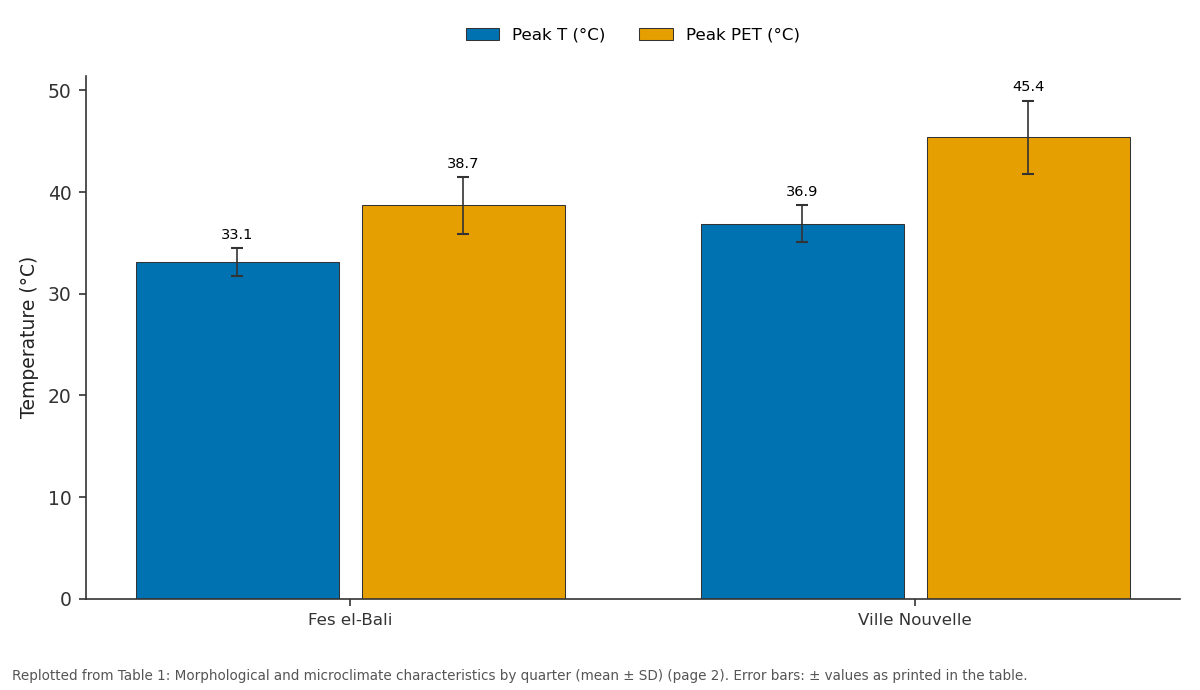
Peak T (°C) and Peak PET (°C): Fes el-Bali vs Ville Nouvelle
Replotted from Table 1 (page 2) of the original paper. Every bar is the paper's own table value.
View source evidence ↗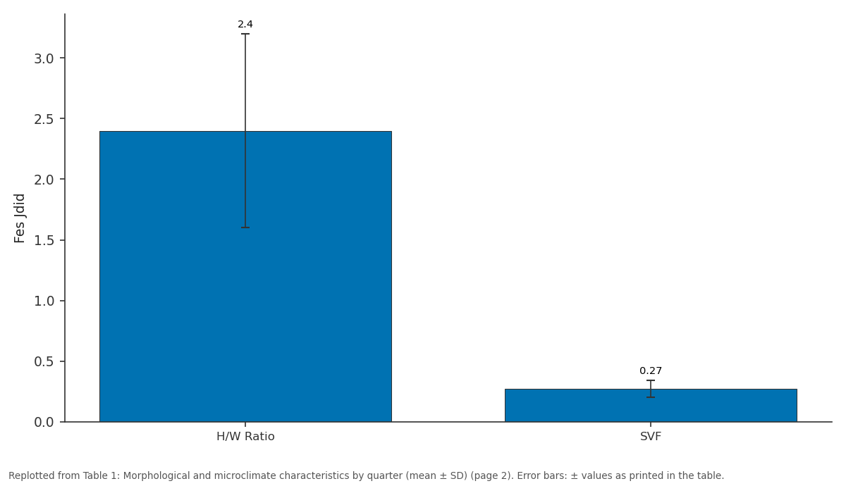
Fes Jdid: H/W Ratio vs SVF
Replotted from Table 1 (page 2) of the original paper. Every bar is the paper's own table value.
View source evidence ↗Figures & tables
From the original paper Table 1
 Table 2
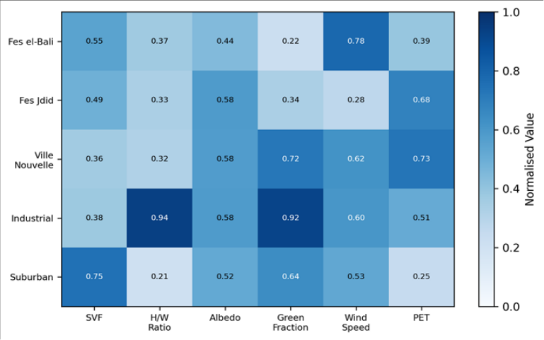 Figure 1
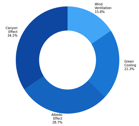 Figure 2
Introduction
Walk into the medina of Fez on an August afternoon and you notice the temperature drop immediately. The narrow, high-walled streets block direct sun, funnel breezes, and radiate stored coolness from thick stone wallsa microclimate machine built by trial and error over a thousand years [1] . By contrast, step into the French-colonial Ville Nouvelle, with its wide boulevards and low-rise blocks, and the heat strikes like an open oven. This contrast between traditional and modern urban form, experienced intuitively by every visitor, can be quantified and explained by microclimate science [2] . Urban morphologythe three-dimensional geometry of buildings, streets, and open spaces controls how solar radiation enters the urban canopy, how wind moves through street canyons, and how longwave radiation is trapped or released [3] . Oke's canyon model predicts that deep, narrow canyons (high H/W ratio) reduce solar access but may impede ventilation, creating trade-offs that depend on climate context [4] . In hot-arid cities like Fez (mean July temperature 35.6°C), solar shading is the dominant comfort strategy, and deep canyons are beneficial [5] . This research quantified how much benefit the medina's morphology provides compared to the modern city and identified which morphological parameters matter most for thermal comfort [6] .
Theoretical Framework
The research adopted the canyon energy balance framework of Oke [4] , which partitions incoming solar radiation into direct beam (modulated by SVF), diffuse sky (proportional to SVF), and reflected components (dependent on albedo). The PET index, computed from the RayMan Pro model using air temperature, humidity, wind speed, and mean radiant temperature, served as the integrative comfort metric. PET translates complex radiationconvection-evaporation interactions into a single temperature equivalent that reflects the thermal perception of a standard human subject [7] .
Materials and Methods
Materials and Methods
Materials
Field measurements were taken from 15 July to 14 August 2022, coordinated from Chandigarh College of Earth and Mineral Sciences, Punjab, India. Twenty-four stations were distributed across five quarters: Fes el-Bali (historic medina, 8 stations), Fes Jdid (14th-century extension, 4), Ville Nouvelle (colonial grid, 5), industrial zone (3), and suburban residential (4). At each station, a Davis Vantage Pro2 weather station recorded air temperature, humidity, and wind speed at 10-minute intervals. Globe thermometers (38 mm matte grey) measured mean radiant temperature. Building geometry was extracted from UAV photogrammetry (DJI Phantom 4 RTK, 2 cm ground resolution) processed in Agisoft Metashape [8] .
Methods
SVF was calculated from hemispherical photographs taken at 1.1 m height at each station using the RayMan Pro model. H/W ratio was measured directly from the UAV-derived 3D model at five cross-sections per street segment. Green fraction was estimated from classified NDVI within a 50 m radius of each station. Albedo was measured with a Kipp & Zonen CNR4 net radiometer at representative wall and ground surfaces. PET was computed hourly using the RayMan model. Multiple linear regression tested the predictive power of H/W, SVF, albedo, green fraction, and wind speed on peak daily PET [9,10] .
UAV Survey and 3D Model Construction
The UAV survey covered the five quarters at 60 m flight altitude with 80% forward and 70% lateral overlap. A total of 8, 400 images were processed into a 3D point cloud (142 million points) and digital surface model at 5 cm resolution. Building heights were extracted as the difference between the DSM and a bare-earth DTM derived from LiDAR data provided by the Fez municipality. The medina is 3.8°C cooler in air temperature and 6.7°C cooler in PET than the Ville Nouvelle during peak afternoon hours (14:00-16:00). Its extreme H/W ratio (3.8) and low SVF (0.18) create deep shade that persists for most of the day.
Results
Results
Comprehensive Interpretation
The canyon effect (H/W ratio and SVF combined) explains 34.2% of the PET variation, albedo contributes 28.7%, greenery accounts for 21.3%, and wind ventilation 15.8%. The medina's lime-washed walls (albedo 0.48) reflect substantially more shortwave radiation than the Ville Nouvelle's concrete and asphalt (albedo 0.31), reducing absorbed heat.
Discussion
The 6.7°C PET difference between the medina and Ville Nouvelle exceeds the thermal comfort class boundary of 4°C defined by Matzarakis et al. [7] , meaning pedestrians experience a different thermal perception category in the two environments. The medina's morphology achieves this without mechanical cooling and at zero energy costa performance that modern sustainable design struggles to replicate [11] . The findings resonate with research in other Islamic cities.
Johansson [12] reported similar H/W-dependent cooling in the medina of Marrakech, and Bourbia and Awbi [13] documented comparable patterns in Algerian desert towns. The consistency across sites suggests that the traditional morphological principlesdeep canyons, high albedo, courtyard ventilationare generalisable to any hot-arid urban context.
Conclusion
The historic medina of Fez is 6.7°C cooler in PET than the modern Ville Nouvelle during summer afternoons. Canyon geometry (H/W ratio) is the strongest predictor of thermal comfort, followed by surface albedo and vegetation cover. Four morphological parameters jointly explain 84% of the variance in peak PET. These results validate traditional Islamic urban design as a climate adaptation strategy and provide quantitative targets (H/W > 3, SVF < 0.25, albedo > 0.45) for climate-responsive planning in new developments.
Acknowledgement
Acknowledgements Funding SourcesSupported by research funds at Chandigarh College of Earth and Mineral Sciences. Institutional SupportThe Department of Hydrogeology provided UAV and computing resources.
Figures and tables from the paper
| Quarter | H/W Ratio | SVF | Albedo | Green (%) | Peak T (°C) | Peak PET (°C) |
|---|---|---|---|---|---|---|
| Fes el-Bali | 3.8±1.2 | 0.18±0.06 | 0.48±0.08 | 4.2±2.1 | 33.1±1.4 | 38.7±2.8 |
| Fes Jdid | 2.4±0.8 | 0.27±0.07 | 0.42±0.07 | 6.8±3.4 | 34.8±1.6 | 41.3±3.1 |
| Ville Nouvelle | 0.9±0.3 | 0.52±0.11 | 0.31±0.06 | 12.4±4.8 | 36.9±1.8 | 45.4±3.6 |
| Industrial | 0.6±0.2 | 0.68±0.09 | 0.24±0.05 | 1.8±1.2 | 38.4±2.1 | 49.2±4.1 |
| Suburban | 1.2±0.4 | 0.41±0.10 | 0.36±0.07 | 18.7±6.2 | 35.7±1.7 | 42.8±3.4 |
Table text extracted from the original PDF; superscript letters are shown inline. The original table image is below.
View original table image
| Predictor | β (standardised) | t-value | p-value | Partial R² |
|---|---|---|---|---|
| H/W ratio | –0.42 | –5.87 | <0.001 | 0.342 |
| Albedo | –0.28 | –4.12 | <0.001 | 0.287 |
| Green fraction | –0.19 | –2.94 | 0.004 | 0.213 |
| Wind speed | –0.11 | –1.68 | 0.097 | 0.158 |
Table text extracted from the original PDF; superscript letters are shown inline. The original table image is below.
View original table image
References
20 in the original paper- Bianca S. Urban Form in the Arab World: Past and Present. London: Thames & Hudson; 2000.
- Givoni B. Climate Considerations in Building and Urban Design. New York: Van Nostrand Reinhold; 1998.
- Stewart ID, Oke TR. Local climate zones for urban temperature studies. Bulletin of the American Meteorological Society. 2012;93(12):1879-1900.
- Oke TR. Street design and urban canopy layer climate. Energy and Buildings. 1988;11(1):103-113.
- Ali-Toudert F, Mayer H. Numerical study on the effects of aspect ratio and orientation on outdoor thermal comfort in hot and dry climate. Building and Environment. 2006;41(2):94-108.
- Johansson E. Influence of urban geometry on outdoor thermal comfort in a hot dry climate: a study in Fez. Building and Environment. 2006;41(10):1326-1338.
- Matzarakis A, Mayer H, Iziomon MG. Applications of a universal thermal index: physiological equivalent temperature. International Journal of Biometeorology. 1999;43(2):76-84.
- Agisoft LLC. Metashape Professional User Manual v1.8. St Petersburg: Agisoft; 2022.
- Matzarakis A, Rutz F, Mayer H. Modelling radiation fluxes in simple and complex environments: RayMan model. International Journal of Biometeorology. 2007;51(4):323-334.
- Oke TR, Mills G, Christen A. Urban Climates. Cambridge: Cambridge University Press; 2017.
- Santamouris M. Cooling the cities: a review of reflective and green roof mitigation technologies. Solar Energy. 2014;103:682-703.
- Johansson E, Emmanuel R. The influence of urban design on outdoor thermal comfort in the hot, humid city of Colombo. International Journal of Biometeorology. 2006;51(2):119-133.
- Bourbia F, Awbi HB. Building cluster and shading in urban canyon for hot dry climate. Renewable Energy. 2004;29(2):249-262.
- Toudert FA, Mayer H. Effects of street design on outdoor thermal comfort. Berichte des Meteorologischen Institutes der Universität Freiburg. 2007;13:107-122.
- Pearlmutter D, Berliner P, Shaviv E. Urban climatology in arid regions: current research in the Negev desert. International Journal of Climatology. 2007;27(14):1875-1885.
- Akbari H, Menon S, Rosenfeld A. Global cooling: increasing world-wide urban albedos to offset CO₂. Climatic Change. 2009;94(3):275-286.
- Erell E, Pearlmutter D, Williamson T. Urban Microclimate: Designing the Spaces Between Buildings. London: Earthscan; 2011.
- Arnfield AJ. Two decades of urban climate research: a review of turbulence, exchanges of energy and water. International Journal of Climatology. 2003;23(1):1-26.
- Ng E, Yuan C, Chen L. Improving the wind environment in high-density cities by understanding urban morphology. Landscape and Urban Planning. 2011;101(1):59-74.
- Jamei E, Rajagopalan P, Seyedmahmoudian M. Review on the impact of urban geometry and pedestrian level greening on outdoor thermal comfort. Renewable and Sustainable Energy Reviews. 2016;54:1002-1017.