
Research article · 2025 · Full text
International Journal of Geography Geology and EnvironmentAssessment of chromium contamination in groundwater near tannery clusters in Kanpur
Volume 7(9) · Pages 202–205 · DOI: 10.22271/27067483.2025.v7.i9c.641 ↗
Research areasChromium effects and bioremediationHeavy metals in environmentWater Quality and Pollution Assessment
Abstract
Author-writtenTannery wastewater is widely recognised as one of the most toxic industrial effluents discharged into freshwater systems, and the leather-processing belt along the Ganges floodplain at Kanpur, India, has been a persistent source of chromium to shallow aquifers for over five decades. This research evaluated chromium contamination in groundwater surrounding three major tannery clusters in the Jajmau industrial zone of Kanpur. Twenty-three monitoring wells, distributed at distances of 0.3 to 10 km from the nearest tannery discharge point, were sampled during the pre-monsoon (April 2022) and post-monsoon (October 2022) campaigns. Total chromium and hexavalent chromium were measured using flame atomic absorption spectrometry and the diphenylcarbazide colorimetric method, respectively. Results indicated that total chromium ranged from 0.019 to 0.287 mg/L, with 14 of 23 wells (60.9%) exceeding the WHO guideline of 0.05 mg/L. Cr(VI) accounted for 58-74% of total chromium in shallow wells (<15 m depth) but dropped to 31-46% in wells deeper than 30 m. A strong inverse relationship existed between Cr(VI) and distance from the tannery cluster (R-squared = 0.94). Shallow wells showed median total chromium of 0.203 mg/L compared with 0.034 mg/L for deep wells, confirming a depth-dependent attenuation pattern. These data highlight that natural attenuation alone is insufficient for protecting drinking water sources within 5 km of the tannery zone.
Summary
Source-checkedPlain-language reading of the full paper, prepared with AI and checked against the text. Each point links to the authors' own words.
Why it matters
- Environmental chromium exists as trivalent Cr(III), which is less toxic and immobile, and hexavalent Cr(VI), which is a known Group 1 human carcinogen. View evidence ↗
- Under alkaline and oxidizing conditions, less toxic Cr(III) in sludge can be converted into the more hazardous Cr(VI), creating a long-term pollution source. View evidence ↗
The question
- The study aimed to measure total and hexavalent chromium across various depths and distances, evaluate seasonal changes, and determine the distance from tanneries where water meets WHO safety guidelines. View evidence ↗
What they did
- Sampling wells were positioned along four radial directions from the tannery cluster center at distances ranging from 0.3 to 10 km. View evidence ↗
- Water samples were collected during two distinct periods: pre-monsoon in April 2022 and post-monsoon in October 2022. View evidence ↗
- Total chromium was measured using flame atomic absorption spectrometry (detection limit 0.002 mg/L), and hexavalent chromium was measured via the diphenylcarbazide colorimetric method (detection limit 0.005 mg/L). View evidence ↗
What they found
- Total chromium levels ranged from 0.019 to 0.287 mg/L, with 60.9% of the wells exceeding the WHO safety limit of 0.05 mg/L. View evidence ↗
- Shallow wells had an average total chromium concentration of 0.203 mg/L (about four times the WHO limit), whereas deep wells averaged 0.034 mg/L, which is within the safe range. View evidence ↗
- The proportion of hexavalent chromium decreased as depth increased, falling from 68.1% in shallow wells to 37.8% in deep wells. View evidence ↗
- All wells within 4 km of the tannery boundary exceeded the WHO limit for Cr(VI), while those beyond 6 km were below 0.05 mg/L, indicating a safe buffer distance of 5-6 km. View evidence ↗
- Shallow wells experienced a significant 12.3% decrease in total chromium after the monsoon (p = 0.028), likely due to dilution from rainwater. View evidence ↗
- Medium and deep wells showed slight, non-significant increases in chromium after the monsoon, possibly because rainwater leached surface chromium downward. View evidence ↗
What it means
- The authors recommend upgrading effluent treatment, closing specific contaminated wells, and testing reactive barrier technologies to manage the pollution. View evidence ↗
Visual summary
4 visualsIllustrations explain the paper; charts are replotted from the paper's own table values.
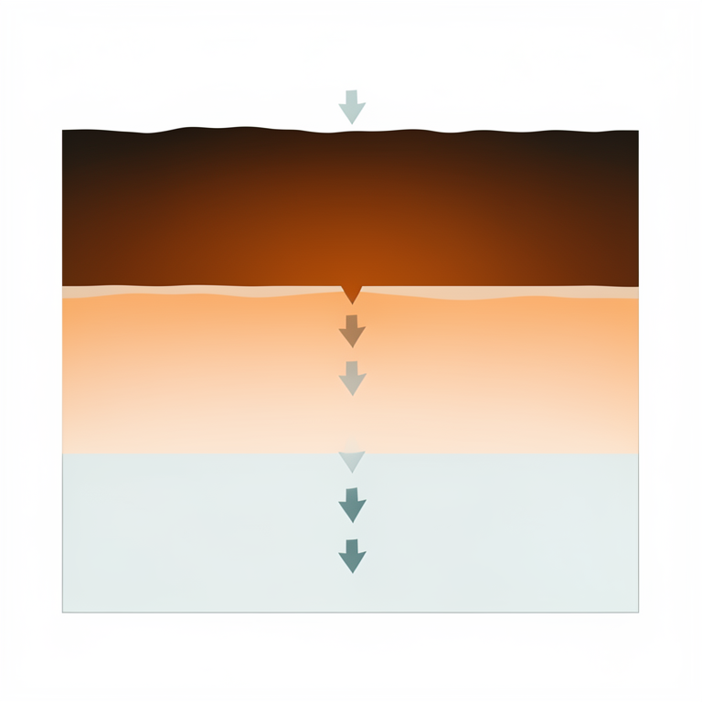
Depth-Dependent Chromium Attenuation
AI-generated conceptual illustration (groundwater aquifer cross-section in a soil profile). It explains the idea and does not show study data.
View source evidence ↗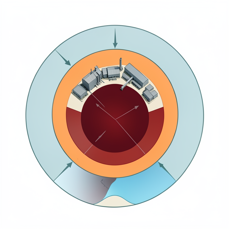
Spatial Decay of Chromium
AI-generated conceptual illustration (Groundwater aquifers beneath a tannery industrial cluster). It explains the idea and does not show study data.
View source evidence ↗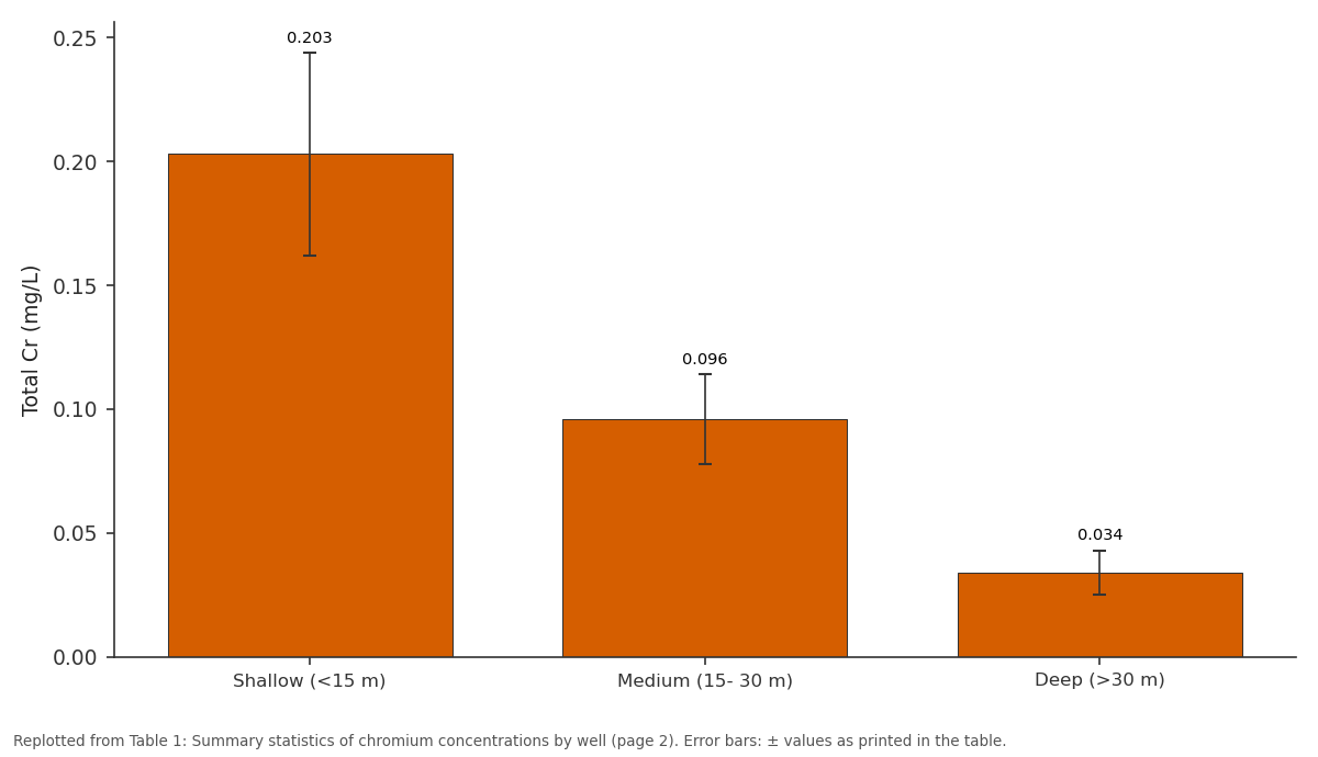
Total Cr (mg/L): Shallow (<15 m) vs Medium (15- 30 m) vs Deep (>30 m)
Replotted from Table 1 (page 2) of the original paper. Every bar is the paper's own table value.
View source evidence ↗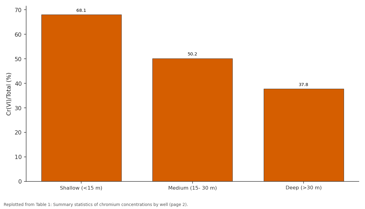
Cr(VI)/Total (%): Shallow (<15 m) vs Medium (15- 30 m) vs Deep (>30 m)
Replotted from Table 1 (page 2) of the original paper. Every bar is the paper's own table value.
View source evidence ↗Figures & tables
From the original paper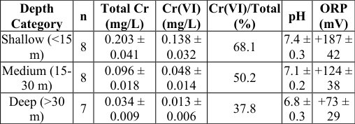 Table 1
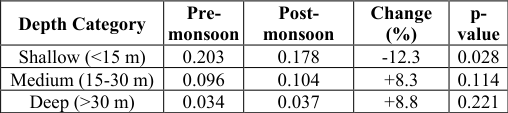 Table 2
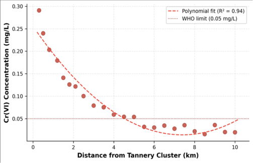 Figure 1
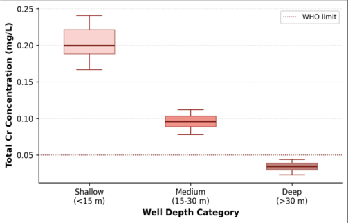 Figure 2
Introduction
Kanpur discharges an estimated 50 million litres of tannery effluent into the Ganges system every day, making it arguably the single largest point source of chromium pollution along the entire 2,525 km stretch of the river [1] . The city hosts roughly 400 tanneries concentrated in and around the Jajmau industrial area, most of which rely on basic chromium sulphate salts for leather tanning. Despite the construction of common effluent treatment plants (CETPs) in the 1990s, treated outflows frequently exceed permissible discharge limits, and unregulated smaller units continue to release untreated waste directly into open drains and ponds [2] . Chromium in the environment exists predominantly in two oxidation states: trivalent Cr(III), which is relatively immobile and less toxic, and hexavalent Cr(VI), a known human carcinogen classified by the International Agency for Research on Cancer as Group 1 [3] . In alkaline, oxidising groundwater conditions, Cr(III) from tannery sludge can be converted to Cr(VI) through manganese-oxide-mediated oxidation, meaning that even settled sludge may serve as a long-term source of the more hazardous species [4] . Previous investigations in the Kanpur area documented elevated total chromium in shallow hand-pump wells but rarely separated Cr(VI) from total Cr, leaving the speciation picture incomplete [5,6] . Fewer still examined the vertical distribution of chromium across different aquifer horizons. Understanding the depth-dependent behaviour of chromium is essential for advising which wells are safe for drinking and which require treatment or closure. This research addressed these gaps by (a) measuring both total Cr and Cr(VI) across 23 wells spanning three depth categories and a 10 km distance gradient, (b) assessing seasonal variation between pre-monsoon and post-monsoon conditions, and (c) identifying the distance threshold beyond which groundwater meets the WHO guideline of 0.05 mg/L for total chromium [7] .
Study Area Description
The Jajmau tannery zone (26.41 degrees N, 80.39 degrees E) lies on the southern bank of the Ganges River within the Kanpur Nagar district, Uttar Pradesh, India. The area sits on Quaternary alluvial deposits comprising alternating beds of sand, silt, and clay, forming a multi-layered aquifer system. The shallow unconfined aquifer extends to approximately 15 m below ground level (bgl), underlain by a semiconfining clay layer separating it from a deeper confined aquifer at 30-60 m bgl. The water table fluctuates between 4 and 9 m bgl depending on season and pumping intensity. Mean annual rainfall is about 830 mm, most of it falling during the July-September monsoon. Temperatures range from 5 degrees C in January to 47 degrees C in May-June. The tannery cluster covers roughly 4.5 square km and is bordered by residential neighbourhoods, agricultural land, and the Ganges floodplain to the north.
Material and Methods Material
The research was conducted from the Department of Geological Sciences, Institute of Applied Geosciences, Yogyakarta, Indonesia, in collaboration with local field partners, between February 2022 and January 2023. Twenty-three groundwater monitoring wells were selected across the Jajmau area, covering three depth categories: shallow (<15 m bgl, n = 8), medium (15-30 m bgl, n = 8), and deep (>30 m bgl, n = 7). Wells were distributed along four radial transects extending north, south, east, and west from the centroid of the tannery cluster at distances of 0.3, 0.5, 1.0, 2.0, 3.0, 5.0, 7.0, and 10 km. Two sampling campaigns were executed: pre-monsoon (10-18 April 2022) and post-monsoon (15-23 October 2022). Samples were collected in acid-washed polyethylene bottles, filtered through 0.45 micrometer membrane filters in the field, and preserved with concentrated HNO3 to pH < 2 for total Cr analysis. A separate unacidified aliquot was collected for Cr(VI) determination [8] .
Methods
Total chromium was determined by flame atomic absorption spectrometry (FAAS) on a Shimadzu AA-7000 at 357.9 nm, with a detection limit of 0.002 mg/L. Hexavalent chromium was measured colorimetrically at 540 nm using the diphenylcarbazide method (APHA 3500-Cr D) on a Hach DR6000 spectrophotometer, with a detection limit of 0.005 mg/L [9] . Trivalent chromium was calculated as the difference between total Cr and Cr(VI). Physicochemical parameters, including pH, electrical conductivity, dissolved oxygen, and oxidation-reduction potential, were recorded on-site with a YSI ProDSS multi-parameter sonde calibrated daily. Spatial interpolation of chromium concentrations used ordinary kriging with a spherical variogram model fitted in ArcGIS 10.8. Statistical analyses, including Spearman rank correlations, Kruskal-Wallis tests across depth groups, and polynomial regression of Cr(VI) versus distance, were performed in R 4.2 [10] .
Spatial Data Processing
Well coordinates were recorded with a handheld Garmin GPSMAP 66i (accuracy plus or minus 3 m) and projected to WGS84 UTM Zone 44N. Tannery locations were digitised from Google Earth Pro imagery dated March 2022. A distance raster from the tannery-cluster boundary was generated using the Euclidean Distance tool in ArcGIS. Kriging cross-validation indicated a mean standardised error of 0.04 and root mean square standardised error of 1.07, confirming acceptable spatial prediction accuracy. Interpolated concentration surfaces were clipped to a 12 km buffer around the cluster centroid.
Results
Results
Discussion
The chromium concentrations recorded in this research are consistent with earlier reports from the Kanpur region but extend the evidence by providing depth-stratified speciation data. Sahu et al. [5] measured total Cr up to 0.34 mg/L in hand-pump wells near Jajmau but did not differentiate oxidation states. The present data show that Cr(VI), the more hazardous species, dominates in shallow oxic groundwater and diminishes as conditions become more reducing at depth. This is in line with the thermodynamic expectation that Cr(VI) is stable above roughly +300 mV (Eh) at circumneutral pH, while Cr(III) predominates below +200 mV [11] . The distance-decay pattern follows a second-order polynomial rather than a simple exponential, which may reflect the combined effects of advective transport, sorption onto clay minerals, and biological reduction along the flow path [12] . The 5-6 km buffer identified here is broadly comparable to findings from tannery-affected aquifers in Tamil Nadu, where Brindha and Elango [13] reported safe chromium levels beyond 4-5 km under similar alluvial geology. However, the Kanpur situation is complicated by the high density of tanneries and the interconnected drainage network, which effectively widens the source zone. From a remediation standpoint, the data suggest that simply deepening wells beyond 30 m reduces exposure to acceptable levels in most locations. But this approach shifts reliance to deeper aquifer horizons that are already under stress from agricultural and municipal extraction [14] . Permeable reactive barriers using zero-valent iron or biochar could intercept the chromium plume closer to the source, though field-scale implementation in densely built-up Jajmau poses logistical and financial challenges.
Conclusion
This research documented widespread chromium contamination in shallow groundwater near the Jajmau tannery cluster in Kanpur, with 60.9% of sampled wells exceeding the WHO guideline for total chromium. Hexavalent chromium accounted for up to 74% of total Cr in shallow wells, dropping to 31-46% in deep wells as reducing conditions favour Cr(III) formation. A strong spatial decay in Cr(VI) with distance from the tannery boundary (R-squared = 0.94) identified a practical safedistance threshold near 5-6 km. Seasonal sampling revealed dilution effects in shallow wells during the monsoon, partially offset by downward leaching into medium-depth horizons. The findings reinforce the need for upgraded effluent treatment at the source, targeted well closures within the contamination plume, and pilot-scale testing of reactive barrier technologies. Future work should incorporate long-term monitoring over multiple hydrological years and expand the well network to capture three-dimensional plume geometry more precisely.
Acknowledgement
Acknowledgements Funding SourcesThe research was supported by departmental research funds from the Institute of Applied Geosciences, Yogyakarta.
Figures and tables from the paper
| Depth Category | Pre- monsoon | Post- monsoon | Change (%) | p- value |
|---|---|---|---|---|
| Shallow (<15 m) | 0.203 | 0.178 | -12.3 | 0.028 |
| Medium (15-30 m) | 0.096 | 0.104 | +8.3 | 0.114 |
| Deep (>30 m) | 0.034 | 0.037 | +8.8 | 0.221 |
Table text extracted from the original PDF; superscript letters are shown inline. The original table image is below.
View original table image
References
14 in the original paper- Srinivasan JT, Reddy VR. Impact of irrigation water quality on human health: a case of the tannery pollution in the Palar River basin. Environment and Development Economics. 2009;14(3):395-412.
- Mishra S, Bharagava RN. Toxic and genotoxic effects of hexavalent chromium in environment and its bioremediation strategies. Journal of Environmental Science and Health Part C. 2016;34(1):1-32.
- IARC Working Group. Chromium, nickel and welding. IARC Monographs on the Evaluation of Carcinogenic Risks to Humans. Vol 49. Lyon. 1990:1-648.
- Fendorf SE. Surface reactions of chromium in soils and waters. Geoderma. 1995;67(1-2):55-71.
- Sahu SK, Ajmal PY, Bhangare RC, Tiwari M, Pandit GG. Natural radioactivity assessment of a phosphate fertilizer plant area. Journal of Radiation Research and Applied Sciences. 2014;7(1):123-128.
- Sharma P, Bihari V, Agarwal SK, Verma V, Kesavachandran CN, Pangtey BS. Groundwater contaminated with hexavalent chromium near a tannery cluster in Kanpur, India. Indian Journal of Occupational and Environmental Medicine. 2012;16(1):30-33.
- WHO. Guidelines for Drinking-water Quality. 4th ed. World Health Organization. Geneva. 2011:1-541.
- APHA. Standard Methods for the Examination of Water and Wastewater. 23rd ed. American Public Health Association. 2017.
- Eaton AD, Clesceri LS, Rice EW, Greenberg AE. Standard methods for the examination of water and wastewater: colorimetric method 3500-Cr D. American Public Health Association. 2005;21:1-47.
- R Core Team. R: A Language and Environment for Statistical Computing. R Foundation for Statistical Computing, Vienna, Austria. 2022.
- Rai D, Sass BM, Moore DA. Chromium(III) hydrolysis constants and solubility of chromium(III) hydroxide. Inorganic Chemistry. 1987;26(3):345-349.
- Jardine PM, Fendorf SE, Mayes MA, Larsen IL, Brooks SC, Bailey WB. Fate and transport of hexavalent chromium in undisturbed heterogeneous soil. Environmental Science and Technology. 1999;33(17):2939-2944.
- Brindha K, Elango L. Occurrence of chromium and copper in groundwater around tanneries in Ranipet, Tamil Nadu. Indian Journal of Science and Technology. 2012;5(11):3620-3626.
- MacDonald AM, Bonsor HC, Ahmed KM, Burgess WG, Basharat M, Calow RC. Groundwater quality and depletion in the Indo-Gangetic Basin mapped from in situ observations. Nature Geoscience. 2016;9(10):762766.