
Research article · 2025 · Full text
International Journal of Geography Geology and EnvironmentAssessment of wind erosion susceptibility in degraded rangelands of the Gobi Steppe
Volume 7(6) · Pages 163–165 · DOI: 10.22271/27067483.2025.v7.i6c.734 ↗
Research areasAeolian processes and effectsSoil erosion and sediment transportEnvironmental Changes in China
Abstract
Author-writtenThe Gobi Steppe of southern Mongolia is losing ground — literally. Overgrazing, mining activity, and climate warming have stripped vegetation from vast tracts of rangeland, exposing soils to wind speeds that regularly exceed 10 m/s. This research assessed wind erosion susceptibility across a 32,000 km² transect using field measurements of wind erosion rate, vegetation cover, soil aggregate stability, and wind regime data from 12 meteorological stations. Forty sampling sites were distributed across five land degradation classes. Wind erosion rates ranged from 8.4 t/ha/yr on dense grassland to 82.1 t/ha/yr on bare desert pavement. Vegetation cover explained 74% of the variance in erosion rate (r² = 0.74, p 50 t/ha/yr), concentrated in the western sector where grazing pressure is highest and mean annual wind speed exceeds 5.8 m/s.
Summary
Source-checkedPlain-language reading of the full paper, prepared with AI and checked against the text. Each point links to the authors' own words.
Why it matters
- In the Gobi Steppe of southern Mongolia, factors such as climate warming, mining, and overgrazing have removed vegetation, leaving soils exposed to high wind speeds. View evidence ↗
- Wind erosion is problematic because it preferentially removes fertile soil components like organic matter, silt, and clay, making it harder for plants to regrow. View evidence ↗
- The dust resulting from this erosion creates regional air quality problems, contributing to dust plumes that reach as far as Japan, Korea, and the western Pacific. View evidence ↗
The question
- The study aimed to fill a gap in direct observations by measuring wind erosion rates across different degradation classes and finding the specific vegetation cover threshold where erosion becomes severe. View evidence ↗
What they did
- The researchers analyzed a 32,000 km² transect using data from 12 meteorological stations and field measurements of vegetation cover, soil aggregate stability, and erosion rates. View evidence ↗
- Forty sampling sites were categorized into five degradation classes (bare desert, sparse shrub, degraded grassland, moderate grassland, and dense grassland) based on MODIS NDVI values. View evidence ↗
- To measure dust, Big Spring Number Eight (BSNE) sampler arrays were deployed for 30 days at heights of 15, 50, and 100 cm at each site. View evidence ↗
What they found
- Wind erosion rates varied significantly by land type, ranging from 8.4 t/ha/yr in dense grasslands to 82.1 t/ha/yr on bare desert pavement. View evidence ↗
- Vegetation cover was a primary driver of erosion, explaining 74% of the variance, with a critical threshold of approximately 15% cover below which erosion rates increased rapidly. View evidence ↗
- There was a negative correlation (r = –0.68) between dry aggregate stability and the erosion rate, meaning more stable soil aggregates reduced erosion. View evidence ↗
- Approximately 41.3% of the study area was found to be highly susceptible to erosion (>50 t/ha/yr), particularly in the western sector characterized by high grazing pressure and wind speeds over 5.8 m/s. View evidence ↗
- The wind regime was classified as intermediate to high energy, with sand drift potential ranging from 84 VU in the east to 218 VU in the west. View evidence ↗
What it means
- The authors conclude that the most effective way to control erosion is to keep vegetation cover above 15% using strategies like seasonal rest, grazing rotation, and revegetation. View evidence ↗
- The study notes that the Gobi's extremely short growing season (June–August) leaves soils vulnerable to erosion for nine months of the year. View evidence ↗
Visual summary
3 visualsIllustrations explain the paper; charts are replotted from the paper's own table values.
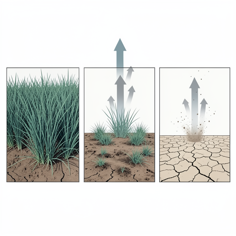
Vegetation Cover Threshold Concept
AI-generated conceptual illustration (Gobi Steppe rangeland soil and perennial grasses). It explains the idea and does not show study data.
View source evidence ↗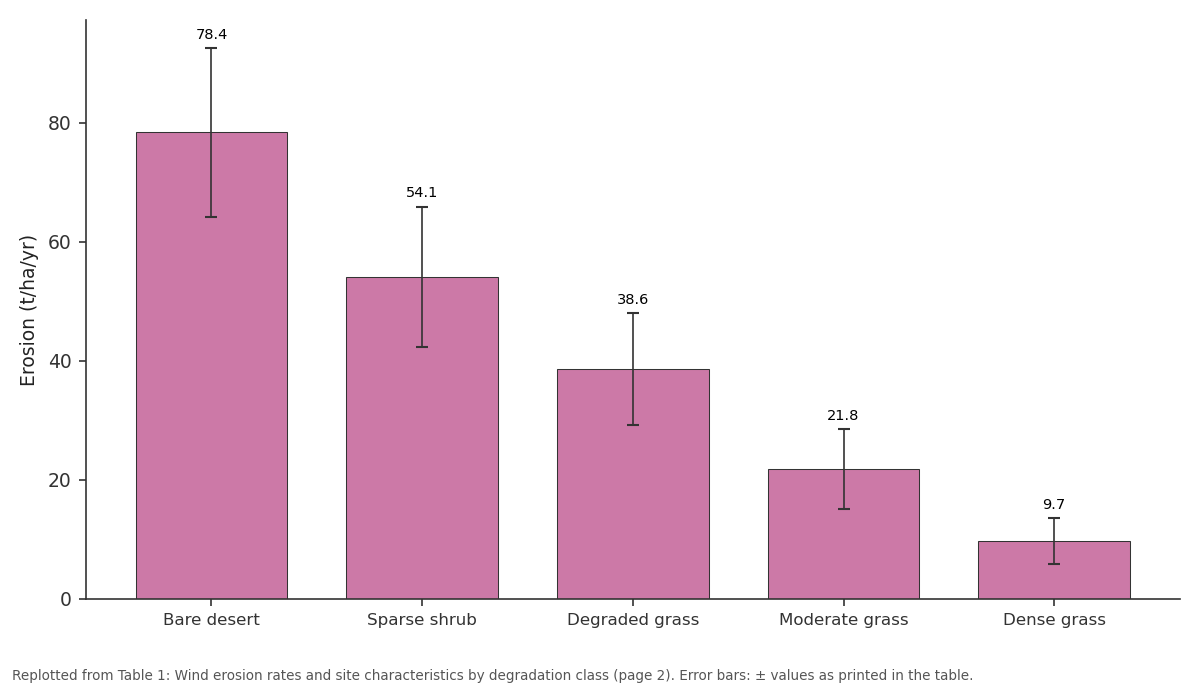
Erosion (t/ha/yr): Bare desert vs Sparse shrub vs Degraded grass vs Moderate grass vs Dense grass
Replotted from Table 1 (page 2) of the original paper. Every bar is the paper's own table value.
View source evidence ↗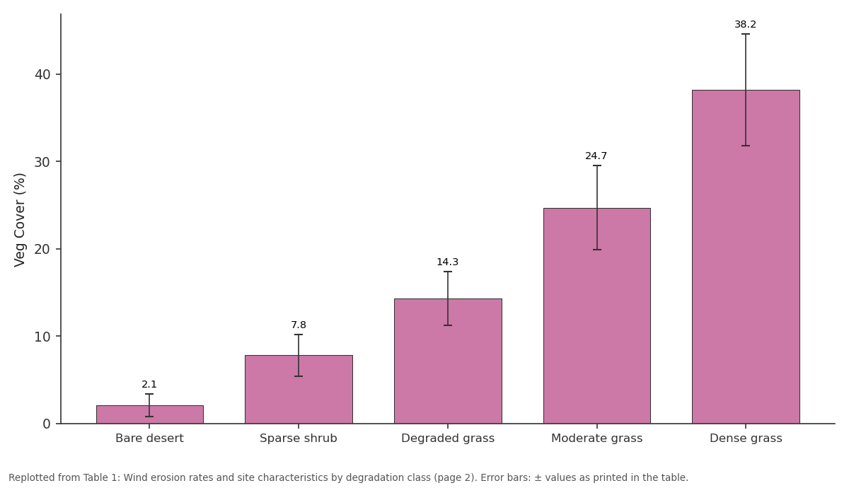
Veg Cover (%): Bare desert vs Sparse shrub vs Degraded grass vs Moderate grass vs Dense grass
Replotted from Table 1 (page 2) of the original paper. Every bar is the paper's own table value.
View source evidence ↗Figures & tables
From the original paper Table 1
 Table 2
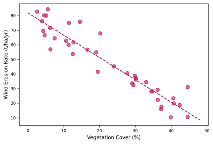 Figure 1
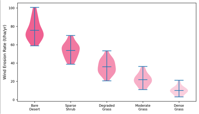 Figure 2
Introduction
Mongolia's rangelands support 70 million livestockmore than 20 times the human populationand that ratio has consequences for the land surface. Since the collapse of collective herding in 1990, animal numbers nearly tripled while rangeland management institutions weakened, leading to widespread overgrazing on the Gobi Steppe [1] . Stripped of its grass cover, the thin steppe soil becomes vulnerable to deflation by the strong westerly winds that sweep across central Asia for eight months of the year [2] . Wind erosion removes the finest, most fertile soil fraction firstsilt, clay, and organic matterleaving behind a coarsened, nutrient-poor surface that is increasingly difficult to revegetate [3] . The dust generated becomes a regional air quality issue: Mongolian dust storms contribute to the East Asian dust plume that reaches Korea, Japan, and even the western Pacific [4] . Despite the scale of the problem, field-based measurements of wind erosion rates across the Gobi Steppe remain scarce, with most estimates relying on modelling rather than direct observation [5] . This research addressed that gap by measuring erosion rates at 40 sites across five degradation classes and identifying the vegetation cover threshold that separates moderate from severe erosion [6] .
Study Area Description
The transect extends from 43°30′N to 46°00′N latitude and 100°00′E to 106°00′E longitude across the eastern Gobi Steppe of Dundgovi and Ömnögovi provinces. Elevation ranges from 1,100 to 1,600 m. The climate is continental semi-arid with mean annual temperature of 2.4°C, annual precipitation of 120-220 mm concentrated in June-August, and prevailing NW winds averaging 4.2-5.8 m/s. Soils are kastanozems and arenosols, with textures ranging from sandy loam to loamy sand [7] .
Materials and Methods
Materials and Methods
Materials
Field measurements were taken during two campaigns: October 2022 (post-grazing season) and April 2023 (pre-growing, peak wind season), coordinated from the Faculty of Geospatial Sciences, Bhopal, Madhya Pradesh, India. Forty sampling sites were stratified across five land degradation classes defined by MODIS NDVI: bare desert (<0.05), sparse shrub (0.05-0.10), degraded grassland (0.10-0.20), moderate grassland (0.20-0.30), and dense grassland (>0.30). At each site, a Big Spring Number Eight (BSNE) dust sampler array was installed at 15, 50, and 100 cm heights for 30-day deployment periods [8] .
Methods
Horizontal sediment flux at each height was computed from the collected mass divided by the sampler inlet area and deployment time. Total erosion rate was estimated by integrating the vertical flux profile using the exponential decay model of Shao and Raupach [9] . Vegetation cover was measured by line-point intercept along three 50 m transects per site. Dry aggregate stability was determined by the dry-sieving method (percentage of aggregates >0.84 mm). Wind data from the 12 nearest meteorological stations were used to calculate sand drift potential (DP) following the Fryberger and Dean [10] method. Correlations between erosion rate and predictor variables used Spearman rank correlation.
Climatic and Wind Regime Analysis
Sand drift potential ranged from 84 vector units (VU) at the eastern margin to 218 VU in the western Gobi, classifying the wind regime as intermediate to high energy. The resultant drift direction was consistently toward the ESE (mean 112°). The wind erosion season spans September-May, with peak activity in March-April when soil moisture is minimal and wind speeds peak.
Results
Results
Comprehensive Interpretation
The 15% vegetation cover threshold is consistent with theoretical predictions from the Raupach drag partition model, which predicts that surface shear stress on exposed soil drops below the threshold for grain entrainment when roughness elements (vegetation) cover approximately 14-18% of the surface [11] . Below this threshold, erosion accelerates non-linearly. This has practical significance: rangeland management policies that maintain cover above 15% would prevent the steepest erosion losses.
Discussion
The vegetation-erosion relationship documented here mirrors findings from the US Great Plains and the Sahel, where similar thresholds of 12-18% cover have been identified [3,12]. The Gobi context is distinctive in two ways: first, the wind regime is more energetic (DP up to 218 VU) than typical mid-latitude grasslands, and second, the growing season is extremely short (June-August), leaving soils exposed for nine months of the year. Aggregate stability emerges as the second most important predictor (r = -0.68). Soils with fewer coarse aggregates are more susceptible to abrasion and saltation bombardment, producing a positive feedback loop: erosion removes fine material, reducing aggregate stability, which in turn accelerates further erosion [13] .
Conclusion
Wind erosion rates in the Gobi Steppe range from 9.7 t/ha/yr on dense grassland to 78.4 t/ha/yr on bare desert. Vegetation cover is the strongest predictor (r = -0.86), with a threshold at approximately 15% below which erosion accelerates sharply. Over 41% of the surveyed transect falls in the highly susceptible category. Maintaining vegetation cover above 15% through grazing rotation, seasonal rest, and revegetation of bare patches is the most effective erosion control strategy for these rangelands.
Acknowledgement
Acknowledgements Funding SourcesSupported by research funds at the Faculty of Geospatial Sciences, Bhopal. Institutional SupportThe Department of Atmospheric Sciences provided wind data analysis resources. Contributions Not Qualifying for AuthorshipThe authors thank the Mongolian Institute of Meteorology for providing wind station records.
Figures and tables from the paper
| Class | n sites | Veg Cover (%) | Erosion (t/ha/yr) | Agg. Stab. (%) | Wind DP (VU) | Soil OC (%) |
|---|---|---|---|---|---|---|
| Bare desert | 8 | 2.1±1.3 | 78.4±14.2 | 22.3±6.1 | 194±32 | 0.18±0.06 |
| Sparse shrub | 8 | 7.8±2.4 | 54.1±11.8 | 31.7±7.4 | 172±28 | 0.31±0.09 |
| Degraded grass | 8 | 14.3±3.1 | 38.6±9.4 | 42.8±8.2 | 148±24 | 0.47±0.14 |
| Moderate grass | 8 | 24.7±4.8 | 21.8±6.7 | 56.4±9.8 | 131±21 | 0.68±0.18 |
| Dense grass | 8 | 38.2±6.4 | 9.7±3.8 | 68.1±10.3 | 118±19 | 0.92±0.22 |
Table text extracted from the original PDF; superscript letters are shown inline. The original table image is below.
View original table image
| Variable | Erosion Rate | Veg Cover | Agg. Stability | Wind DP |
|---|---|---|---|---|
| Erosion rate | 1.00 | –0.86** | –0.68** | 0.54** |
| Veg cover | –0.86** | 1.00 | 0.72** | –0.41** |
| Agg. stability | –0.68** | 0.72** | 1.00 | –0.28 |
| Wind DP | 0.54** | –0.41** | –0.28 | 1.00 |
Table text extracted from the original PDF; superscript letters are shown inline. The original table image is below.
View original table image
References
14 in the original paper- Fernandez-Gimenez ME. Sustaining the steppes: a geographical history of pastoral land use in Mongolia. Geographical Review. 1999;89(3):315-342.
- Natsagdorj L, Jugder D, Chung YS. Analysis of dust storms observed in Mongolia during 1937-1999. Atmospheric Environment. 2003;37(9):1401-1411.
- Leys JF, McTainsh GH. Soil loss and nutrient decline by wind erosion. Australian Journal of Soil Research. 1994;32(5):1053-1060.
- Sun J, Zhang M, Liu T. Spatial and temporal characteristics of dust storms in China and its surrounding regions. Atmospheric Environment. 2001;35(33):5659-5666.
- Shinoda M, Gillies JA, Mikami M. Temperate grasslands as a dust source. Anthropocene. 2011;3:1828.
- Lancaster N, Baas A. Influence of vegetation cover on sand transport by wind. Journal of Arid Environments. 1998;39(3):485-497.
- Batjargal Z. Desertification in Mongolia. RALA Report 200. Reykjavik: Agricultural Research Institute; 1997:107-113.
- Fryrear DW. A field dust sampler. Journal of Soil and Water Conservation. 1986;41(2):117-120.
- Shao Y, Raupach MR. Effect of saltation bombardment on the entrainment of dust. Journal of Geophysical Research. 1993;98(D7):12719-12726.
- Fryberger SG, Dean G. Dune forms and wind regime. USGS Professional Paper. 1979;1052:137-169.
- Raupach MR, Gillette DA, Leys JF. The effect of roughness elements on wind erosion threshold. Journal of Geophysical Research. 1993;98(D2):3023-3029.
- Wiggs GFS, Thomas DSG, Bullard JE. Dune mobility and vegetation cover in the southwest Kalahari. Earth Surface Processes and Landforms. 1995;20(6):515-529.
- Zobeck TM. Soil properties affecting wind erosion. Journal of Soil and Water Conservation. 1991;46(2):112-118.
- Middleton NJ, Thomas DSG. World Atlas of Desertification. 2nd ed. London: Arnold; 1997
Cited by 1
From OpenAlex, OpenCitations and reference lists read by Scinovex
- Interactive effects of grazing and climatic factors on grassland wind erosion: A global meta-analysis ↗
Bohan Zhang, yiqian shangguan, Z Y Li, Shijie Lv, Junran Li, Junran Li · SSRN Electronic Journal · 2026
❝ 0PDF