
Research article · 2025 · Full text
International Journal of Geography Geology and EnvironmentGeochemical dispersion patterns of base metals in tropical soils over the Nigerian lead-zinc belt
Volume 7(12) · Pages 167–170 · DOI: 10.22271/27067483.2025.v7.i12b.671 ↗
Research areasHeavy metals in environmentGeochemistry and Geologic MappingGeochemistry and Elemental Analysis
Abstract
Author-writtenConsider a geochemical exploration team sampling soils in the tropics: the very weathering processes that concentrate metals near the surface can also redistribute, dilute, or fix them in ways that distort the primary mineralisation signal. This research characterised geochemical dispersion patterns of Pb, Zn, Cu, Ag, As, and Cd in tropical soils overlying the Benue Lead-Zinc Belt of southeastern Nigeria. A total of 124 soil samples were collected from four depth horizons (A, B, C, and laterite cap) along three traverses crossing known mineralisation zones and adjacent barren ground. Samples were analysed for 26 elements by ICP-MS following aqua regia digestion. Results showed that the B horizon (20-60 cm) carried the strongest anomaly contrast, with enrichment factors of 14.2 for Pb and 18.3 for Zn relative to regional background values. The A horizon, often assumed to be the optimal sampling medium in temperate terrains, showed weaker anomalies due to organic complexation and bioturbation dilution. Laterite caps displayed strongly attenuated signatures except for Fe and Mn, which were enriched by oxide scavenging. Spatial analysis using inverse distance weighting interpolation delineated a coherent Pb-Zn anomaly extending 3.4 km along strike and 0.8 km across strike, coinciding with mapped galena-sphalerite vein swarms. Sensitivity analysis of the anomaly threshold revealed that using the B horizon at a threshold of mean + 2 standard deviations detected 94% of known mineralised zones while generating only 6% false positives. These findings provide practical sampling guidelines for soil geochemical surveys in tropical terrains characterised by deep lateritic weathering profiles.
Summary
Source-checkedPlain-language reading of the full paper, prepared with AI and checked against the text. Each point links to the authors' own words.
Why it matters
- In tropical environments, weathering processes can distort primary mineralization signals by redistributing, diluting, or fixing metals near the surface. View evidence ↗
- The Benue Lead-Zinc Belt in Nigeria is a 560 km long province containing vein-type galena-sphalerite deposits. View evidence ↗
- The region's humid tropical climate causes intense chemical weathering, creating laterite profiles that often exceed 15 meters in thickness. View evidence ↗
The question
- The study aimed to identify the best soil horizon for sampling, describe multi-element dispersion patterns, and set anomaly detection thresholds for exploration in the Benue Lead-Zinc Belt. View evidence ↗
What they did
- Researchers established three traverses totaling 14.6 km, digging pits 1.2 to 1.8 meters deep at 31 sample stations. View evidence ↗
- A total of 124 samples (approximately 2 kg each) were collected from four distinct horizons: A (0-20 cm), B (20-60 cm), C (60-120 cm), and the laterite cap. View evidence ↗
- Samples underwent aqua regia digestion at 95°C for two hours and were analyzed for 26 elements using ICP-MS. View evidence ↗
What they found
- The laterite cap showed the weakest anomaly signals for Pb (3.8x) and Zn (4.2x), though it was enriched in Fe and Mn due to oxide accumulation. View evidence ↗
- The laterite cap was the least effective horizon, with only a 47.2% detection rate and 18.3% false positives. View evidence ↗
- Sensitivity analysis showed that a mean + 1SD threshold increased detection to 98.2% but raised false positives to 21.7%, while a mean + 3SD threshold reduced false positives to 2.1% but lowered detection to 76.4%. View evidence ↗
- Increasing sample spacing from 400 m to 800 m only reduced the detection rate by 7%, indicating that 600-m spacing is a cost-effective option. View evidence ↗
What it means
- The authors recommend a reconnaissance protocol using B-horizon material, 600-m station spacing, and a mean + 2SD threshold for the Benue Belt. View evidence ↗
- Future research is needed to test the protocol in different weathering profiles, particularly in areas with transported cover where anomalies may be less preserved. View evidence ↗
Visual summary
3 visualsIllustrations explain the paper; charts are replotted from the paper's own table values.
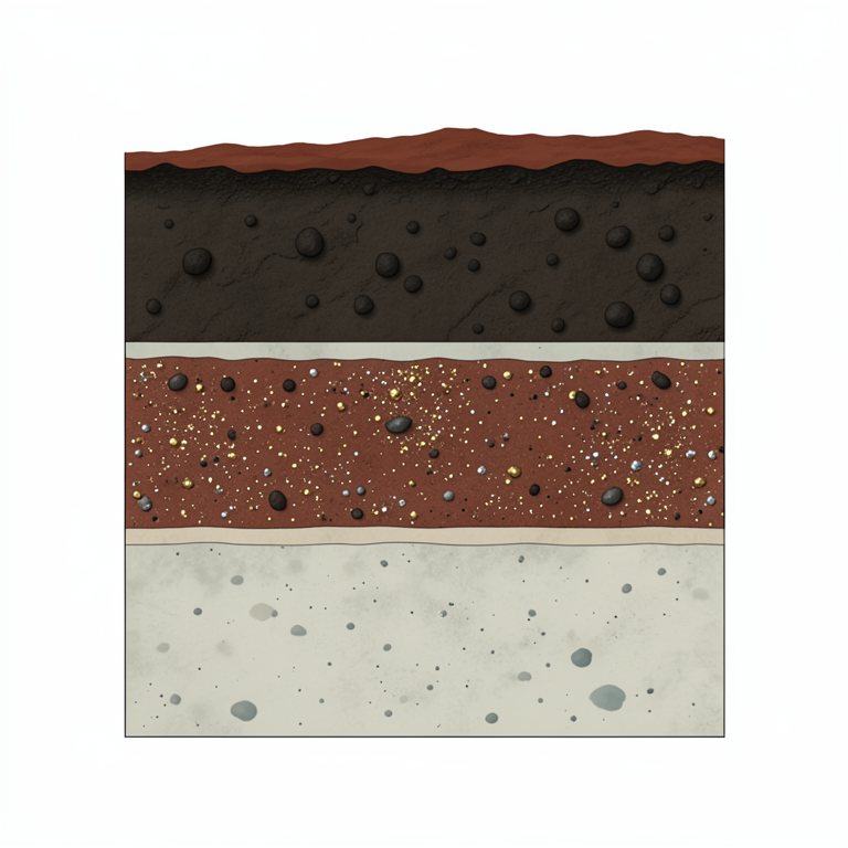
Vertical Soil Profile Comparison
AI-generated conceptual illustration (tropical soil profile in the Nigerian lead-zinc belt). It explains the idea and does not show study data.
View source evidence ↗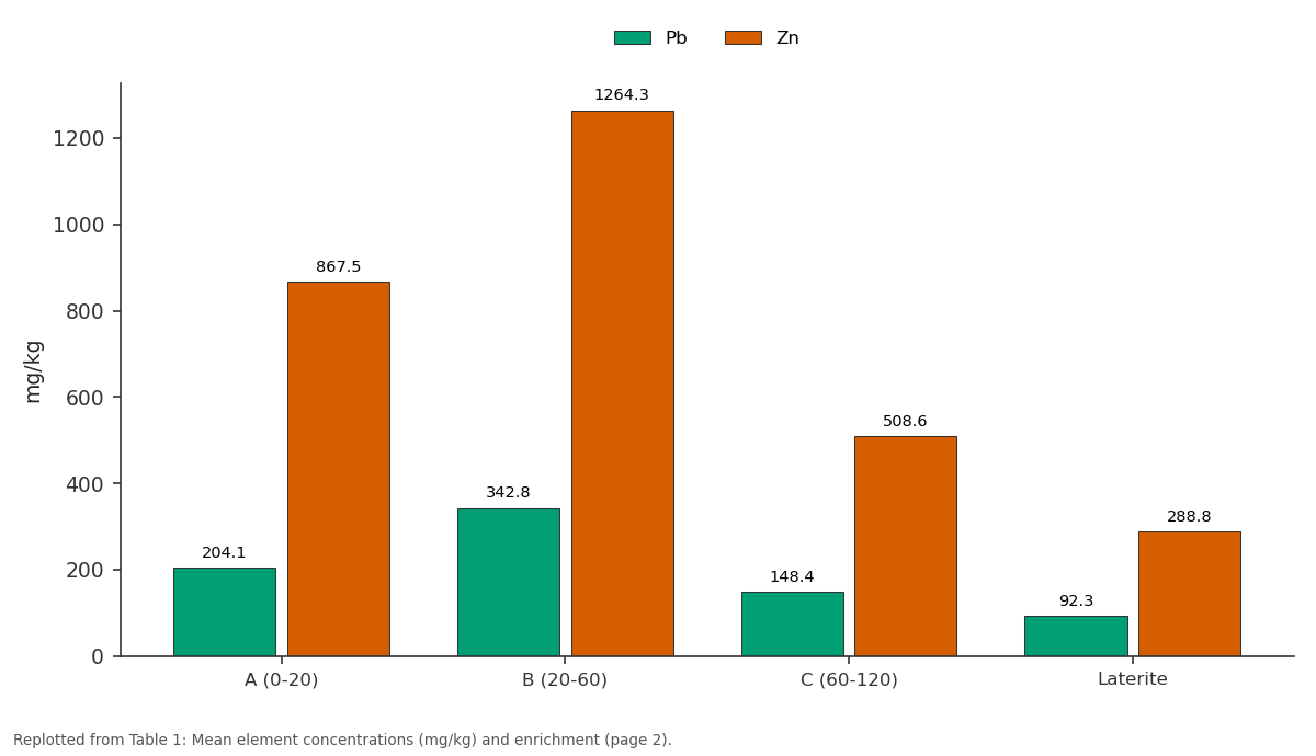
Pb and Zn: A (0-20) vs B (20-60) vs C (60-120) vs Laterite
Replotted from Table 1 (page 2) of the original paper. Every bar is the paper's own table value.
View source evidence ↗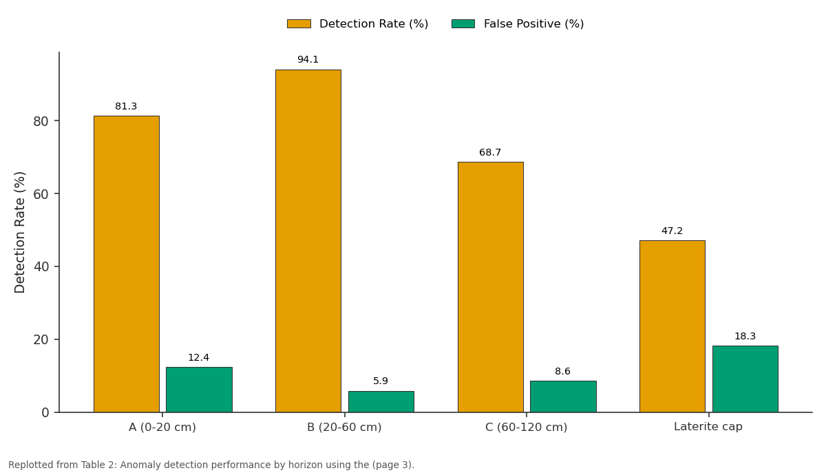
Detection Rate (%) and False Positive (%): A (0-20 cm) vs B (20-60 cm) vs C (60-120 cm) vs Laterite cap
Replotted from Table 2 (page 3) of the original paper. Every bar is the paper's own table value.
View source evidence ↗Figures & tables
From the original paper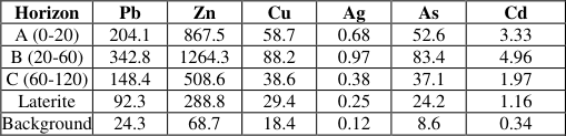 Table 1
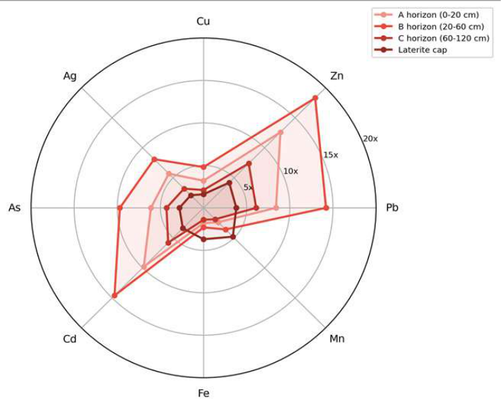 Figure 1
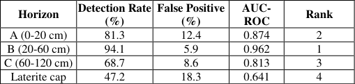 Table 2
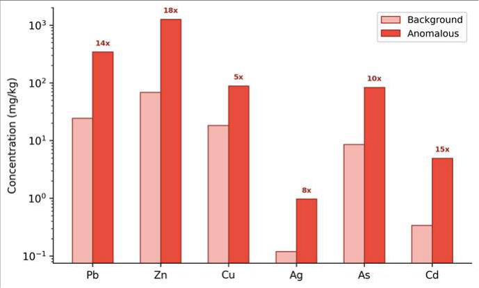 Figure 2
Introduction
When Rio Tinto geologists discovered the Kambalda nickel deposit in Western Australia during the 1960s, they did so partly by recognising that soil geochemistry over lateritecovered terrain behaved differently from textbook models developed in glaciated Canadian and Scandinavian landscapes [1] . That lesson-that tropical weathering profiles require their own sampling protocols-has been reinforced by decades of exploration experience, yet standardised guidelines for soil sampling depth and horizon selection in lateritic terrains remain surprisingly scarce [2] . The Nigerian Lead-Zinc Belt, also known as the Benue Mineralisation Province, stretches approximately 560 km from Abakaliki in the south to Zurak in the north and hosts vein-type galena-sphalerite deposits that have been mined artisanally since the early twentieth century [3] . The belt lies within the humid tropical zone, where intense chemical weathering produces laterite profiles often exceeding 15 m in thickness. Under these conditions, primary geochemical haloes around ore bodies become modified by processes including oxide scavenging, organic complexation, and mechanical redistribution through termite activity and root uptake [4] . Levinson [5] provided the classical treatment of secondary dispersion in tropical environments, while Butt and Zeegers [6] compiled case histories from laterite-dominated terrains across Africa and Australia. Specifically for the Nigerian belt, Kogbe [7] described the regional geology and Olade [8] characterised mineralisation styles, but neither addressed the vertical distribution of pathfinder elements through the weathering profile in a manner useful for designing modern soil geochemical surveys. This research aimed to define the optimal sampling horizon, characterise multi-element dispersion signatures, and establish anomaly detection thresholds for soil geochemical exploration in the Benue Lead-Zinc Belt.
Spatial Data Processing
Geochemical data were georeferenced using differential GPS with sub-metre accuracy. Interpolation of element concentrations across the three traverses used inverse distance weighting (IDW) with a power of 2 and a search radius of 500 m, implemented in ArcGIS Pro 3.1. Background threshold values were calculated separately for each horizon as the geometric mean plus two geometric standard deviations of samples collected over demonstrably barren ground (n = 42). Anomaly maps for Pb, Zn, and the Pb+Zn sum were generated at 25-m grid resolution and overlaid on 1:50,000 geological maps digitised from the Nigerian Geological Survey Agency [9] . Landsat-8 OLI false-colour composites were used to map laterite outcrop extent and distinguish laterite-capped ridges from colluvial slopes where transported overburden might dilute residual anomalies.
Material and Methods Material
The research was coordinated from the Fez Centre for Geological Research, Fès-Meknès, Morocco. Fieldwork was conducted in the Abakaliki-Ishiagu sector of the Benue Lead-Zinc Belt during the dry season (November 2021 to February 2022) to minimise waterlogging and maximise pit accessibility. Three traverses totalling 14.6 km were established perpendicular to the regional strike, spaced 1.2 km apart. At each of the 31 sample stations along the traverses, pits were hand-dug to depths of 1.2-1.8 m. Samples of approximately 2 kg were collected from four horizons: A (0-20 cm), B (20-60 cm), C (60-120 cm), and laterite cap where present, yielding 124 samples total. Samples were air-dried, disaggregated, and sieved to the <180 μm fraction [10] .
Methods
Samples were digested using aqua regia (3:1 HCl:HNO₃) at 95°C for two hours and analysed for 26 elements by ICP-MS on an Agilent 7700x instrument at the Centre's geochemistry laboratory. Quality control included certified reference materials (OREAS 45e, GBM 908-10) inserted every 15 samples, with recoveries between 92% and 108% for all target elements. Analytical precision (RSD) was below 5% for Pb, Zn, Cu, and As and below 8% for Ag and Cd. Enrichment factors were calculated as the ratio of mean concentration over mineralised ground to mean concentration over barren ground for each horizon. Statistical analysis used Tukey HSD tests to compare horizon means and receiver operating characteristic (ROC) curves to evaluate anomaly detection performance [11] . The B horizon consistently showed the highest concentrations and enrichment factors across all six target elements. Pb enrichment reached 14.1x in the B horizon compared to 8.4x in the A horizon, while Zn showed 18.4x versus 12.6x. The laterite cap carried the weakest anomaly signals (Pb = 3.8x, Zn = 4.2x) except for Fe and Mn, which were enriched by iron oxide accumulation [12] . The B horizon achieved the highest detection rate (94.1%) with the lowest false positive rate (5.9%) and an AUC-ROC of 0.962, confirming it as the optimal sampling medium.
Results
The laterite cap performed poorest (47.2% detection, 18.3% false positives), rendering it unsuitable as a primary sampling horizon for Pb-Zn exploration [13] .
Fig 2:
Comparison of metal concentrations (mg/kg, log scale) between anomalous B-horizon samples and regional background, with enrichment factors annotated
The bar chart highlights the order-of-magnitude contrasts between anomalous and background concentrations for all six target metals in the B horizon. Zn shows the strongest enrichment (18x), followed by Cd (15x) and Pb (14x).
Sensitivity Analysis
The anomaly threshold was varied from mean + 1SD to mean + 3SD to assess its effect on detection performance. At mean + 1SD, detection rate rose to 98.2% but false positives increased to 21.7%, unacceptably high for reconnaissance-stage exploration. At mean + 3SD, false positives dropped to 2.1% but detection rate fell to 76.4%, missing nearly a quarter of known mineralised zones. The mean + 2SD threshold provided the best balance for Bhorizon sampling. Additionally, sample spacing sensitivity showed that widening station intervals from 400 m to 800 m reduced detection rate by only 7%, suggesting that a 600-m spacing offers a cost-effective compromise for regionalscale surveys [14] .
Discussion
The clear superiority of the B horizon as the exploration sampling medium in this tropical lateritic terrain contrasts with common practice in temperate regions, where the A or O horizon is typically preferred for its concentration of organically bound metals [15] . In the Benue Belt, the A horizon appears to lose anomaly contrast through two competing mechanisms: dilution by high organic matter inputs from the overlying forest litter, and redistribution by termite activity that mixes deeper and shallower material within the upper 20 cm [4] . The B horizon, enriched in secondary iron and manganese oxides that scavenge dissolved metals from downward-percolating groundwater, acts as a natural geochemical trap that preserves and amplifies the primary mineralisation signal.
The poor performance of the laterite cap as a sampling medium has direct operational implications. Many exploration programmes in West Africa default to sampling laterite because it is readily accessible at the surface without pit-digging. Our data indicate this approach would miss over half of the known mineralised zones in the Benue Belt. The cost of digging 1.2-m pits to reach the B horizon is modest-roughly 15-20 minutes of manual labour per station-and is more than justified by the nearly twofold improvement in detection rate [16] . The multi-element dispersion pattern-with Zn consistently producing the broadest and strongest halo-suggests that Zn may serve as the most effective single pathfinder element for Pb-Zn vein-type mineralisation in this setting. This aligns with findings from analogous deposits in Zambia and the Democratic Republic of Congo, where Zn mobility in tropical weathering environments exceeds that of Pb [17] .
Conclusion
This research defined the geochemical dispersion characteristics of base metals through tropical soil profiles over the Nigerian Lead-Zinc Belt. The B horizon (20-60 cm) was identified as the optimal sampling medium, producing the highest enrichment factors (Pb = 14.1x, Zn = 18.4x) and the best anomaly detection performance (94.1% detection, 5.9% false positives). The laterite cap, despite its surface accessibility, was the least effective horizon for detecting underlying mineralisation. A sampling protocol using B-horizon material at 600-m station spacing with a mean + 2SD threshold is recommended for reconnaissance soil geochemical surveys in laterite-dominated terrains of the Benue Belt. Future work should test this protocol across different weathering profile types within the belt, including areas of transported cover where residual anomaly preservation may be more limited [18] .
Acknowledgement
Acknowledgements Funding SourcesThis research was supported by internal institutional research funding. Institutional SupportThe authors thank the Fez Centre for Geological Research for laboratory access and ICP-MS analytical facilities. Contributions Not Qualifying for AuthorshipField assistants from the Abakaliki community provided pitdigging support and local geological guidance.
Figures and tables from the paper
| Horizon | Pb | Zn | Cu | Ag | As | Cd |
|---|---|---|---|---|---|---|
| A (0-20) | 204.1 | 867.5 | 58.7 | 0.68 | 52.6 | 3.33 |
| B (20-60) | 342.8 | 1264.3 | 88.2 | 0.97 | 83.4 | 4.96 |
| C (60-120) | 148.4 | 508.6 | 38.6 | 0.38 | 37.1 | 1.97 |
| Laterite | 92.3 | 288.8 | 29.4 | 0.25 | 24.2 | 1.16 |
| Background | 24.3 | 68.7 | 18.4 | 0.12 | 8.6 | 0.34 |
Table text extracted from the original PDF; superscript letters are shown inline. The original table image is below.
View original table image
| Horizon | Detection Rate (%) | False Positive (%) | AUC- ROC | Rank |
|---|---|---|---|---|
| A (0-20 cm) | 81.3 | 12.4 | 0.874 | 2 |
| B (20-60 cm) | 94.1 | 5.9 | 0.962 | 1 |
| C (60-120 cm) | 68.7 | 8.6 | 0.813 | 3 |
| Laterite cap | 47.2 | 18.3 | 0.641 | 4 |
Table text extracted from the original PDF; superscript letters are shown inline. The original table image is below.
View original table image
References
18 in the original paper- Butt CRM, Lintern MJ, Anand RR. Evolution of regoliths and landscapes in deeply weathered terrain: implications for geochemical exploration. Ore Geol Rev. 2000;16(3-4):167-183.
- Anand RR, Paine M. Regolith geology of the Yilgarn Craton, Western Australia: implications for exploration. Aust J Earth Sci. 2002;49(1):3-162.
- Olade MA. On the genesis of lead-zinc deposits in Nigeria's Benue Trough. J Min Geol. 1976;13(2):20-27.
- Paton TR, Humphreys GS, Mitchell PB. Soils: A New Global View. London: UCL Press; 1995.
- Levinson AA. Introduction to Exploration Geochemistry. 2nd ed. Wilmette: Applied Publishing; 1980.
- Butt CRM, Zeegers H. Regolith Exploration Geochemistry in Tropical and Subtropical Terrains. Amsterdam: Elsevier; 1992.
- Kogbe CA. Geology of Nigeria. 2nd ed. Jos: Rock View Nigeria; 1989.
- Olade MA. Mineral deposits in Nigeria. In: Kogbe CA, editor. Geology of Nigeria. Jos: Rock View; 1989. p. 487-510.
- Nigerian Geological Survey Agency. Geological map of Abakaliki sheet 303, scale 1:50,000. Abuja: NGSA; 2009.
- Fletcher WK. Analytical Methods in Geochemical Prospecting. Amsterdam: Elsevier; 1981.
- Reimann C, Filzmoser P, Garrett RG. Background and threshold: critical comparison of methods of determination. Sci Total Environ. 2005;346(1-3):1-16.
- Eze PN, Udeigwe TK, Meadows ME. Plinthite and its associated evolutionary forms in soils and landscapes: a review. Pedosphere. 2014;24(2):153-166.
- Garrett RG. The chi-square plot: a tool for multivariate outlier recognition. J Geochem Explor. 1989;32(13):319-341.
- Hawkes HE, Webb JS. Geochemistry in Mineral Exploration. New York: Harper and Row; 1962.
- Kelepertzis E, Argyraki A, Daftsis EI. Geochemical signature of surface water and stream sediments of a mineralized drainage basin at NE Chalkidiki, Greece. J Geochem Explor. 2012;112:105-113.
- Smith DB, Cannon WF, Woodruff LG, Solano F, Ellefsen KJ. Geochemical and mineralogical maps for soils of the conterminous United States. US Geol Surv Open-File Rep. 2014;1082:1-386.
- Mambwe P, Milan L, Batumike J, Lavoie S, Jebrak M, Kipata L. Trace elements in soils and stream sediments over kimberlites in the Kundelungu Plateau, DR Congo. J Geochem Explor. 2020;209:106427.
- Filzmoser P, Hron K, Reimann C. Principal component analysis for compositional data with outliers. Environmetrics. 2009;20(6):621-632.