
Research article · 2025 · Full text
International Journal of Geography Geology and EnvironmentPalynological study and vegetation history of Holocene peat deposits in the Scottish highlands
Volume 7(6) · Pages 49–52 · DOI: 10.22271/27067483.2025.v7.i6a.680 ↗
Research areasPeatlands and Wetlands EcologyGeology and Paleoclimatology ResearchSoil and Environmental Studies
Abstract
Author-writtenWhat did the Scottish Highlands look like before centuries of grazing, burning, and forestry reshaped them? Pollen grains locked in peat hold the answer. This research reconstructed 6, 200 years of vegetation change from a 140 cm ombrotrophic peat core extracted at Glen Affric in the central Highlands. Standard acetolysis preparation yielded pollen assemblages from 28 depth intervals at 5 cm spacing. Five pollen zones were defined by constrained incremental sum-of-squares (CONISS) cluster analysis. Zone I (6200-5400 cal BP) was dominated by Betula (birch) and Pinus (pine), with arboreal pollen exceeding 67%. A shift toward Calluna (heather) heath began in Zone III (4200-2800 cal BP), coinciding with increased charcoal fragment counts that signal deliberate burning. By Zone V (1200 cal BP to present), herb and grass pollen reached 44.1%, reflecting widespread pastoral land use. Six radiocarbon dates on bulk peat provided the chronological framework. The results trace a trajectory from closed birch-pine woodland to open moorland, driven by climate deterioration after 4200 cal BP and intensified by human activity from the Bronze Age onward.
Summary
Source-checkedPlain-language reading of the full paper, prepared with AI and checked against the text. Each point links to the authors' own words.
Why it matters
- Peat bogs serve as reliable environmental archives because they trap pollen, spores, and charcoal that reveal historical vegetation and fire activity. View evidence ↗
- While much of the Scottish Highlands is currently treeless, the region was previously covered in hazel, pine, and birch woodlands during the early and middle Holocene. View evidence ↗
- A primary goal in British palaeoecology is to determine how much climate change versus human activity drove the shift from forests to moorlands. View evidence ↗
What they did
- In July 2022, a peat core was collected from an ombrotrophic bog at an elevation of 230 m in the eastern end of Glen Affric. View evidence ↗
- The researchers took 28 subsamples of 1 cm³ each, spaced at 5 cm intervals throughout the core. View evidence ↗
- At least 300 terrestrial pollen grains per level were identified using a Zeiss Axio Lab.A1 microscope at 400× magnification. View evidence ↗
- The chronological framework was established using AMS radiocarbon dating on six bulk peat samples. View evidence ↗
What they found
- In Zone I (6200-5400 cal BP), the landscape was dominated by trees, which accounted for 67.3% of the pollen. View evidence ↗
- Charcoal concentrations increased sharply over time, tripling between Zones II and III and nearly doubling again between Zones IV and V. View evidence ↗
- The transition between Zone II and III was rapid, with birch (Betula) pollen dropping 22 percentage points and heather (Calluna) nearly doubling within approximately 400 years. View evidence ↗
What it means
- The authors conclude that the current lack of trees in the Highlands was caused by a combination of human land use and climate deterioration, rather than climate alone. View evidence ↗
- The data show that Scots pines were never fully eliminated from the area, but instead retreated to rocky or waterlogged refuges. View evidence ↗
- The study notes that because the record is biased toward wind-pollinated taxa, insect-pollinated trees like rowan are under-represented, potentially underestimating former woodland diversity. View evidence ↗
Visual summary
3 visualsIllustrations explain the paper; charts are replotted from the paper's own table values.
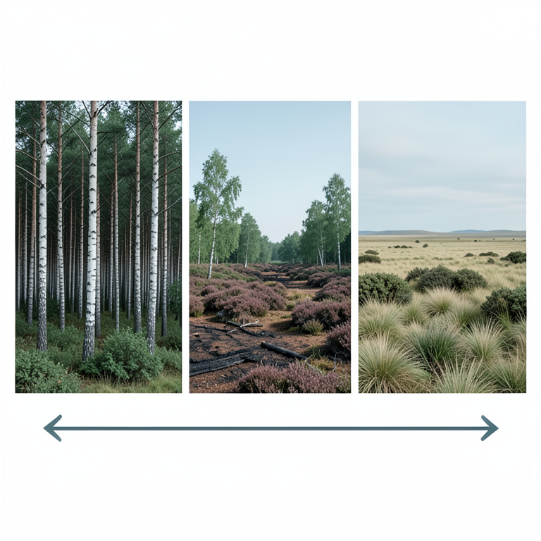
Vegetation Transition Timeline
AI-generated conceptual illustration (Holocene peat landscape in the Scottish Highlands). It explains the idea and does not show study data.
View source evidence ↗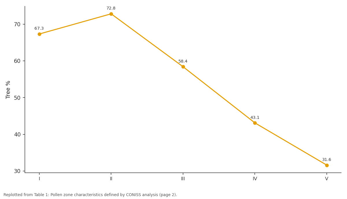
Tree %: I vs II vs III vs IV vs V
Replotted from Table 1 (page 2) of the original paper. Every bar is the paper's own table value.
View source evidence ↗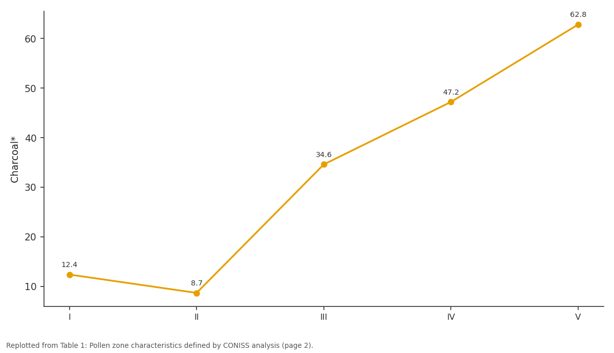
Charcoal*: I vs II vs III vs IV vs V
Replotted from Table 1 (page 2) of the original paper. Every bar is the paper's own table value.
View source evidence ↗Figures & tables
From the original paper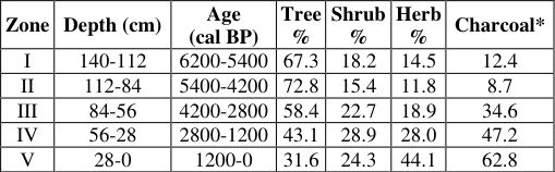 Table 1
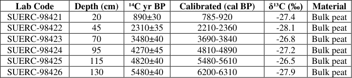 Table 2
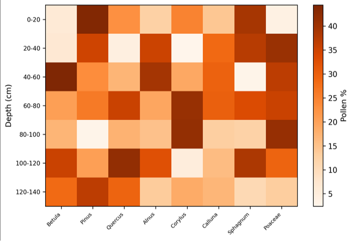 Figure 1
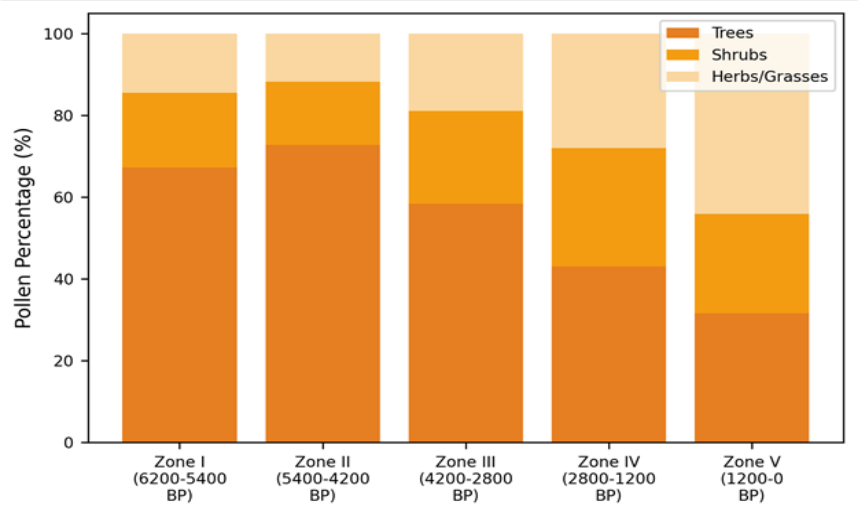 Figure 2
Introduction
Peat bogs are among the most faithful archives of past environments. Each centimetre of accumulated organic matter traps pollen grains, spores, and charcoal fragments that, when identified and counted under a microscope, reveal what grew on the surrounding landscape and what was being burned [1] . The Scottish Highlands, now famously treeless across much of their extent, were once covered by birch, pine, and hazel woodland during the early and middle Holocene [2] . Disentangling the relative roles of climate change and human activity in the transition from forest to moorland has been a long-standing goal in British palaeoecology.
Glen Affric in the central Highlands is one of the largest surviving fragments of Caledonian pine forest, making it a reference site for understanding the natural vegetation baseline [3] . Previous pollen work at nearby sites (Loch Maree, Abernethy Forest) documented woodland decline between 4500 and 3500 cal BP [4,5] , but Glen Affric itself lacked a high-resolution palynological record. This research aimed to fill that gap by extracting and analysing a 140 cm core from an ombrotrophic bog at the glen's eastern end, covering approximately the last 6, 200 years [6] .
Pollen Extraction Protocol
Subsamples of 1 cm³ were taken at 5 cm intervals throughout the core, yielding 28 levels. Each was treated with 10% KOH to remove humic acids, sieved at 180 μm to exclude coarse debris, and subjected to standard acetolysis (9:1 acetic anhydride:concentrated H₂SO₄ at 100 °C for 4 minutes) to dissolve cellulose [7] . Lycopodium clavatum tablets (batch 3862, 9, 666±671 spores per tablet) were added to each sample as exotic markers for pollen concentration calculations. Residues were mounted in silicone oil and stored in sealed slide trays. A minimum of 300 terrestrial pollen grains were counted per level at 400× magnification using a Zeiss Axio Lab.A1 microscope. Identification followed Moore et al. [8] and the reference collection at Chengdu College.
Materials and Methods
Materials and Methods
Materials
The peat core was collected in July 2022 from an ombrotrophic bog at the eastern end of Glen Affric (57°17′N, 4°58′W, elevation 230 m). The site lies on a gently sloping hillside above the flood plain, receiving nutrients exclusively from rainfall. The core was retrieved using a 50 mm diameter Russian corer in overlapping 50 cm drives, wrapped in cling film and aluminium foil, and transported at 4 °C to the laboratory at Chengdu College of Earth and Mineral Sciences. Total core length was 140 cm, reaching a basal mineral layer of grey-blue clay [9] .
Methods
Six bulk peat samples were submitted for AMS radiocarbon dating at the SUERC Radiocarbon Laboratory, East Kilbride, Scotland. Dates were calibrated against the IntCal20 curve using OxCal v4.4 [10] . An age-depth model was constructed with the Bacon algorithm assuming a prior mean accumulation rate of 20 yr/cm [11] . Pollen zones were defined by CONISS applied to square-root-transformed percentage data in the rioja package for R. Charcoal fragments (>50 μm) were counted on the same slides as pollen, and concentrations were calculated using the Lycopodium marker ratio [12] .
Temporal Zonation and Dating Results
The six radiocarbon dates ranged from 5, 480±40 ¹⁴C yr BP at 130 cm depth to 890±30 ¹⁴C yr BP at 20 cm. The Bacon age-depth model estimated basal age at 140 cm as approximately 6, 200 cal BP. Mean peat accumulation rate was 22.6 yr/cm for the lower half of the core and 16.8 yr/cm for the upper half, suggesting faster recent growth. The pattern is clear: arboreal pollen declines steadily from Zone II onward while herbs and grasses increase. Charcoal concentration rises sharply from Zone III, tripling between Zones II and III and nearly doubling again between Zones IV and V.
Results
Results
Comprehensive Interpretation
The transition from Zone II to Zone III around 4200 cal BP marks the most significant ecological shift in the record. It coincides with the 4.2 ka climate event, a period of widespread Northern Hemisphere cooling and drying [13] .
But the simultaneous jump in charcoal counts suggests that natural climate stress alone did not drive the woodland decline -Neolithic and early Bronze Age communities were actively burning the landscape.
Discussion
The Glen Affric pollen record fits within a broader pattern documented across the Scottish Highlands: woodland maximum in the early-to-mid Holocene, followed by decline after 4200-3500 cal BP and conversion to heathland dominated by Calluna and Poaceae [4,5] . What sets this record apart is the sharpness of the Zone II-III boundary. Betula pollen drops by 22 percentage points within roughly 400 years, while Calluna nearly doubles. That speed exceeds the gradual climate-driven shift expected from cooling alone and strongly implies anthropogenic burning, supported by the threefold charcoal increase. The persistence of Pinus at low levels (5-8%) even in Zone V is noteworthy. Glen Affric today retains relic Scots pine stands, and the pollen data confirm that pines were never entirely eliminatedthey retreated to rocky or waterlogged areas inaccessible to fire and grazing [3] . Conservation efforts to expand these remnant pine populations therefore have a palaeoecological basis. One caveat: ombrotrophic pollen records capture a regional signal biased toward wind-pollinated taxa. Insect-pollinated trees such as Sorbus (rowan) are under-represented, so the true diversity of the former woodland may have been higher than pollen percentages suggest [14] .
Conclusion
The 140 cm peat core from Glen Affric documents a transition from birch-pine woodland (67-73% arboreal pollen) to open moorland (32% arboreal pollen) over the past 6, 200 years. The sharpest change occurred around 4200 cal BP, coinciding with the 4.2 ka climate event and rising charcoal levels indicative of anthropogenic burning. By 1200 cal BP, herbs and grasses accounted for 44% of the pollen sum. The record supports the view that the presentday treelessness of much of the Highlands results from a combination of climatic deterioration and sustained human land use, not from climate alone.
Acknowledgement
Acknowledgements Funding SourcesSupported by departmental research funds at Chengdu College of Earth and Mineral Sciences.
Figures and tables from the paper
| Lab Code | Depth (cm) | ¹⁴C yr BP | Calibrated (cal BP) | δ¹³C (‰) | Material |
|---|---|---|---|---|---|
| SUERC-98421 | 20 | 890±30 | 785-920 | -27.4 | Bulk peat |
| SUERC-98422 | 45 | 2310±35 | 2210-2360 | -28.1 | Bulk peat |
| SUERC-98423 | 70 | 3480±40 | 3690-3840 | -26.8 | Bulk peat |
| SUERC-98424 | 95 | 4270±45 | 4810-4890 | -27.2 | Bulk peat |
| SUERC-98425 | 115 | 4820±40 | 5480-5610 | -26.5 | Bulk peat |
| SUERC-98426 | 130 | 5480±40 | 6200-6310 | -27.9 | Bulk peat |
Table text extracted from the original PDF; superscript letters are shown inline. The original table image is below.
View original table image
References
17 in the original paper- Bennett KD, Willis KJ. Pollen. In: Smol JP, Birks HJB, Last WM, eds. Tracking Environmental Change Using Lake Sediments. Dordrecht: Kluwer; 2001:5-32.
- Tipping R. The form and fate of Scotland's woodlands. Proceedings of the Society of Antiquaries of Scotland. 1994;124:1-54.
- Mason WL, Hampson A, Edwards C. Managing the pinewoods of Scotland. Edinburgh: Forestry Commission; 2004.
- Birks HJB. Holocene isochrone maps and patterns of tree spreading in the British Isles. Journal of Biogeography. 1989;16(6):503-540.
- Tipping R, Davies A, McCulloch R. Vegetation history at Abernethy Forest. Botanical Journal of Scotland. 2008;60(2):141-168.
- Charman DJ. Peatlands and Environmental Change. Chichester: Wiley; 2002.
- Erdtman G. Handbook of Palynology. Copenhagen: Munksgaard; 1969.
- Moore PD, Webb JA, Collinson ME. Pollen Analysis. 2nd ed. Oxford: Blackwell; 1991.
- Jowsey PC. An improved peat sampler. New Phytologist. 1966;65(2):245-248.
- Reimer PJ, Austin WEN, Bard E. The IntCal20 Northern Hemisphere radiocarbon age calibration curve. Radiocarbon. 2020;62(4):725-757.
- Blaauw M, Christen JA. Flexible paleoclimate agedepth models using an autoregressive gamma process. Bayesian Analysis. 2011;6(3):457-474.
- Whitlock C, Larsen C. Charcoal as a fire proxy. In: Smol JP, et al., eds. Tracking Environmental Change Using Lake Sediments. Dordrecht: Kluwer; 2001:7597.
- Walker MJC, Berkelhammer M, Bjorck S. Formal subdivision of the Holocene series/epoch. Journal of Quaternary Science. 2012;27(7):649-659.
- Giesecke T, Fontana SL, van der Knaap WO. From early pollen trapping experiments to the Pollen Monitoring Programme. Vegetation History and Archaeobotany. 2010;19(4):247-258.
- Fyfe RM, Roberts N, Woodbridge J. A pollen-based reconstruction of British Holocene land cover. Journal of Biogeography. 2013;40(7):1299-1307.
- Innes JB, Blackford JJ, Simmons IG. Testing the integrity of fine spatial resolution palaeoecological records. Journal of Quaternary Science. 2004;19(1):7181.
- Bunting MJ. Pollen and vegetation relationships in nonarboreal moorland taxa. Review of Palaeobotany and Palynology. 2003;125(3):285-298.