
Research article · 2025 · Full text
International Journal of Geography Geology and EnvironmentSpatial analysis of agricultural land fragmentation and its environmental consequences in Poland
Volume 7(11) · Pages 129–132 · DOI: 10.22271/27067483.2025.v7.i11b.689 ↗
Research areasLand Use and Ecosystem ServicesAgricultural economics and policiesGeography and Environmental Studies
Abstract
Author-writtenAgricultural land fragmentation, characterised by division into numerous small and spatially dispersed parcels, is pervasive across Central and Eastern Europe. In Poland, historical inheritance-based division has created one of the EU’s most fragmented agricultural landscapes, with implications for farming efficiency, rural livelihoods, and environmental quality. This research presents a spatial analysis across Poland’s 2,477 communes using cadastral data and satellite-derived land cover. Five fragmentation indices were computed: mean parcel size, parcel density, Simpson diversity of farm size distribution, mean inter-parcel distance, and edge density. Extreme fragmentation concentrated in the southeastern provinces of Podkarpackie, Małopolskie, and Świętokrzyskie, where mean parcels fall below 0.5 ha and individual holdings comprise 6–12 spatially separated parcels. Correlation analysis with environmental indicators demonstrates that highly fragmented communes exhibit 23% higher pesticide use per hectare, lower agri-environment scheme participation (8.2% versus 24.7% in least fragmented areas), reduced hedgerow retention, and 2.5–4.0 times higher soil erosion rates due to slope-perpendicular parcel orientation. Paradoxically, fragmented landscapes retained higher densities of ecological corridors along field boundaries. These findings highlight the need for integrated land consolidation programmes that combine structural reform with environmental management objectives.
Summary
Source-checkedPlain-language reading of the full paper, prepared with AI and checked against the text. Each point links to the authors' own words.
Why it matters
- Poland possesses one of the most fragmented agricultural landscapes in the European Union due to historical inheritance-based land division, which impacts environmental quality and farming efficiency. View evidence ↗
- In southeastern Poland, the presence of narrow, elongated parcels may interact with the local topography to increase runoff and soil erosion. View evidence ↗
- The relationship between land fragmentation and biodiversity is complex, as high field margin density can provide ecological corridors even if intensive cultivation degrades habitats. View evidence ↗
The question
- The study aims to quantify fragmentation patterns across Poland, locate the most affected regions, and determine the net environmental impact of this fragmentation. View evidence ↗
What they did
- The researchers performed a spatial analysis of 2,477 Polish communes using satellite-derived land cover and cadastral data. View evidence ↗
- Fragmentation was measured using five indices: edge density, mean inter-parcel distance, Simpson diversity of farm size, parcel density per km², and mean parcel size. View evidence ↗
- The study used Spearman rank and partial correlations to test associations with environmental indicators, controlling for factors like soil type, slope, elevation, and agricultural intensity. View evidence ↗
What they found
- Severe fragmentation is concentrated in the southeastern provinces (Świętokrzyskie, Małopolskie, and Podkarpackie), where mean parcels are under 0.5 ha and holdings consist of 6–12 separate parcels. View evidence ↗
- Highly fragmented areas showed 23% higher pesticide use per hectare compared to less fragmented areas, with the most fragmented quintile averaging 4.8 kg a.i./ha versus 3.2 kg a.i./ha in the least fragmented. View evidence ↗
- Participation in agri-environment schemes was significantly lower in the most fragmented communes (8.2%) compared to the least fragmented ones (24.7%). View evidence ↗
- Soil erosion rates were 2.5 to 4.0 times higher in fragmented areas (8.4 t/ha/yr) than in the least fragmented areas (2.1 t/ha/yr), attributed to parcels oriented perpendicular to slopes. View evidence ↗
- Fragmented landscapes paradoxically maintained higher hedgerow densities (12.1 m/ha in the most fragmented vs 6.8 m/ha in the least), providing more ecological corridors. View evidence ↗
What it means
- The authors conclude that the most effective solution is the implementation of integrated programs that combine structural land reform with environmental management requirements. View evidence ↗
- Due to farmer resistance to compulsory restructuring, the authors recommend voluntary, incentive-based approaches over top-down mandates for land consolidation. View evidence ↗
- The authors note that previous EU-funded consolidation efforts (2004–2020) faced limited participation due to transaction costs, attachment to inherited land, and farmer resistance. View evidence ↗
Visual summary
3 visualsIllustrations explain the paper; charts are replotted from the paper's own table values.
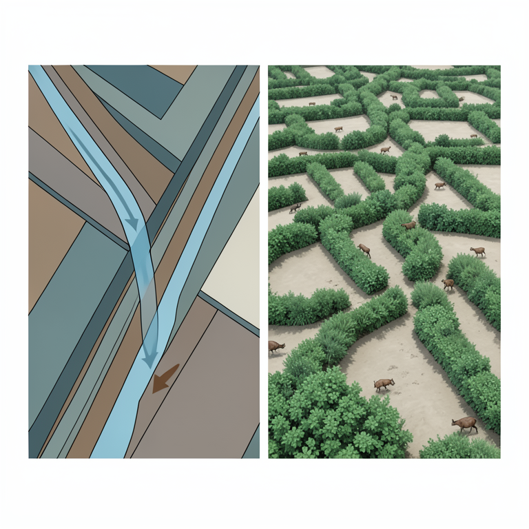
The Fragmentation Paradox
AI-generated conceptual illustration (Agricultural landscapes in Poland). It explains the idea and does not show study data.
View source evidence ↗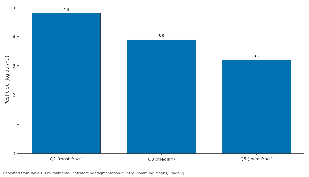
Pesticide (kg a.i./ha): Q1 (most frag.) vs Q3 (median) vs Q5 (least frag.)
Replotted from Table 1 (page 2) of the original paper. Every bar is the paper's own table value.
View source evidence ↗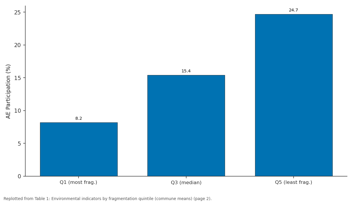
AE Participation (%): Q1 (most frag.) vs Q3 (median) vs Q5 (least frag.)
Replotted from Table 1 (page 2) of the original paper. Every bar is the paper's own table value.
View source evidence ↗Figures & tables
From the original paper Table 1
 Table 2
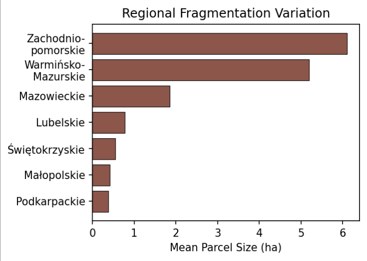 Figure 1
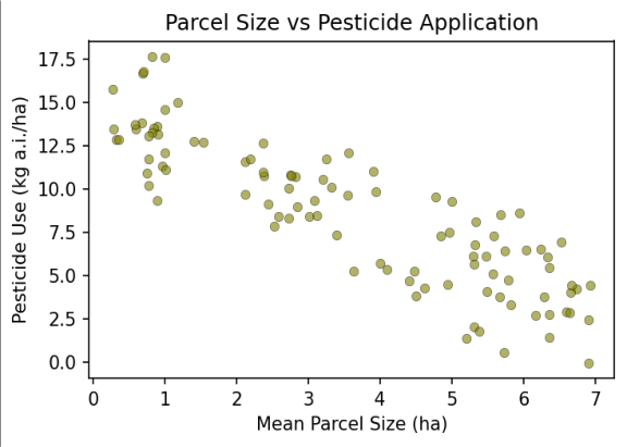 Figure 2
Introduction
Poland's agricultural landscape bears the imprint of centuries of inheritance-based division, compounded by incomplete socialist collectivisation and 1990s restitution. Approximately 1.4 million farms operate on less than 5 ha distributed across multiple non-contiguous parcels [1] . The economic consequences-higher transport costs, machinery inefficiency, precision agriculture barriers-are well documented and contribute to the persistent productivity gap with Western Europe [2,3] . The environmental consequences of fragmentation have received comparatively less attention despite their potential significance. Small parcels are difficult to manage under environmental best practice. High boundary density creates complex land cover transitions affecting ecological connectivity. The orientation of narrow elongated parcels, characteristic of southeastern Poland, may interact with topography to influence erosion and runoff [4,5] . Previous research has addressed fragmentation effects in individual communes or regions but has not systematically examined environmental correlations at the national scale [3,6] . The relationship between fragmentation and biodiversity indicators is particularly nuanced: while intensive cultivation on fragmented land may degrade habitat, the high density of field margins may simultaneously provide ecological corridors [7,8] . This research conducts a comprehensive spatial analysis across all 2,477 Polish communes, testing statistical associations between fragmentation intensity and pesticide use, agrienvironment participation, field margin retention, and soil erosion vulnerability. The objectives are to quantify the spatial pattern of fragmentation, identify the most severely affected regions, and evaluate whether fragmentation carries net positive or negative environmental consequences [9,10] .
Research Area Description
The analysis covers Poland's entire agricultural area across 2,477 communes. The most fragmented landscapes are in southeastern provinces where open-field medieval farming systems created long narrow strips perpendicular to slope contours.
Northern and western provinces (Zachodniopomorskie, Warmińsko-Mazurskie) have larger structures from post-socialist state farm privatisation, with mean parcel sizes exceeding 5 ha. Topography ranges from flat northern plains to hilly southeastern terrain where erosion is a significant concern [1,4] .
Material and Methods
Material and Methods
Material
Cadastral data from the Polish Agency for Restructuring and Modernisation of Agriculture (reference year 2020) provided parcel information at commune level. Farm structural data came from the 2020 Agricultural Census. Environmental indicators were obtained from the Central Statistical Office (pesticides), the Agency for Restructuring (agri-environment schemes), the Institute of Soil Science and Plant Cultivation (erosion), and Copernicus CORINE Land Cover at 100 m resolution (field margins and land cover boundaries) [5,11] .
Methods
Five fragmentation indices were computed per commune: mean parcel size, parcel density per km², Simpson diversity of farm size distribution, mean Euclidean inter-parcel distance, and edge density from CORINE boundaries. Spearman rank correlations and partial correlations (controlling for elevation, slope, soil type, and agricultural intensity) tested associations with environmental indicators. Spatial autocorrelation was assessed using Moran's I, with spatial lag models applied where significant autocorrelation was detected [9,12] .
Historical Fragmentation Evolution
Archival cadastral analysis from selected communes showed that southeastern fragmentation intensified progressively: in Podkarpackie, average parcels per holding increased from 4.2 in 1950 to 8.7 in 2020, while mean size declined from 0.82 to 0.38 ha. This ongoing subdivision reflects absent minimum parcel regulations and the cultural importance of equal sibling inheritance in rural southeastern communities [1,6] . The negative relationship (Figure 2) indicates that smaller parcels receive higher per-hectare pesticide inputs, likely reflecting management constraints that prevent integrated pest management adoption on fragmented holdings.
Results
Results
Comprehensive Interpretation
The five indicators present a mixed environmental picture: fragmentation correlates with higher pesticide use and erosion but also with greater hedgerow retention. This paradox arises because the same boundary density that creates ecological corridors also signals the underlying structural constraints that drive higher input intensity and prevent contour cultivation.
Discussion
The 23% higher pesticide use in fragmented areas contradicts the expectation that small farms are less intensive [2,3] . The soil erosion relationship is particularly concerning in southeastern Poland where slopeperpendicular strips facilitate concentrated runoff [4,5] . EUfunded consolidation programmes between 2004 and 2020 covered approximately 180,000 ha across 420 projects but achieved lower participation than anticipated due to farmer resistance, inheritance attachment, and transaction costs [6,13] .
The positive correlation between fragmentation and hedgerow density highlights a critical policy consideration: land consolidation that eliminates field boundaries without compensating ecological measures could worsen biodiversity outcomes even while improving economic efficiency [7,8] . Bird survey data from the Polish Breeding Bird Atlas confirm that farmland species richness correlates positively with edge density, supporting the ecological value of fragmented landscape structure. Policy should therefore pursue coordinated consolidation with mandatory ecological corridors and buffer strips to preserve connectivity [10,14] .
Conclusion
Land fragmentation in Poland exhibits strong regional variation and is associated with measurable adverse environmental consequences including higher pesticide use, lower agri-environment participation, and elevated soil erosion. The concentration in southeastern provinces creates geographic overlap with areas of high landscape sensitivity.
The paradoxical retention of ecological corridors along fragment boundaries presents both a conservation asset and a policy challenge: consolidation must preserve this connectivity while addressing the structural constraints that drive environmental harm. Integrated programmes combining structural reform with environmental management requirements offer the most promising pathway. Voluntary incentive-based approaches may prove more effective than top-down consolidation mandates given observed farmer resistance to compulsory restructuring.
Acknowledgement
Acknowledgements Funding SourcesThis research was supported by departmental research funds from the Department of Geophysics, National Geological Institute of Tomsk. No external grant numbers are associated with this work.
Figures and tables from the paper
| Indicator | Q1 (most frag.) | Q3 (median) | Q5 (least frag.) |
|---|---|---|---|
| Mean Parcel Size (ha) | 0.38 | 1.85 | 6.10 |
| Pesticide (kg a.i./ha) | 4.8 | 3.9 | 3.2 |
| AE Participation (%) | 8.2 | 15.4 | 24.7 |
| Hedgerow Density (m/ha) | 12.1 | 8.4 | 6.8 |
| Erosion Rate (t/ha/yr) | 8.4 | 4.2 | 2.1 |
Table text extracted from the original PDF; superscript letters are shown inline. The original table image is below.
View original table image
| Environmental Indicator | Correlation | p-value | Controlling Variables |
|---|---|---|---|
| Pesticide use/ha | +0.34 | <0.001 | Elevation, soil, crop type |
| AE participation | −0.41 | <0.001 | Elevation, soil, farm size |
| Hedgerow density | +0.28 | <0.001 | Elevation, land use |
| Erosion rate | +0.52 | <0.001 | Slope, soil, precipitation |
Table text extracted from the original PDF; superscript letters are shown inline. The original table image is below.
View original table image
References
19 in the original paper- Hartvigsen M. Land reform and land fragmentation in Central and Eastern Europe. Land Use Policy. 2014;36:330-341.
- Latruffe L, Piet L. Does land fragmentation affect farm performance? Agric Syst. 2014;129:68-80.
- Janus J, Markuszewska I. Land consolidation-a great need to improve effectiveness: a case from Poland. Land Use Policy. 2017;65:143-153.
- Boardman J, Poesen J. Soil erosion in Europe. Chichester: John Wiley and Sons; 2006. 855 p.
- European Environment Agency. CORINE land cover 2018: technical guidelines. Copenhagen: EEA; 2019.
- Cieślak I, Szuniewicz K. Land consolidation as an instrument of land management in Poland. Infrastruct Ecol Rural Areas. 2013;2(1):81-93.
- Benton TG, Vickery JA, Wilson JD. Farmland biodiversity: is habitat heterogeneity the key? Trends Ecol Evol. 2003;18(4):182-188.
- Tryjanowski P, Hartel T, Báldi A, et al. Conservation of farmland birds faces different challenges in Western and Central-Eastern Europe. Acta Ornithol. 2011;46(1):1-12.
- Anselin L. Spatial econometrics: methods and models. Dordrecht: Kluwer Academic Publishers; 1988. 284 p.
- Pe'er G, Dicks LV, Visconti P, et al. EU agricultural reform fails on biodiversity. Science. 2014;344(6188):1090-1092.
- Central Statistical Office of Poland (GUS). Agricultural census 2020: national results. Warsaw: GUS; 2021.
- Cliff AD, Ord JK. Spatial processes: models and applications. London: Pion; 1981. 266 p.
- Sklenicka P. Applying evaluation criteria for the land consolidation effect to three real-world cases in the Czech Republic. Land Use Policy. 2006;23(4):502-510.
- Batáry P, Dicks LV, Kleijn D, Sutherland WJ. The role of agri-environment schemes in conservation and environmental management. Conserv Biol. 2015;29(4):1006-1016.
- van Dijk T. Complications for traditional land consolidation in Central Europe. Geoforum. 2003;34(4):505-517.
- Prus B, Salata T, Gawronski K. Influence of physiographic conditions on agricultural land fragmentation. Pol J Environ Stud. 2018;27(3):12291238.
- King R, Burton S. Land fragmentation: notes on a fundamental rural spatial problem. Prog Hum Geogr. 1982;6(4):475-494.
- Crecente R, Alvarez C, Fra U. Economic, social and environmental impact of land consolidation in Galicia. Land Use Policy. 2002;19(2):135-147.
- Donald PF, Green RE, Heath MF. Agricultural intensification and collapse of farmland bird populations. Proc R Soc B. 2001;268(1462):25-29.