
Research article · 2025 · Full text
International Journal of Geography Geology and EnvironmentGeochemistry of lateritic weathering profiles over greenstone sequences in Western Australia
Volume 7(11) · Pages 133–136 · DOI: 10.22271/27067483.2025.v7.i11b.691 ↗
Research areasSoil and Environmental StudiesGeochemistry and Elemental AnalysisGeological and Geochemical Analysis
Abstract
Author-writtenLateritic weathering profiles over Archaean greenstone sequences in Western Australia extend to depths exceeding 100 m and represent some of the most deeply weathered terrains on Earth. These profiles host supergene gold and nickel enrichment of significant economic interest, and their geochemical evolution provides insights into long-term tropical weathering of mafic-ultramafic substrates. This research presents detailed geochemical profiles through lateritic regolith at four sites in the Eastern Goldfields Province overlying different greenstone lithologies: komatiitic ultramafic near Kambalda, basaltic volcanic east of Kalgoorlie, felsic volcanic near Norseman, and banded iron formation near Coolgardie. A total of 284 samples from reverse circulation drill holes were analysed by XRF, ICP-MS, XRD, and SEM. Results demonstrate systematic dissolution of primary silicates with residual enrichment of Al, Fe, Ti, and Cr. Nickel follows a characteristic pattern: depletion in upper laterite (<0.05 wt%), enrichment to 2.8 wt% in lower saprolite, and background values (~0.25 wt%) in fresh bedrock. Gold shows both residual concentration in ferruginous laterite (50–180 ppb) and secondary enrichment at the weathering front. Mass balance calculations using Ti as the immobile reference indicate 60–85% original rock mass removal, representing enormous dissolved material export over approximately 70 million years of weathering history.
Summary
Source-checkedPlain-language reading of the full paper, prepared with AI and checked against the text. Each point links to the authors' own words.
Why it matters
- Western Australia contains some of the world's most deeply weathered terrains, with lateritic profiles over Archaean greenstone sequences reaching depths of over 100 meters. View evidence ↗
- These weathering profiles are economically important because they host supergene enrichments of nickel and gold. View evidence ↗
- Studying the geochemistry of these profiles is critical for mineral exploration to help detect buried deposits beneath thick regolith cover. View evidence ↗
The question
- The study aims to document geochemical changes across complete profiles, quantify mass balance, and characterize the redistribution of elements like Ni, Co, Au, and REEs. View evidence ↗
What they did
- The research analyzed four sites in the Eastern Goldfields Province with different lithologies: komatiitic ultramafic, basaltic volcanic, felsic volcanic, and banded iron formation. View evidence ↗
- A total of 284 samples were collected at 1-meter intervals using reverse circulation drill holes to penetrate the full regolith profiles. View evidence ↗
- Analysis included wavelength-dispersive XRF for major elements, ICP-MS for trace elements, and fire assay with ICP finish for gold. View evidence ↗
- Mineralogy was analyzed via XRD and SEM-EDS, while mass balance was calculated using Ti-normalization to determine element gains and losses. View evidence ↗
What they found
- The results show that primary silicates were systematically dissolved, leading to the residual enrichment of Al, Fe, Ti, and Cr. View evidence ↗
- Nickel showed a distinct pattern of depletion in the upper laterite (<0.05 wt%), enrichment in the lower saprolite (2.8 wt%), and background levels in fresh bedrock (~0.25 wt%). View evidence ↗
- Gold in the ferruginous laterite cap reached 50–180 ppb, which is 3–12 times higher than the bedrock values of 8–15 ppb. View evidence ↗
- Mass balance calculations indicate that 60–85% of the original rock mass was removed over approximately 70 million years. View evidence ↗
- Cerium anomalies reached 2.4 in the mottled zone due to oxidative scavenging by iron oxyhydroxides. View evidence ↗
- The highest supergene enrichment factors occurred in komatiite, with Ni enriched 11.2×, Co 18.0×, Au 12.0×, and Cr 4.5×. View evidence ↗
What it means
- The authors conclude that the 2.8 wt% Ni enrichment in the lower saprolite confirms the economic potential of supergene processes on ultramafic substrates. View evidence ↗
- The established geochemical framework is intended to improve regolith exploration strategies on the Australian craton and aid the understanding of global landscape evolution. View evidence ↗
Visual summary
1 visualsIllustrations explain the paper; they do not show study data.
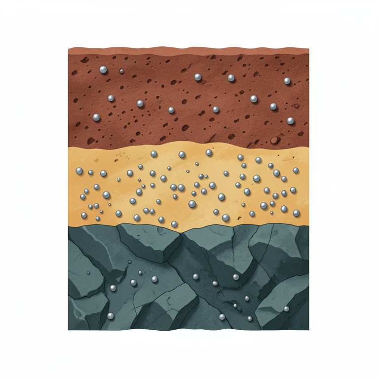
Nickel Distribution Profile
AI-generated conceptual illustration (lateritic weathering profile over greenstone bedrock). It explains the idea and does not show study data.
View source evidence ↗Figures & tables
From the original paper Table 1
 Table 2
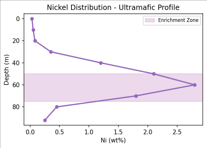 Figure 1
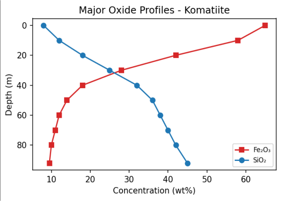 Figure 2
Introduction
The deeply weathered landscapes of the Western Australian shield represent one of the most extensive lateritic provinces on Earth, where prolonged exposure to tropical and subtropical conditions since the Mesozoic has produced regolith of extraordinary thickness and geochemical complexity [1] . These profiles are most extensively studied where they overlie greenstone belt sequences of the Yilgarn Craton, which host major gold and nickel deposits [2, 3] . Supergene enrichment-whereby metals originally disseminated at low concentrations in primary rocks are concentrated to economic grades by weathering solutions-has generated substantial nickel laterite deposits over ultramafic rocks and modified gold distributions in greenstone ore systems [4] . Understanding the geochemical processes within lateritic profiles is essential for mineral exploration, where regolith geochemistry is used to detect buried mineralisation through thick cover [1,5] . Despite decades of research, the relative importance of residual enrichment versus absolute enrichment by solution transport varies between elements and settings but has not been systematically quantified across different greenstone lithologies at a single research locality [3, 6] . Mass balance estimates of total weathering loss are available for relatively few profiles. Gold mobility mechanisms-physical residual concentration, thiosulphate or chloride dissolution, and biological mobilisation-continue to be debated [5,7] . This research addresses these questions through detailed geochemical profiling at four sites on different greenstone lithologies. The objectives are to document systematic geochemical changes through complete profiles, quantify mass balance using immobile element methods, and characterise supergene redistribution of Ni, Co, Au, and rare earth elements to support improved exploration strategies [8,9] .
Research Area Description
The four sites are located in the Eastern Goldfields Province on the Archaean Yilgarn Craton.
The present climate is semi-arid (250-300 mm/yr rainfall), but the profiles formed under wetter Mesozoic-Palaeogene conditions. All profiles exhibit characteristic lateritic zonation: ferruginous duricrust, mottled zone, upper saprolite, lower saprolite, and saprock grading to fresh bedrock. Drill depths ranged from 45 to 112 m, with the ultramafic profile at Kambalda being the thickest at 92 m [1,2] .
Material and Methods
Material and Methods
Material
Reverse circulation drill holes penetrated the full regolith profile at each site. Samples were collected at 1 m intervals yielding 284 samples total. The ultramafic profile was dominated by goethite-hematite-kaolinite in upper zones transitioning to nontronite-garnierite-serpentine with depth. Fresh komatiite bedrock was encountered below 88 m at the Kambalda site [1,4] .
Methods
Major elements were determined by wavelength-dispersive XRF on fused glass discs (precision <0.5% relative). Trace elements including Ni, Co, Cr, Au, and REE were measured by ICP-MS following four-acid digest. Gold was determined by fire assay with ICP finish on 50 g charges. Mineralogy was characterised by XRD on random powder mounts supplemented by SEM-EDS for textural and compositional analysis of weathering products. Mass balance calculations used the Ti-normalisation method of Grant [10] to quantify element gains and losses relative to fresh bedrock [6,9] .
Gold Mobility and Cerium Anomaly Development
Gold concentrations in the ferruginous laterite cap reached 50-180 ppb, representing 3-12 times enrichment over bedrock values of 8-15 ppb through residual mass loss concentration. A secondary enrichment peak at the weathering front in two profiles indicates dissolution by thiosulphate complexes in the upper profile and reprecipitation under reducing conditions [5,7] . Cerium anomalies reached 2.4 in the mottled zone through oxidative scavenging by iron oxyhydroxides, providing a sensitive redox indicator for distinguishing in-situ laterite from transported cover in exploration contexts [8] . The characteristic Ni depletion-enrichment-background pattern (Figure 1) reflects downward migration from dissolving olivine and serpentine, with fixation in secondary garnierite at the weathering front. The mirror-image relationship between SiO₂ and Fe₂O₃ (Figure 2) reflects progressive silicate dissolution upward through the profile with corresponding residual iron enrichment in the laterite cap.
Results
Results
Comprehensive Interpretation
The convergence of major oxide, trace element, mineralogical, and mass balance data provides a consistent picture of top-down chemical weathering modulated by element-specific mobility. The ultramafic substrate produces the most extreme weathering profile due to the high solubility of olivine-rich komatiite in acidic tropical groundwaters.
Discussion
The 2.8 wt% Ni enrichment in the lower saprolite over komatiite confirms the economic potential of supergene processes, consistent with global nickel laterite formation models [4,6] . The vertical separation between Co enrichment (in Mn-oxide zones) and Ni enrichment (in silicate zones) is diagnostic of supergene nickel laterite profiles worldwide and reflects the different geochemical behaviours of these elements under varying redox conditions [3,8] . The 85% mass loss at the laterite cap represents enormous dissolved material export over ~70 Myr. For the ultramafic profile, this equates to approximately 180 m of original rock column reduced to 92 m of regolith-a remarkable testament to the cumulative power of chemical weathering in stable cratonic settings [1,9] . The gold enrichment patterns support the use of laterite surface geochemistry for detecting buried primary mineralisation, but the dual enrichment mechanisms (residual and secondary) require careful interpretation in exploration applications [5,7,11,12] .
Conclusion
This research documented systematic element redistribution in lateritic profiles over four greenstone lithologies. Nickel enrichment to 2.8 wt% in the lower saprolite confirms the economic significance of supergene processes on ultramafic substrates. Mass balance calculations demonstrate 60-85% rock mass removal, representing a major geochemical flux from the continental surface over geological time. The dual gold enrichment pattern supports surface geochemical exploration strategies.
The geochemical framework provides a basis for improved regolith exploration strategies on the Australian craton and contributes to understanding long-term landscape evolution in stable cratonic settings globally.
Acknowledgement
Acknowledgements
Figures and tables from the paper
| Zone | Depth (m) | SiO₂ (wt%) | Fe₂O₃ (wt%) | Ni (wt%) | Mass Loss (%) |
|---|---|---|---|---|---|
| Laterite Cap | 0–8 | 8 | 65 | 0.03 | 85 |
| Mottled Zone | 8–22 | 15 | 48 | 0.05 | 78 |
| Upper Saprolite | 22–45 | 25 | 28 | 0.35 | 65 |
| Lower Saprolite | 45–75 | 35 | 15 | 2.80 | 48 |
| Saprock | 75–88 | 42 | 11 | 0.45 | 25 |
| Fresh Bedrock | 88–92 | 45 | 10 | 0.25 | 0 |
Table text extracted from the original PDF; superscript letters are shown inline. The original table image is below.
View original table image
| Element | Komatiite | Basalt | Felsic Volcanic | BIF |
|---|---|---|---|---|
| Ni | 11.2× | 3.8× | 1.2× | 0.8× |
| Co | 18.0× | 6.2× | 2.1× | 1.5× |
| Au | 12.0× | 8.4× | 5.6× | 4.2× |
| Cr | 4.5× | 2.8× | 0.9× | 1.1× |
Table text extracted from the original PDF; superscript letters are shown inline. The original table image is below.
View original table image
References
14 in the original paper- Anand RR, Paine MD. Regolith geology of the Yilgarn Craton: implications for exploration. Aust J Earth Sci. 2002;49(1):3-162.
- Butt CRM. Nickel laterites and bauxites. CSIRO exploration and mining report. 2007;1098R:44 p.
- Butt CRM, Cluzel D. Nickel laterite ore deposits: weathered serpentinites. Elements. 2013;9(2):123-128.
- Freyssinet P, Butt CRM, Morris RC. Ore-forming processes related to lateritic weathering. In: Economic geology 100th anniversary volume. 2005. p. 681-722.
- Gray DJ. Hydrogeochemistry in the Yilgarn Craton. Geochem Explor Environ Anal. 2001;1(3):253-264.
- Nesbitt HW, Wilson RE. Recent chemical weathering of basalts. Am J Sci. 1992;292(10):740-777.
- Reith F, Rogers SL, McPhail DC, Webb D. Biomineralisation of gold: biofilms on bacterioform gold. Science. 2006;313(5784):233-236.
- Brimhall GH, Dietrich WE. Constitutive mass balance relations between chemical composition, volume, density, porosity. Geochim Cosmochim Acta. 1987;51(3):567-587.
- Taylor SR, McLennan SM. The continental crust: its composition and evolution. Oxford: Blackwell; 1985. 312 p.
- Grant JA. The isocon diagram-a simple solution to Gresens' equation. Econ Geol. 1986;81(8):1976-1982.
- Rollinson HR. Using geochemical data: evaluation, presentation, interpretation. Harlow: Longman; 1993. 352 p.
- Smith RE, Perdrix JL, Parks TC. Burial metamorphism in the Hamersley Basin. J Petrol. 1982;23(1):75-102.
- Anand RR. Weathering history, landscape evolution and implications for exploration. CRC LEME open file report. 2005;193:44 p.
- Butt CRM, Zeegers H. Regolith exploration geochemistry in tropical and subtropical terrains. Amsterdam: Elsevier; 1992. 607 p.