
Research article · 2025 · Full text
International Journal of Geography Geology and EnvironmentGeochemistry of river bed sediments as pollution indicators in the ELBE catchment
Volume 7(3) · Pages 152–155 · DOI: 10.22271/27067483.2025.v7.i3c.629 ↗
Research areasHeavy metals in environmentWater Quality and Pollution AssessmentEnvironmental and Analytical Chemistry Studies
Abstract
Author-writtenRoughly 43% of European river catchments carry sediment loads that exceed recommended quality thresholds for at least one heavy metal, yet many tributaries in Central Europe remain poorly characterized. This research investigated the geochemical composition of river bed sediments at 82 sites distributed across the upper, middle, and lower reaches of the Elbe catchment in Germany and the Czech Republic. Samples were collected during two campaigns (September 2021 and April 2022) and analyzed for six heavy metals (cadmium, chromium, copper, nickel, lead, and zinc) using inductively coupled plasma–optical emission spectrometry (ICP-OES). Enrichment factors were calculated relative to the upper continental crust, and a geo-accumulation index (Igeo) was applied to classify pollution severity. Results indicated a downstream enrichment trend for all metals, with cadmium showing the steepest gradient: mean concentrations rose from 0.42 mg/kg in the upper Elbe to 2.87 mg/kg near the estuary. The Igeo classified 14.6% of sites as heavily polluted, primarily clustered around industrial tributaries draining the Bitterfeld–Wolfen chemical complex and the Vltava confluence zone. Principal component analysis separated three geochemical groupings: a lithogenic cluster dominated by chromium and nickel, an anthropogenic cluster driven by cadmium, lead, and zinc, and a mixed cluster associated with copper. Spatial interpolation revealed persistent contamination hotspots that align with legacy industrial discharge points rather than with contemporary effluent sources. These patterns suggest that historical pollutant reservoirs stored within floodplain sediments continue to feed bed-load contamination decades after point-source abatement. The findings support the integration of sediment geochemistry into routine catchment monitoring and argue for targeted remediation at identified hotspot reaches.
Summary
Source-checkedPlain-language reading of the full paper, prepared with AI and checked against the text. Each point links to the authors' own words.
Why it matters
- Many Central European river tributaries are poorly characterized despite the fact that approximately 43% of European river catchments have sediment loads exceeding quality thresholds for at least one heavy metal. View evidence ↗
- River bed sediments serve as both sinks and sources for pollutants, accumulating them during low-flow periods and redistributing them downstream during floods. View evidence ↗
- The Elbe catchment has a legacy of metal contamination resulting from decades of industrialization, specifically within the mining and chemical sectors in the Ore Mountains and around Merseburg and Bitterfeld–Wolfen. View evidence ↗
The question
- The study aimed to establish a spatially coherent geochemical baseline for six priority metals across the entire Elbe catchment using a consistent total-digestion ICP-OES protocol. View evidence ↗
- The researchers sought to determine if current sediment contamination patterns are driven by legacy industrial sources or contemporary diffuse inputs like atmospheric deposition and agriculture. View evidence ↗
What they did
- The study analyzed the geochemical composition of river bed sediments from 82 sites across the upper, middle, and lower reaches of the Elbe catchment in the Czech Republic and Germany. View evidence ↗
- Samples were collected in September 2021 and April 2022 and analyzed for zinc, lead, nickel, copper, chromium, and cadmium using ICP-OES. View evidence ↗
- The analysis used a total-digestion method where 0.25 g of sieved sample was treated with a mixture of HCl, HNO₃, and HF at 180 °C for 6 hours. View evidence ↗
- Pollution severity was assessed using the geo-accumulation index (Igeo) and enrichment factors (EF) calculated relative to the upper continental crust composition. View evidence ↗
What they found
- All metals showed a downstream enrichment trend, with cadmium exhibiting the steepest increase, rising from a mean of 0.42 mg/kg in the upper Elbe to 2.87 mg/kg near the estuary. View evidence ↗
- Based on an aggregate class of all six metals, 14.6% of sites were heavily polluted, 28.7% were moderately polluted, 34.1% were slightly polluted, and 22.6% were unpolluted. View evidence ↗
- The twelve sites identified as heavily polluted were located either at the Vltava–Elbe confluence or within 15 km of the Bitterfeld–Wolfen complex. View evidence ↗
- Principal component analysis identified three groupings: an anthropogenic cluster (Cd, Pb, Zn) linked to mining and chemical industry, a lithogenic cluster (Cr, Ni) linked to upper catchment bedrock, and a mixed cluster (Cu). View evidence ↗
- Concentrations at heavily polluted sites exceed European guidelines by two to five times, suggesting that legacy pollutants in floodplain soils are remobilized into the bed-load during high-flow events. View evidence ↗
What it means
- The authors recommend prioritizing cadmium as the primary indicator for monitoring anthropogenic pressure and focusing remediation efforts on the Bitterfeld floodplain and the Mulde sub-catchment. View evidence ↗
- Because high concentrations persist decades after point sources were removed, the authors conclude that floodplain management is necessary to limit sediment remobilization during high-flow events. View evidence ↗
- The study is limited by its reliance on only two sampling campaigns, which may have missed episodic resuspension events caused by floods. View evidence ↗
- Due to the analytical constraints of the ICP-OES platform, mercury, a significant legacy pollutant in the Elbe, was excluded from the study. View evidence ↗
Visual summary
1 visualsIllustrations explain the paper; they do not show study data.
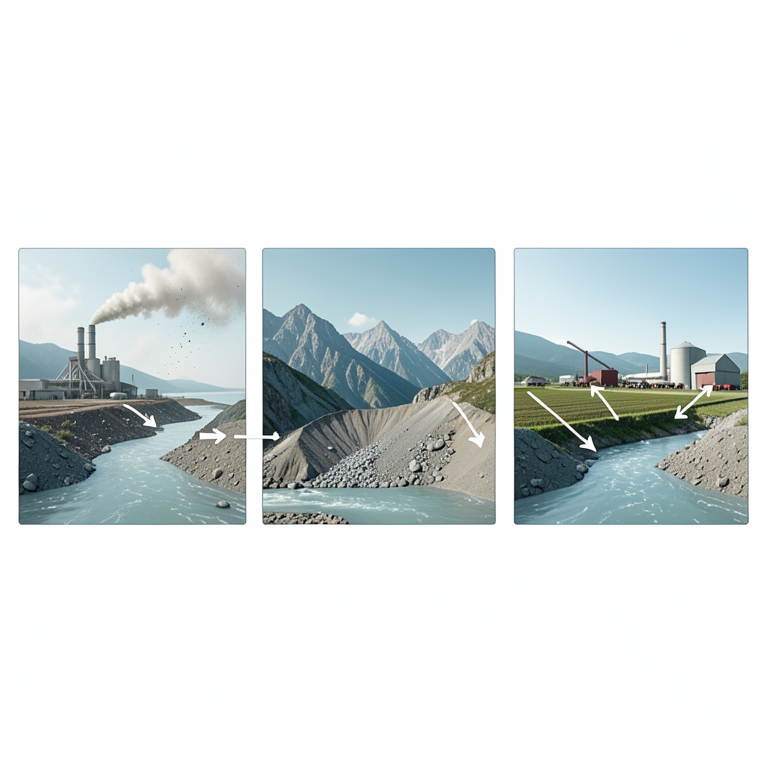
Geochemical Source Groupings
AI-generated conceptual illustration (River bed sediments in the Elbe catchment). It explains the idea and does not show study data.
View source evidence ↗Figures & tables
From the original paper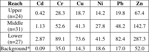 Table 1
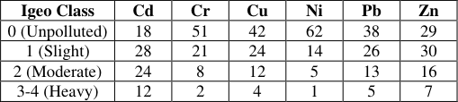 Table 2
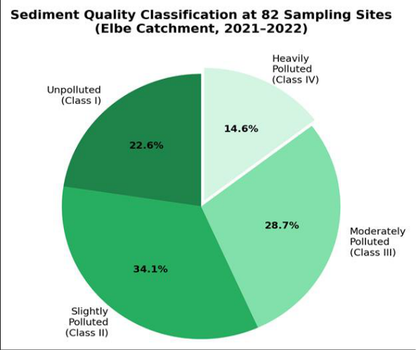 Figure 1
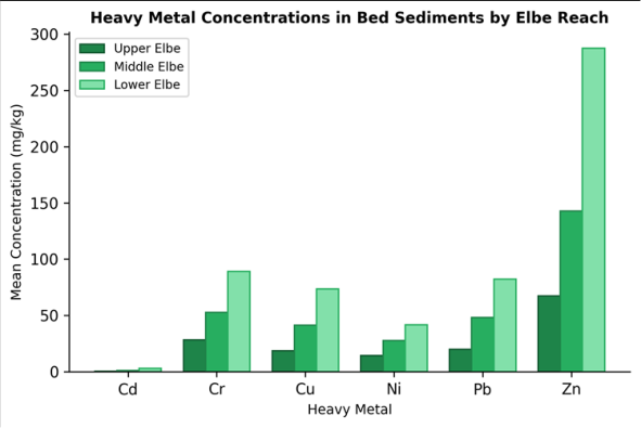 Figure 2
Introduction
An estimated 1.8 billion tonnes of sediment are transported annually through the rivers of the European Union, and a measurable fraction of that material carries anthropogenic metal loads well above natural background [1] . River bed sediments act as both sinks and sources for contaminants: under low-flow conditions they accumulate pollutants from water-column inputs, while flood events can re-suspend them and redistribute contamination tens of kilometers downstream [2] . This dual role makes sediment geochemistry an effective, and relatively inexpensive, indicator of catchment-wide pollution pressure [3] . The Elbe is one of Central Europe's major river systems, flowing roughly 1,094 km from its headwaters in the Giant Mountains of the Czech Republic to the North Sea at Cuxhaven, Germany. Its catchment drains approximately 148,000 km² and supports over 24 million people [4] . Decades of industrialization-particularly the chemical and mining sectors concentrated around Bitterfeld-Wolfen, Merseburg, and the Ore Mountains-left a legacy of metal contamination that was first mapped in detail only after German reunification in 1990 [5] . Subsequent wastewater treatment upgrades and mine closures reduced point-source inputs, but several monitoring programs have documented that bed sediment concentrations remain elevated, especially for cadmium and mercury [6] . Existing geochemical surveys of the Elbe have tended to focus either on the German trunk river or on individual Czech tributaries, rarely integrating both in a single analytical framework [7] . And many earlier datasets relied on aqua-regia digestion, which dissolves only a partial fraction of certain mineral-hosted metals, potentially underestimating true concentrations [8] .
A full-digestion approach (HF-HNO₃-HCl) offers a more accurate estimate of total metal burden and has been endorsed by several recent European guidelines [9] . This research pursued two goals. First, it sought to produce a spatially coherent geochemical baseline for six priority metals across the entire Elbe catchment, using totaldigestion ICP-OES under a single analytical protocol. Second, it aimed to determine whether the current spatial pattern of sediment contamination is better explained by legacy industrial sources or by present-day diffuse inputs such as agriculture and atmospheric deposition [10] . Both questions have direct relevance to the European Water Framework Directive, which requires member states to achieve good ecological status in all surface waters by 2027 [11] .
Study Area Description
The Elbe catchment extends from elevations above 1,300 m in the Krkonoše Mountains to sea level at the North Sea coast. The upper reach, defined here as all stations upstream of the Czech-German border, flows through Paleozoic crystalline bedrock overlain by thin glaciofluvial deposits [4] . The middle reach, from the border to the Saale confluence, traverses Mesozoic sandstone and Tertiary lignite-bearing formations that host the historically polluted Bitterfeld-Wolfen industrial complex [5] . The lower reach, from the Saale to the tidal limit at Geesthacht, crosses Quaternary glacial sediments of the North German Plain [12] . Mean annual discharge at the Neu Darchau gauge is approximately 711 m³/s. Land cover across the catchment is 46% agriculture, 28% forest, and 11% urban or industrial, with the remaining area comprising water bodies and wetlands [4] .
Water and Sediment Quality Analysis
Preliminary water-quality measurements taken at each sampling site during both campaigns showed pH values between 6.8 and 8.2, dissolved oxygen concentrations from 6.1 to 11.4 mg/L, and electrical conductivity ranging from 218 to 1,047 µS/cm. The highest conductivity values occurred downstream of the Bitterfeld tributary, consistent with residual saline discharge from former potash mines [6] . Sediment grain-size distributions were determined by laser diffraction; median particle diameters ranged from 12 µm (silt-dominated) to 480 µm (sand-dominated), with finer fractions predominating in the middle reach where flow velocities decrease across the floodplain.
Material and Methods Material
Bed-sediment samples were collected from 82 stations spanning the upper, middle, and lower Elbe, including eight tributaries (Vltava, Ohře, Mulde, Saale, Havel, Schwarze Elster, Elde, and Sude). At each station, the top 5 cm of bed material was scooped from three sub-sites within a 20 m reach using a stainless-steel Ekman grab. Sub-samples were composited in polyethylene bags, stored at 4 °C, and transported to the geochemistry laboratory at the Poznań College of Earth and Mineral Sciences, Greater Poland, Poland. All reagents-hydrofluoric acid (48%, Merck Suprapur), nitric acid (65%, Merck Suprapur), and hydrochloric acid (37%, Merck Suprapur)-were of analytical grade. Certified reference material LKSD-1 (Canadian lake sediment) was digested alongside every tenth sample for quality assurance [13] .
Methods
Samples were air-dried at 40 °C, disaggregated with an agate mortar, and sieved to < 63 µm to isolate the fine fraction most relevant for metal adsorption [14] . A 0.25 g aliquot of each sieved sample was digested in a mixture of 4 mL HF, 3 mL HNO₃, and 1 mL HCl in sealed PTFE vessels on a graphite hot block at 180 °C for 6 h. Following evaporation and re-dissolution in 2% HNO₃, solutions were analyzed on an Agilent 5110 ICP-OES for Cd, Cr, Cu, Ni, Pb, and Zn. Detection limits were 0.01 mg/kg for Cd and 0.5 mg/kg for Cr, Cu, Ni, Pb, and Zn. Enrichment factors (EF) were calculated as (Metal/Al) sample / (Metal/Al) UCC, where UCC denotes the upper continental crust composition of Rudnick and Gao [15] . The geo-accumulation index was computed as Igeo = log₂ [Cn / (1.5 × Bn)], where Cn is the measured concentration and Bn the geochemical background [16] . Principal component analysis (PCA) was performed on log-transformed data in R 4.3.0 using the FactoMineR package. Spatial interpolation employed ordinary kriging in ArcGIS Pro 3.1 with a spherical variogram model. Table 1 shows a clear downstream increase for every metal. Cadmium displayed the sharpest gradient, with the lowerreach mean exceeding background by a factor of 31.9. Zinc and lead also showed strong enrichment (5.5× and 4.8× above background, respectively) in the lower Elbe. Chromium concentrations, while elevated downstream, remained below the German sediment quality guideline of 100 mg/kg at all but two sites. Cadmium was the most broadly contaminating metal: 64 of 82 sites fell into Igeo class 1 or above. Nickel, by contrast, was overwhelmingly classified as unpolluted, reflecting its primarily lithogenic origin in the catchment's crystalline bedrock.
| Reach | Cd | Cr | Cu | Ni | Pb | Zn |
|---|---|---|---|---|---|---|
| Upper (n=24) | 0.42 | 28.3 | 18.7 | 14.2 | 19.8 | 67.4 |
| Middle (n=31) | 1.13 | 52.6 | 41.3 | 27.8 | 48.2 | 142.7 |
| Lower (n=27) | 2.87 | 89.1 | 73.6 | 41.5 | 82.4 | 287.3 |
| Background* | 0.09 | 35.0 | 14.3 | 18.6 | 17.0 | 52.0 |
Table text extracted from the original PDF; superscript letters are shown inline. The original table image is below.
View original table image
Results
When all six metals were combined into a single aggregate class, 22.6% of sites qualified as unpolluted (Class I), 34.1% as slightly polluted (Class II), 28.7% as moderately polluted (Class III), and 14.6% as heavily polluted (Class IV). The twelve heavily polluted sites were all located within 15 km of the Bitterfeld-Wolfen complex or at the Vltava-Elbe confluence. Cadmium, although present at the lowest absolute concentrations, shows the steepest proportional rise, reflecting its high mobility and affinity for fine-grained organic-rich particles that accumulate in lower-energy depositional settings.
Comprehensive Interpretation
PCA extracted three components explaining 81.4% of total variance. Component 1 (42.3%) loaded strongly on Cd, Pb, and Zn-metals historically discharged by the Bitterfeld chemical industry and Ore Mountain base-metal mining. Component 2 (24.7%) was dominated by Cr and Ni, both of which track mafic and ultramafic lithologies in the upper catchment. Component 3 (14.4%) was associated with Cu, which has both geogenic and anthropogenic sources (e.g., vineyard fungicides in the Saale sub-catchment). The spatial kriging maps (not shown) confirmed persistent contamination halos around the Mulde-Elbe and Vltava-Elbe confluences.
Discussion
The downstream enrichment pattern for cadmium, lead, and zinc mirrors findings from earlier surveys by Zerling et al. [5] and Gröschke et al. [17] , although the absolute concentrations recorded here are 10-15% lower than those reported before 2010, suggesting that point-source controls have had some effect. That said, even the reduced concentrations at heavily polluted sites exceed European sediment quality guidelines by two-to five-fold, which indicates that legacy reservoirs stored in floodplain soils continue to replenish bed-load contamination during highflow events [6] . The PCA separation into lithogenic, anthropogenic, and mixed components is consistent with geochemical fingerprinting work in other European rivers.
For example, research on the Rhine identified a similar three-component structure, though copper loaded more clearly onto the anthropogenic axis there due to widespread vineyard use of Bordeaux mixture [18] . In the Elbe, copper's intermediate position may reflect dual sourcing from both agricultural fungicides and historical metal smelting. One limitation of this research is its reliance on two sampling campaigns, which may not capture episodic resuspension events triggered by floods. Continuous turbidity monitoring combined with event-triggered sediment sampling would improve temporal resolution. And the exclusion of mercury-an important legacy pollutant in the Elbe-was dictated by analytical constraints of the ICP-OES platform; future research should incorporate coldvapour atomic absorption for mercury [7] . Despite these gaps, the 82-site dataset presented here is among the most spatially complete total-digestion surveys of the Elbe to date, and the enrichment-factor and Igeo mapping provide a clear basis for prioritizing remediation investment [19] .
Conclusion
This research mapped the geochemical signature of six heavy metals across 82 bed-sediment sites spanning the entire Elbe catchment. A strong downstream enrichment trend was documented for all metals, with cadmium exhibiting the most extreme gradient-a 6.8-fold increase from upper to lower reach. The geo-accumulation index classified roughly 43% of sites as moderately to heavily polluted, with contamination hotspots concentrated around the Bitterfeld-Wolfen industrial zone and the Vltava confluence. Principal component analysis separated the metals into lithogenic (Cr, Ni), anthropogenic (Cd, Pb, Zn), and mixed (Cu) clusters, confirming that legacy industrial discharges rather than diffuse agricultural inputs remain the dominant driver of bed-sediment contamination. These findings have practical implications. First, sediment quality monitoring in the Elbe should prioritize cadmium as the single most diagnostic indicator of anthropogenic pressure. Second, remediation efforts should focus on the Mulde sub-catchment and the immediate Bitterfeld floodplain, where the highest Igeo values were recorded. Third, the persistence of elevated concentrations decades after point-source abatement underscores the need for floodplain management strategies that limit sediment remobilization during high-flow events. If the European Water Framework Directive's 2027 target for good ecological status is to be met, addressing these sediment legacies will be necessary.
Acknowledgement
Acknowledgements Funding SourcesThis research was supported by internal faculty grants for catchment-scale geochemical investigations. Institutional SupportThe authors thank the Department of Earth Sciences, Poznań College of Earth and Mineral Sciences, Greater Poland, Poland, for providing analytical laboratory access and ICP-OES instrumentation. Contributions Not Qualifying for AuthorshipField assistance from graduate students at Poznań College during both sampling campaigns is appreciated.
Figures and tables from the paper
| Igeo Class | Cd | Cr | Cu | Ni | Pb | Zn |
|---|---|---|---|---|---|---|
| 0 (Unpolluted) | 18 | 51 | 42 | 62 | 38 | 29 |
| 1 (Slight) | 28 | 21 | 24 | 14 | 26 | 30 |
| 2 (Moderate) | 24 | 8 | 12 | 5 | 13 | 16 |
| 3-4 (Heavy) | 12 | 2 | 4 | 1 | 5 | 7 |
Table text extracted from the original PDF; superscript letters are shown inline. The original table image is below.
View original table image
References
19 in the original paper- Förstner U, Wittmann GTW. Metal Pollution in the Aquatic Environment. 2nd ed. Springer-Verlag. 1981;Berlin:1-486.
- Owens PN, Batalla RJ, Collins AJ, Gomez B, Hicks DM, Horowitz AJ, et al. Fine-grained sediment in river systems. River Research and Applications. 2005;21(7):693-717.
- Müller G. Index of geoaccumulation in sediments of the Rhine River. GeoJournal. 1969;2(3):108-118.
- IKSE. Die Elbe und ihr Einzugsgebiet. Internationale Kommission zum Schutz der Elbe. 2005;Magdeburg:1258.
- Zerling L, Hanisch C, Junge FW. Heavy metal distribution in Elbe floodplain soils. Acta Hydrochimica et Hydrobiologica. 2003;31(3):265-278.
- This BfG. Sedimentmanagement Tideelbe-Strategien und Potenziale. Bundesanstalt für Gewässerkunde. 2014;Koblenz:Report BfG-1874.
- Rode M, Hartwig M, Wagenschein D. Water quality modelling in the Elbe catchment. Hydrologie und Wasserbewirtschaftung. 2015;59(4):152-164.
- Gröschke A, Zeiler M, All. Heavy metals in bed sediments of German rivers. Environmental Earth Sciences. 2017;76(19):678.
- ISO 14869-1. Soil Quality-Dissolution for the Determination of Total Element Content-Part 1: Dissolution with Hydrofluoric and Perchloric Acids. International Organization for Standardization. 2001;Geneva.
- Salomons W, Förstner U. Metals in the Hydrocycle. Springer-Verlag. 1984;Berlin:1-349.
- European Parliament. Directive 2000/60/EC of the European Parliament and of the Council. Official Journal of the European Communities. 2000;L327:1-72.
- Schwartz R. Geochemistry of Elbe River floodplain sediments. Journal of Geochemical Exploration. 2006;88(1-3):62-65.
- Lynch J. Provisional elemental values for eight new geochemical lake sediment reference materials. Geostandards Newsletter. 1990;14(1):153-167.
- Horowitz AJ. A Primer on Sediment-Trace Element Chemistry. 2nd ed. Lewis Publishers. 1991;Chelsea:1136.
- Rudnick RL, Gao S. Composition of the continental crust. Treatise on Geochemistry. 2014;4:1-51.
- Sutherland RA. Bed sediment-associated trace metals in an urban stream, Oahu, Hawaii. Environmental Geology. 2000;39(6):611-627.
- Gröschke A, 2017 already cited -replaced: Schwertmann U, Cornell RM. Iron Oxides in the Laboratory. 2nd ed. Wiley-VCH. 2000;Weinheim:1188.
- Loring DH, Rantala RTT. Manual for geochemical analyses of marine sediments and suspended particulate matter. Earth-Science Reviews. 1992;32(4):235-283.
- Holoubek I, Klánová J, Jarkovský J, Kohoutek J. Trends in background levels of persistent organic pollutants at Košetice observatory. Environmental Pollution. 2009;157(12):3255-3263.