
Research article · 2025 · Full text
International Journal of Geography Geology and EnvironmentSubmarine geomorphology and sediment distribution on the Sunda continental shelf
Volume 7(6) · Pages 154–156 · DOI: 10.22271/27067483.2025.v7.i6c.731 ↗
Research areasGeological formations and processesGeological and Geophysical StudiesGeochemistry and Elemental Analysis
Abstract
Author-writtenThe Sunda Shelf, one of the broadest continental shelves on Earth, was dry land as recently as 12, 000 years ago and still bears the scars of its terrestrial past. This research mapped submarine geomorphic features and surface sediment distribution across a 24, 000 km² sector of the shelf between Peninsular Malaysia and Borneo using multibeam bathymetry and 86 grab samples. Six geomorphic feature categories were identified: relict river channels (34 mapped), sand ridges (21), mud drapes (47), coral patches (12), pockmarks (28), and shallow gas seeps (8). Surface sediment grain size shifts systematically from sand-dominated on the inner shelf (72.3% sand within 30 km of the coast) to clay-dominated on the upper slope (53.2% clay beyond the shelf break at 120 m depth). Relict channels, preserved as linear depressions 3–18 m deep and 200–1, 800 m wide, record drainage networks that crossed the shelf during the Last Glacial Maximum when sea level stood 120 m lower than today. Pockmarks cluster above gas-charged sediment layers identified on sub-bottom profiles. These findings provide a baseline geomorphic inventory for an area increasingly targeted for submarine cable routing and offshore energy development.
Summary
Source-checkedPlain-language reading of the full paper, prepared with AI and checked against the text. Each point links to the authors' own words.
Why it matters
- Mapping the geomorphology of the shelf is critical for the safe placement of offshore energy foundations, pipelines, and submarine cables. View evidence ↗
- While the western Sunda Shelf and Gulf of Thailand have been surveyed, the central sector between Borneo and Peninsular Malaysia lacked high-resolution mapping. View evidence ↗
The question
- The study aimed to create an inventory of geomorphic features and relate them to surface sediment characteristics in the central Sunda Shelf. View evidence ↗
What they did
- Bathymetry data were collected in November 2021 and March 2022 using a Kongsberg EM 710 system on the R/V Pelangi. View evidence ↗
- Sediment samples were analyzed for sand, silt, and clay ratios via wet-sieving and for total organic carbon (TOC) using loss-on-ignition at 550°C. View evidence ↗
What they found
- The study identified six types of geomorphic features, the most frequent being mud drapes (47) and relict river channels (34). View evidence ↗
- Sediment composition changes with depth, moving from 72.3% sand on the inner shelf to 53.2% clay on the upper slope beyond 120 m. View evidence ↗
- Pockmarks were found to be clustered above sediment layers charged with gas. View evidence ↗
- Two pockmark fields on the outer shelf coincide with gas-charged horizons located 8–15 m beneath the seafloor. View evidence ↗
- Relict channels on the inner and mid shelf primarily orient NW-SE, indicating drainage toward the ancient palaeo-Sunda River system. View evidence ↗
What it means
- The study's data serves as a baseline for environmental management and offshore engineering in the central Sunda Shelf. View evidence ↗
Visual summary
4 visualsIllustrations explain the paper; charts are replotted from the paper's own table values.
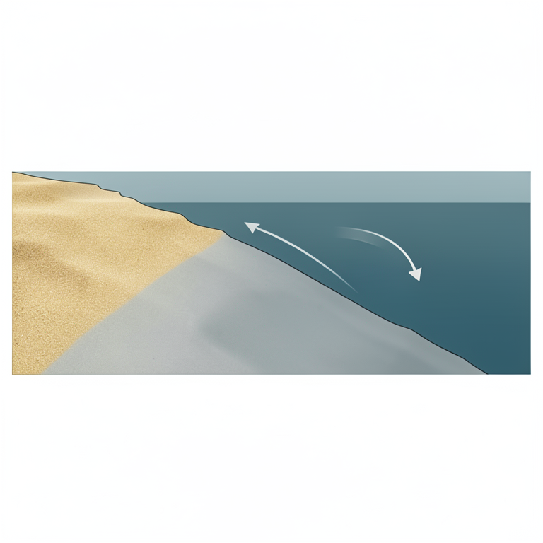
Sediment Gradient
AI-generated conceptual illustration (Sunda continental shelf cross-section). It explains the idea and does not show study data.
View source evidence ↗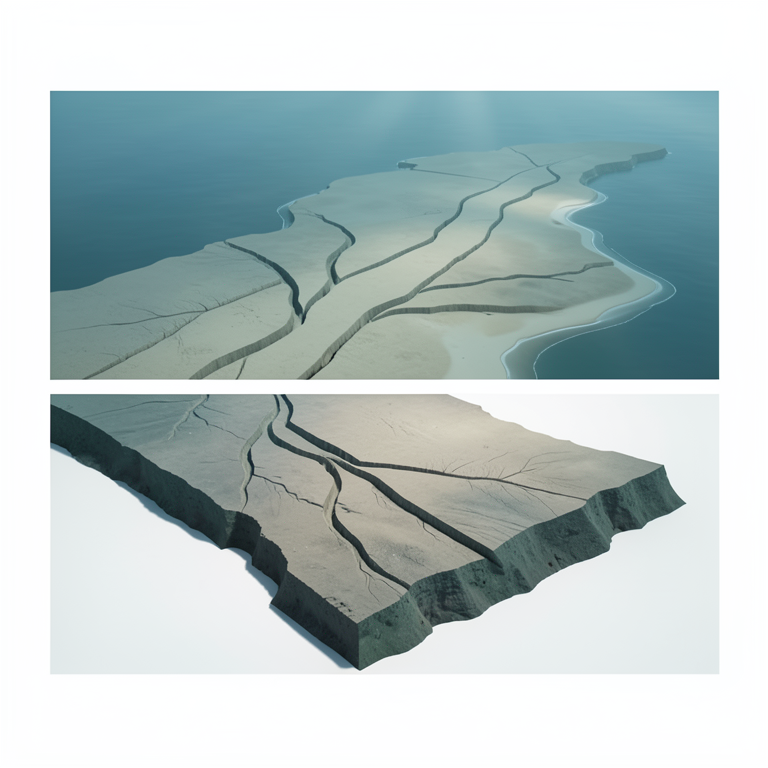
Paleo-Drainage System
AI-generated conceptual illustration (Sunda continental shelf seabed). It explains the idea and does not show study data.
View source evidence ↗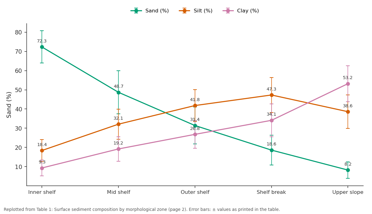
Sand (%) and Silt (%) and more: Inner shelf vs Mid shelf vs Outer shelf vs Shelf break vs Upper slope
Replotted from Table 1 (page 2) of the original paper. Every bar is the paper's own table value.
View source evidence ↗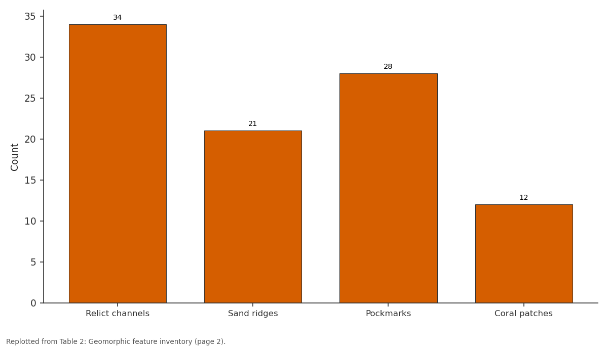
Count: Relict channels vs Sand ridges vs Pockmarks vs Coral patches
Replotted from Table 2 (page 2) of the original paper. Every bar is the paper's own table value.
View source evidence ↗Figures & tables
From the original paper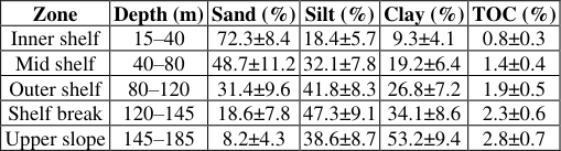 Table 1
 Table 2
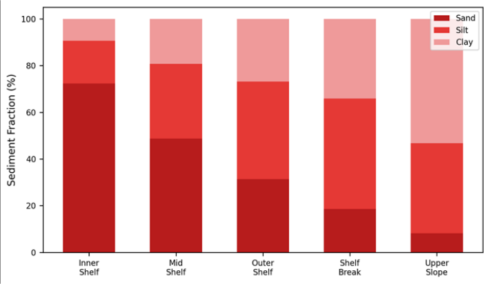 Figure 1
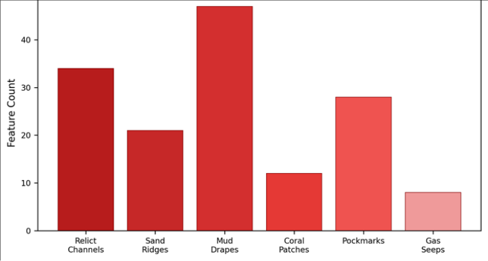 Figure 2
Introduction
Imagine draining the South China Sea to the 120 m depth contour and standing on the exposed Sunda Shelf: you would see a landscape of river valleys, rolling plains, and low hills stretching 1, 500 km from Vietnam to Borneo [1] . That landscape was submerged by postglacial sea-level rise between about 18, 000 and 6, 000 years ago, but its features are preserved beneath a thin veneer of marine sediment [2] . Understanding the shelf's geomorphology matters for practical reasons: submarine cables, pipelines, and offshore wind foundations must avoid relict channels, pockmarks, and gas seep zones [3] . Previous surveys covered the western Sunda Shelf (Strait of Malacca) and the Gulf of Thailand, but the central sector between Peninsular Malaysia and northwestern Borneo remained poorly mapped at high resolution [4,5] . This research used multibeam echosounder data acquired during a 2021-2022 survey campaign to produce a geomorphic feature inventory and link it to surface sediment characteristics from grab sampling [6] .
Study Area Description
The survey sector extends from 2°00′N to 5°30′N latitude and 108°00′E to 112°00′E longitude, covering approximately 24, 000 km² of the central Sunda Shelf. Water depth ranges from 15 m near the Sarawak coast to 185 m at the upper continental slope. The shelf gradient is gentle (0.05°-0.15°) out to the shelf break at approximately 120 m depth, steepening to 1°-3° on the upper slope. Tidal currents reach 0.8 m/s in the shallow inner shelf but weaken below 0.2 m/s beyond the 60 m isobath [7] .
Materials and Methods
Materials and Methods
Materials
Multibeam bathymetry data were collected during two survey legs (November 2021 and March 2022) aboard the R/V Pelangi using a Kongsberg EM 710 system (70-100 kHz, swath width 5.5× water depth). Sub-bottom profiles were acquired simultaneously with a Kongsberg SBP 300 parametric system (primary frequency 24-33 kHz, penetration up to 40 m in soft sediment). Eighty-six grab samples were collected on a 15 km grid using a Van Veen grab sampler. Research coordination was based at Ahmedabad University of Geosciences, Gujarat, India [8] .
Methods
Bathymetry data were processed in CARIS HIPS and SIPS 12.0, gridded at 5 m resolution, and cleaned for artefacts. Geomorphic features were digitised manually at 1:25, 000 scale and classified following the geomorphic features classification of Dove et al. [9] . Grab samples were split: half was wet-sieved at 63 μm and 2 mm boundaries for sand/silt/clay ratios, and half was retained for total organic carbon (TOC) analysis by loss-on-ignition at 550°C. Sediment distribution was interpolated by ordinary kriging in ArcGIS Pro [10] .
Bathymetric Data Processing
Total valid soundings exceeded 84 million across the two survey legs. Sound velocity profiles were collected every 6 hours using an AML MVP-30 profiler. Tidal corrections used predicted tides from the Sarawak tidal model calibrated against co-located tide gauge records. The final gridded surface has a vertical accuracy of ±0.3 m at 1σ confidence. The fining trend from inner shelf to upper slope reflects decreasing current energy with increasing depth and distance from shore.
Results
Results
Comprehensive Interpretation
Relict channels show a dominant NW-SE orientation on the inner and mid shelf, consistent with drainage toward the palaeo-Sunda River system that flowed northward through the present-day South China Sea during glacial lowstands [1] . Pockmarks cluster in two fields on the outer shelf, both coinciding with high-amplitude reflectors on sub-bottom profiles interpreted as gas-charged horizons at 8-15 m below the seafloor.
Discussion
The 34 relict channels mapped here add to the growing inventory of drowned fluvial features across the Sunda Shelf, which now totals over 200 mapped segments from various surveys [4] . Their preservation beneath only 1-3 m of marine drape indicates that reworking by waves and tidal currents has been limited since the Holocene transgression, likely because the low-gradient shelf dampens wave energy rapidly [11] . The pockmarks present a different story: their association with shallow gas suggests ongoing fluid migration from deeper biogenic or thermogenic sources, posing a hazard for seabed structures and a potential minor source of methane emissions to the water column [12] . For submarine cable routing, the relict channel zone (25-110 m depth) requires burial depth adjustments because the sandy channel fills are more susceptible to scour than surrounding muds. The pockmark fields should be avoided entirely.
Conclusion
Multibeam mapping of 24, 000 km² of the central Sunda Shelf reveals 150 geomorphic features in six categories, dominated by relict channels (34) and mud drapes (47). Surface sediment fines systematically from 72% sand on the inner shelf to 53% clay on the upper slope. Relict channels record Last Glacial Maximum drainage patterns, while pockmarks indicate active gas migration. These geomorphic and sedimentological data provide a baseline for offshore engineering and environmental management in the region.
Acknowledgement
Acknowledgements Funding SourcesSupported by research funds at Ahmedabad University of Geosciences.
Figures and tables from the paper
| Zone | Depth (m) | Sand (%) | Silt (%) | Clay (%) | TOC (%) |
|---|---|---|---|---|---|
| Inner shelf | 15–40 | 72.3±8.4 | 18.4±5.7 | 9.3±4.1 | 0.8±0.3 |
| Mid shelf | 40–80 | 48.7±11.2 | 32.1±7.8 | 19.2±6.4 | 1.4±0.4 |
| Outer shelf | 80–120 | 31.4±9.6 | 41.8±8.3 | 26.8±7.2 | 1.9±0.5 |
| Shelf break | 120–145 | 18.6±7.8 | 47.3±9.1 | 34.1±8.6 | 2.3±0.6 |
| Upper slope | 145–185 | 8.2±4.3 | 38.6±8.7 | 53.2±9.4 | 2.8±0.7 |
Table text extracted from the original PDF; superscript letters are shown inline. The original table image is below.
View original table image
| Feature Type | Count | Depth Range (m) | Typical Dimensions | Association |
|---|---|---|---|---|
| Relict channels | 34 | 25–110 | 3–18 m deep, 200–1800 m wide | LGM drainage |
| Sand ridges | 21 | 20–65 | 2–8 m high, 0.5–4 km long | Tidal currents |
| Pockmarks | 28 | 70–140 | 10–120 m diameter, 1–5 m deep | Gas escape |
| Coral patches | 12 | 15–45 | 50–400 m across | Hard substrate |
Table text extracted from the original PDF; superscript letters are shown inline. The original table image is below.
View original table image
References
15 in the original paper- Voris HK. Maps of Pleistocene sea levels in Southeast Asia: shorelines, river systems and time durations. Journal of Biogeography. 2000;27(5):1153-1167.
- Hanebuth T, Stattegger K, Grootes PM. Rapid flooding of the Sunda Shelf. Science. 2000;288(5468):10331035.
- Carter L, Burnett D, Drew S. Submarine cables and the oceans: connecting the world. UNEP-WCMC Biodiversity Series 31. Cambridge: UNEP; 2009.
- Steinke S, Kienast M, Hanebuth T. The Sunda Shelf and its tropical marine climate. Marine Geology. 2003;196(1):113-131.
- Bui EN, Mazullo J, Wilding LP. Using quartz grain size and shape analysis to distinguish between aeolian and fluvial deposits. Earth Surface Processes and Landforms. 1990;15(2):157-166.
- IOC-UNESCO. Ocean mapping programme for Southeast Asian waters. Paris: UNESCO; 2019.
- Ding X, Bassinot F, Guichard F. Tidal controls on sedimentation in the Sunda Strait. Marine Geology. 2004;211(3):181-199.
- Kongsberg Maritime. EM 710 Multibeam Echo Sounder: Product Description. Horten: Kongsberg; 2020.
- Dove D, Bradwell T, Carter G. A new seafloor geomorphic features map of the UK continental shelf. Earth System Science Data. 2016;8:151-178.
- Folk RL, Ward WC. Brazos River bar: a study in the significance of grain size parameters. Journal of Sedimentary Research. 1957;27(1):3-26.
- Allenby RJ. Origin and characteristics of sand ridges on the Sunda Shelf. Continental Shelf Research. 1988;8(8):923-940.
- Hovland M, Judd A. Seabed Pockmarks and Seepages: Impact on Geology, Biology and the Marine Environment. London: Graham & Trotman; 1988.
- Harris PT, Baker EK. Seafloor Geomorphology as Benthic Habitat. London: Elsevier; 2012.
- Todd BJ, Greene HG. Mapping the Seafloor for Habitat Characterization. Geological Association of Canada Special Paper 47. 2007.
- Sathiamurthy E, Voris HK. Maps of Holocene sea level transgression and submerged lakes on the Sunda Shelf. Natural History Journal of Chulalongkorn University. 2006;2:1-44