
Research article · 2025 · Full text
International Journal of Geography Geology and EnvironmentSedimentary facies analysis and basin evolution of the Mesozoic Sichuan formation
Volume 7(6) · Pages 102–105 · DOI: 10.22271/27067483.2025.v7.i6b.696 ↗
Research areasGeological formations and processesHydrocarbon exploration and reservoir analysisGeological and Geophysical Studies
Abstract
Author-writtenThe Sichuan Basin in southwestern China preserves one of Asia's thickest and most complete Mesozoic sedimentary successions, yet the facies architecture and depositional controls on its Triassic-to-Cretaceous fill remain debated. This research described and interpreted sedimentary facies from five measured outcrop sections totalling 1,480 m of stratigraphy along the basin's eastern margin. Ten facies were grouped into four facies associations: fluvial channel, floodplain, lacustrine, and shallow marine carbonate. Sandstone-dominated intervals thin upward from 42% of unit thickness in the Triassic to 18% in the Cretaceous, while fine-grained lacustrine and carbonate deposits expand correspondingly. Palaeocurrent data from 87 cross-bed measurements indicate a consistent west-to-east transport direction. The vertical facies succession records a transition from marine carbonate platform (Late Triassic) through terrestrial fluvial-lacustrine systems (Jurassic) to a broad, low-energy lake basin (Early Cretaceous), driven by the interplay of tectonic subsidence along the Longmen Shan thrust belt and eustatic sea-level change.
Summary
Source-checkedPlain-language reading of the full paper, prepared with AI and checked against the text. Each point links to the authors' own words.
Why it matters
- The Sichuan Basin in southwestern China is a significant geological area covering about 180,000 km², with Mesozoic sedimentary layers reaching over 5,000 m in thickness near the Longmen Shan front. View evidence ↗
- The basin's deposits are of high economic value because they house major gas reservoirs within tight sandstones and Triassic carbonates. View evidence ↗
- There is a knowledge gap regarding the vertical and lateral changes in sedimentary facies along the eastern margin of the basin, which are critical for understanding reservoir architecture. View evidence ↗
The question
- The study aims to define sedimentary facies and associations, document the vertical stratigraphic succession, and determine how tectonic and eustatic controls influenced these changes along the eastern margin. View evidence ↗
What they did
- Researchers measured five outcrop sections (EC-1 to EC-5) using a Jacob's staff and Abney level, covering a total stratigraphic thickness of 1,480 m. View evidence ↗
- The methodology included the collection of 142 hand samples for petrographic analysis and 87 palaeocurrent measurements from cross-bedded sandstones. View evidence ↗
- Sedimentary facies were classified using the Miall scheme for clastic deposits and the Dunham scheme for carbonate deposits. View evidence ↗
- The age of the stratigraphic units was determined using regional correlation charts based on bivalve and ammonite biostratigraphy. View evidence ↗
What they found
- The study identified ten distinct facies, which were categorized into four main associations: shallow marine carbonate, lacustrine, floodplain, and fluvial channel. View evidence ↗
- In the Triassic Xujiahe unit, carbonate deposits were the most prevalent, making up 42% of the measured thickness. View evidence ↗
- By the Cretaceous Jiaguan unit, the environment shifted to be lacustrine-dominated, with lacustrine deposits accounting for 38% of the thickness. View evidence ↗
- Palaeocurrent data showed a consistent east-southeast transport direction (mean 112°), identifying the Longmen Shan as the primary source of sediment. View evidence ↗
- The Shaximiao Formation contains sandstone channel bodies with a net-to-gross ratio of 0.28-0.35 and lateral extent of 3-5 km, making them potential tight gas reservoirs. View evidence ↗
What it means
- The authors recommend the multi-storey sandstone bodies of the Shaximiao Formation as targets for tight gas exploration. View evidence ↗
- The authors note that because the research is based on outcrops, the porosity data for the potential reservoirs still need confirmation via subsurface well data. View evidence ↗
Visual summary
2 visualsIllustrations explain the paper; charts are replotted from the paper's own table values.
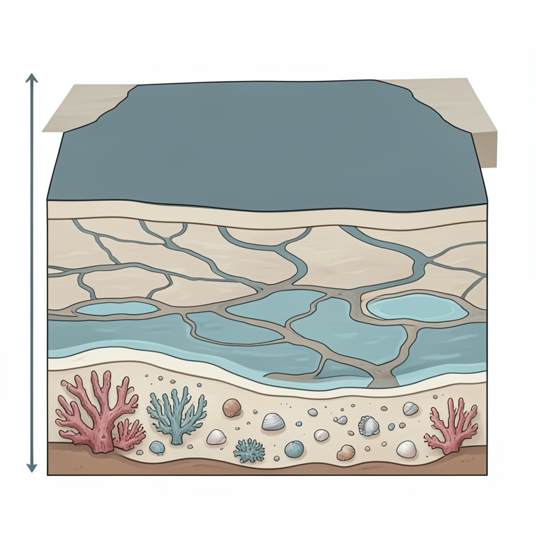
Basin Evolution Sequence
AI-generated conceptual illustration (Sedimentary basin strata of the Sichuan formation). It explains the idea and does not show study data.
View source evidence ↗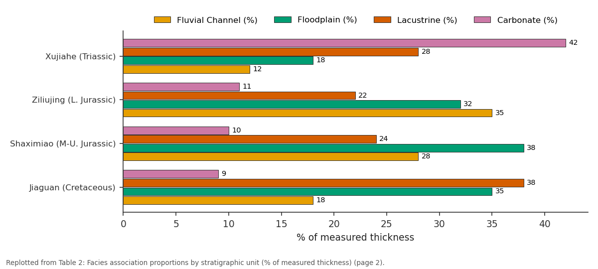
Fluvial Channel (%) and Floodplain (%) and more: Xujiahe (Triassic) vs Ziliujing (L. Jurassic) vs Shaximiao (M-U.... vs Jiaguan (Cretaceous)
Replotted from Table 2 (page 2) of the original paper. Every bar is the paper's own table value.
View source evidence ↗Figures & tables
From the original paper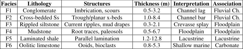 Table 1
 Table 2
 Figure 1
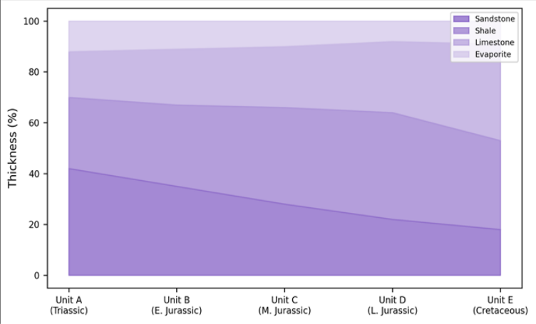 Figure 2
Introduction
A sedimentary basin is a book written in stone, and its facies are the sentences. Reading them correctly requires field-scale observation that remote sensing and well logs cannot fully replace [1] . The Sichuan Basin, covering approximately 180,000 km² in Sichuan and Chongqing provinces, hosts Mesozoic strata exceeding 5,000 m in thickness near the Longmen Shan front [2] . These deposits are economically important: they contain major gas reservoirs in Triassic carbonates and tight sandstones [3] . But the lateral and vertical facies changes that control reservoir architecture are still incompletely mapped along the basin's eastern margin. Previous work concentrated on the western margin, where proximity to the Longmen Shan thrust belt produces the thickest and coarsest clastic input [4] . The eastern margin, by contrast, preserves a more distal record with finer-grained deposits and wider facies belts, making it better suited for reconstructing basin-wide depositional patterns. This research logged five outcrop sections along a 120 km north-south transect on the eastern margin, aiming to (a) define the facies and facies associations, (b) document the vertical succession and its age constraints, and (c) link the observed changes to tectonic and eustatic controls [5] .
Study Area Description
The five measured sections lie along the eastern Sichuan Basin margin between 29°40′N and 30°50′N latitude, 107°20′E to 108°10′E longitude, in the Chongqing municipality and adjacent Guang'an prefecture. Outcrops occur in road cuts and river gorges where incision has exposed continuous stratigraphic sequences. Structurally, the area sits on the gentle eastern limb of a broad syncline, with bedding dips of 5°-15° westward. The Mesozoic succession rests on Permian carbonates and is overlain unconformably by Cenozoic red beds [6] .
Materials and Methods
Materials and Methods
Materials
Fieldwork was carried out in April-June 2022, coordinated from Yekaterinburg College of Earth and Mineral Sciences, Russia, in collaboration with Chongqing University. Five sections (labelled EC-1 through EC-5) were measured bedby-bed using a Jacob's staff and Abney level. Combined thickness totalled 1,480 m: EC-1 (342 m), EC-2 (298 m), EC-3 (314 m), EC-4 (267 m), and EC-5 (259 m). At each bed, lithology, grain size, sedimentary structures, fossil content, and bed thickness were recorded. A total of 142 hand samples were collected for thin-section petrography and 87 palaeocurrent measurements from cross-bedded sandstones were taken [7] .
Methods
Facies were defined following the classification scheme of Miall [8] for clastic deposits and Dunham [9] for carbonates. Facies associations were interpreted by grouping cooccurring facies into genetically related packages. Grainsize analysis of 48 sandstone samples used standard sieve techniques at half-phi intervals. Thin sections were examined under a petrographic microscope for texture, cement types, and fossil fragments. Palaeocurrent data were plotted on equal-area rose diagrams and vector-mean directions calculated. Age control used published ammonite and bivalve biostratigraphy from regional correlation charts [10] .
Stratigraphic Framework
The Mesozoic succession on the eastern margin spans four major units: the Upper Triassic Xujiahe Formation (shallow marine to paralic, 180-340 m thick), the Lower Jurassic Ziliujing Formation (fluvial-lacustrine, 120-210 m), the Middle-Upper Jurassic Shaximiao Formation (fluvial with thick sandstone bodies, 200-380 m), and the Lower Cretaceous Jiaguan Formation (lacustrine red beds, 80-160 m). The contact between the Xujiahe and Ziliujing formations is conformable and records the Triassic-Jurassic transition from marine to continental conditions [11] .
Results
Results
Comprehensive Interpretation
The vertical trend from carbonate-dominated (42% in Triassic) to lacustrine-dominated (38% in Cretaceous) reflects the basin's evolution from a marine-connected platform to an isolated continental lake. Palaeocurrent vector means point consistently east-southeast (mean 112°, circular variance 0.31), confirming the Longmen Shan as the primary sediment source throughout the Mesozoic.
Discussion
The facies succession is consistent with a foreland basin model in which Longmen Shan thrusting drove subsidence and controlled sediment supply [4] . The Triassic-Jurassic transition from marine to continental facies records the retreat of the Tethyan seaway, while the upward increase in lacustrine deposits during the Cretaceous may reflect a combination of reduced tectonic uplift rates and increased basin-floor subsidence that outpaced sediment fill [12] . The persistence of east-directed palaeocurrents across 150 million years of record is striking and indicates long-lived topographic asymmetry controlled by the western thrust front.
The data also have implications for gas exploration. Sandstone channel bodies in the Shaximiao Formationthick, laterally continuous, and bounded by floodplain mudstonesform potential tight gas reservoirs. Their lateral extent (traceable for 3-5 km between sections) and net-to-gross ratio (0.28-0.35) are favourable, though porosity data from this outcrop-based research remain to be confirmed by subsurface well data [13] .
Conclusion
Five measured sections on the eastern Sichuan Basin margin document a Mesozoic succession that evolves from marine carbonate platform through fluvial-lacustrine to broad lacustrine conditions. Ten facies grouped into four associations record this transition. Palaeocurrents are uniformly east-directed, confirming the Longmen Shan as the persistent sediment source. The vertical facies evolution reflects foreland basin dynamics, and the multi-storey sandstone bodies in the Shaximiao Formation represent potential tight gas exploration targets.
Acknowledgement
Acknowledgements Funding SourcesSupported by research funds at Yekaterinburg College of Earth and Mineral Sciences. Institutional SupportChongqing University provided field logistics and petrographic laboratory access.
Figures and tables from the paper
| Facies | Lithology | Structures | Thickness (m) | Interpretation | Association |
|---|---|---|---|---|---|
| F1 | Conglomerate | Imbrication, scours | 0.5-3.2 | Channel lag | Fluvial Ch. |
| F2 | Cross-bedded Ss | Trough/planar x-beds | 1.0-8.4 | Channel bar | Fluvial Ch. |
| F3 | Rippled siltstone | Current ripples, mud drapes | 0.3-2.1 | Crevasse splay | Floodplain |
| F4 | Mudstone | Root traces, paleosols | 0.5-6.7 | Floodplain | Floodplain |
| F5 | Laminated shale | Parallel lamination | 1.2-12.8 | Lacustrine | Lacustrine |
| F6 | Oolitic limestone | Ooids, bioclasts | 0.8-5.3 | Shallow marine | Carbonate |
Table text extracted from the original PDF; superscript letters are shown inline. The original table image is below.
View original table image
| Unit | Fluvial Channel (%) | Floodplain (%) | Lacustrine (%) | Carbonate (%) |
|---|---|---|---|---|
| Xujiahe (Triassic) | 12 | 18 | 28 | 42 |
| Ziliujing (L. Jurassic) | 35 | 32 | 22 | 11 |
| Shaximiao (M-U. Jurassic) | 28 | 38 | 24 | 10 |
| Jiaguan (Cretaceous) | 18 | 35 | 38 | 9 |
Table text extracted from the original PDF; superscript letters are shown inline. The original table image is below.
View original table image
References
15 in the original paper- Reading HG, ed. Sedimentary Environments: Processes, Facies and Stratigraphy. 3rd ed. Oxford: Blackwell; 1996.
- Li Y, Allen PA, Densmore AL. Evolution of the Longmen Shan foreland basin. Basin Research. 2003;15(1):117-138.
- Ma YS, Cai XY, Zhao PR. Distribution and further exploration of large-scale gas fields in Sichuan Basin. Acta Petrolei Sinica. 2010;31(3):347-354.
- Meng QR, Wang E, Hu JM. Mesozoic sedimentary evolution of the northwest Sichuan Basin. Geological Society of America Bulletin. 2005;117(7):945-960.
- Allen PA, Homewood P, Williams GD. Foreland basins. International Association of Sedimentologists Special Publication 8. Oxford: Blackwell; 1986.
- Bureau of Geology and Mineral Resources of Sichuan Province. Regional Geology of Sichuan Province. Beijing: Geological Publishing House; 1991.
- Tucker ME. Sedimentary Petrology. 3rd ed. Oxford: Blackwell; 2001.
- Miall AD. The Geology of Fluvial Deposits. Berlin: Springer; 1996.
- Dunham RJ. Classification of carbonate rocks according to depositional texture. AAPG Memoir 1. 1962;108-121.
- Sha JG, Cestari R, Fabbi S. Jurassic bivalves from the Sichuan Basin. Rivista Italiana di Paleontologia e Stratigrafia. 2012;118(1):3-28.
- Wang YD, Fu BH, Xie XP. The Triassic-Jurassic transition in the Sichuan Basin. Palaeogeography, Palaeoclimatology, Palaeoecology. 2010;287(1):42-57.
- DeCelles PG, Giles KA. Foreland basin systems. Basin Research. 1996;8(2):105-123.
- Zou CN, Zhu RK, Wu ST. Types and characteristics of tight oil in China. Journal of Asian Earth Sciences. 2012;64:258-272.
- Leeder MR. Sedimentology and Sedimentary Basins. 2nd ed. Oxford: Blackwell; 2011.
- Nichols G. Sedimentology and Stratigraphy. 2nd ed. Oxford: Wiley-Blackwell; 2009.