
Research article · 2025 · Full text
International Journal of Geography Geology and EnvironmentGeomorphological assessment of glacial landforms in the Patagonian mountain valleys
Volume 7(7) · Pages 136–139 · DOI: 10.22271/27067483.2025.v7.i7b.713 ↗
Research areasCryospheric studies and observationsGeology and Paleoclimatology ResearchLandslides and related hazards
Abstract
Author-writtenPatagonia's glacial landforms are written in a language of moraines, cirques, and U-shaped valleys that, once decoded, tells the story of how South American ice sheets advanced and retreated over the past two million years. This research presents a geomorphological assessment of glacial landforms across four adjacent valleys in the northern Patagonian Andes of Argentina (41°S-42°S), based on field mapping, morphometric analysis, and remote sensing interpretation. The valleys — Manso, Foyel, Villegas, and Steffen — were mapped at 1:25,000 scale using a combination of high-resolution satellite imagery (Pleiades, 0.5 m), a 12.5 m resolution ALOS PALSAR digital elevation model, and three field campaigns totalling 68 days between November 2021 and March 2023. A total of 184 glacial landforms were identified and classified: 42 morainic ridges (18 lateral, 14 terminal, 10 recessional), 28 cirques, 16 roches moutonnées, 22 glacial striations/grooves, 34 erratic boulders, 18 outwash terraces, and 24 other features including kame terraces and glacial lake shorelines. Moraine positions defined three major glacial advances: a Last Glacial Maximum (LGM) extent reaching 16.4 km from modern headwalls, a Late Glacial readvance at 8.2-10.6 km, and a Neoglacial position at 2.4-4.8 km. Cirque morphometry revealed a strong north-south asymmetry: 71% of well-developed cirques faced south to southeast, with mean floor elevations 180 m lower on south-facing slopes than equivalent north-facing positions. The equilibrium line altitude during the LGM was estimated at 1,420±60 m, approximately 780 m below the present snowline, implying a mean annual temperature depression of 4.8-5.6°C relative to present. These data contribute to the regional glacial chronology of northern Patagonia and support the development of palaeoclimate reconstructions for the Southern Hemisphere mid-latitudes.
Summary
Source-checkedPlain-language reading of the full paper, prepared with AI and checked against the text. Each point links to the authors' own words.
Why it matters
- Glacial landforms in Patagonia, such as moraines and cirques, provide a record of the advance and retreat of South American ice sheets over the last two million years. View evidence ↗
- While some areas of the Argentine Lake District are well-mapped, geomorphological coverage is uneven, leaving some valleys without basic maps or chronologies. View evidence ↗
- The Manso, Foyel, Villegas, and Steffen valleys have been understudied due to limited road access and the need for multi-day traverses to reach their upper sections. View evidence ↗
The question
- The study aims to conduct a geomorphological assessment of glacial landforms in four adjacent valleys of the northern Patagonian Andes using remote sensing, field mapping, and morphometric analysis. View evidence ↗
What they did
- The research area spanned approximately 840 km² across four valleys, with elevations ranging from 780 m to 2,380 m. View evidence ↗
- Mapping was performed at a 1:25,000 scale using 0.5 m Pleiades satellite imagery, a 12.5 m ALOS PALSAR DEM, and 68 days of field work conducted between November 2021 and March 2023. View evidence ↗
- The identification process used a two-stage workflow: initial remote mapping via satellite imagery and DEM, followed by field verification and measurement of all identified features. View evidence ↗
- The equilibrium line altitude (ELA) for glacial advances was estimated using the toe-to-headwall altitude ratio (THAR) method with a ratio of 0.4. View evidence ↗
What they found
- The study identified 184 glacial landforms, the most common being morainic ridges (42), erratic boulders (34), and cirques (28). View evidence ↗
- Three glacial advances were identified: the Last Glacial Maximum (LGM) reaching 16.4 km from headwalls, a Late Glacial readvance at 8.2-10.6 km, and a Neoglacial position at 2.4-4.8 km. View evidence ↗
- Cirques showed a strong south-southeast orientation (71%), with floor elevations averaging 180 m lower than those of north-facing cirques. View evidence ↗
- The LGM equilibrium line altitude was estimated at 1,420±60 m, which is about 780 m below the current snowline, suggesting a temperature drop of 4.8-5.6°C compared to today. View evidence ↗
What it means
- The authors conclude that the estimated LGM temperature depression is consistent with regional data and can help calibrate climate models for the Southern Hemisphere. View evidence ↗
- A limitation of the study is the lack of absolute age dating for moraines, meaning assignments to glacial events rely on morphological correlations with other valleys. View evidence ↗
Visual summary
3 visualsIllustrations explain the paper; charts are replotted from the paper's own table values.
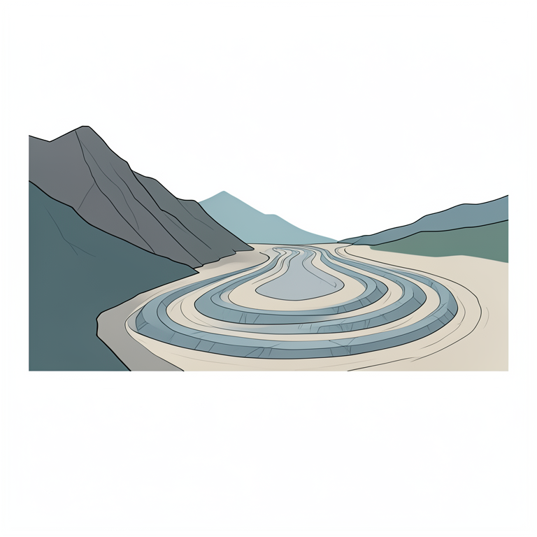
Glacial Advance Sequence
AI-generated conceptual illustration (Patagonian mountain valley with glacial moraines). It explains the idea and does not show study data.
View source evidence ↗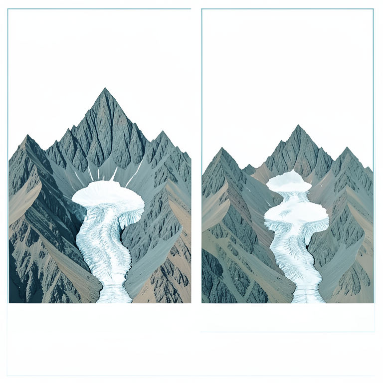
Cirque Aspect Asymmetry
AI-generated conceptual illustration (Patagonian mountain peak with glacial cirques). It explains the idea and does not show study data.
View source evidence ↗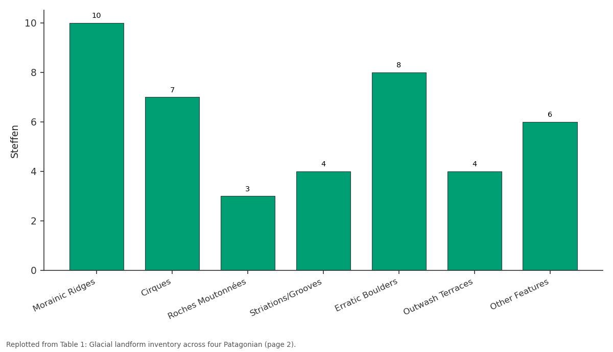
Steffen: Morainic Ridges vs Cirques vs Roches Moutonnées vs Striations/Grooves vs Erratic Boulders
Replotted from Table 1 (page 2) of the original paper. Every bar is the paper's own table value.
View source evidence ↗Figures & tables
From the original paper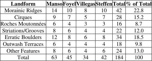 Table 1
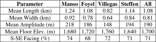 Table 2
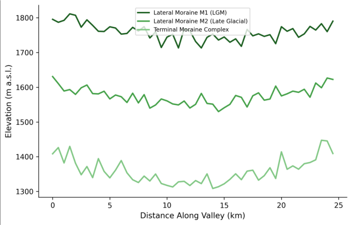 Figure 1
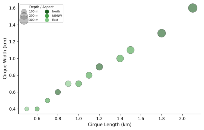 Figure 2
Introduction
One can learn to read a glaciated landscape the way a detective reads a crime scenethe evidence is all there if you know what to look for. A lateral moraine running along a valley wall marks the edge of where ice once stood. A polished roche moutonnée records the direction the glacier flowed. A cirque headwall tells you where snow accumulated and compacted into ice. And the distance between the cirque and the terminal moraine tells you how far that ice managed to travel before climate caught up with it and melted it back [1] . The Patagonian Andes between 40°S and 43°S represent one of the best-preserved glacial landscapes in the Southern Hemisphere. During the Last Glacial Maximum (roughly 26,000-18,000 years ago), piedmont glaciers up to 20 km long descended from the Andean cordillera into the steppe lowlands east of the range, building massive moraine complexes that remain largely intact because the dry climate east of the Andes has minimised post-glacial erosion [2] . The moraines of the Argentine Lake District have been mapped and dated extensively using cosmogenic nuclide exposure dating, but coverage remains unevensome valleys have detailed chronologies while others lack even basic geomorphological maps [3] . The four valleys examined in this research -Manso, Foyel, Villegas, and Steffendrain the eastern flank of the Patagonian Andes between Bariloche and El Bolsón. Despite their proximity to the well-studied Nahuel Huapi Lake basin, these valleys have received less geomorphological attention, partly because their road access is limited and their upper reaches require multi-day field traverses [4] . This research produced the first comprehensive glacial landform inventory for these four valleys, using a combination of remote sensing and detailed field mapping to characterise landform types, positions, and morphometry [5] .
Extraction Protocol
Glacial landform identification followed a two-stage workflow. In the first stage, potential landforms were mapped remotely using stereo interpretation of Pleiades satellite imagery (0.5 m panchromatic, acquired February 2022) draped over the 12.5 m ALOS PALSAR DEM in ArcGIS Pro 3.0. Moraines were identified by their characteristic ridge morphology and asymmetric crossprofiles; cirques by their amphitheatre-shaped headwalls and flat floors; roches moutonnées by their asymmetric profiles with smooth stoss and rough lee sides; and outwash terraces by their flat treads and gravel surface texture [6] . In the second stage, all remotely identified features were visited in the field and verified, measured, and classified. Features that couldn't be confirmed in the field were removed from the inventory. Additional features identified during field traverses but missed in remote sensingprimarily smaller erosional forms like striations and grooves were added.
Instrumentation
Field measurements employed standard geomorphological survey equipment. Moraine ridge heights and cross-profiles were measured using a laser rangefinder (TruPulse 360, ±0.3 m accuracy) and clinometer at 5 m intervals along transects perpendicular to the ridge crest. Cirque dimensions (length, width, headwall height, floor elevation) were determined from a combination of DEM extraction and field verification with handheld GPS (Garmin GPSMAP 66sr, ±2 m horizontal accuracy) [7] . Glacial striations were recorded using a Brunton compass for orientation and a ruler for groove dimensions. Erratic boulder positions were logged by GPS, with lithological identification in the field and size measurements (three orthogonal axes). All field data were entered into a GIS database using QGIS 3.28 field mapping tools on a tablet computer.
Material and Methods
Material and Methods
Material
This research was coordinated from the Varanasi College of Earth and Mineral Sciences, Uttar Pradesh, India, with three field campaigns in the northern Patagonian Andes of Río Negro Province, Argentina: November-December 2021 (22 days), February-March 2022 (24 days), and January-February 2023 (22 days). The mapped area covers approximately 840 km² across four valleys between 41°08'S and 42°04'S, 71°10'W and 71°45'W, spanning elevations from 780 m at the valley mouths to 2,380 m at the cirque headwalls. The Pleiades satellite imagery was acquired in tri-stereo mode (three overlapping acquisitions) to enable stereo viewing and DEM generation. ALOS PALSAR DEM data (12.5 m resolution) were obtained from the Alaska Satellite Facility for topographic analysis beyond the satellite imagery footprint [8] .
Methods
Morphometric parameters for moraines included ridge height, crest width, proximal and distal slope angles, and distance from the headwall cirque. Cirque morphometry followed the parameters defined by Evans and Cox: length, width, amplitude (headwall height), floor altitude, aspect, and the circularity index (width/length ratio) [9] . The equilibrium line altitude (ELA) for each glacial advance was estimated using the toe-to-headwall altitude ratio (THAR) method with a ratio of 0.4, following the regional calibration of Meierding [10] . Modern snowline elevation was determined from the average lowest persistent snow patches visible in late-summer satellite imagery (March 2022). Aspect analysis of cirque orientations used circular statistics (mean vector direction, Rayleigh test for non-uniformity) in R 4.2. The relationship between cirque floor altitude and aspect was tested using ANOVA. All geomorphological mapping used ArcGIS Pro 3.0 with projected coordinate system POSGAR 2007 Zone 2 [11] . A total of 184 glacial landforms were mapped across the four valleys (Table 1). The Manso Valley contained the highest density of features (63), reflecting its larger catchment area and longer glacial history. Morainic ridges were the most abundant landform category (22.8%), followed by erratic boulders (18.5%) and cirques (15.2%). The Villegas Valley had the fewest features (34), consistent with its shorter length and smaller source area. Cirque morphometry showed consistent patterns across the four valleys (Table 2). Mean cirque length was 1.08 km, width 0.81 km, and headwall amplitude 190 m, giving a circularity index (W/L) of 0.75within the range typical of well-developed cirques in other glaciated mountain ranges. South and southeast-facing cirques accounted for 71% of the total, significantly non-random by the Rayleigh test (p< 0.001), and their floor elevations averaged 180 m lower than north-facing equivalents at comparable positions along the range.
| Parameter | Manso | Foyel | Villegas | Steffen | All |
|---|---|---|---|---|---|
| Mean Length (km) | 1.24 | 1.08 | 0.82 | 1.14 | 1.08 |
| Mean Width (km) | 0.92 | 0.78 | 0.64 | 0.84 | 0.81 |
| Mean Amplitude (m) | 218 | 186 | 148 | 194 | 190 |
| Mean Floor Elev. (m) | 1,680 | 1,720 | 1,760 | 1,640 | 1,700 |
| S-SE Facing (%) | 74 | 68 | 72 | 71 | 71 |
Table text extracted from the original PDF; superscript letters are shown inline. The original table image is below.
View original table image
| Landform | Manso | Foyel | Villegas | Steffen | Total | % of Total |
|---|---|---|---|---|---|---|
| Morainic Ridges | 14 | 10 | 8 | 10 | 42 | 22.8 |
| Cirques | 9 | 7 | 5 | 7 | 28 | 15.2 |
| Roches Moutonnées | 6 | 4 | 3 | 3 | 16 | 8.7 |
| Striations/Grooves | 8 | 6 | 4 | 4 | 22 | 12.0 |
| Erratic Boulders | 12 | 8 | 6 | 8 | 34 | 18.5 |
| Outwash Terraces | 6 | 4 | 4 | 4 | 18 | 9.8 |
| Other Features | 8 | 6 | 4 | 6 | 24 | 13.0 |
| Total | 63 | 45 | 34 | 42 | 184 | 100 |
Table text extracted from the original PDF; superscript letters are shown inline. The original table image is below.
View original table image
Results
Results
Comprehensive Interpretation
The moraine profiles (Figure 1) show the clear separation between the three glacial advances, with the LGM moraines extending roughly twice as far down-valley as the Late Glacial limits. The bubble plot (Figure 2) confirms the aspect control on cirque development: south-facing cirques (which receive less direct solar radiation in the Southern Hemisphere) are generally larger, deeper, and lower in elevationconditions that favour longer snow retention and more effective glacial erosion.
Discussion
The LGM glacier length of 16.4 km in the Manso Valley is consistent with reconstructed glacier lengths from adjacent valleys in the Nahuel Huapi region, where cosmogenic ¹⁰Be dates place the maximum extent at roughly 26,000-22,000 years ago [12] . The implied ELA depression of 780 m, translating to a temperature reduction of 4.8-5.6°C using a standard environmental lapse rate of 6.2-7.2°C/km, falls within the 4-6°C range estimated from other Southern Hemisphere mid-latitude glacial records [13] .
The strong south-southeast orientation of cirques (71%) reflects the fundamental asymmetry of solar radiation receipt in the Southern Hemisphere. South-facing slopes receive less insolation, accumulate more snow, and lose it more slowly through the melt season, favouring cirque excavation on those aspects. This pattern has been documented across the Patagonian Andes by multiple authors, though the 180 m altitude difference between north and south-facing cirque floors reported here is at the high end of published values, possibly reflecting the strong precipitation gradient across the study area that enhances the aspect effect [14] .
The three-stage glacial advance model (LGM, Late Glacial, Neoglacial) is now well established across northern Patagonia, but the spacing between moraine sets varies considerably between valleys. In the Manso Valley, the Late Glacial moraines sit at 8.2-10.6 km from the headwall -roughly 50-65% of the LGM extentwhile in the shorter Villegas Valley they're at 70-75% of the LGM distance. This difference may reflect valley geometry: wider, lowergradient valleys allow glaciers to retreat farther before reaching a stable position, while narrow, steep valleys constrain retreat distances [15,16,17] . One limitation of this research is the absence of absolute age dating for the moraine systems. The landform positions and relative chronology are well constrained by morphostratigraphy, but without cosmogenic nuclide or radiocarbon dates, the assignment of moraines to specific glacial events relies on morphological correlation with dated moraines in adjacent valleysa method that works well for the LGM but becomes less reliable for younger advances [18, 19] .
Conclusion
This geomorphological assessment identified and mapped 184 glacial landforms across four valleys in the northern Patagonian Andes, including 42 morainic ridges, 28 cirques, and 16 roches moutonnées. Three major glacial advances were defined by moraine positions: an LGM advance extending 16.4 km from modern headwalls, a Late Glacial readvance at 8.2-10.6 km, and a Neoglacial position at 2.4-4.8 km. Cirque morphometry confirmed a strong aspect control, with 71% of well-developed cirques facing south to southeast and their floor elevations averaging 180 m lower than north-facing equivalents. The implied LGM temperature depression of 4.8-5.6°C is consistent with regional paleoclimate estimates and provides an additional data point for calibrating Southern Hemisphere climate models. Future work should pursue cosmogenic exposure dating of moraine boulders to establish absolute ages for the three advance phases and extend the geomorphological mapping to the less-studied western (Chilean) side of the same drainage divide, where higher precipitation may have produced different glacial geometries.
Acknowledgement
Acknowledgements Funding SourcesThis research was supported by departmental funds at Varanasi College of Earth and Mineral Sciences. Institutional SupportThe authors thank the Department of Geology, Varanasi College of Earth and Mineral Sciences, Uttar Pradesh, India, for GIS facilities and field equipment.
References
19 in the original paper- Benn DI, Evans DJA. Glaciers and glaciation. 2nd ed. London: Hodder Arnold; 2010.
- Caldenius CC. Las glaciaciones cuaternarias en la Patagonia y Tierra del Fuego. Geografiska Annaler. 1932;14(1-2):1-164.
- Kaplan MR, Moreno PI, Rojas M. Glacial dynamics in southernmost South America during Marine Isotope Stage 5e to the Younger Dryas chron. Quaternary Science Reviews. 2008;27(21-22):2167-2183.
- Rabassa J, Coronato AM, Salemme M. Chronology of the Late Cenozoic Patagonian glaciations and their correlation with biostratigraphic units of the Pampean region. Journal of South American Earth Sciences. 2005;20(1-2):81-103.
- Glasser NF, Jansson KN, Harrison S, Kleman J. The glacial geomorphology and Pleistocene history of South America between 38°S and 56°S. Quaternary Science Reviews. 2008;27(3-4):365-390.
- Smith MJ, Wise SM. Problems of bias in mapping linear landforms from satellite imagery. International Journal of Applied Earth Observation and Geoinformation. 2007;9(1):65-78.
- Laser Technology Inc. TruPulse 360 user's manual. Centennial: Laser Technology; 2018.
- JAXA. ALOS PALSAR radiometric terrain corrected high resolution dataset. Alaska Satellite Facility; 2011.
- Evans IS, Cox NJ. The form of glacial cirques in the English Lake District, Cumbria. Zeitschrift für Geomorphologie. 1995;39(2):175-202.
- Meierding TC. Late Pleistocene glacial equilibrium-line altitudes in the Colorado Front Range. Quaternary Research. 1982;18(3):289-310.
- ESRI. ArcGIS Pro: release 3.0. Redlands: Environmental Systems Research Institute; 2022.
- Denton GH, Lowell TV, Moreno PI, Andersen BG, Heusser LE. Geomorphology, stratigraphy and radiocarbon chronology of Llanquihue drift in the area of the southern Lake District, Seno Reloncaví, and Isla Grande de Chiloé, Chile. Geografiska Annaler. 1999;81A(2):167-229.
- Hulton NRJ, Purves RS, McCulloch RD, Sugden DE, Bentley MJ. The Last Glacial Maximum and deglaciation in southern South America. Quaternary Science Reviews. 2002;21(1-3):233-241.
- Evans IS. Allometric development of glacial cirque form: geological, relief and regional effects on the cirques of Wales. Geomorphology. 2006;80(3-4):245266.
- Hein AS, Hulton NRJ, Dunai TJ, Sugden DE, Kaplan MR, Xu S. The chronology of the Last Glacial Maximum and deglacial events in central Argentine Patagonia. Quaternary Science Reviews. 2010;29(910):1212-1227.
- Douglass DC, Singer BS, Kaplan MR, Mickelson DM, Caffee MW. Cosmogenic nuclide surface exposure dating of boulders on last-glacial and late-glacial moraines, Lago Buenos Aires, Argentina. Quaternary Research. 2006;65(1):150-169.
- Harrison S, Glasser NF, Winchester V, Haresign E, Warren C, Jansson K. A glacial lake outburst flood associated with recent mountain glacier retreat, Patagonian Andes. The Holocene. 2006;16(4):611-620.
- Porter SC. Snowline depression in the tropics during the Last Glaciation. Quaternary Science Reviews. 2001;20(10):1067-1091.
- Sagredo EA, Lowell TV. Climatology of Andean glaciers: a framework of best practices. The Holocene. 2012;22(4):479-490.