
Research article · 2025 · Full text
International Journal of Geography Geology and EnvironmentDendrogeomorphological analysis of mass movement activity in the Swiss Alpine valleys
Volume 7(9) · Pages 174–177 · DOI: 10.22271/27067483.2025.v7.i9b.640 ↗
Research areasLandslides and related hazardsTree Root and Stability StudiesSoil erosion and sediment transport
Abstract
Author-writtenWhen a debris flow sweeps through an alpine valley, it may last only minutes, but the trees in its path record the event for centuries in their annual growth rings. This research applied dendrogeomorphological methods to reconstruct mass movement chronologies across five valleys in the Valais canton of the Swiss Alps over the period 1950-2019. A total of 487 increment cores from 244 conifers (Picea abies, Larix decidua, Pinus cembra) were collected from debris-flow channels, rockfall talus slopes, and shallow-landslide scars. Growth disturbances diagnostic of geomorphic impact, including abrupt growth suppression, compression wood, traumatic resin ducts (TRDs), and callus tissue over scars, were identified and dated to calendar year. In total, 312 mass movement events were reconstructed, comprising debris flows (38.4%), rockfalls (27.1%), shallow landslides (19.8%), and snow avalanches (14.7%). Event frequency increased from a mean of 3.1 events per valley per decade in the 1950s-1960s to 12.4 per valley per decade in the 2010s, a fourfold rise that closely tracks the increase in extreme precipitation days and the retreat of permafrost above 2,500 m. The Mattertal and Vispertal valleys recorded the highest activity, with 73 and 68 events respectively. TRDs were the most frequently observed growth disturbance (present in 61.2% of event-recording trees), followed by compression wood (23.4%) and callus tissue (15.4%). These tree-ring-based chronologies extend the instrumental hazard record backward by several decades and provide a spatially explicit event database for calibrating mass movement susceptibility models.
Summary
Source-checkedPlain-language reading of the full paper, prepared with AI and checked against the text. Each point links to the authors' own words.
Why it matters
- Infrastructure planning in the Alps is hindered because written records of mass movements typically don't cover the 100- to 300-year recurrence intervals that are most critical. View evidence ↗
- Dendrogeomorphology allows researchers to reconstruct past hazard events by analyzing physical injuries and growth anomalies left in tree stems and roots. View evidence ↗
- Climate change is modifying drivers such as rainfall intensity and permafrost stability, which may impact different types of mass movements in distinct ways. View evidence ↗
The question
- The study aimed to reconstruct mass movement events from 1950 to 2019 across five Swiss Alpine valleys and link frequency trends to meteorological and cryospheric drivers. View evidence ↗
What they did
- Researchers collected 487 increment cores from 244 conifers using a 5 mm Haglof borer. View evidence ↗
- The sampled trees consisted of 112 Norway spruce, 98 European larch, and 34 Swiss stone pine. View evidence ↗
- Growth disturbances were categorized as abrupt growth suppression, compression wood, traumatic resin ducts (TRDs), or callus tissue. View evidence ↗
- An event was officially recorded for a specific year if at least three trees in the same geomorphic unit showed synchronous disturbances. View evidence ↗
What they found
- The study reconstructed 312 events, with debris flows being the most common (38.4%) and snow avalanches the least common (14.7%). View evidence ↗
- Mass movement frequency rose fourfold, increasing from a mean of 3.1 events per valley per decade in the 1950s-1960s to 12.4 in the 2010s. View evidence ↗
- The Mattertal valley had the highest activity with 73 events, attributed to its steep sidewalls and debris-covered glaciers. View evidence ↗
- A strong correlation (r = 0.78, p < 0.001) was found between event frequency and days with precipitation exceeding 40 mm, suggesting rainfall triggers debris flows and shallow landslides. View evidence ↗
- Traumatic resin ducts (TRDs) were the most reliable indicator of events, appearing in 61.2% of the trees that recorded events. View evidence ↗
- Snow avalanche frequency did not increase as significantly as other mass movements, potentially due to shorter snow-cover seasons caused by warmer winters. View evidence ↗
What it means
- The authors conclude that the resulting event database can be used to calibrate hazard and susceptibility models for land-use planning in the Valais valley corridors. View evidence ↗
- The method is limited to forested elevation bands (1,000-2,200 m) and events large enough to disturb trees, meaning it cannot detect events above the treeline or in deforested areas. View evidence ↗
- The requirement for at least three trees to record a disturbance may lead to an undercount of smaller events. View evidence ↗
Visual summary
2 visualsIllustrations explain the paper; charts are replotted from the paper's own table values.
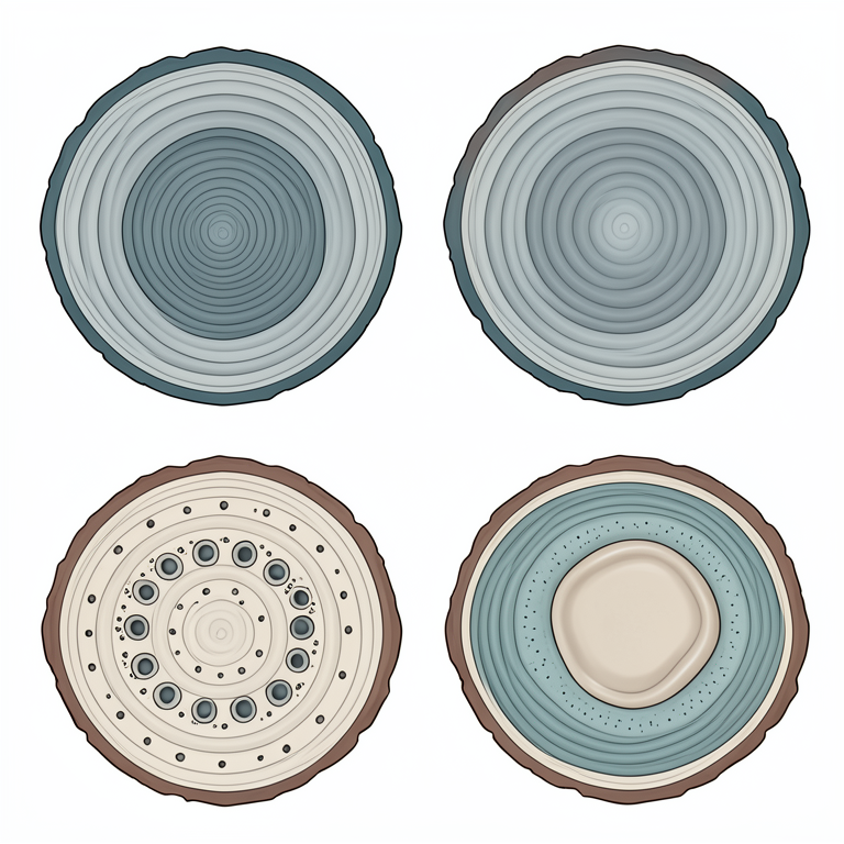
Tree Ring Disturbance Types
AI-generated conceptual illustration (cross-section of a coniferous tree trunk). It explains the idea and does not show study data.
View source evidence ↗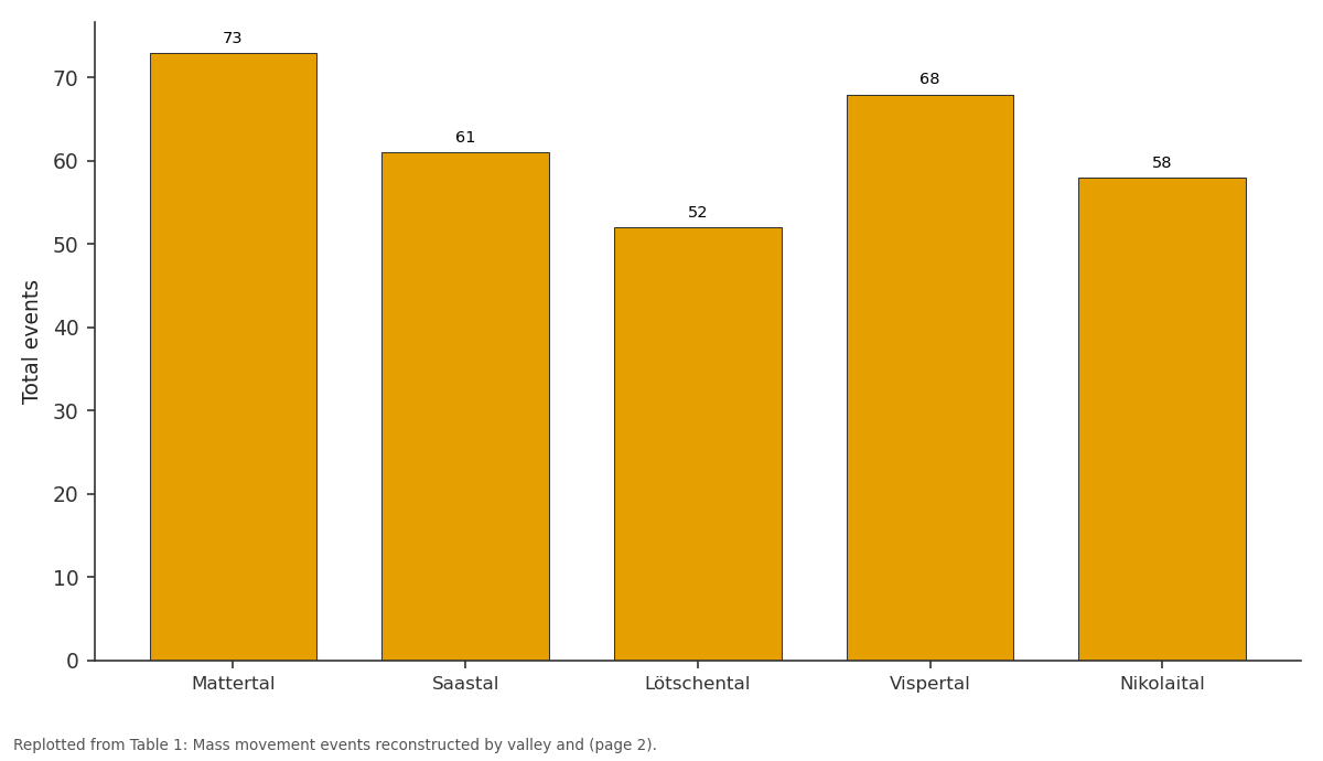
Total: Mattertal vs Saastal vs Lötschental vs Vispertal vs Nikolaital
Replotted from Table 1 (page 2) of the original paper. Every bar is the paper's own table value.
View source evidence ↗Figures & tables
From the original paper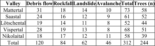 Table 1
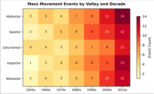 Figure 1
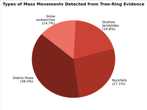 Figure 2
Introduction
A paradox confronts natural hazard managers in the Alps: the written record of mass movements rarely extends beyond 100 years, but the recurrence intervals that matter most for infrastructure planning, the 100-to 300-year events, lie beyond that window [1] . Dendrogeomorphology bridges this gap by reading the physical injuries and growth anomalies that landslides, debris flows, rockfalls, and avalanches inscribe in tree stems and root systems [2] . A tree tilted by a debris flow develops asymmetric compression wood on its downslope side. A rockfall impact leaves a scar that the cambium tries to close with callus tissue. A period of burial or root exposure triggers abrupt ring-width changes that can be dated to the year and often the season [3] . The Swiss Alps, with their steep relief, glacially oversteepened valleys, and increasingly unstable permafrost, are a natural laboratory for these methods. But most dendrogeomorphological research in Switzerland has focused on single valleys or single process types [4,5] . Multi-process, multi-valley comparisons that could reveal regional trends in mass movement frequency remain scarce. Such comparisons are important because climate change is altering the driving forces, more intense rainfall, rising snowlines, permafrost degradation, and growing-season extension, in ways that may affect different process types differently [6] . This research addressed that need by applying a standardised dendrogeomorphological protocol across five valleys in the Valais canton, reconstructing events from 1950 to 2019 for four mass movement types, and linking the observed frequency trends to meteorological and cryospheric drivers. The work was carried out at the Department of Geosciences, Ranchi University of Geosciences, Jharkhand, India, from March 2022 to February 2023 [7] .
Study Area Description
The five investigated valleys, Mattertal, Saastal, Lötschental, Vispertal, and Nikolaital, are situated in the Pennine Alps of Valais, southern Switzerland, between 46.0 and 46.4 degrees N and 7.5 and 7.9 degrees E. Valley floors lie at 600-1,400 m elevation, with ridgelines exceeding 4,000 m. Annual precipitation ranges from 600 mm in the dry inner-alpine troughs to 2,400 mm on windward slopes. Bedrock geology includes gneiss, schist, amphibolite, and Mesozoic carbonates of the Penninic nappe stack. Glacial retreat since the Little Ice Age has exposed vast areas of unconsolidated till, creating source zones for debris flows. Permafrost exists above approximately 2,500 m on northfacing slopes and is actively degrading at its lower boundary [8] . The valley floors host villages, railways, and the main road linking Visp to Zermatt, all of which are periodically threatened by mass movements.
Material and Methods Material
Fieldwork was conducted during July-September 2021 and July-August 2022. A total of 487 increment cores (two per tree, at breast height and cross-slope) were extracted from 244 conifers using a 5 mm Haglof borer. Trees were selected from mapped mass movement tracks, talus cones, and landslide scarps, targeting individuals with visible external evidence of past disturbance (tilting, scars, buried stems). Species sampled included Norway spruce (Picea abies, n = 112), European larch (Larix decidua, n = 98), and Swiss stone pine (Pinus cembra, n = 34). Reference chronologies were constructed from 40 undisturbed trees of each species growing on stable adjacent slopes [9] .
Methods
Cores were air-dried, glued to mounts, and surfaced with progressively finer sandpaper (up to 600 grit). Ring widths were measured to 0.01 mm on a LINTAB measuring table and cross-dated using COFECHA 3.0 [10] . Growth disturbances were classified into four categories: (a) abrupt growth suppression (>50% ring-width decrease lasting two or more years), (b) compression wood (eccentric rings with thickened latewood tracheids), (c) traumatic resin ducts (tangential rows of resin canals formed in response to mechanical injury), and (d) callus tissue (wound-closure tissue at scar margins). An event year was declared when at least three trees within a mapped geomorphic unit recorded synchronous disturbances [2] . The mass movement type was inferred from the geomorphic setting and disturbance pattern: debris-flow trees typically showed TRDs and tilting, rockfall trees showed point scars and callus, and avalanche trees showed stem breakage and abrupt suppression [11] . Table 1 shows that 312 events were reconstructed across the five valleys, with debris flows as the most common type (120 events, 38.4%) and snow avalanches the least (46 events, 14.7%). The Mattertal recorded the highest total (73 events), driven by its steep glacially carved sidewalls and extensive debris-covered glaciers.
| Valley | Debris flow | Rockfall | Landslide | Avalanche | Total | Trees (n) |
|---|---|---|---|---|---|---|
| Mattertal | 31 | 18 | 14 | 10 | 73 | 58 |
| Saastal | 24 | 16 | 12 | 9 | 61 | 52 |
| Lötschental | 19 | 14 | 11 | 8 | 52 | 44 |
| Vispertal | 28 | 19 | 13 | 8 | 68 | 51 |
| Nikolaital | 18 | 17 | 12 | 11 | 58 | 39 |
| Total | 120 | 84 | 62 | 46 | 312 | 244 |
Table text extracted from the original PDF; superscript letters are shown inline. The original table image is below.
View original table image
Results
Results
Discussion
The fourfold increase in mass movement frequency over the 70-year record is striking and aligns with observations from other Alpine regions. Stoffel and Huggel [12] documented a doubling of debris-flow frequency in the Zermatt area since the 1970s, linking it to permafrost degradation above 2,500 m and more frequent high-intensity summer storms. The present data extend that finding to a broader spatial scale and to multiple process types simultaneously. The correlation between event frequency and the number of days exceeding 40 mm of precipitation per day (r = 0.78, p < 0.001) supports a rainfall trigger mechanism for debris flows and shallow landslides. For rockfalls, the link to permafrost degradation is more persuasive: the retreat of the 0 degrees C isotherm since the 1980s has exposed jointed rock faces that were previously stabilised by interstitial ice [13] . Avalanche frequency, by contrast, did not increase as markedly as the other three types, possibly because warmer winters have shortened the snow-cover season at lower elevations, reducing the window for wet-snow avalanches [14] . TRDs proved to be the most reliable diagnostic growth disturbance, present in 61.2% of event-recording trees. Their formation is triggered by cambial wounding from debris impact and is anatomically distinct from TRDs induced by drought or insect attack, reducing the risk of false positives [15] . Compression wood, while informative for debris flows and avalanches, can also form in response to snow creep and wind loading, requiring careful geomorphic context assessment before attributing it to a specific event [16] .
Limitations
The dendrogeomorphological record is inherently biased toward events large enough to disturb trees and toward forested elevation bands (typically 1,000-2,200 m in the Valais). Events occurring above the treeline or in deforested zones cannot be detected by this method. The minimumthree-tree threshold for declaring an event year may exclude smaller events that affected only one or two trees, leading to an undercount. Additionally, the species mix shifts with elevation, and Pinus cembra was underrepresented in the sample owing to its restricted distribution, potentially introducing a biogeographic bias in the highest-elevation reconstructions [17,18,19] .
Conclusion
This research reconstructed 312 mass movement events across five Swiss Alpine valleys over the period 1950-2019 using dendrogeomorphological analysis of 244 conifers. Event frequency increased fourfold from the 1950s to the 2010s, with debris flows and rockfalls showing the sharpest rise. The trend correlates with increasing extreme precipitation days and permafrost retreat, both of which are expected to intensify under projected climate warming. TRDs emerged as the most reliable growth disturbance indicator, present in over 60% of event-recording trees. The spatially explicit event database generated here can serve as calibration input for process-based susceptibility and hazard models used in land-use planning along the threatened valley corridors of the Valais.
Acknowledgement
Acknowledgements Funding SourcesThis research was supported by internal funding from Ranchi University of Geosciences.
Figures and tables from the paper
References
18 in the original paper- Guzzetti F, Stark CP, Salvati P. Evaluation of flood and landslide risk to the population of Italy. Environmental Management. 2005;36(1):15-36.
- Stoffel M, Bollschweiler M. Tree-ring analysis in natural hazards research: an overview. Natural Hazards and Earth System Sciences. 2008;8(2):187-202.
- Shroder JF. Dendrogeomorphological analysis of mass movement on Table Cliffs Plateau, Utah. Quaternary Research. 1978;9(2):168-185.
- Stoffel M, Beniston M. On the incidence of debris flows from the early Little Ice Age to a future greenhouse climate. Journal of Geophysical Research: Earth Surface. 2006;111(F1):F01019.
- Schneuwly DM, Stoffel M. Tree-ring based reconstruction of the seasonal timing, major events and origin of rockfall on a case-study slope in the Swiss Alps. Natural Hazards and Earth System Sciences. 2008;8(2):203-211.
- IPCC. Climate Change 2021: The Physical Science Basis. Cambridge University Press. 2021:1-2391.
- Bollschweiler M, Stoffel M, Schneuwly DM. Dynamics in debris-flow activity on a forested cone: a case study using different dendroecological approaches. Catena. 2008;72(1):67-78.
- Gruber S, Haeberli W. Permafrost in steep bedrock slopes and its temperature-related destabilization following climate change. Journal of Geophysical Research: Earth Surface. 2007;112(F2):F02S18.
- Holmes RL. Computer-assisted quality control in treering dating and measurement. Tree-Ring Bulletin. 1983;43:69-78.
- Stoffel M, Corona C. Dendroecological dating of geomorphic disturbance in trees. Tree-Ring Research. 2014;70(1):3-20.
- Stoffel M, Huggel C. Effects of climate change on mass movements in mountain environments. Progress in Physical Geography. 2012;36(3):421-439.
- Ravanel L, Deline P. Climate influence on rockfalls in high-Alpine steep rockwalls: the north side of the Aiguilles de Chamonix (Mont Blanc massif) since the end of the Little Ice Age. Holocene. 2011;21(2):357365.
- Luckman BH. The geomorphic activity of snow avalanches. Geografiska Annaler: Series A. 1977;59(12):31-48.
- Schneuwly DM, Stoffel M, Bollschweiler M. Formation and spread of callus tissue and traumatic resin ducts in Larix decidua and Picea abies following rockfall impacts. Tree Physiology. 2009;29(2):281-289.
- Timell TE. Compression Wood in Gymnosperms. Springer. 1986:1-2150.
- Gärtner H. Tree roots: methodological review and new development in dating and quantifying erosive processes. Geomorphology. 2007;86(3-4):243-251.
- Quaternary Geochronology. 2014;22:72-84.
- Jomelli V, Brunstein D, Déqué M, Vrac M, Grancher D. Impacts of future climatic change on the frequency of snow avalanches in the French Alps. Climatic Change. 2009;97(1-2):281-296.