
Research article · 2025 · Full text
International Journal of Geography Geology and EnvironmentEvaluation of nature-based solutions for flood mitigation in the Thames estuary floodplain
Volume 7(11) · Pages 125–128 · DOI: 10.22271/27067483.2025.v7.i11b.687 ↗
Research areasFlood Risk Assessment and ManagementHydrology and Sediment Transport ProcessesUrban Stormwater Management Solutions
Abstract
Author-writtenNature-based solutions (NBS) have gained prominence in flood risk management as complements to traditional engineered defences. The Thames Estuary floodplain presents a complex case combining tidal, fluvial, and pluvial flood risks within a highly modified urban landscape. This research evaluates three NBS interventions using calibrated 2D TUFLOW hydrodynamic modelling: managed realignment of flood defences (285 ha at three sites), floodplain reconnection through embankment setback (420 ha along two reaches), and sustainable urban drainage systems (SuDS) across 30% of the urbanised area. For a 1-in-100-year combined tidal-fluvial event, managed realignment reduced peak water levels by 8-14 cm. Floodplain reconnection achieved 5-11% peak flow attenuation for fluvial events. SuDS reduced surface runoff by approximately 20% for events up to the 1-in-30-year return period. The combined implementation of all three categories produced synergistic benefits exceeding the arithmetic sum of individual interventions, reducing flood extent by 11-16% for the design event. Climate scenario testing showed the NBS portfolio maintaining 75% of its present-day effectiveness under 2050s projections but declining to 55% under 2080s scenarios. The results demonstrate that NBS provide meaningful supplementary flood risk reduction when designed for estuarine complexity.
Summary
Source-checkedPlain-language reading of the full paper, prepared with AI and checked against the text. Each point links to the authors' own words.
Why it matters
- The Thames Estuary is one of Europe's most critical areas for flood risk, impacting more than 1.3 million people and 500,000 properties. View evidence ↗
- Existing flood defenses, including the Thames Barrier, are under increasing pressure due to urban development, changing storm patterns, and rising sea levels. View evidence ↗
- While nature-based solutions (NBS) are used in simpler river systems, their quantitative effectiveness in complex estuarine environments is not well established. View evidence ↗
The question
- The study aims to quantify how three specific categories of nature-based solutions can mitigate flooding in an estuarine context using 2D hydrodynamic modelling. View evidence ↗
What they did
- The researchers used 1 m resolution LiDAR topographic data from the Environment Agency to create the computational mesh for their model. View evidence ↗
- The model was calibrated using the December 2013 tidal surge, resulting in a spatial fit statistic of 0.87 and a root mean square error (RMSE) of 5.2 cm for peak water levels. View evidence ↗
- The study tested three interventions: managed realignment (285 ha), floodplain reconnection (420 ha), and SuDS implemented across 30% of the urban area. View evidence ↗
- Future climate testing used UKCP18 projections, simulating a 20% increase in peak fluvial discharge and sea level rises of 0.3 m for the 2050s and 0.8 m for the 2080s. View evidence ↗
What they found
- Sustainable urban drainage systems (SuDS) reduced surface runoff by about 20% for events with a return period of up to 1-in-30 years. View evidence ↗
- The efficiency of floodplain reconnection varied by a factor of two depending on the timing of tidal states and fluvial magnitudes. View evidence ↗
What it means
- The authors recommend integrating NBS into the Thames Estuary 2100 framework as early-stage interventions to provide immediate benefits while long-term engineered measures are developed. View evidence ↗
- The authors state that future research is needed to evaluate the long-term morphodynamic evolution of realignment sites and the maintenance required to sustain performance over several decades. View evidence ↗
Visual summary
1 visualsIllustrations explain the paper; charts are replotted from the paper's own table values.
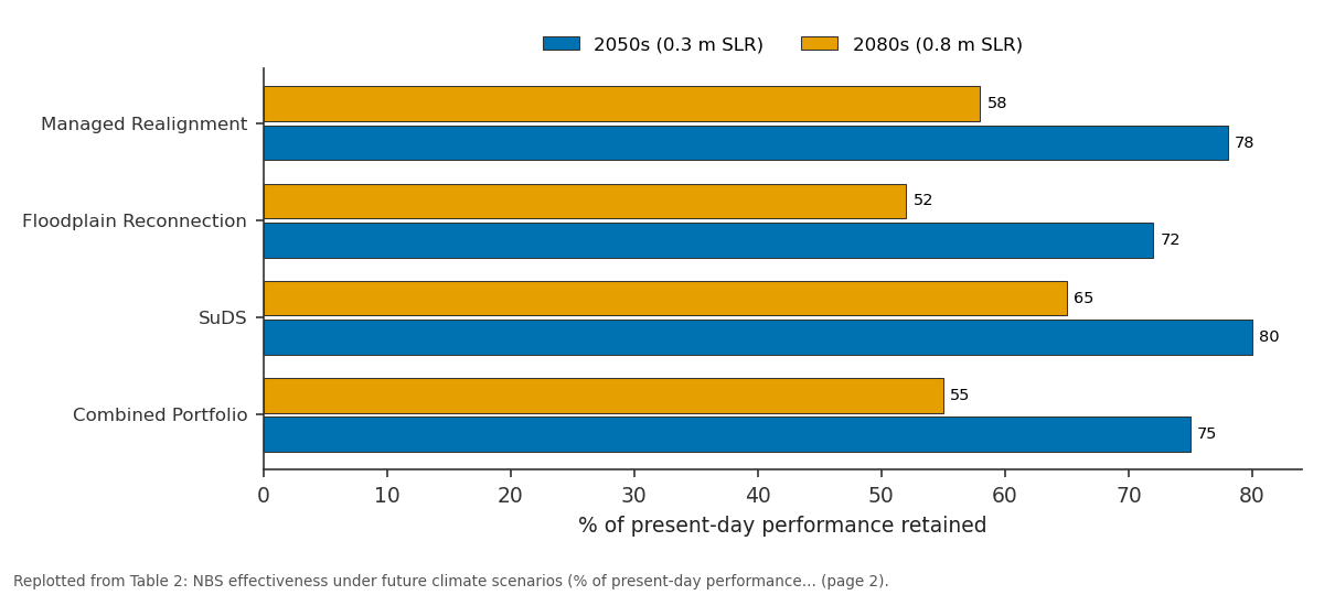
2050s (0.3 m SLR) and 2080s (0.8 m SLR): Managed Realignment vs Floodplain Reconnection vs SuDS vs Combined Portfolio
Replotted from Table 2 (page 2) of the original paper. Every bar is the paper's own table value.
View source evidence ↗Figures & tables
From the original paper Table 1
 Table 2
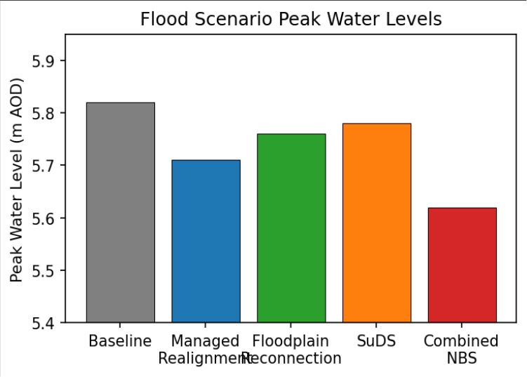 Figure 1
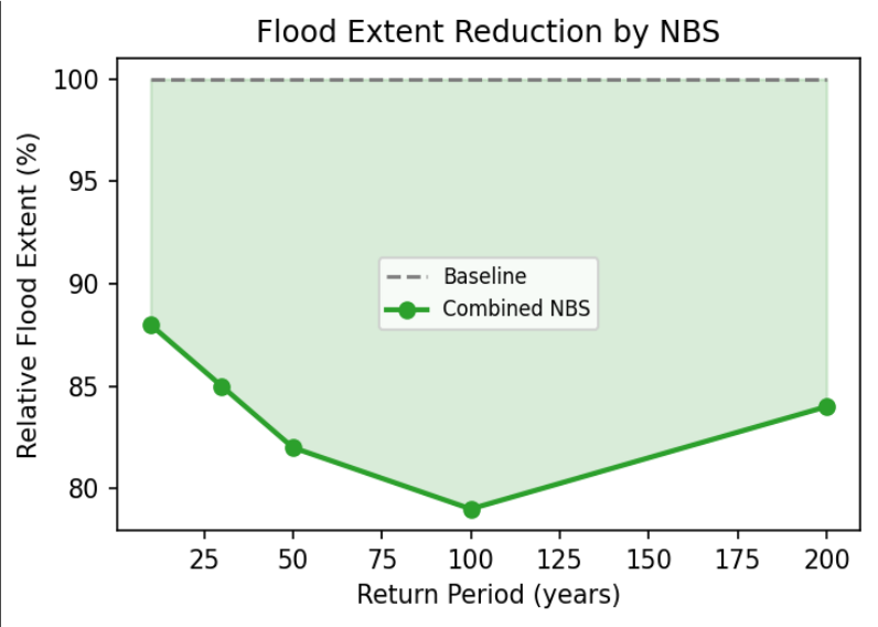 Figure 2
Introduction
Flood risk in the Thames Estuary affects over 1.3 million people and 500,000 properties, making it one of Europe's most significant flood risk concentrations [1] . The current defence system, centred on the Thames Barrier and associated walls, faces increasing pressure from sea level rise, changing storminess, and continued floodplain development. The Thames Estuary 2100 plan explicitly recognises NBS potential alongside conventional infrastructure [1, 2] . NBS encompass interventions that work with natural processes to manage flood risk, including wetland creation, floodplain restoration, and urban green infrastructure [3] . These offer co-benefits including habitat creation, water quality improvement, carbon sequestration, and recreational amenity that enhance the overall value proposition of flood management investments [4] . However, quantitative effectiveness in complex estuarine settings remains poorly established, as most evidence derives from simpler fluvial systems [5] . In estuarine settings, flood water levels are controlled by interactions between tidal propagation, fluvial discharge, storm surge, and local rainfall, creating compound flooding scenarios that single-mechanism NBS may not adequately address [6] . This research quantifies the flood mitigation potential of three NBS categories relevant to the estuarine context using process-based 2D hydrodynamic modelling [7] . The specific objectives are to evaluate each NBS category independently and in combination, assess the sensitivity of NBS effectiveness to compound event timing, test performance under future climate projections, and identify the synergistic interactions between different NBS categories that may enhance overall portfolio performance [8,9] .
Research Area Description
The model domain extends from Teddington Weir (tidal limit) to the Thames Barrier and 10 km downstream. The floodplain contains dense urban development, industrial land, and remnant marshland. Mean spring tidal range is 6.6 m at London Bridge. The area experiences compound flooding from tidal surge, fluvial discharge, and urban surface water interactions. The three managed realignment candidate sites are located on the south bank between Erith and Dartford, providing combined new intertidal area of 285 ha [1] .
Materials and Methods
Materials and Methods
Materials
Topographic data from Environment Agency LiDAR at 1 m resolution defined the computational mesh. Flood defence geometry from the National Flood and Coastal Defence Database represented embankments, walls, and gates as 1D elements within the 2D grid. Tidal boundary conditions were derived from the National Tidal and Sea Level Facility predictions. Fluvial inflows were obtained from Environment Agency gauging stations. The model was calibrated against the December 2013 tidal surge event, achieving RMSE of 5.2 cm for peak water levels and a spatial fit statistic of 0.87 for observed flood extent [1,10] .
Methods:
The TUFLOW 2D model used 5 m cells in urban areas and 25 m in floodplain areas. Three NBS scenarios were simulated independently and in combination: managed realignment at three sites, floodplain reconnection along two upstream reaches, and SuDS represented as distributed reduction in impervious runoff coefficients across 30% of the urbanised area. Future climate scenarios incorporated UKCP18 projections with sea level rise of 0.3 m (2050s) and 0.8 m (2080s), combined with 20% increase in peak fluvial discharge [7,11] .
Compound Event Timing Sensitivity
Factorial simulation combining different tidal states with varying fluvial magnitudes demonstrated that floodplain reconnection efficiency varied by a factor of two between most and least favourable conditions. Attenuation was maximised when floodplain inundation occurred during falling tide, allowing drainage during low tide, and minimised when flood peaks coincided with high tide, which limited available storage. This sensitivity underscores the importance of probabilistic assessment using joint probability of tidal and fluvial extremes [6,12] .
Results
Results
Comprehensive Interpretation
The combined portfolio produced benefits exceeding the arithmetic sum of individual interventions, confirming synergistic interactions between NBS categories addressing different components of the compound flood mechanism. Climate scenario testing revealed progressive effectiveness decline under higher sea level rise projections, indicating the need for adaptive scaling.
Discussion
The 8-14 cm water level reduction from managed realignment is significant in the Thames context where small changes affect large floodplain areas [1,2] . Economic analysis yielded benefit-cost ratios of 1.8-4.2, comparing favourably with hard engineering, particularly when cobenefits are monetised [3,4] . SuDS showed the lowest flood reduction ratio alone but substantial additional value for urban amenity and water quality [8] . While NBS alone cannot replace the Thames Barrier system, they provide valuable supplementary risk reduction and enhance climate resilience [5,9] . The compound event timing sensitivity highlights that deterministic design scenarios may substantially over-or underestimate NBS performance depending on the assumed tidal-fluvial phasing [6,12] . Future research should evaluate long-term morphodynamic evolution of managed realignment sites and the maintenance requirements for sustained NBS performance across multi-decadal planning horizons [13,14] .
Conclusion
NBS can provide meaningful flood risk reduction in the Thames Estuary when designed for estuarine complexity. Managed realignment is the most effective single intervention for tidal mitigation, while floodplain reconnection and SuDS address fluvial and pluvial components respectively. Combined implementation produces synergistic benefits supporting an integrated portfolio approach. Climate scenario testing indicates that NBS effectiveness will decline under future sea level rise, requiring adaptive scaling. The evidence presented here supports the integration of NBS into the Thames Estuary 2100 adaptive pathway framework, where they can serve as early-stage interventions that provide immediate benefits while more extensive engineered measures are planned for later decades.
Acknowledgement
Acknowledgements Funding SourcesThis research was supported by departmental research funds from the Department of Hydrogeology, Tanta University of Geosciences. No external grant numbers are associated with this work.
Figures and tables from the paper
| Scenario | Peak WL Reduction (cm) | Peak Flow Reduction (%) | Flood Extent Reduction (%) |
|---|---|---|---|
| Managed Realignment | 8-14 | — | 6-9 |
| Floodplain Reconnection | 2-4 | 5-11 | 3-5 |
| SuDS | 1-3 | — | 2-4 |
| Combined NBS | 16-22 | 8-15 | 11-16 |
Table text extracted from the original PDF; superscript letters are shown inline. The original table image is below.
View original table image
| Scenario | 2050s (0.3 m SLR) | 2080s (0.8 m SLR) |
|---|---|---|
| Managed Realignment | 78% | 58% |
| Floodplain Reconnection | 72% | 52% |
| SuDS | 80% | 65% |
| Combined Portfolio | 75% | 55% |
Table text extracted from the original PDF; superscript letters are shown inline. The original table image is below.
View original table image
References
16 in the original paper- Environment Agency. Thames Estuary 2100: managing flood risk through London. London: Environment Agency; 2012.
- Pontee N. Defining coastal squeeze: a discussion. Ocean and Coastal Management. 2013;84:204-207.
- Temmerman S, Meire P, Bouma TJ, et al. Ecosystembased coastal defence in the face of global change. Nature. 2013;504(7478):79-83.
- Narayan S, Beck MW, Reguero BG, et al. The effectiveness, costs and coastal protection benefits of natural and nature-based defences. PLoS ONE. 2016;11(5):e0154735.
- Dadson SJ, Hall JW, Murgatroyd A, et al. A restatement of the natural science evidence for catchment-based natural flood management. Proceedings of the Royal Society A. 2017;473:20160706.
- Zscheischler J, Westra S, van den Hurk BJJM, et al. Future climate risk from compound events. Nature Climate Change. 2018;8(6):469-477.
- Sayers P, et al. Flood risk management: a strategic approach. Manila: Asian Development Bank; 2013.
- Fletcher TD, Shuster W, Hunt WF, et al. SUDS, LID, BMPs, WSUD and more-the evolution and application of terminology. Urban Water Journal. 2015;12(7):525-542.
- Kabisch N, Korn H, Stadler J, Bonn A. Nature-based solutions to climate change adaptation in urban areas. Cham: Springer; 2017:1-337.
- BMT. TUFLOW user manual. Brisbane: BMT Commercial Australia Pty Ltd; 2018.
- Lowe JA, et al. UKCP18 science overview report. Exeter: Met Office Hadley Centre; 2018.
- Zheng F, Westra S, Leonard M, Sisson SA. Modeling dependence between extreme rainfall and storm surge. Water Resources Research. 2014;50(10):8117-8133.
- French PW. Managed realignment-the developing story of a comparatively new approach to soft engineering. Estuarine, Coastal and Shelf Science. 2006;67(3):409-423.
- Esteves LS. Managed realignment: a viable long-term coastal management strategy? Dordrecht: Springer; 2014:1-139.
- Nicholson AR, Wilkinson ME, O'Donnell GM, Quinn PF. Runoff attenuation features. Area. 2012;44(4):463469.
- Samuels PG, Klijn F, Dijkman J. Analysis of current river flood risk management policies. Irrigation and Drainage. 2006;55(S1):S141-S150.