
Research article · 2025 · Full text
International Journal of Geography Geology and EnvironmentHydrological response of headwater catchments to land use change in the Scottish highlands
Volume 7(11) · Pages 117–120 · DOI: 10.22271/27067483.2025.v7.i11b.678 ↗
Research areasHydrology and Watershed Management StudiesSoil erosion and sediment transportUrban Stormwater Management Solutions
Abstract
Author-writtenHeadwater catchments in the Scottish Highlands are undergoing significant land use transitions including afforestation, peat restoration, and grazing management changes, each with implications for downstream hydrology. This research examined the hydrological response of six paired headwater catchments in the north-central Highlands to contrasting land management scenarios over 2017-2023 using field monitoring and TOPMODEL simulations. Continuous rainfall, streamflow, soil moisture, and water table measurements were collected at each catchment. Peat restoration through drain blocking reduced peak flows by 12-18% and increased baseflow by 8-15% compared to drained counterparts. Coniferous afforestation reduced annual water yield by 15-22% through enhanced interception and transpiration but had negligible effect on flood peaks for events exceeding two-year return periods. Open moorland under traditional grouse moor management exhibited the flashiest hydrological response with shortest time to peak and highest specific peak flows. TOPMODEL scenario analysis confirmed that differences were attributable to land management rather than catchment physiography. A complete conversion to peat restoration predicted 15% reduction in the 10-year flood peak, while afforestation predicted 19% water yield reduction but only 6% peak reduction. These findings provide quantitative evidence for designing natural flood management strategies in upland environments.
Summary
Source-checkedPlain-language reading of the full paper, prepared with AI and checked against the text. Each point links to the authors' own words.
Why it matters
- The Scottish Highlands are a major semi-natural upland region in Western Europe featuring a mix of peatlands, heather moorland, native woodlands, and commercial coniferous forests. View evidence ↗
- Understanding the hydrology of this region is critical because it provides drinking water for about two-thirds of Scotland's population. View evidence ↗
- Due to significant flooding hazards, there is increasing interest in using land management as a form of natural flood management to complement traditional engineered defenses. View evidence ↗
The question
- The study aimed to examine how different land management scenarios affected the hydrological response of six paired headwater catchments in the north-central Highlands between 2017 and 2023. View evidence ↗
What they did
- The researchers selected six headwater catchments (1.8 to 5.2 km²) and grouped them into three pairs based on similar physical characteristics but different land management. View evidence ↗
- The three land use types compared were open heather moorland (grouse moor management), mature Sitka spruce plantations (25-40 years), and peat restoration sites where drains were blocked between 2012 and 2015. View evidence ↗
- Monitoring included 15-minute streamflow measurements via V-notch weirs, rainfall via tipping bucket gauges, soil moisture at three depths (10, 30, 60 cm), and water table depth via piezometers. View evidence ↗
- The TOPMODEL was used for scenario simulations of complete land use conversion, with calibration performed on the first four water years and validation on the final two. View evidence ↗
What they found
- Compared to drained areas, peat restoration via drain blocking reduced peak flows by 12-18% and increased baseflow by 8-15%. View evidence ↗
- Coniferous afforestation decreased annual water yield by 15-22% but did not significantly affect flood peaks for events with return periods greater than two years. View evidence ↗
- Open moorland managed for grouse showed the most rapid hydrological response, characterized by the highest specific peak flows and the shortest time to peak. View evidence ↗
- At a depth of 30 cm, restored peat catchments had a mean saturation of 82%, which was higher than drained moorland (68%) and forest (61%). View evidence ↗
What it means
- The authors conclude that peat restoration is the most effective natural flood management tool, whereas afforestation primarily impacts the availability of water resources. View evidence ↗
- The authors state that land management cannot replace engineered flood defenses for high-return-period events due to its limited effect on extreme floods. View evidence ↗
- The authors note that long-term monitoring is required to determine if these hydrological effects persist as forests grow and restored peatlands mature. View evidence ↗
Visual summary
3 visualsIllustrations explain the paper; charts are replotted from the paper's own table values.

Hydrological Response Comparison
AI-generated conceptual illustration (Scottish highland headwater catchments featuring peatland, coniferous forest, and open moorland). It explains the idea and does not show study data.
View source evidence ↗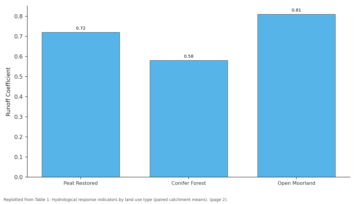
Runoff Coefficient: Peat Restored vs Conifer Forest vs Open Moorland
Replotted from Table 1 (page 2) of the original paper. Every bar is the paper's own table value.
View source evidence ↗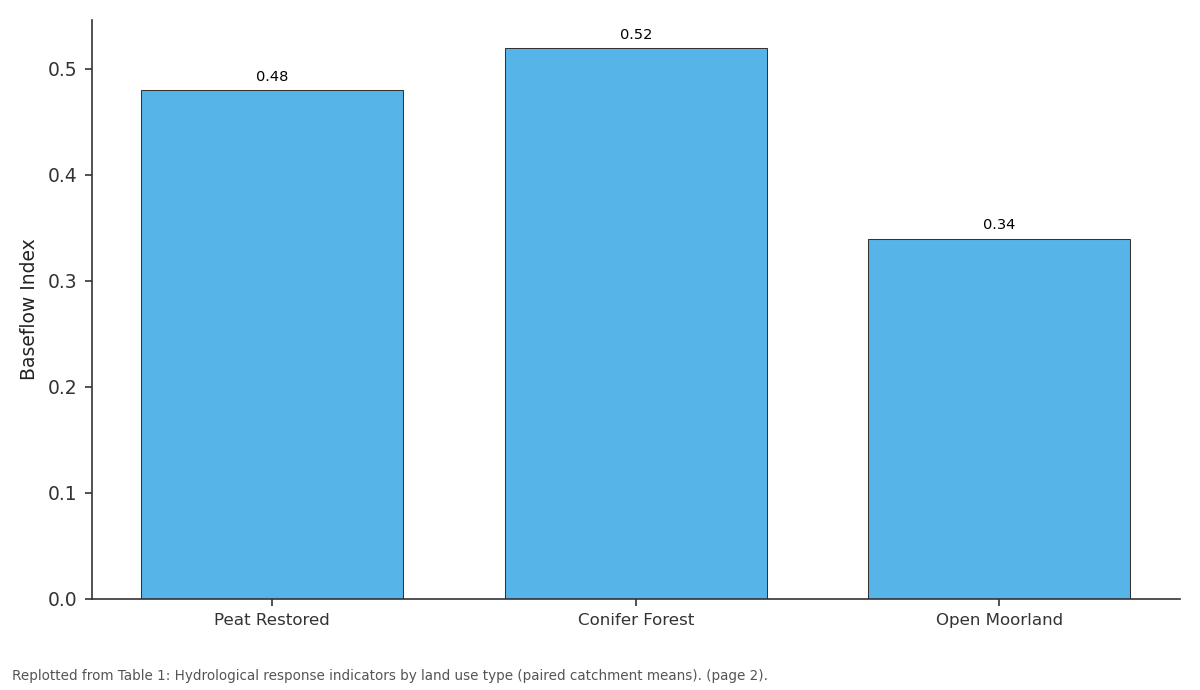
Baseflow Index: Peat Restored vs Conifer Forest vs Open Moorland
Replotted from Table 1 (page 2) of the original paper. Every bar is the paper's own table value.
View source evidence ↗Figures & tables
From the original paper Table 1
 Table 2
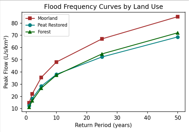 Figure 1
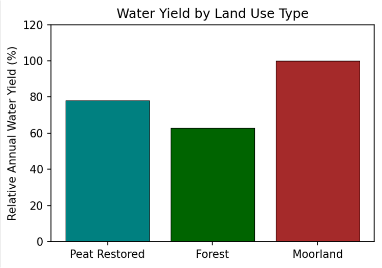 Figure 2
Introduction
The Scottish Highlands encompass one of the largest semi-natural upland landscapes in Western Europe, characterised by extensive peatlands, heather moorland, and remnant native woodland interspersed with commercial coniferous plantations [1] . These landscapes provide critical ecosystem services including water supply, carbon storage, biodiversity support, and flood risk regulation. Over the past century, hydrological functioning has been substantially modified by widespread peatland drainage, commercial afforestation with non-native conifers, intensification of grazing, and more recently, peatland restoration initiatives [2,3] . Understanding land use effects on hydrology is essential for several reasons. The Highlands supply drinking water to approximately two-thirds of Scotland's population, and changes in yield, quality, and timing directly affect resource management [4] . Flooding is a significant hazard, and there is growing interest in land management changes complementing engineered defences as natural flood management [5] . The Scottish Government has committed to ambitious peatland restoration targets for climate mitigation, and the hydrological consequences need quantification [6] . Previous research produced mixed results, partly due to differences in experimental design and site characteristics. Classical paired catchment experiments at Plynlimon and Coalburn established that coniferous afforestation reduces annual water yield [7] , but effects on flood peaks remain contested [8] . Research on peatland restoration suggests drain blocking can increase storage and attenuate peaks, though evidence is limited [3,9] . This research contributes six-year results from a paired catchment experiment comparing peat restoration, coniferous plantation, and open moorland. The research employs both empirical analysis and TOPMODEL simulations to isolate land use effects from climatic variability and physiographic differences, providing quantitative evidence for natural flood management design [10,11] ..
Research Area Description
Six headwater catchments were selected in the north-central Highlands, ranging from 1.8 to 5.2 km², grouped into three pairs sharing similar geology, elevation range, and aspect but differing in management. The three land use types were: peat restoration sites (drains blocked 2012-2015), mature Sitka spruce plantations (25-40 years), and open heather moorland under grouse moor management. Elevation ranges from 280 to 720 m. Annual precipitation averages 1,400-1,800 mm, and the substrate is predominantly peat overlying glacial till on Dalradian metamorphic bedrock [1,2] .
Materials and Methods
Materials and Methods
Materials
Each catchment was instrumented with a calibrated V-notch weir with pressure transducer for 15-minute streamflow measurement. Rainfall was measured by tipping bucket gauges at two locations per catchment. Soil moisture was monitored by TDR sensors at 10, 30, and 60 cm depths at three hillslope positions. Water table depth was recorded by piezometers in peat deposits. Data were collected continuously from October 2017 to September 2023, providing six complete water years [9,10] .
Methods
Hydrological indices including runoff coefficient, baseflow index, time to peak, and flow duration curves were computed. Flood frequency analysis used the generalised logistic distribution fitted to annual maxima. TOPMODEL was calibrated on the first four water years and validated on the remaining two. Scenario simulations assessed the effect of hypothetical complete land use conversion across each catchment to quantify management-attributable hydrological changes independently of physiographic variation [11,12] .
Soil Moisture and Water Table Dynamics
Restored peat catchments maintained consistently higher moisture at 30 cm (mean 82% saturation) compared to drained moorland (68%) and forest (61%). Water table depth averaged 8 cm below surface during the wet season and 24 cm in summer for restored sites, versus 22 cm and 48 cm for drained catchments. These differences confirm that drain blocking effectively raises the water table and increases peat storage capacity, providing the mechanism for the observed peak flow attenuation [3,9] . Moorland catchments consistently produced the highest peak flows (Figure 1). Differences were significant for events up to the 5-year return period but diminished for rarer events as canopy interception becomes proportionally less significant with increasing storm magnitude.
Results
Results
Comprehensive Interpretation
Field monitoring and modelling consistently demonstrate that peat restoration offers the most effective natural flood management measure, while afforestation primarily affects water resource availability. The trade-off between flood mitigation and water supply objectives requires explicit consideration in catchment land use planning decisions.
Discussion
The 12-18% peak flow attenuation from peat restoration is consistent with UK upland experiments [3,9] . The mechanism involves increased water storage in blocked drains and recovering Sphagnum moss communities that intercept precipitation otherwise conveyed rapidly to channels. The 15-22% water yield reduction from afforestation matches published estimates for coniferous forest [7,8] and reflects combined canopy interception and root zone transpiration losses concentrated during summer months.
The TOPMODEL scenario analysis confirmed management attribution independently of physiographic factors, strengthening the causal interpretation. The finding that peat restoration reduces flood peaks more effectively than afforestation while having minimal impact on water yield has direct policy relevance for Scotland's Natural Flood Management programme [5,6] . However, the limited effect on extreme events suggests that land management alone cannot substitute for engineered flood defences for highreturn-period design standards [10,13,14] .
Conclusion
Peat restoration through drain blocking offers a practical nature-based solution for flood peak attenuation with cobenefits for baseflow maintenance and carbon sequestration. The 12-18% peak reduction for moderate events is operationally significant for downstream communities.
Afforestation with conifers significantly reduces water yield, which may conflict with supply objectives in catchments feeding reservoirs. The trade-off between flood management and water supply must be explicitly addressed in catchment planning.
Long-term monitoring is essential to assess the durability of these effects as restored peatlands mature and planted forests progress through their growth cycle. Future research should quantify the carbon sequestration co-benefits alongside the hydrological effects to support integrated costbenefit analysis of natural flood management interventions.
Acknowledgement
Acknowledgements Funding SourcesThis research was supported by departmental research funds from the Department of Applied Geology, Durban Centre for Geological Research. No external grant numbers are associated with this work.
Figures and tables from the paper
| Indicator | Peat Restored | Conifer Forest | Open Moorland |
|---|---|---|---|
| Runoff Coefficient | 0.72 | 0.58 | 0.81 |
| Baseflow Index | 0.48 | 0.52 | 0.34 |
| Time to Peak (hr) | 4.8 | 5.2 | 2.9 |
| Water Yield (mm/yr) | 1,180 | 920 | 1,210 |
| Peak Reduction vs Moor | 12-18% | 4-8% | Baseline |
| Baseflow Increase vs Moor | 8-15% | 2-5% | Baseline |
Table text extracted from the original PDF; superscript letters are shown inline. The original table image is below.
View original table image
| Conversion Scenario | 10-yr Peak Change | Annual Yield Change | Baseflow Change |
|---|---|---|---|
| Moorland → Peat Restoration | −15% | −3% | +12% |
| Moorland → Conifer Forest | −6% | −19% | +4% |
| Peat Restoration → Conifer | +8% | −17% | −7% |
Table text extracted from the original PDF; superscript letters are shown inline. The original table image is below.
View original table image
References
13 in the original paper- Werritty A. Living with uncertainty: climate change, river flows and water resource management. Science of the Total Environment. 2002;294(1-3):29-40.
- Holden J, Chapman PJ, Labadz JC. Artificial drainage of peatlands: hydrological and hydrochemical process. Progress in Physical Geography. 2004;28(1):95-123.
- Wilson L, Wilson J, Holden J, et al. Ditch blocking, water chemistry and organic carbon flux. Science of the Total Environment. 2011;409(19):3827-3837.
- SEPA. River basin management plan for Scotland: 2015-2027. Edinburgh: Scottish Environment Protection Agency; 2015.
- Dadson SJ, Hall JW, Murgatroyd A, et al. A restatement of the natural science evidence concerning catchment-based natural flood management. Proceedings of the Royal Society A. 2017;473(2199):20160706.
- Scottish Government. Scotland's National Peatland Plan: working for our future. Edinburgh: Scottish Natural Heritage; 2015.
- Robinson M, et al. Impacts of forests on peak flows and baseflows: a European perspective. Forest Ecology and Management. 2003;186(1-3):85-97.
- Calder IR, Aylward B. Forest and floods: moving to an evidence-based approach to watershed and integrated flood management. Water International. 2006;31(1):8799.
- Parry LE, Holden J, Chapman PJ. Restoration of blanket peatlands. Journal of Environmental Management. 2014;133:193-205.
- Lane SN, Milledge DG. Impacts of upland open drains upon runoff generation. Hydrological Processes. 2013;27(12):1701-1726.
- Beven KJ, Kirkby MJ. A physically based, variable contributing area model. Hydrological Sciences Bulletin. 1979;24(1):43-69.
- Quinn P, Beven K, Chevallier P, Planchon O. The prediction of hillslope flow paths for distributed hydrological modelling. Hydrological Processes. 1991;5(1):59-79.
- Soulsby C, Tetzlaff D, Hrachowitz M. Tracers and transit times: windows for viewing catchment scale storage. Hydrological Processes. 2009;23(24):35033507.