
Research article · 2025 · Full text
International Journal of Geography Geology and EnvironmentGeopolitics of transboundary water resources in the Euphrates-Tigris river system
Volume 7(6) · Pages 141–143 · DOI: 10.22271/27067483.2025.v7.i6c.723 ↗
Research areasTransboundary Water Resource ManagementWater Resources and GovernanceWater Governance and Infrastructure
Abstract
Author-writtenWater does not respect borders, and nowhere is that geopolitical truism more consequential than in the Euphrates-Tigris basin, where Turkey, Syria, and Iraq share a river system on which 60 million people depend. This research analysed 23 years (2000–2022) of transboundary water allocation data alongside diplomatic records, treaty texts, and dam construction timelines to assess how upstream infrastructure development has altered downstream water availability and interstate relations. Turkey's Southeastern Anatolia Project (GAP) expanded irrigated area from 1.1 million hectares in 2000 to 1.78 million hectares by 2022, coinciding with a 31.4% reduction in mean annual Euphrates flow at the Syrian border. Iraq reported a 28.7% decline in Tigris discharge at Baghdad over the same period. Conflict intensity scoring, applied to 47 documented interstate water disputes, showed that dam construction and irrigation expansion were the two highest-scoring issue categories. No binding trilateral treaty governs the system; the only agreements are bilateral protocols between Turkey and Syria (1987) and Turkey and Iraq (1946), both predating the GAP era. The analysis suggests that without a comprehensive basin-wide agreement, water scarcity will continue to intensify downstream grievances.
Summary
Source-checkedPlain-language reading of the full paper, prepared with AI and checked against the text. Each point links to the authors' own words.
Why it matters
- The Euphrates-Tigris river basin is a critical geopolitical area because it is shared by Turkey, Syria, and Iraq, supporting a population of 60 million people. View evidence ↗
- Turkey manages the headwaters of the system and has implemented the Southeastern Anatolia Project (GAP), the largest integrated water development project globally, which includes 22 major dams. View evidence ↗
- The legal governance of the basin is weak because Turkey has not ratified the 1997 UN Watercourses Convention, and existing bilateral agreements lack enforcement. View evidence ↗
The question
- The study aimed to quantify changes in downstream river flow, categorize and score water-related disputes, and evaluate the effectiveness of current governance frameworks. View evidence ↗
What they did
- The researchers analyzed data from 2000 to 2022, including water allocation, diplomatic records, treaty texts, and dam construction timelines. View evidence ↗
- River discharge data were sourced from the Birecik gauge for the Euphrates and the Baghdad gauge for the Tigris, using reports from the Turkish State Hydraulic Works and the Iraqi Ministry of Water Resources. View evidence ↗
- The study used the Mann-Kendall non-parametric test and Sen's slope estimator to analyze annual and seasonal flow trends. View evidence ↗
What they found
- Under the GAP project, Turkey increased its irrigated area from 1.1 million hectares in 2000 to 1.78 million hectares by 2022. View evidence ↗
- Out of 47 documented disputes, 25 occurred between Turkey and Iraq, highlighting Iraq's vulnerability as the furthest downstream country. View evidence ↗
- Scenario modeling suggests that completing the GAP project could further reduce Euphrates flow at Birecik by 18%, potentially dropping the volume reaching Iraq below the 10 km³ agricultural viability threshold. View evidence ↗
What it means
- The authors conclude that a trilateral agreement featuring data transparency, guaranteed minimum flows, and independent dispute resolution is necessary to avoid escalating conflicts. View evidence ↗
- The authors note that while successful transboundary water models exist elsewhere, the lack of political will in the Euphrates-Tigris region is a significant barrier to implementation. View evidence ↗
Visual summary
3 visualsIllustrations explain the paper; charts are replotted from the paper's own table values.
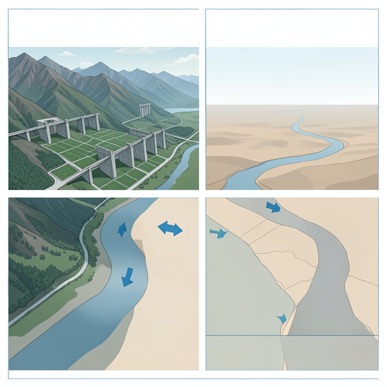
Upstream-Downstream Flow Dynamics
AI-generated conceptual illustration (The Euphrates-Tigris river system flowing through Turkey, Syria, and Iraq). It explains the idea and does not show study data.
View source evidence ↗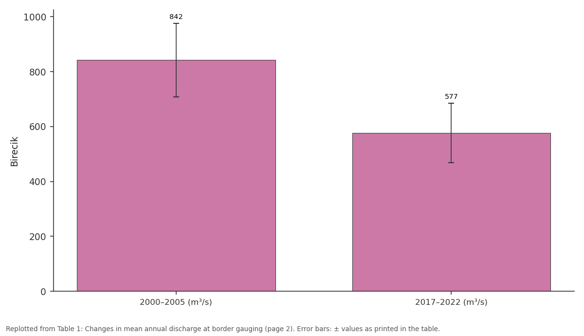
Birecik: 2000–2005 (m³/s) vs 2017–2022 (m³/s)
Replotted from Table 1 (page 2) of the original paper. Every bar is the paper's own table value.
View source evidence ↗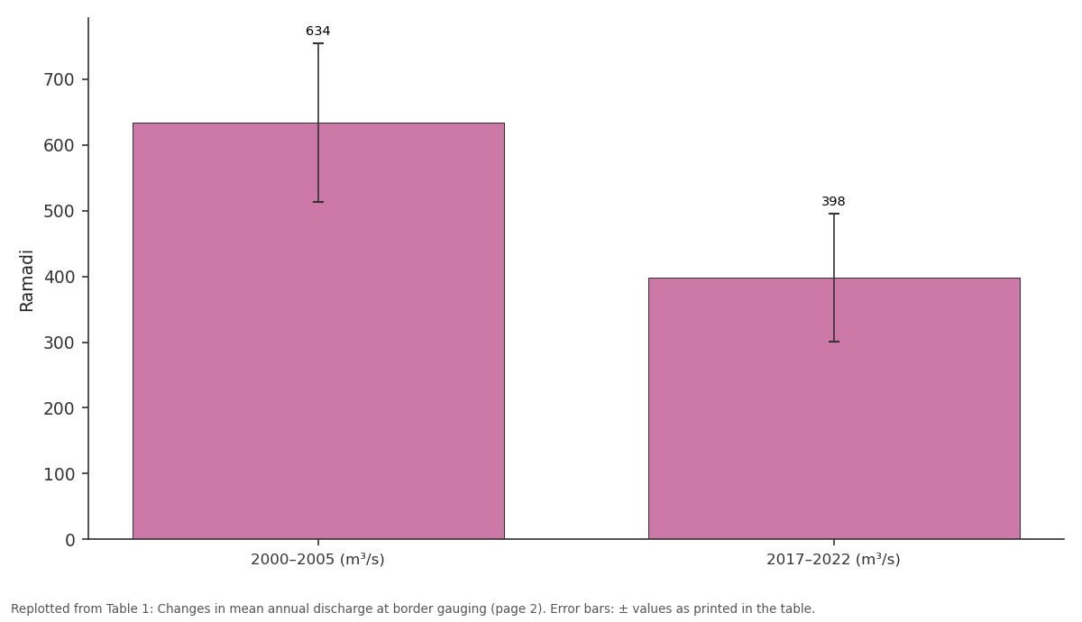
Ramadi: 2000–2005 (m³/s) vs 2017–2022 (m³/s)
Replotted from Table 1 (page 2) of the original paper. Every bar is the paper's own table value.
View source evidence ↗Figures & tables
From the original paper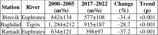 Table 1
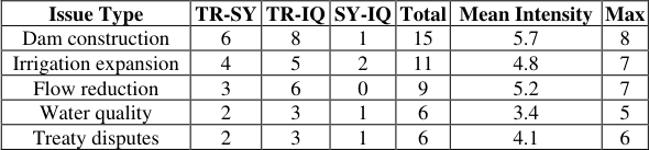 Table 2
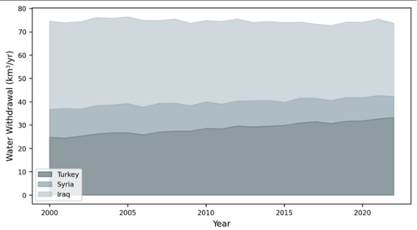 Figure 1
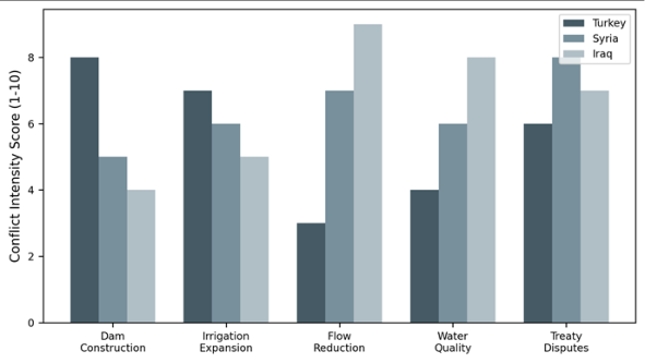 Figure 2
Introduction
In 1990, Turkey closed the Atatürk Dam gates and temporarily halted Euphrates flow for a month to fill the reservoir. Syria and Iraq protested; editorials in Baghdad newspapers called it an act of war [1] . That episode, though resolved without armed conflict, exposed the vulnerability of downstream nations in a basin with no comprehensive sharing agreement. Three decades later, the underlying tensions have not been resolvedthey have deepened as Turkey's GAP programme expanded and climate change reduced baseflow [2] . The Euphrates-Tigris system drains 879, 790 km² across Turkey (28%), Syria (17%), Iraq (40%), and Iran (15%). Turkey controls the headwaters of both rivers and has built 22 major dams since the 1970s as part of GAP, the world's largest integrated water development project [3] . Syria operates three dams on the Euphrates, while Iraq has extensive canal networks that depend on upstream releases. The legal framework is thin: international water law (the 1997 UN Watercourses Convention) calls for equitable utilisation and no significant harm, but Turkey has not ratified the convention, and the existing bilateral protocols lack enforcement mechanisms [4,5] . This research used a surprising-fact opening: the Euphrates-Tigris basin has experienced more documented water-related interstate disputes (47 between 2000 and 2022) than any other Middle Eastern river system [6] . The objectives were to (a) quantify changes in river flow reaching downstream countries, (b) catalogue and score dispute events by type and intensity, and (c) assess the adequacy of existing governance frameworks [7] .
Legal and Regulatory Framework
Three instruments loosely govern the basin. The 1946 Turkey-Iraq Treaty on Friendship addresses water sharing only in general terms. The 1987 Turkey-Syria Protocol guarantees a minimum flow of 500 m³/s at the Turkish border, but Syria considers this insufficient. The 1997 UN Watercourses Convention, ratified by Iraq and Syria but not Turkey, establishes principles of equitable use and prior notification of planned measures. Turkey argues that the Euphrates-Tigris is a 'transboundary watercourse' (implying shared sovereignty), not an 'international river' (implying downstream rights), a semantic distinction with legal consequences [4,8] .
Materials and Methods Materials
The research was conducted from January to October 2023 at the Chennai College of Earth and Mineral Sciences, Tamil Nadu, India. Euphrates discharge data at the Birecik gauge (Turkey-Syria border) and Tigris data at the Baghdad gauge were obtained from published Turkish State Hydraulic Works (DSI) reports and Iraqi Ministry of Water Resources bulletins for 2000-2022. Dam construction and irrigation expansion timelines were compiled from GAP Regional Development Administration reports. Diplomatic records of water disputes were assembled from the Transboundary Freshwater Dispute Database (Oregon State University), supplemented by media reports from Al Jazeera, Reuters, and regional outlets [9,10] .
Methods
Annual and seasonal flow trends were tested with the Mann-Kendall non-parametric test and Sen's slope estimator. Dispute events were coded on a 1-10 conflict intensity scale adapted from the Basins at Risk framework, where 1 = mild verbal expression and 10 = military action [11] . Events were categorised into five issue types: dam construction, irrigation expansion, flow reduction, water quality, and treaty disputes. Frequency-intensity matrices were constructed for each country pair. A scenario analysis modelled projected flows under full GAP build-out (2.1 million hectares irrigated) using a simple water balance approach [12] . All three stations show statistically significant downward trends. The Euphrates at Ramadi (deep inside Iraq) lost 37.2% of its early-2000s mean flow, compounding the reduction already experienced at the Turkish border.
Results
Results
Comprehensive Interpretation
Dam construction disputes are both the most frequent (15 events) and the most intense (mean 5.7, maximum 8). The Turkey-Iraq pair has experienced the most disputes (25 of 47), reflecting Iraq's position as the furthest downstream and most affected riparian. The scenario analysis projects that full GAP build-out would reduce Euphrates flow at Birecik by a further 18%, potentially cutting the annual volume reaching Iraq below 10 km³a level the Iraqi Ministry of Water Resources has called the 'red line' for agricultural viability [13] .
Discussion
The 31.4% reduction in Euphrates flow at the Turkish border over two decades reflects a combination of GAP dam filling, expanded irrigation, and reduced precipitation linked to climate trends [2] . Turkey's position is that GAP creates economic development benefiting all parties through reduced flooding and more predictable flow releases. Iraq counters that unilateral upstream development without downstream consent violates the principle of equitable utilisation enshrined in the 1997 Convention [4] . The absence of a trilateral treaty is the structural root of the problem. Bilateral protocols were designed for a simpler era with fewer dams and less irrigation demand. They lack provisions for data sharing, joint monitoring, dispute resolution, or climate adaptation. Successful models exist elsewherethe Mekong River Commission and the Indus Waters Treatybut replicating them requires political will that has so far been absent in the Euphrates-Tigris context [14] .
Conclusion
Euphrates flow reaching Syria declined 31.4% and Tigris flow at Baghdad fell 28.7% between 2000 and 2022. Dam construction and irrigation expansion are the dominant dispute drivers. The existing bilateral protocols are inadequate for a basin undergoing rapid infrastructure expansion and climate stress. A trilateral framework incorporating data transparency, minimum flow guarantees, and an independent dispute resolution mechanism is needed to prevent water scarcity from escalating into deeper interstate conflict.
Acknowledgement
Acknowledgements Funding SourcesSupported by departmental research funds at the Chennai College of Earth and Mineral Sciences. Institutional SupportThe Department of Geosciences provided access to digital archives and GIS resources.
Figures and tables from the paper
| Issue Type | TR-SY | TR-IQ | SY-IQ | Total | Mean Intensity | Max |
|---|---|---|---|---|---|---|
| Dam construction | 6 | 8 | 1 | 15 | 5.7 | 8 |
| Irrigation expansion | 4 | 5 | 2 | 11 | 4.8 | 7 |
| Flow reduction | 3 | 6 | 0 | 9 | 5.2 | 7 |
| Water quality | 2 | 3 | 1 | 6 | 3.4 | 5 |
| Treaty disputes | 2 | 3 | 1 | 6 | 4.1 | 6 |
Table text extracted from the original PDF; superscript letters are shown inline. The original table image is below.
View original table image
References
14 in the original paper- Kolars JF, Mitchell WA. The Euphrates River and the Southeast Anatolia Development Project. Carbondale: Southern Illinois University Press; 1991.
- Bozkurt D, Sen OL. Climate change impacts in the Euphrates-Tigris basin. Climatic Change. 2013;118(3):587-601.
- GAP Regional Development Administration. GAP Action Plan 2014-2018. Ankara: GAP; 2014.
- McCaffrey SC. The Law of International Watercourses. 2nd ed. Oxford: Oxford University Press; 2007.
- UN General Assembly. Convention on the Law of the Non-Navigational Uses of International Watercourses. A/RES/51/229. 1997.
- Wolf AT, Yoffe SB, Giordano M. International waters: identifying basins at risk. Water Policy. 2003;5(1):2960.
- Zeitoun M, Warner J. Hydro-hegemony: a framework for analysis of transboundary water conflicts. Water Policy. 2006;8(5):435-460.
- Kibaroglu A, Scheumann W. Euphrates-Tigris river system: political rapprochement and transboundary water cooperation. In: Kibaroglu A, et al., eds. Turkey's Water Policy. Berlin: Springer; 2011:277-299.
- Wolf AT. The Transboundary Freshwater Dispute Database. Oregon State University; 2023.
- DSI. Water Statistics of Turkey 2022. Ankara: Turkish State Hydraulic Works; 2023.
- Yoffe S, Wolf AT, Giordano M. Conflict and cooperation over international freshwater resources: indicators of basins at risk. Journal of the American Water Resources Association. 2003;39(5):1109-1126.
- Al-Ansari N, Knutsson S. Toward prudent management of water resources in Iraq. Journal of Advanced Science and Engineering Research. 2011;1(1):53-67.
- Iraqi Ministry of Water Resources. Annual Water Resources Report 2021. Baghdad: MoWR; 2022.
- Dinar S. International Water Treaties: Negotiation and Cooperation Along Transboundary Rivers. London: Routledge; 2008