
Research article · 2025 · Full text
International Journal of Geography Geology and EnvironmentGeotechnical properties of laterite soils and engineering implications in the Congo Basin
Volume 7(1) · Pages 136–139 · DOI: 10.22271/27067483.2025.v7.i1c.618 ↗
Research areasGeotechnical and construction materials studiesGeotechnical Engineering and Soil MechanicsSoil and Unsaturated Flow
Abstract
Author-writtenLaterite soils blanket much of the Congo Basin, yet their geotechnical behaviour remains poorly documented compared with laterites in South Asia and West Africa—a gap that has led to repeated foundation failures in rapidly urbanising Congolese cities. This research characterised the index properties, compaction characteristics, and shear strength of laterite soils at 48 locations across two provinces of the Democratic Republic of the Congo. Liquid limits ranged from 36.4% to 83.7%, and plasticity indices from 12.1% to 48.3%, placing most samples above the A-line on the Casagrande chart and classifying them as inorganic clays of medium to high plasticity. Maximum dry density decreased with increasing fines content (r = -0.79), while optimum moisture content increased correspondingly. Unconfined compressive strength varied from 78 to 312 kPa, with the lowest values in the upper 1-m horizon where iron-oxide cementation was weakest. The results provide design parameters for shallow foundations and road subgrades and highlight the need for site-specific testing in areas where laterite profiles are thicker than 3 m.
Summary
Source-checkedPlain-language reading of the full paper, prepared with AI and checked against the text. Each point links to the authors' own words.
Why it matters
- Laterite soils are widespread in the Congo Basin, but a lack of geotechnical documentation has contributed to frequent foundation failures in urban areas. View evidence ↗
- Laterites are tropical soils rich in aluminium and iron oxides, exhibiting engineering behaviors that differ significantly from the temperate soils typically found in textbooks. View evidence ↗
- In the Congo Basin, laterite profiles can be over 20 meters thick, transitioning from a hard surface duricrust to a mottled zone and finally to saprolite. View evidence ↗
The question
- The study aimed to systematically characterize the strength and index properties of laterite soils across 48 sites in two provinces. View evidence ↗
- The research also sought to evaluate how these properties change with depth and fines content to provide region-specific design recommendations for road subgrades and shallow foundations. View evidence ↗
What they did
- Between May and November 2022, researchers collected 192 disturbed and 96 undisturbed samples from 48 trial pits in the Kongo Central and Kinshasa provinces. View evidence ↗
- Disturbed samples were used for compaction, specific gravity, Atterberg limits, and grain-size analysis, while undisturbed samples were used for direct shear and unconfined compressive strength (UCS) tests. View evidence ↗
- UCS tests used cylindrical specimens (38 mm diameter, 76 mm height) at natural moisture, and direct shear tests were conducted at 0.5 mm/min under normal stresses of 50, 100, and 200 kPa. View evidence ↗
- Trial pits were dug to a maximum of 4 meters or until saprolite was reached, with samples collected every 0.5 meters. View evidence ↗
What they found
- The soils were classified as inorganic clays of medium to high plasticity, with plasticity indices between 12.1% and 48.3% and liquid limits between 36.4% and 83.7%. View evidence ↗
- The unconfined compressive strength (UCS) increased nearly threefold, rising from 112 kPa at the surface to 297 kPa at a depth of 4 meters. View evidence ↗
- There was a strong inverse correlation (r = -0.79) between fines content and maximum dry density, with optimum moisture content increasing as fines increased. View evidence ↗
- Strip footings on medium-plasticity laterites (PI < 25%) were 12% cheaper than using imported fill, but high-plasticity profiles (PI > 35%) increased costs by 18-27% due to required heave-mitigation. View evidence ↗
What it means
- The authors recommend founding shallow structures at least 1.5 meters deep to avoid weak surface layers, using fines content to assess road subgrade compaction, and applying lime stabilization for high-plasticity surface soils. View evidence ↗
- While the data serves as a regional reference for preliminary design, the authors state that site-specific testing is still required for larger structures. View evidence ↗
Visual summary
2 visualsIllustrations explain the paper; charts are replotted from the paper's own table values.
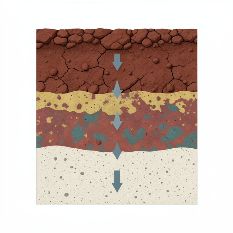
Laterite Profile Gradient
AI-generated conceptual illustration (laterite soil profile in the Congo Basin). It explains the idea and does not show study data.
View source evidence ↗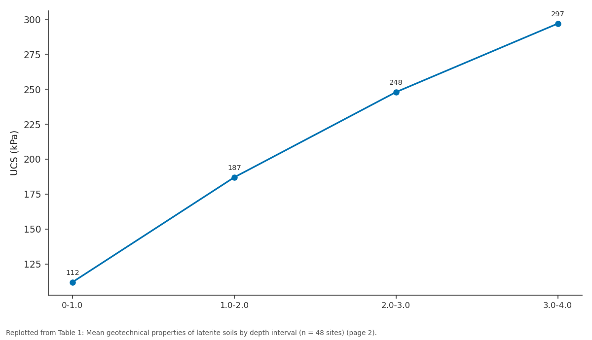
UCS (kPa): 0-1.0 vs 1.0-2.0 vs 2.0-3.0 vs 3.0-4.0
Replotted from Table 1 (page 2) of the original paper. Every bar is the paper's own table value.
View source evidence ↗Figures & tables
From the original paper Table 1
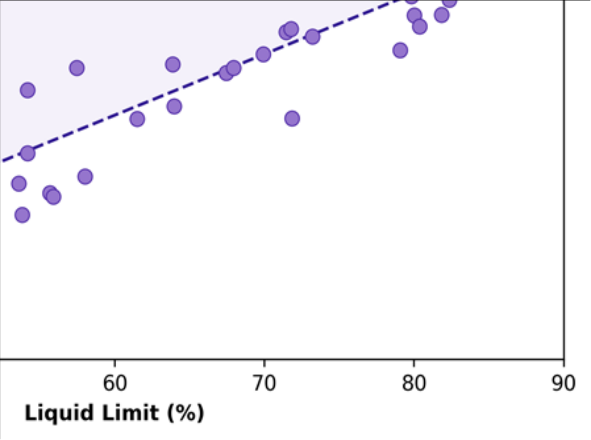 Figure 1
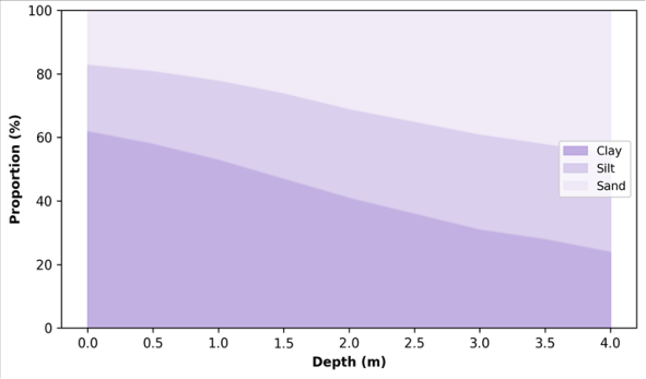 Figure 2
Introduction
A trend that has caught the attention of civil engineers across central Africa is the rising number of building failures on laterite foundations-failures that are often blamed on poor construction quality but may in fact originate in a misunderstanding of the soil itself [1] . Laterites are deeply weathered tropical soils rich in iron and aluminium oxides, and their engineering behaviour can differ drastically from that of temperate-climate soils that dominate geotechnical textbooks [2] . In the Congo Basin, laterite profiles can exceed 20 m in thickness, grading from a hard, ironcemented duricrust at the surface through a mottled zone of alternating soft and hard layers into a saprolite that retains the fabric of the parent rock [3] . Which horizon a foundation bears on-and how that horizon responds to seasonal wetting and drying-determines performance. Yet published geotechnical data for Congolese laterites are scattered across a handful of project reports, most of which are not publicly accessible [4] . Internationally, laterite geotechnics draws on extensive datasets from India, Nigeria, and Brazil, where Atterberg limits, compaction curves, and California Bearing Ratio (CBR) values have been compiled for hundreds of sites [5] . These databases show that laterite properties vary widely depending on parent rock, degree of weathering, drainage conditions, and iron-oxide mineralogy-making it risky to extrapolate from one region to another without local calibration [6] .
This research aimed to a) Systematically characterise the index and strength properties of laterite soils at 48 sites across two provinces. b) Evaluate how those properties vary with depth and fines content. c) Provide design recommendations for shallow foundations and road subgrades appropriate to the Congo Basin context [7] .
Baseline Soil Characterisation
Disturbed and undisturbed samples were collected from hand-dug trial pits at 48 locations in the Kinshasa and Kongo Central provinces. Pits extended to a maximum depth of 4 m or to the top of the saprolite, whichever was shallower. Each pit was logged following BS 5930 conventions, and samples were taken at 0.5-m depth intervals. In-situ moisture content averaged 24.3% in the upper 1 m and dropped to 18.6% below 2 m. Specific gravity, determined by pycnometer, ranged from 2.61 to 2.78, with higher values in the iron-rich duricrust horizon where goethite and hematite concentrations exceeded 35% by weight [3] . The natural void ratio decreased with depth from 1.14 near the surface to 0.72 at 3.5 m, reflecting progressive compaction and cementation.
Engineering Cost Implications
Foundation cost estimates were calculated for three common building types in the research area: single-storey residential (strip footing), two-storey commercial (pad footing), and low-rise institutional (raft foundation). On laterite profiles classified as medium plasticity (PI < 25%), conventional strip footings at 0.8-m depth satisfied allowable bearingcapacity criteria at a cost roughly 12% lower than on imported granular fill. However, on high-plasticity profiles (PI > 35%), heave-mitigation measures-including deeper founding levels, lime stabilisation, or compacted gravel pads-added 18-27% to foundation costs [5] . These estimates suggest that accurate soil classification at the project stage can avoid both under-design (leading to settlement) and over-design (wasting construction budget).
Material and Methods
Material and Methods
Methods
Grain-size distribution was determined by wet sieving and hydrometer analysis following ASTM D422. Liquid limit (LL) and plastic limit (PL) followed the Casagrande cup and rolling-thread methods (ASTM D4318). Compaction used the standard Proctor test (ASTM D698). UCS was measured on cylindrical specimens 38 mm in diameter and 76 mm in height at natural moisture content. Direct shear tests (ASTM D3080) were run under normal stresses of 50, 100, and 200 kPa at a displacement rate of 0.5 mm/min. Pearson correlation was used to relate index properties to depth and fines content [6] . Classification followed the Unified Soil Classification System (USCS).
Results
Table Figure 2 illustrates the gradual shift from clay-dominated surface horizons (62% clay) to sand-enriched lower horizons (45% sand at 4 m). This textural gradient mirrors the geotechnical trend in Table 1 and reflects the weathering intensity profile, with the most altered material at the surface.
| Depth (m) | LL (%) | PI (%) | Fines (%) | MDD (kg/m³) | OMC (%) | UCS (kPa) |
|---|---|---|---|---|---|---|
| 0-1.0 | 62.4 | 34.7 | 68.3 | 1,524 | 21.8 | 112 |
| 1.0-2.0 | 54.8 | 28.3 | 58.7 | 1,612 | 18.4 | 187 |
| 2.0-3.0 | 47.1 | 22.6 | 49.1 | 1,698 | 15.7 | 248 |
| 3.0-4.0 | 41.3 | 17.4 | 41.6 | 1,763 | 13.9 | 297 |
Table text extracted from the original PDF; superscript letters are shown inline. The original table image is below.
View original table image
Discussion
The depth-dependent improvement in geotechnical properties documented here matches the weathering-profile model described for West African laterites [2] , but the absolute values-particularly the high liquid limits in the upper 2 m-are at the upper end of published ranges, likely because of the higher rainfall and more intense leaching in the equatorial Congo Basin compared with the Sahelian fringe [3] . The practical implication is that shallow strip footings on near-surface laterite in this region carry a higher risk of swelling and settlement than equivalent footings on laterites in drier climates. The strong inverse correlation between fines content and maximum dry density (r = -0.79) confirms that the proportion of clay-size particles is the single most important index property for predicting compaction behaviour-a useful finding for road-construction quality control, where rapid field classification by sedimentation jar can substitute for full laboratory testing [5] . UCS values below 150 kPa in the upper metre suggest that load-bearing capacity is marginal for even single-storey buildings at standard founding depths of 0.6-0.8 m. Deepening foundations to 1.5-2.0 m, where UCS exceeds 180 kPa, would provide an adequate factor of safety without the expense of ground improvement. For two-storey or heavier structures, lime or cement stabilisation of the upper horizon should be considered [7] .
Conclusion
This research provided the first systematic geotechnical characterisation of laterite soils across two provinces of the Congo Basin, covering 48 sites and four depth intervals. The data show that surface laterites (0-1 m) are high-plasticity clays with limited bearing capacity (UCS approximately 112 kPa), while deeper horizons (3-4 m) transition to medium-plasticity, better-cemented material with UCS approaching 300 kPa. For practical engineering in the region, the key recommendations are: found shallow structures at a minimum depth of 1.5 m to avoid the weakest surface horizon; use fines content as a rapid field indicator of compaction suitability for road subgrades; and consider lime stabilisation where high-plasticity surface laterite cannot be avoided. The dataset compiled here can serve as a regional reference for preliminary design, though site-specific testing remains necessary for larger structures.
Acknowledgement
Acknowledgements Funding SourcesThis research was supported by internal funds from the Gothenburg College of Environmental Studies. No external grant numbers apply. Institutional SupportThe authors acknowledge the Department of Geosciences at the Gothenburg College of Environmental Studies, Västra Götaland, Sweden, for geotechnical laboratory facilities.
Figures and tables from the paper
References
15 in the original paper- Gidigasu MD. Laterite Soil Engineering: Pedogenesis and Engineering Principles. Elsevier. 1976;Amsterdam:554.
- Blight GE. Origin and formation of residual soils. In: Mechanics of Residual Soils. Taylor & Francis. 2012;128.
- Tardy Y. Petrology of Laterites and Tropical Soils. Masson. 1997;Paris:408.
- Kasongo Lenge Mukonzo F, Batumike M, Kampunzu AB. Geological and geotechnical characterisation of Kinshasa soils. Bulletin of Engineering Geology and the Environment. 2009;68(3):405-413.
- Osinubi KJ, Nwaiwu CM. Compaction delay effects on properties of lime-treated soil. Journal of Materials in Civil Engineering. 2006;18(2):250-258.
- Ola SA. Geotechnical properties and behaviour of some stabilized Nigerian lateritic soils. Quarterly Journal of Engineering Geology. 1978;11(2):145-160.
- Fookes PG. Tropical Residual Soils: A Geological Society Engineering Group Working Party Revised Report. The Geological Society. 1997;London:184.
- Mitchell JK, Soga K. Fundamentals of Soil Behavior, 3rd ed. John Wiley. 2005;Hoboken:577.
- Townsend FC. Geotechnical characteristics of residual soils. Journal of Geotechnical Engineering. 1985;111(1):77-94.
- Mahalinga-Iyer U, Williams DJ. Unsaturated strength behaviour of compacted lateritic soils. Geotechnique. 1997;47(1):173-177.
- Nogami JS, Villibor DF. Low-cost paving with lateritic soils in Brazil. Transportation Research Record. 1981;827:26-30.
- De Graft-Johnson JWS, Bhatia HS. Engineering characteristics of laterite soils. In: Proceedings 7th International Conference on Soil Mechanics. 1969;2:13-21.
- Rahardjo H, Aung KK, Leong EC, Rezaur RB. Characteristics of residual soils in Singapore as formed by weathering. Engineering Geology. 2004;73(12):157-169.
- Lambe TW, Whitman RV. Soil Mechanics. John Wiley. 1979;New York:553.
- Madu RM. An investigation into the geotechnical and engineering properties of some laterites of eastern Nigeria. Engineering Geology. 1977;11(2):101-125.