
Research article · 2025 · Full text
International Journal of Geography Geology and EnvironmentAnalysis of volcanic soil fertility and agricultural productivity in the Javanese Highlands
Volume 7(12) · Pages 150–152 · DOI: 10.22271/27067483.2025.v7.i12b.664 ↗
Research areasAgricultural Science and FertilizationPlant Growth and Agriculture TechniquesSoil and Land Suitability Analysis
Abstract
Author-writtenNearly 40% of Java's highland agriculture takes place on soils derived from Quaternary volcanic deposits, yet the relationship between andisol properties and crop output across different elevation bands remains poorly quantified. This research analysed volcanic soil fertility parameters and their association with agricultural productivity across five elevation zones (600-1,600 m) in the central Javanese highlands surrounding Mount Merapi and Mount Merbabu. A total of 78 composite soil samples were collected from cultivated plots during the 2022-2023 growing seasons. Organic carbon, total nitrogen, available phosphorus, exchangeable potassium, cation exchange capacity (CEC), and pH were determined. Crop yield data for rice, maize, and vegetable plots were obtained from local extension records. Organic carbon increased from 3.21% at 600-800 m to 7.38% at 1,400-1,600 m. CEC reached 44.3 cmol/kg in the highest band. Available phosphorus peaked at 1,000-1,200 m (22.1 mg/kg) and declined at higher elevations due to stronger allophanic phosphorus fixation. Maize yields correlated most strongly with available phosphorus (r² = 0.71), while rice paddy yields were better predicted by CEC and exchangeable potassium (adjusted r² = 0.68). Phosphorus management represents the most direct lever for improving highland crop output on these volcanic soils.
Summary
Source-checkedPlain-language reading of the full paper, prepared with AI and checked against the text. Each point links to the authors' own words.
Why it matters
- In Java, Indonesia, volcanic andisols are critical for food production, supporting some of the most intensive smallholder agriculture in the tropics in an area with over 1,100 people per km². View evidence ↗
- The dominance of minerals like allophane and imogolite in these soils creates a significant agricultural challenge by strongly fixing applied phosphorus. View evidence ↗
- While nearly 40% of highland agriculture in Java occurs on Quaternary volcanic soils, the link between soil properties and crop yields across different elevations is not well quantified. View evidence ↗
The question
- The study aimed to characterize soil fertility across five elevation bands and determine how these chemical properties relate to crop yields from those specific plots. View evidence ↗
What they did
- The researchers collected 78 composite soil samples from the top 0-30 cm of cultivated plots across five elevation bands. View evidence ↗
- Soil fertility was measured using standard methods: Walkley-Black for organic carbon, micro-Kjeldahl for nitrogen, Bray-1 for phosphorus, and ammonium acetate for exchangeable potassium and cation exchange capacity (CEC). View evidence ↗
- Crop yield data for the 2022-2023 period were sourced from agricultural extension services in the Magelang and Boyolali districts. View evidence ↗
What they found
- Organic carbon levels increased with altitude, rising from 3.21% at the lowest elevation band to 7.38% at the highest. View evidence ↗
- Cation exchange capacity (CEC) increased with elevation, reaching a maximum of 44.3 cmol/kg in the highest elevation band. View evidence ↗
- Available phosphorus peaked at 22.1 mg/kg between 1,000-1,200 m and then declined to 16.8 mg/kg at higher elevations due to increased allophane content (34.2%). View evidence ↗
- Maize yields were most strongly predicted by available phosphorus, with a correlation of r² = 0.71. View evidence ↗
- Rice paddy yields were best predicted by a combination of CEC and exchangeable potassium (adjusted r² = 0.68). View evidence ↗
- Vegetable yields were primarily influenced by organic carbon and total nitrogen levels. View evidence ↗
What it means
- The authors recommend that farmers above 1,200 m use organic amendments and targeted phosphorus placement (banding) instead of broadcasting to overcome phosphorus fixation. View evidence ↗
- The study concludes that highland volcanic soils should be managed as an elevation-specific mosaic rather than as a single uniform soil type. View evidence ↗
- The authors state that future research is needed to track soil-yield relationships over multiple seasons and evaluate if long-term organic matter management reduces phosphorus fixation at high elevations. View evidence ↗
Visual summary
3 visualsIllustrations explain the paper; charts are replotted from the paper's own table values.
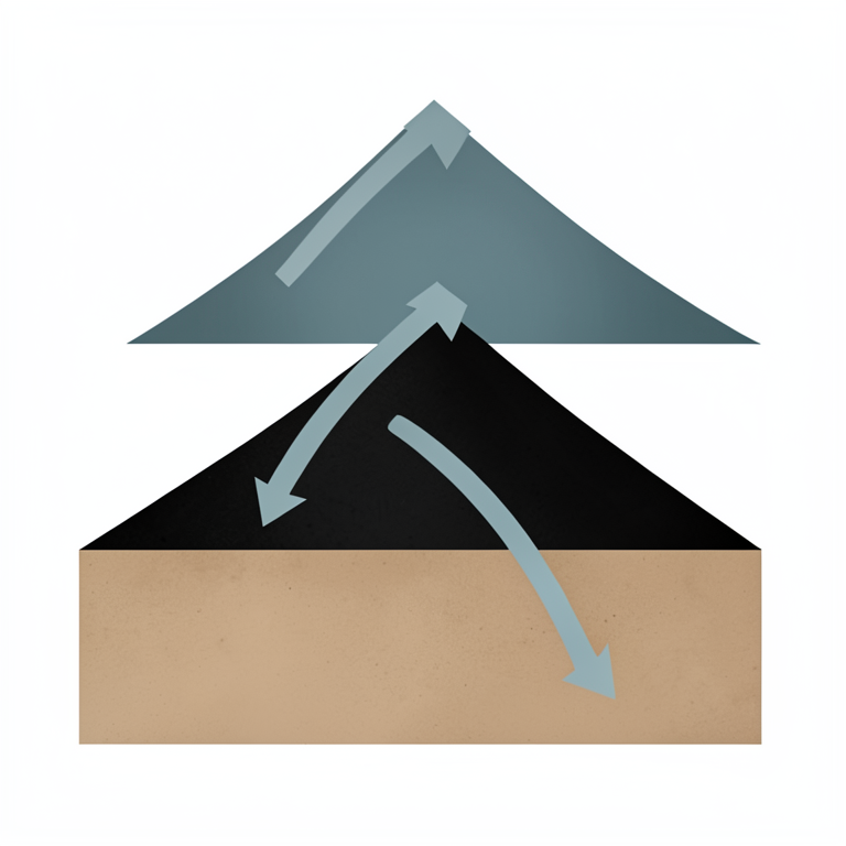
Elevation-Based Soil Fertility Trends
AI-generated conceptual illustration (volcanic soil profiles on a mountain slope in the Javanese Highlands). It explains the idea and does not show study data.
View source evidence ↗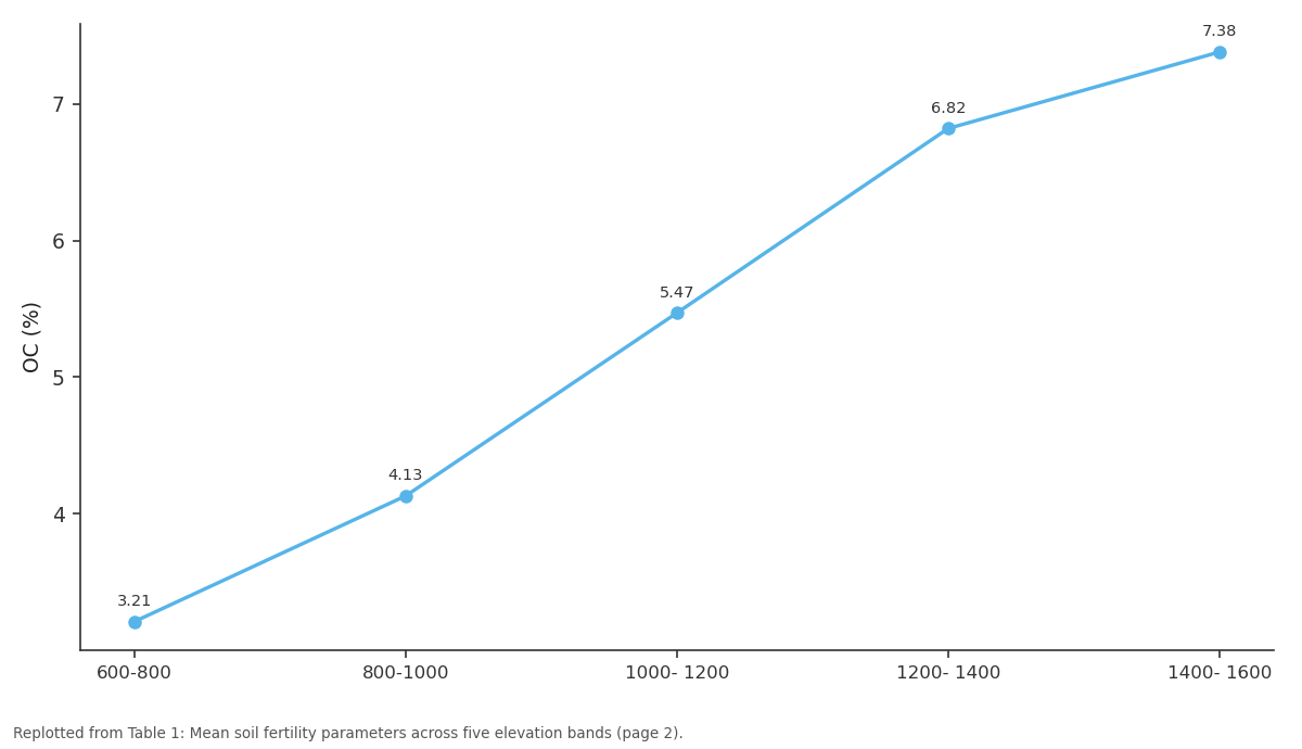
OC (%): 600-800 vs 800-1000 vs 1000- 1200 vs 1200- 1400 vs 1400- 1600
Replotted from Table 1 (page 2) of the original paper. Every bar is the paper's own table value.
View source evidence ↗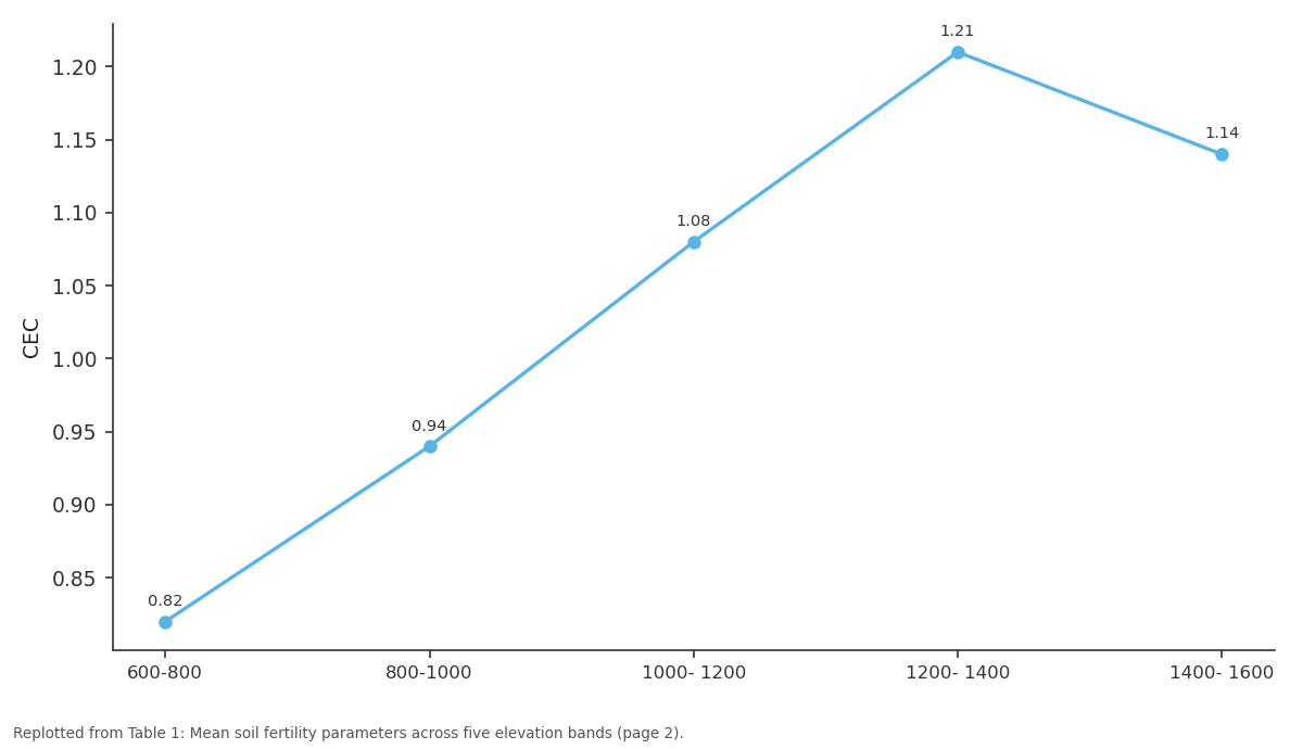
K (cmol): 600-800 vs 800-1000 vs 1000- 1200 vs 1200- 1400 vs 1400- 1600
Replotted from Table 1 (page 2) of the original paper. Every bar is the paper's own table value.
View source evidence ↗Figures & tables
From the original paper Table 2
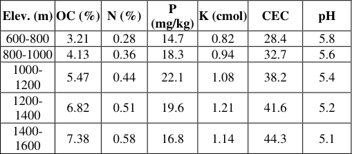 Table 1
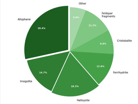 Figure 1
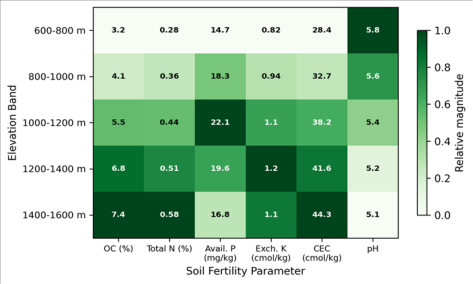 Figure 2
Introduction
Approximately 10% of the global population lives within 100 km of an active volcano, and for many of these communities the surrounding volcanic soils form the foundation of food production [1] . In Java, Indonesia, where population density exceeds 1,100 people per km², volcanic andisols support some of the most intensive smallholder agriculture found anywhere in the tropics [2] . These soils owe their generally high fertility to rapid mineral weathering that releases base cations, combined with organic matter accumulation under cool highland conditions. But the same mineralogical properties-particularly allophane and imogolite dominance-create well-known challenges, most notably the strong fixation of applied phosphorus [3] . Earlier research on Javanese volcanic soils focused primarily on lowland zones below 600 m, where paddy rice systems predominate [4] . Tan [5] characterised andisol mineralogy from several Indonesian volcanoes but didn't link these properties directly to measured crop yields. Van Ranst et al. [6] examined the relationship between allophane content and phosphorus retention in East African volcanic soils, but conditions on Java differ in rainfall intensity and cropping systems. Shoji et al. [8] provided the foundational classification of volcanic ash soils globally. Subsequent work by Parfitt [9] detailed anion retention mechanisms by allophane. The highland zone between 600 and 1,600 m on Java's slopes hosts rice terraces, rainfed maize, and commercial vegetables-each responding differently to soil chemistry [7] . This research set out to characterise soil fertility across five elevation bands and relate measured chemical properties to crop yield records from the same plots [10] .
Study Area Description
The research area covered the western and northern slopes of Mount Merapi and eastern flanks of Mount Merbabu in Central Java Province. The sampling zone stretched from 7°24'S to 7°38'S and 110°20'E to 110°32'E, spanning 600 to 1,600 m elevation. Parent material consisted of Holocene pyroclastic deposits-primarily andesitic ash and lapillioverlying Pleistocene lahar sequences [11] . Land use included irrigated rice terraces at lower elevations, rainfed maize and cassava in the mid-zone, and intensive vegetable cultivation above 1,200 m.
Climatic and Environmental Conditions
Mean annual rainfall ranged from 2,340 mm at 600 m to 3,180 mm at 1,600 m. Mean annual temperature decreased from 24.6°C to 17.8°C following a lapse rate of 0.68°C per 100 m [12] . Relative humidity remained above 78% across all bands during sampling (June 2022 to March 2023). These conditions favour rapid organic matter accumulation but also drive strong leaching of base cations.
Material and Methods Material
The research was based at the Department of Geography, Faculty of Mountain and Polar Studies, Kerman, Iran, with fieldwork in Central Java. A total of 78 composite soil samples were collected from cultivated plots across five elevation bands. Each composite comprised five subsamples from the top 0-30 cm using a stainless-steel auger, bulked and homogenised in the field. Samples were air-dried, sieved through 2 mm mesh, and stored in sealed polyethylene bags. Crop yield data were obtained from the Magelang and Boyolali district agricultural extension services for 2022-2023 [13] .
Methods
Organic carbon was determined by Walkley-Black wet oxidation. Total nitrogen by micro-Kjeldahl digestion. Available phosphorus by the Bray-1 method. Exchangeable potassium was extracted with 1M ammonium acetate at pH 7.0 and measured by flame photometry. CEC was determined by ammonium acetate at pH 7.0. Soil pH was measured in 1:2.5 soil-to-water suspension. Allophane content was estimated by acid oxalate extraction [14] . Mineralogy was confirmed by XRD on oriented clay mounts. Statistical analysis used Pearson correlation and stepwise multiple regression in SPSS version 28. Allophane dominated at 28.4%, followed by halloysite (18.3%) and imogolite (14.7%). Ferrihydrite (12.6%) was more abundant at lower elevations where oxidising conditions prevailed. Maize yields showed the strongest single-parameter correlation with available phosphorus (r² = 0.71). Rice paddy productivity was best explained by CEC and exchangeable potassium (adjusted r² = 0.68). Vegetable yields responded mainly to organic carbon and total nitrogen [15] . The heatmap reveals contrasting vertical trends: organic carbon, nitrogen, and CEC intensify with altitude, while pH and available phosphorus follow different trajectories, reflecting competing effects of organic matter accumulation and allophane-driven phosphorus fixation.
Results
Results
Discussion
The fertility patterns observed are broadly consistent with established models of andisol development on active volcanic slopes. Rising organic carbon and CEC with elevation match findings of Shoji et al. [8] and Dahlgren et al. [16] , who attributed these trends to slower microbial decomposition and increasing allophane content. The strong positive correlation between allophane and CEC (r = 0.87, p < 0.01) supports this interpretation.
The phosphorus peak at 1,000-1,200 m and subsequent decline at higher elevations deserves attention. Below this threshold, availability appears limited by lower weathering inputs. Above it, stronger allophanic fixation renders applied phosphorus less accessible to plant roots [17] . This non-linear behaviour complicates blanket fertiliser recommendations. Farmers above 1,200 m may benefit from targeted phosphorus management-banding rather than broadcasting, or organic amendments that complex aluminium and reduce fixation sites. The finding that maize yields were most tightly linked to available phosphorus aligns with observations from similar volcanic soils in Central America and East Africa [6] . Rice paddy yields appeared less phosphorus-dependent, likely because periodic flooding mobilises iron-bound phosphorus through reductive dissolution. For paddy systems, potassium supply and CEC emerged as more direct constraints, consistent with reports from volcanic rice soils in the Philippines [18] .
Conclusion
This research characterised volcanic soil fertility across five elevation bands in the central Javanese highlands. Organic carbon, total nitrogen, and CEC all increased with elevation, while available phosphorus showed a mid-elevation peak before declining due to intensified allophanic fixation. Phosphorus availability was the strongest single predictor of maize yield, while rice paddy output depended more on CEC and exchangeable potassium. These results carry direct implications for highland soil management. Farmers above 1,200 m should prioritise phosphorus placement techniques and organic amendments to counter fixation, rather than increasing broadcast rates. The data also highlight the need to treat highland volcanic soils as an elevation-specific mosaic rather than a uniform category. Future research should track these soil-yield relationships over multiple seasons and test whether longterm organic matter management can reduce phosphorus fixation capacity in upper elevation bands [19] .
Acknowledgement
Acknowledgements Funding SourcesThis research was supported by departmental research funding with no external commercial sponsorship. Institutional SupportThe authors acknowledge the Department of Geography, Faculty of Mountain and Polar Studies, Kerman, Iran, for analytical facilities. Contributions Not Qualifying for AuthorshipLocal agricultural extension officers in Magelang and Boyolali districts assisted with yield data compilation.
Figures and tables from the paper
| Crop | Best predictor(s) | r² | p-value | n |
|---|---|---|---|---|
| Maize | Available P | 0.71 | <0.01 | 28 |
| Rice paddy | CEC + Exch. K | 0.68 | <0.01 | 22 |
| Vegetables | OC + Total N | 0.59 | <0.01 | 28 |
Table text extracted from the original PDF; superscript letters are shown inline. The original table image is below.
View original table image
| Elev. (m) | OC (%) | N (%) | P (mg/kg) | K (cmol) | CEC | pH |
|---|---|---|---|---|---|---|
| 600-800 | 3.21 | 0.28 | 14.7 | 0.82 | 28.4 | 5.8 |
| 800-1000 | 4.13 | 0.36 | 18.3 | 0.94 | 32.7 | 5.6 |
| 1000- 1200 | 5.47 | 0.44 | 22.1 | 1.08 | 38.2 | 5.4 |
| 1200- 1400 | 6.82 | 0.51 | 19.6 | 1.21 | 41.6 | 5.2 |
| 1400- 1600 | 7.38 | 0.58 | 16.8 | 1.14 | 44.3 | 5.1 |
Table text extracted from the original PDF; superscript letters are shown inline. The original table image is below.
View original table image
References
19 in the original paper- Small C, Naumann T. The global distribution of human population and recent volcanism. Environ Hazards. 2001;3(3):93-109.
- Lavigne F, De Coster B, Juvin N, Flohic F, Gaillard JC, Texier P. People's behaviour in the face of volcanic hazards. J Volcanol Geotherm Res. 2008;172(3-4):273287.
- Harsh JB, Chorover J, Nizeyimana E. Allophane and imogolite. In: Dixon JB, Schulze DG, editors. Soil Mineralogy with Environmental Applications. Madison: SSSA; 2002. p. 291-322.
- Sukristiyonubowo R, Mulyadi M, Wigena P, Kasno A. Soil fertility and rice productivity on volcanic soils of West Java. Indones J Agric Sci. 2011;12(2):73-82.
- Tan KH. Andosols. New York: Van Nostrand Reinhold; 1984.
- Van Ranst E, Shamshuddin J, Baert G, Dzwowa PK. Charge characteristics in relation to free iron and organic matter. Geoderma. 2008;144(1-2):241-253.
- Whitten T, Soeriaatmadja RE, Afiff SA. The Ecology of Java and Bali. Oxford: Oxford University Press; 1996.
- Shoji S, Nanzyo M, Dahlgren RA. Volcanic Ash Soils: Genesis, Properties and Utilization. Amsterdam: Elsevier; 1993.
- Parfitt RL. Allophane in New Zealand: a review. Aust J Soil Res. 1990;28(3):343-360.
- Nanzyo M. Unique properties of volcanic ash soils. Glob Environ Res. 2002;6(2):99-112.
- Newhall CG, Bronto S, Alloway B, Banks NG, Bahar I, del Marmol MA. 10,000 years of explosive eruptions of Merapi Volcano. J Volcanol Geotherm Res. 2000;100(1-4):9-50.
- Aldrian E, Susanto RD. Identification of three dominant rainfall regions within Indonesia. Int J Climatol. 2003;23(12):1435-1452.
- BPS-Statistics Indonesia. Magelang Regency in Figures. Magelang: BPS Kabupaten Magelang; 2023.
- Blakemore LC, Searle PL, Daly BK. Methods for chemical analysis of soils. NZ Soil Bureau Sci Rep No. 80; 1987.
- Buurman P, Peterse F, Almendros Martin G. Soil organic matter chemistry in allophanic soils. Geoderma. 2007;137(3-4):401-409.
- Dahlgren RA, Saigusa M, Ugolini FC. The nature, properties and management of volcanic soils. Adv Agron. 2004;82:113-182.
- Matus F, Amigo X, Kristiansen SM. Aluminium stabilization controls organic carbon levels in Chilean volcanic soils. Geoderma. 2006;132(1-2):158-168.
- Navarrete IA, Tsutsuki K. Land-use impact on soil carbon and nitrogen in a degraded volcanic soil in Leyte. Soil Sci Plant Nutr. 2008;54(3):321-331.
- Takahashi T, Dahlgren RA. Nature, properties and function of aluminium-humus complexes in volcanic soils. Geoderma. 2016;263:110-121.