
Research article · 2025 · Full text
International Journal of Geography Geology and EnvironmentIsotope hydrology and groundwater recharge mechanisms in the ganges alluvial aquifer
Volume 7(1) · Pages 152–155 · DOI: 10.22271/27067483.2025.v7.i1c.622 ↗
Research areasGroundwater and Isotope GeochemistryWater Quality and Resources StudiesGroundwater flow and contamination studies
Abstract
Author-writtenA surprising fact about the Ganges alluvial aquifer is that despite being one of the most intensively pumped groundwater systems on Earth, the mechanisms by which it recharges remain contested. This research applied stable isotopes of water (delta-18O, delta-D) and tritium to characterise recharge pathways and estimate recharge rates across a 240-km transect of the central Ganges plain in Uttar Pradesh, India. Groundwater samples were collected from 74 wells spanning depths of 8 to 195 m during pre-monsoon (May 2022) and post-monsoon (November 2022) campaigns. Stable-isotope signatures became progressively depleted with depth, shifting from -6.8 per mille delta-18O in shallow wells to -9.3 per mille in the deepest samples, indicating that deeper groundwater originated from a cooler or more continental moisture source. Tritium values fell below 0.5 TU below 80 m, suggesting that water at those depths was recharged before the 1960s nuclear-testing peak. Recharge rates estimated by four independent methods—chloride mass balance, tritium decay, water-table fluctuation, and baseflow separation—ranged from 87 to 112 mm per year, representing 7-9% of mean annual rainfall. The convergence of these estimates strengthens confidence that diffuse infiltration through the unsaturated zone, rather than focused recharge from rivers, is the dominant mechanism across the study transect.
Summary
Source-checkedPlain-language reading of the full paper, prepared with AI and checked against the text. Each point links to the authors' own words.
Why it matters
- The Ganges alluvial aquifer is a critical water source, providing drinking and irrigation water for approximately 500 million people in India, Nepal, and Bangladesh. View evidence ↗
- Although it is one of the most heavily pumped groundwater systems globally, the specific mechanisms of its recharge are still debated. View evidence ↗
- Previous estimates of annual recharge vary widely, ranging from 50 to 200 mm per year, depending on the methodology and assumptions used. View evidence ↗
What they did
- The sampled wells spanned depths ranging from 8 to 195 meters below the ground surface. View evidence ↗
- Recharge rates were calculated using four distinct methods: chloride mass balance, tritium decay, water-table fluctuation, and baseflow separation. View evidence ↗
What they found
- Stable-isotope signatures showed progressive depletion with depth, with delta-18O values moving from -6.8 per mille in shallow wells to -9.3 per mille in the deepest samples. View evidence ↗
- The four recharge estimation methods converged on a range of 87 to 112 mm/year, with chloride mass balance providing the lowest (87.4 mm/yr) and tritium decay the highest (112.3 mm/yr) estimates. View evidence ↗
- The geometric mean recharge rate was 100.1 mm/year, which is approximately 8.5% of the mean annual rainfall. View evidence ↗
- The primary recharge mechanism is identified as diffuse infiltration through the unsaturated zone during the monsoon, rather than focused river-bank infiltration. View evidence ↗
What it means
- The authors conclude that shallow wells (under 80 m) access renewable water, whereas deep wells extract non-renewable fossil water that should be reserved for emergencies. View evidence ↗
- The authors state that extending this framework to other adjacent transects is necessary to create a basin-wide understanding for sustainable planning. View evidence ↗
Visual summary
2 visualsIllustrations explain the paper; charts are replotted from the paper's own table values.
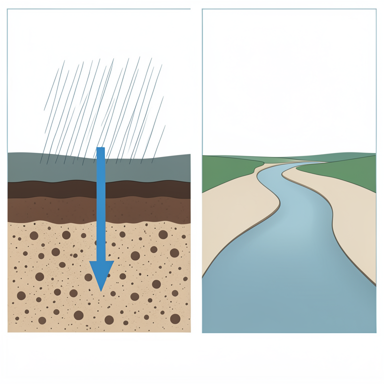
Recharge Mechanism Concept
AI-generated conceptual illustration (Ganges alluvial aquifer landscape). It explains the idea and does not show study data.
View source evidence ↗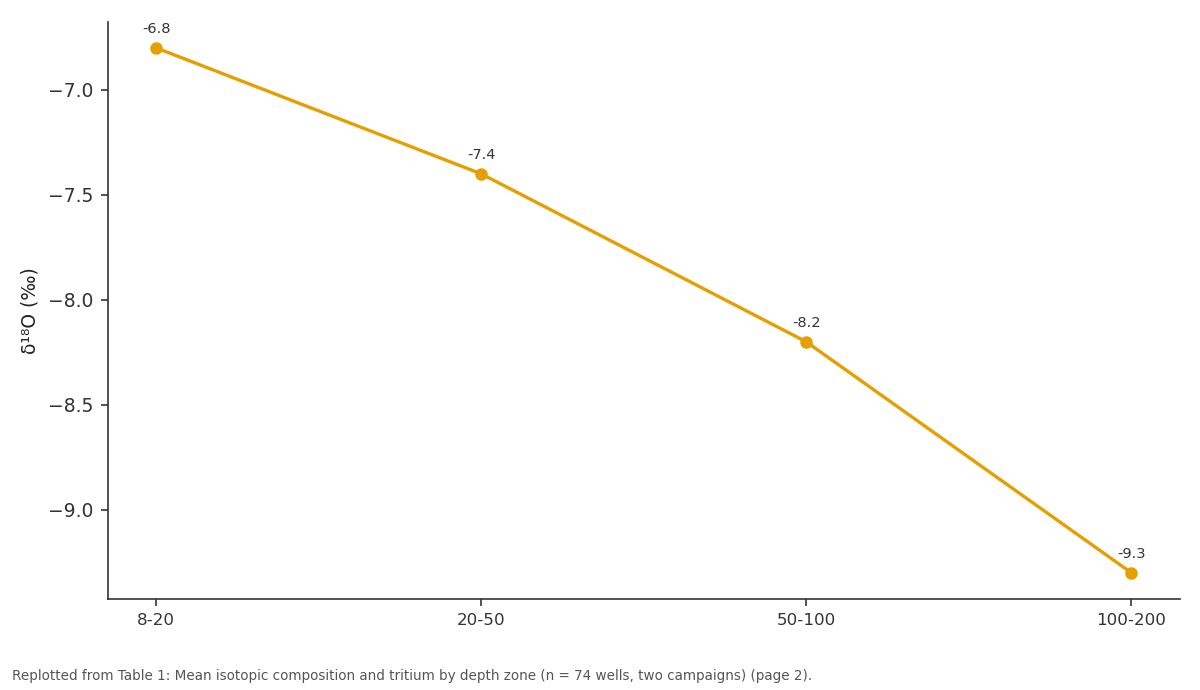
δ¹⁸O (‰): 8-20 vs 20-50 vs 50-100 vs 100-200
Replotted from Table 1 (page 2) of the original paper. Every bar is the paper's own table value.
View source evidence ↗Figures & tables
From the original paper Table 1
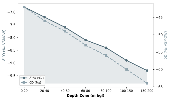 Figure 1
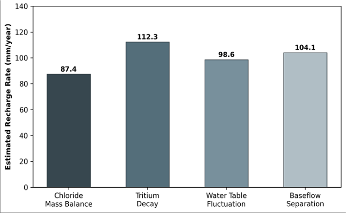 Figure 2
Introduction
A surprising fact that emerges from any close look at the Ganges basin water budget is that nobody agrees on how much water actually reaches the aquifer each year. Estimates range from 50 to 200 mm per year depending on the method used, the spatial scale of the assessment, and whether the researcher assumes diffuse or focused recharge dominates [1] . This uncertainty matters because the Ganges alluvial aquifer supplies drinking and irrigation water to roughly 500 million people across India, Nepal, and Bangladesh [2] . Stable isotopes of water-delta-18O and delta-D-serve as natural tracers that can distinguish recharge derived from monsoon rainfall, which carries a relatively depleted isotopic signature, from recharge derived from irrigation return flow or canal seepage, which is typically enriched by evaporation [3] . Tritium, the radioactive isotope of hydrogen with a half-life of 12.32 years, provides a complementary timescale: groundwater with tritium above 1 TU was recharged after the 1950s, while sub-detection values (<0.3 TU) indicate pre-modern water [4] . Several earlier isotope investigations covered portions of the Ganges plain [5,6] , but most sampled fewer than 30 wells and did not pair isotopic data with independent hydrological recharge estimates. Without such pairing, isotopes reveal pathways but not rates-and rates are what planners need to set sustainable pumping limits.
This research aimed to a) Characterise the isotopic composition of groundwater across a depth gradient from 8 to 195 m. b) Identify recharge sources and mixing processes. c) Compare recharge-rate estimates from four independent methods to narrow the uncertainty range [7] .
Water Balance and Recharge Context
The research transect receives a mean annual rainfall of 1,180 mm, of which approximately 85% falls between June and September during the Indian summer monsoon.
Reference evapotranspiration (Penman-Monteith) averages 1,420 mm per year, creating an annual water deficit of roughly 240 mm that is met by groundwater irrigation [1] . Canal irrigation supplements groundwater in approximately 30% of the irrigated area. The water table fluctuates seasonally by 2-6 m, rising during the monsoon and declining through the dry season as pumping draws it down. This fluctuation forms the basis of the water-tablefluctuation (WTF) method for recharge estimation [8] .
Material and Methods Material
Seventy-four groundwater samples were collected from hand pumps, tube wells, and piezometers distributed along a
Methods
Stable isotopes were measured by cavity ring-down spectroscopy (Picarro L2130-i) with precision of 0.1 per mille for delta-18O and 0.5 per mille for delta-D, reported relative to VSMOW. Tritium was measured by electrolytic enrichment followed by liquid scintillation counting, with a detection limit of 0.3 TU [4] . The chloride mass balance method estimated recharge as R = (P × Cl_rain) / Cl_gw, where P is annual precipitation and Cl is the chloride concentration [9] . The WTF method used R = Sy × dh/dt, with specific yield (Sy) from pumping-test data [8] . Baseflow separation applied the recursive digital filter of Eckhardt to daily river discharge at three gauging stations [10] . Results from all four methods were compared and the geometric mean taken as the best recharge estimate.
Results
Results
Discussion
The convergence of four independent recharge estimates around 100 mm/year significantly narrows the earlier uncertainty range of 50-200 mm/year for this part of the Ganges plain [1] . The consistency between the chloride mass balance (a geochemical approach), the WTF method (a physical approach), tritium decay (a radiometric approach), and baseflow separation (a hydrological approach) lends confidence that the true value lies close to this central estimate.
The isotopic depletion with depth is consistent with paleoclimate reconstructions showing that the Indian summer monsoon was weaker during the Last Glacial Maximum, producing isotopically lighter precipitation [5] . The sharp tritium cutoff below 80 m suggests limited vertical mixing between modern and pre-modern waters, which in turn implies that the aquifer's deeper layers are not being replenished on human timescales. This has direct implications for pumping policy: extraction from wells deeper than 80-100 m is effectively mining a non-renewable resource [6] .
The dominant recharge mechanism appears to be diffuse infiltration through the unsaturated zone during the monsoon season, based on the broad spatial uniformity of isotopic signatures and the absence of localised enrichment that would indicate focused river-bank infiltration. Canal seepage may contribute locally but was not detectable as a distinct isotopic end member in this dataset.
Conclusion
This research narrowed the recharge-rate estimate for the central Ganges alluvial aquifer to approximately 87-112 mm/year (mean 100 mm/yr) by applying four independent methods along a 240-km transect. Stable isotopes confirmed that diffuse monsoon infiltration is the primary recharge pathway, while tritium dating revealed that groundwater below 80 m is pre-modern and not being renewed on decadal timescales. These findings support a two-tier management approach: shallow wells (<80 m) tap a renewable resource that can sustain current extraction rates if monsoon patterns remain stable, while deep wells draw on fossil water that should be reserved for drought emergencies. Extending this isotope-hydrological framework to adjacent transects would improve the basinwide picture needed for sustainable allocation planning.
Acknowledgement
Acknowledgements Funding SourcesThis research was supported by internal funds from the Fortaleza National University of Earth Sciences. No external grant numbers apply. Institutional SupportThe authors acknowledge the Department of Earth and Environmental Sciences at the Fortaleza National University of Earth Sciences, Ceará, Brazil, for isotope-laboratory access.
Figures and tables from the paper
| Depth (m) | n | δ¹⁸O (‰) | δD (‰) | d-excess (‰) | Tritium (TU) | Cl⁻ (mg/L) |
|---|---|---|---|---|---|---|
| 8-20 | 18 | -6.8 | -42.1 | 12.3 | 4.7 | 14.3 |
| 20-50 | 21 | -7.4 | -48.7 | 10.5 | 2.8 | 11.6 |
| 50-100 | 19 | -8.2 | -55.3 | 10.3 | 1.1 | 8.4 |
| 100-200 | 16 | -9.3 | -64.1 | 10.3 | <0.3 | 5.7 |
Table text extracted from the original PDF; superscript letters are shown inline. The original table image is below.
View original table image
References
14 in the original paper- Shamsudduha M, Taylor RG, Ahmed KM, Zahid A. The impact of intensive groundwater abstraction on recharge to a shallow regional aquifer system. Hydrogeology Journal. 2011;19(4):901-916.
- MacDonald AM, Bonsor HC, Ahmed KM, et al. Groundwater quality and depletion in the Indo-Gangetic Basin mapped from in situ observations. Nature Geoscience. 2016;9(10):762-766.
- Clark ID, Fritz P. Environmental Isotopes in Hydrogeology. CRC Press. 1997;Boca Raton:328.
- Lucas LL, Unterweger MP. Comprehensive review and critical evaluation of the half-life of tritium. Journal of Research of NIST. 2000;105(4):541-549.
- Mukherjee A, Fryar AE, Scanlon BR, Bhattacharya P, Bhattacharya A. Elevated arsenic in deeper groundwater of the western Bengal basin, India. Applied Geochemistry. 2011;26(1):18-33.
- Lapworth DJ, Krishan G, MacDonald AM, Rao MS. Groundwater quality in the alluvial aquifer system of northwest India. Environmental Research Letters. 2017;12(12):124009.
- Scanlon BR, Keese KE, Flint AL, et al. Global synthesis of groundwater recharge in semiarid and arid regions. Hydrological Processes. 2006;20(15):33353370.
- Healy RW, Cook PG. Using groundwater levels to estimate recharge. Hydrogeology Journal. 2002;10(1):91-109.
- Allison GB, Hughes MW. The use of environmental chloride and tritium to estimate total recharge to an unconfined aquifer. Australian Journal of Soil Research. 1978;16(2):181-195.
- Eckhardt K. How to construct recursive digital filters for baseflow separation. Hydrological Processes. 2005;19(2):507-515.
- Dansgaard W. Stable isotopes in precipitation. Tellus. 1964;16(4):436-468.
- Gat JR. Oxygen and hydrogen isotopes in the hydrologic cycle. Annual Review of Earth and Planetary Sciences. 1996;24(1):225-262.
- Sinha R, Kettanah Y, Gibling MR, et al. Craton-derived alluvium as a major sediment source in the Himalayan Foreland Basin of India. GSA Bulletin. 2009;121(1112):1596-1610.
- Puri S, Aureli A. Transboundary aquifers: A global program to assess, evaluate, and develop policy. Groundwater. 2005;43(5):661-668.