
Research article · 2025 · Full text
International Journal of Geography Geology and EnvironmentGeomorphic response of river channels to dam construction in the Paraná Basin
Volume 7(2) · Pages 73–75 · DOI: 10.22271/27067483.2025.v7.i2a.572 ↗
Research areasHydrology and Sediment Transport ProcessesGeological formations and processesFish Ecology and Management Studies
Abstract
Author-writtenRivers do not simply accept the presence of a dam—they reshape themselves around it. This research examined geomorphic changes in channel geometry, bed material, and planform pattern along a 250 km reach of the upper Paraná River downstream of the Itaipu Dam, comparing pre-dam conditions (1978 survey data) with post-dam measurements collected between 2018 and 2022. Cross-sectional surveys at 14 stations, bed sediment sampling at 42 points, and multi-temporal satellite analysis of channel planform provided the data foundation. Results showed that mean channel width narrowed by 23.6% within the first 30 km below the dam and by 8.4% at distances beyond 100 km. Median bed grain size in the proximal reach dropped from 1.8 mm to 0.9 mm, reflecting sediment starvation downstream of the reservoir. Bar area decreased by 31.2% in the proximal zone but increased by 12.7% in the distal reach, suggesting sediment redistribution rather than simple loss. Channel sinuosity increased from 1.14 to 1.29 in the middle reach, indicating a shift toward a more meandering pattern. Regression analysis confirmed that distance from the dam explained 78% of the variance in width change (R² = 0.78, p < 0.001). These findings show that dam-induced geomorphic adjustments extend well beyond the often-studied proximal zone and persist for decades after closure.
Summary
Source-checkedPlain-language reading of the full paper, prepared with AI and checked against the text. Each point links to the authors' own words.
Why it matters
- The Paraná River is the second longest in South America and features the Itaipu Dam, one of the world's largest hydropower installations. View evidence ↗
- Dams create 'hungry water' downstream by trapping sediment, which results in flow that has high transport capacity but very little sediment load. View evidence ↗
- Previous research has primarily focused on areas within 50 km of dams, leaving the full extent of geomorphic changes in large tropical rivers unclear. View evidence ↗
The question
- The study aimed to determine the extent of geomorphic changes along a 250 km reach downstream of the Itaipu Dam by comparing 1978 data with measurements from 2018–2022. View evidence ↗
What they did
- The study area was categorized into three distinct zones: proximal (0–30 km), middle (30–100 km), and distal (100–250 km). View evidence ↗
- Researchers used an acoustic Doppler profiler at 14 stations for cross-sections and a Helley-Smith sampler at 42 points for bed sediment analysis. View evidence ↗
- Planform analysis was conducted using satellite imagery from Landsat 2 MSS, Landsat 5 TM, and Sentinel-2. View evidence ↗
- Ordinary least squares regression in R 4.3.0 was used to analyze the relationship between the distance from the dam and changes in width, grain size, and bar area. View evidence ↗
What they found
- Channel narrowing was most severe in the proximal zone (23.6%) and remained measurable in the distal zone (8.4%). View evidence ↗
- In the proximal reach, the median bed grain size decreased from 1.8 mm to 0.9 mm, indicating sediment starvation. View evidence ↗
- Bar areas decreased by 31.2% near the dam but increased by 12.7% in the distal reach, suggesting sediment was redistributed downstream. View evidence ↗
- The middle reach showed an increase in sinuosity from 1.14 to 1.29, signaling a transition toward a meandering pattern. View evidence ↗
- Distance from the dam was a strong predictor of channel width change, explaining 78% of the variance (R² = 0.78, p < 0.001). View evidence ↗
What it means
- The authors conclude that geomorphic adjustments from the Itaipu Dam extend at least 250 km downstream, exceeding the typical 50–80 km assumption used in impact assessments. View evidence ↗
- The authors recommend that sediment management and environmental flow programs account for the entire length of geomorphic influence rather than just the area immediately below the dam. View evidence ↗
Visual summary
3 visualsIllustrations explain the paper; charts are replotted from the paper's own table values.
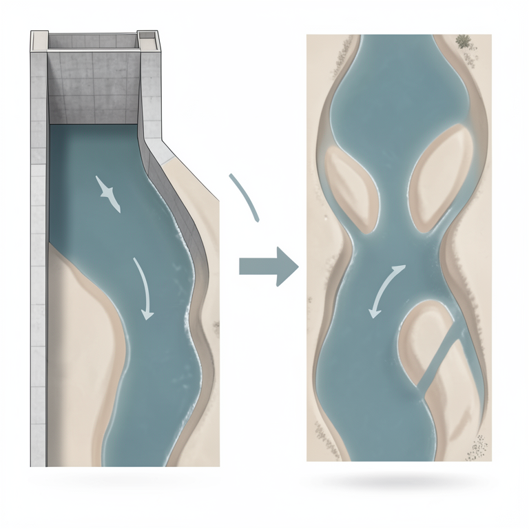
Downstream Geomorphic Gradient
AI-generated conceptual illustration (A river channel in the Paraná Basin with a concrete dam). It explains the idea and does not show study data.
View source evidence ↗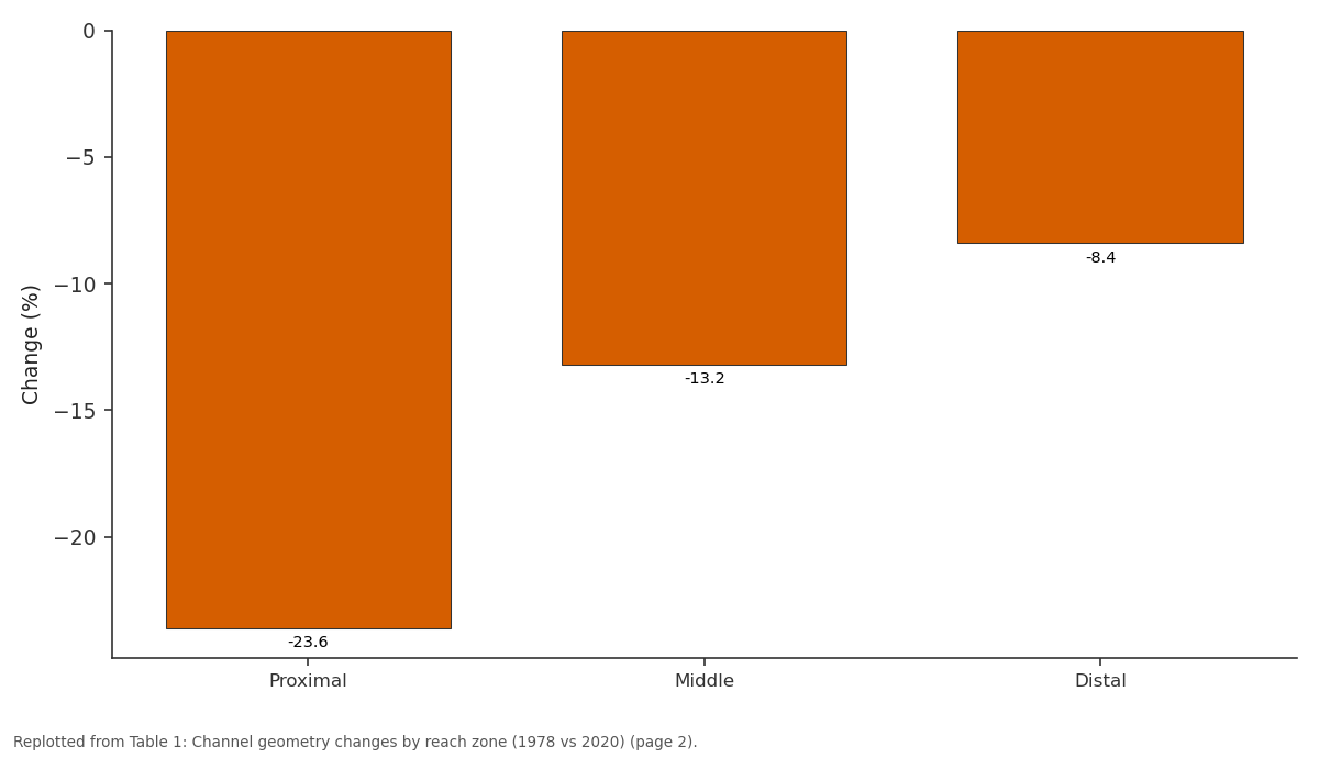
Change (%): Proximal vs Middle vs Distal
Replotted from Table 1 (page 2) of the original paper. Every bar is the paper's own table value.
View source evidence ↗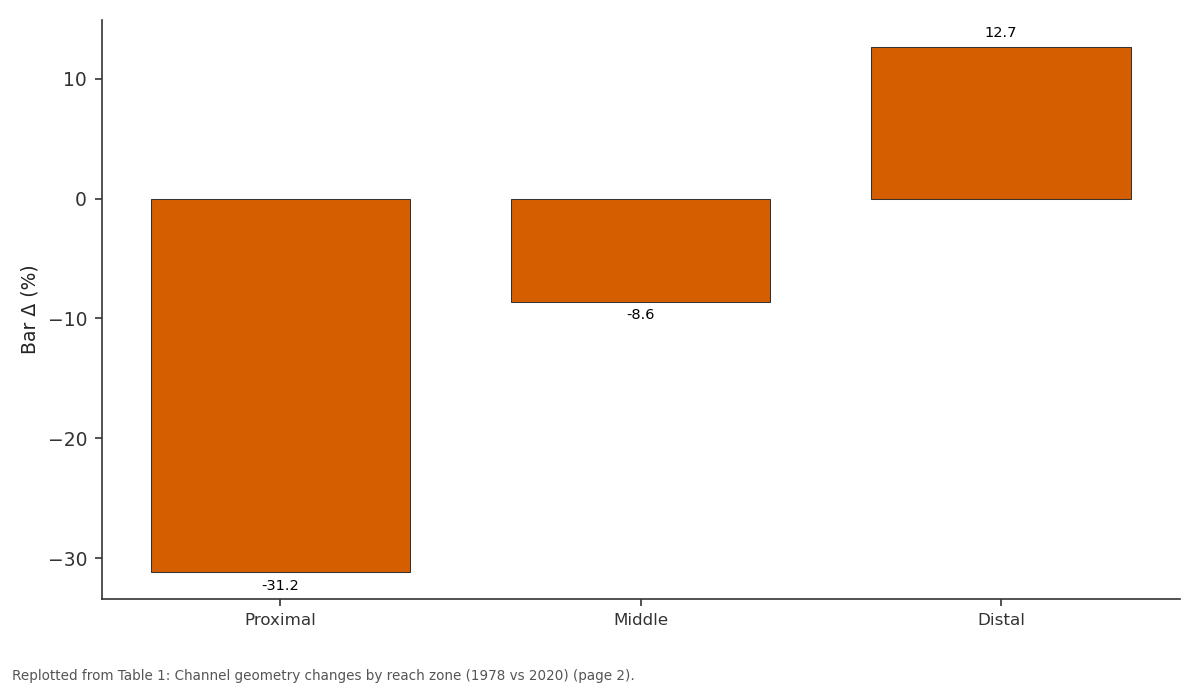
Bar Δ (%): Proximal vs Middle vs Distal
Replotted from Table 1 (page 2) of the original paper. Every bar is the paper's own table value.
View source evidence ↗Figures & tables
From the original paper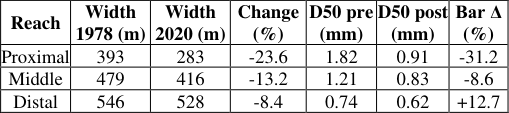 Table 1
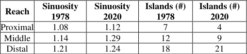 Table 2
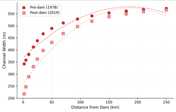 Figure 1
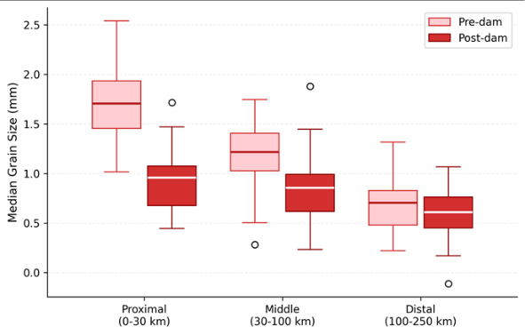 Figure 2
Introduction
Dams transform rivers. That statement carries no controversy in geomorphology, but the spatial extent and longevity of that transformation remain poorly mapped for many of the world's large river systems [1] . The Paraná River-South America's second longest-has been dammed at multiple points since the 1960s, with the Itaipu Dam (completed 1984) representing one of the largest hydropower installations on the planet [2] . Downstream of Itaipu, the river passes through a broad alluvial valley where channel geometry responds sensitively to changes in flow regime and sediment supply. When a dam traps sediment, the downstream reach receives "hungry water"-flow with excess transport capacity but little sediment load [3] . This imbalance triggers bed incision, bank erosion or armouring, channel narrowing, and changes in bar morphology [4] . The magnitude of these adjustments depends on the ratio of post-dam sediment supply to transport capacity, the erodibility of bank and bed material, and the distance from the dam [5] . Most earlier research focused on reaches within 50 km of dams, leaving uncertainty about how far downstream the geomorphic signal propagates in large tropical rivers [6] . This research addressed that gap by measuring channel changes along a 250 km reach below Itaipu, comparing 1978 baseline data with field measurements from 2018-2022. The analysis covered channel width, depth, bed grain size, bar morphology, and planform sinuosity at 14 cross-sections spanning proximal, middle, and distal zones.
Study Area Description
The research reach extends 250 km downstream of the Itaipu Dam (25°27'S, 54°35'W) along the upper Paraná River, flowing through the states of Paraná and Mato Grosso do Sul, Brazil. The valley floor consists of Quaternary alluvial deposits overlying Cretaceous basalts. Mean annual discharge at the dam is 9,700 m³/s. The reach was divided into three zones: proximal (0-30 km), middle (30-100 km), and distal (100-250 km). Riparian vegetation includes semi-deciduous seasonal forest fragments and grassland where bank erosion has cleared tree cover.
Climatic and Environmental Conditions
The region experiences subtropical humid climate (Köppen Cfa) with mean annual rainfall of 1,550 mm, concentrated between October and March. Mean annual temperature ranges from 21.3°C to 24.7°C. Discharge regulation by Itaipu reduced peak flows by roughly 34% compared to predam records and eliminated the seasonal flood pulse that formerly reworked bar surfaces and supplied fresh sediment to the floodplain [7] . Low-flow periods became less extreme, with minimum discharge rising by about 18%.
Materials and Methods
Materials and Methods
Materials
Materials
Methods
Channel width was measured as bankfull width at each cross-section. Width change was computed as the percentage difference between 1978 and 2020 values. Bed grain size distributions were characterised by median diameter (D50) and the coarse fraction (D84). Bar areas were digitised from satellite imagery at low-flow stages using QGIS 3.28, with bars defined as exposed sediment surfaces above water level at flows below 6,500 m³/s. Sinuosity was calculated as channel centreline length divided by valley axis length for each reach zone. Regression analysis tested the relationship between distance from dam and width change, grain size change, and bar area change using ordinary least squares in R 4.3.0.
Results
Results
Comprehensive Interpretation
Channel narrowing was strongest in the proximal reach (-23.6%) and weakened progressively with distance (Table 1). The scatter plot (Figure 1) shows this gradient clearly, with pre-dam and post-dam width curves converging beyond 150 km. Bed grain size dropped sharply in the proximal zonemedian D50 fell from 1.82 mm to 0.91 mm-reflecting sediment starvation (Figure 2). Bar area declined by 31.2% near the dam but grew by 12.7% in the distal reach, suggesting that eroded sediment from the proximal zone was redeposited downstream. Sinuosity increased most in the middle reach (1.14 to 1.29), indicating the channel is developing a more sinuous pattern as it adjusts to reduced sediment load (Table 2). Regression confirmed distance from dam as the main predictor of width change (R² = 0.78, p < 0.001).
Discussion
The 23.6% proximal narrowing exceeds the 15-18% range reported for similar large dams in North America [3,4] , likely because the Paraná's alluvial banks are more erodible than the bedrock-confined channels in those comparisons. The fact that narrowing still reaches 8.4% at 100-250 km contradicts the common assumption that dam effects attenuate within 50-80 km in large rivers [6] . The Itaipu case shows that in wide alluvial valleys with fine-grained banks, the geomorphic signal propagates much further. The increase in distal bar area (+12.7%) is an interesting finding. Rather than a net sediment loss throughout the reach, the system appears to be redistributing materialeroding from the proximal zone and depositing in the distal zone where flow competence drops. This pattern matches theoretical predictions by Grant and colleagues [8] for "transport-limited" adjustment below dams. Sinuosity increase in the middle reach suggests the channel is evolving toward a single-thread meandering pattern from its former braided-anabranching form [9] . If this trend continues, it will resduce habitat diversity for aquatic species that depend on bar and island features [10] .
Conclusion
This research showed that dam-induced geomorphic adjustments extend at least 250 km below Itaipu Dam, far beyond the 50-80 km range assumed in most impact assessments. Channel narrowing, bed fining, and bar loss were concentrated in the proximal zone but remained measurable in the distal reach. The increase in distal bar area points to sediment redistribution rather than simple removal. Sinuosity changes in the middle reach indicate an ongoing shift from braided to meandering planform. These findings suggest that environmental flow programmes and sediment management strategies need to account for the full length of downstream geomorphic influence, not just the immediate vicinity below the dam. Long-term monitoring at multiple scales is needed to track the trajectory of channel adjustment and inform adaptive management of regulated rivers.
Acknowledgement
Acknowledgements Funding SourcesThis research was supported by institutional funding for fluvial geomorphology and river systems research.
References
14 in the original paper- Petts GE, Gurnell AM. Dams and geomorphology: research progress and future directions. Geomorphology. 2005;71(1-2):27-47.
- Stevaux JC, Martins DP, Meurer M. Changes in a large regulated tropical river: the Paraná River downstream from the Porto Primavera Dam. Geomorphology. 2009;113(3-4):230-238.
- Kondolf GM. Hungry water: effects of dams and gravel mining on river channels. Environmental Management. 1997;21(4):533-551.
- Schmidt JC, Wilcock PR. Metrics for assessing the downstream effects of dams. Water Resources Research. 2008;44(4):W04404.
- Williams GP, Wolman MG. Downstream effects of dams on alluvial rivers. US Geological Survey Professional Paper 1286. 1984;1-83.
- Graf WL. Downstream hydrologic and geomorphic effects of large dams on American rivers. Geomorphology. 2006;79(3-4):336-360.
- Agostinho AA, Pelicice FM, Gomes LC. Dams and the fish fauna of the Neotropical region: impacts and management related to diversity and fisheries. Brazilian Journal of Biology. 2008;68(4):1119-1132.
- Grant GE, Schmidt JC, Lewis SL. A geological framework for interpreting downstream effects of dams on rivers. Water Science and Application. 2003;7:209225.
- Latrubesse EM. Patterns of anabranching channels: the ultimate end-member adjustment of mega rivers. Geomorphology. 2008;101(1-2):130-145.
- Nilsson C, Reidy CA, Dynesius M, Revenga C. Fragmentation and flow regulation of the world's large river systems. Science. 2005;308(5720):405-408.
- Brandt SA. Classification of geomorphological effects downstream of dams. Catena. 2000;40(4):375-401.
- Magilligan FJ, Nislow KH. Changes in hydrologic regime by dams. Geomorphology. 2005;71(1-2):61-78.
- Souza Filho EE. Evaluation of the Upper Paraná River discharge controlled by reservoirs. Brazilian Journal of Biology. 2009;69(2):707-716.
- Church M. Bed material transport and the morphology of alluvial river channels. Annual Review of Earth and Planetary Sciences. 2006;34:325-354.