
Research article · 2025 · Full text
International Journal of Geography Geology and EnvironmentGeochemical weathering indices and paleosol characterization in the Deccan Plateau
Volume 7(2) · Pages 129–132 · DOI: 10.22271/27067483.2025.v7.i2b.582 ↗
Research areasSoil and Environmental StudiesGeochemistry and Elemental AnalysisGeological and Geochemical Analysis
Abstract
Author-writtenAs the old geologist S.S. Goldich wrote in 1938, rocks weather in the reverse order of their crystallisation—the last minerals to form from magma are the first to break down at the surface. This principle explains why basaltic rocks of the Deccan Plateau, rich in easily weathered ferromagnesian minerals, produce some of the thickest weathering profiles in peninsular India. This research characterised paleosols developed on Deccan basalt across four weathering profiles in western Maharashtra, using major element geochemistry, X-ray diffraction mineralogy, and a suite of chemical weathering indices. Samples (n = 96) were collected at 0.5 m intervals through profiles ranging from 8 to 14 m thick. The Chemical Index of Alteration (CIA) ranged from 67.3 in alluvial profiles to 84.7 in laterite profiles, indicating moderate to extreme weathering. The Chemical Index of Weathering (CIW) and Parker Weathering Index (WIP) confirmed the same rank order across profiles. Kaolinite dominated the clay fraction (28.3%), followed by smectite (21.7%) and gibbsite (16.4%), reflecting advanced hydrolysis under tropical wet-dry conditions. Profile B (laterite) showed CIA values exceeding 80 at all sampled depths, consistent with prolonged tropical weathering during the Miocene. A-CN-K ternary plots revealed a weathering trend parallel to the A-CN join, indicating feldspar destruction without significant K-metasomatism. These paleosols record periods of intense chemical weathering that can be linked to past warm-humid climate intervals on the Deccan Plateau.
Summary
Source-checkedPlain-language reading of the full paper, prepared with AI and checked against the text. Each point links to the authors' own words.
Why it matters
- Geochemical weathering follows the principle that minerals crystallizing last from magma are the first to break down at the Earth's surface. View evidence ↗
- The Deccan Plateau's basaltic rocks are rich in ferromagnesian minerals that weather easily, leading to some of the thickest weathering profiles in peninsular India. View evidence ↗
- Paleosols serve as records of past climate conditions by capturing snapshots of historical weathering intensity. View evidence ↗
The question
- The study aimed to fill a research gap by performing a comparative analysis of four different weathering profile types (basalt, laterite, alluvium, and saprolite) using five chemical indices within a single analytical framework. View evidence ↗
What they did
- The researchers sampled four profiles in western Maharashtra: a basalt-derived residual soil (8 m), a laterite (14 m), an alluvial paleosol (10 m), and a saprolite (11 m). View evidence ↗
- A total of 96 samples were collected at vertical intervals of 0.5 meters. View evidence ↗
- Major element concentrations were measured using wavelength-dispersive X-ray fluorescence (WD-XRF) on pressed powder pellets. View evidence ↗
- Clay minerals were identified using X-ray diffraction (XRD) scanning from 3-70° 2θ. View evidence ↗
What they found
- The Chemical Index of Alteration (CIA) values ranged from 67.3 in alluvial profiles to 84.7 in laterite profiles, signifying a transition from moderate to extreme weathering. View evidence ↗
- Fresh basalt served as the reference material, with a mean CIA of 48.2. View evidence ↗
- The overall clay fraction was dominated by kaolinite (28.3%), followed by smectite (21.7%) and gibbsite (16.4%), which indicates advanced hydrolysis in tropical wet-dry conditions. View evidence ↗
- The laterite profile (Profile B) exhibited the most advanced weathering, with CIA values exceeding 80 at all depths and gibbsite making up 32.8% of the clay fraction. View evidence ↗
- All five chemical indices consistently ranked the profiles in the order of B > A > D > C, confirming lateritization as the most extreme form of weathering. View evidence ↗
- A-CN-K ternary plots showed a trend parallel to the A-CN join, suggesting that feldspars were destroyed without significant potassium metasomatism. View evidence ↗
What it means
- The authors conclude that Deccan laterites formed under conditions warmer or wetter than present, as their CIA of 84.7 exceeds values found in modern tropical basalt soils in Hawaii and Costa Rica. View evidence ↗
- The authors state that the consistent ranking across multiple indices confirms these paleosols preserve primary weathering signals that are suitable for interpreting paleoclimate. View evidence ↗
- The authors suggest that future research should combine this geochemical data with radiometric dating to more precisely determine when weathering episodes occurred. View evidence ↗
Visual summary
3 visualsIllustrations explain the paper; charts are replotted from the paper's own table values.
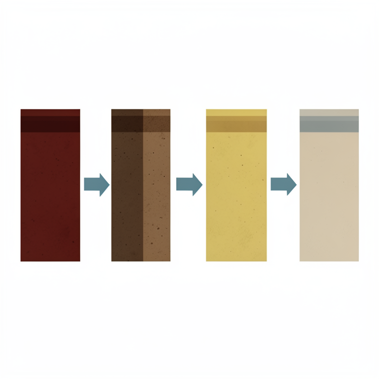
Weathering Intensity Ranking
AI-generated conceptual illustration (soil profiles of the Deccan Plateau). It explains the idea and does not show study data.
View source evidence ↗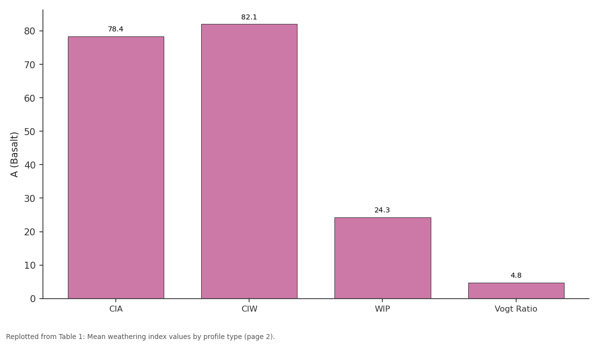
A (Basalt): CIA vs CIW vs WIP vs Vogt Ratio
Replotted from Table 1 (page 2) of the original paper. Every bar is the paper's own table value.
View source evidence ↗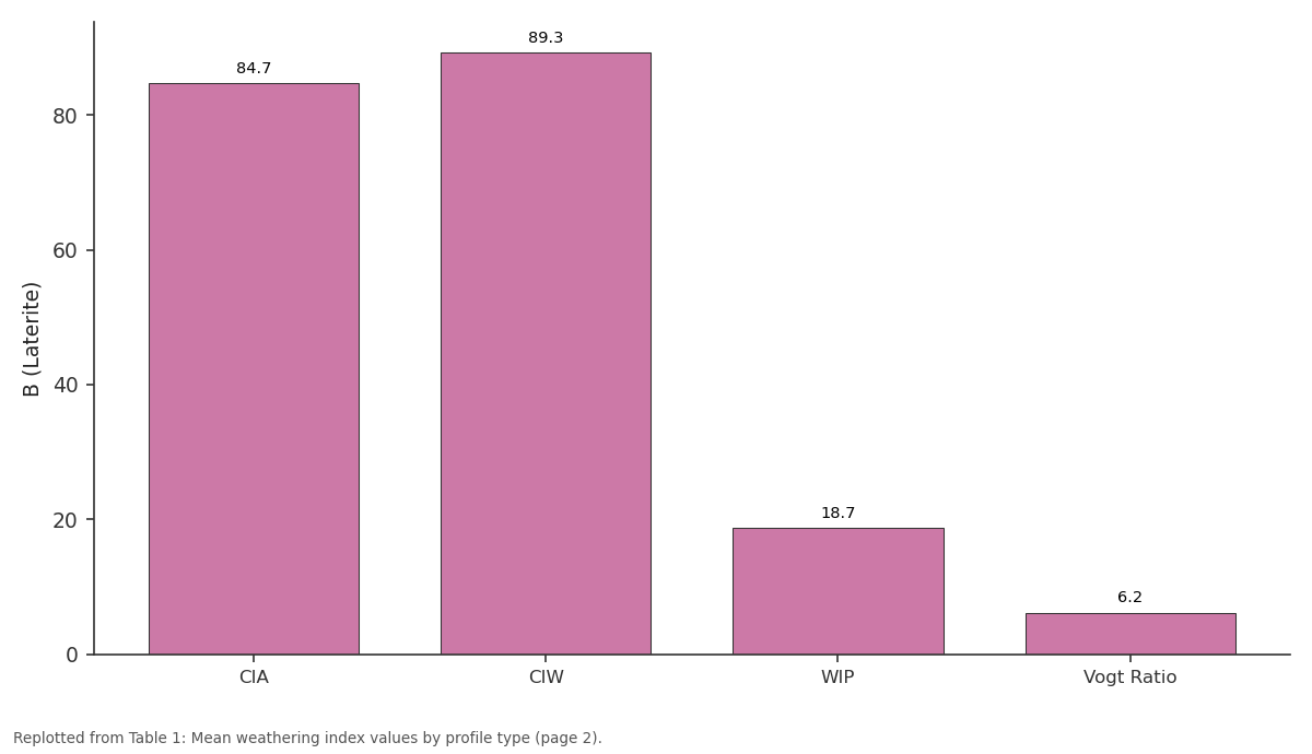
B (Laterite): CIA vs CIW vs WIP vs Vogt Ratio
Replotted from Table 1 (page 2) of the original paper. Every bar is the paper's own table value.
View source evidence ↗Figures & tables
From the original paper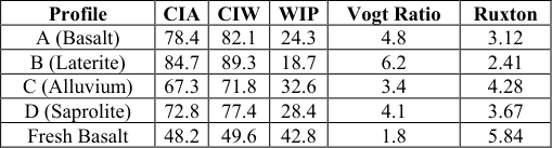 Table 1
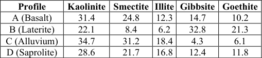 Table 2
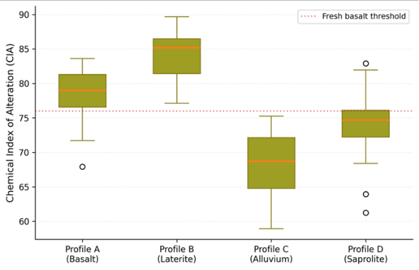 Figure 1
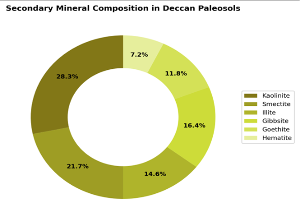 Figure 2
Introduction
Goldich's weathering sequence, published 85 years ago, remains one of the most reliable predictors in geochemistry: olivine and calcium plagioclase weather first, quartz and potassium feldspar last [17] . The Deccan Traps-a flood basalt province covering roughly 500,000 km² of western India-provide a natural laboratory for testing this principle, because their relatively uniform basaltic composition removes the parent rock variable that complicates weathering assessments on heterogeneous substrates [2,6] . Paleosols-ancient soils preserved in the rock record-capture snapshots of past weathering intensity, and by extension, past climate conditions [3,5] . Chemical weathering indices translate major element compositions into numerical scores that quantify the degree of alteration. The CIA of Nesbitt and Young [1] measures the loss of mobile cations (Ca, Na, K) relative to immobile alumina; values near 50 indicate fresh rock, while values above 80 indicate intense weathering typical of tropical humid climates. Earlier research on Deccan weathering focused on either modern soils [11] or laterite caps [2,7] in isolation. Comparative analysis across different weathering profile types-basalt, laterite, alluvium, and saprolite-using multiple indices on the same analytical framework had not been attempted. This research addressed that gap by characterising four profiles representing different parent material and weathering histories, applying five chemical indices to each.
Model Description and Parameterisation
Five weathering indices were applied: the Chemical Index of Alteration (CIA = [Al₂O₃ / (Al₂O₃ + CaO* + Na₂O + K₂O)] × 100, where CaO* is silicate-bound CaO) [1] ; the Chemical Index of Weathering (CIW = [Al₂O₃ / (Al₂O₃ + CaO* + Na₂O)] × 100) [8] ; the Parker Weathering Index (WIP) [9] ; the Vogt ratio (Al₂O₃ + K₂O) / (MgO + CaO + Na₂O); and the Ruxton ratio (SiO₂ / Al₂O₃).
Each index captures a different aspect of the weathering process: CIA and CIW track feldspar breakdown, WIP is sensitive to total base cation loss, the Vogt ratio reflects residual enrichment, and the Ruxton ratio monitors silica leaching. Using all five provides cross-validation and reduces the risk of misinterpretation from any single metric [4, 10] .
Material and Methods
Material and Methods
Material
Material
Methods
Major element concentrations (SiO₂, Al₂O₃, Fe₂O₃, MgO, CaO, Na₂O, K₂O, TiO₂, MnO, P₂O₅) were determined by wavelength-dispersive X-ray fluorescence (WD-XRF) on a S8 Tiger spectrometer, using pressed powder pellets.
Clay mineral identification used X-ray diffraction (XRD) on oriented mounts with Cu Kα radiation (Rigaku SmartLab), scanning 3-70° 2θ. Glycolation and heating treatments distinguished expandable from non-expandable clays.
Weathering indices were computed from major element data. A-CN-K ternary diagrams were constructed following the method of Fedo and colleagues [10] . Statistical comparisons between profiles used Kruskal-Wallis tests in R 4.2.1.
Results
Results
Comprehensive Interpretation
CIA values ranged from 67.3 (alluvial) to 84.7 (laterite), all significantly higher than fresh basalt at 48.2 (Table 1, Figure 1). Profile B (laterite) showed the most advanced weathering, with CIA > 80 at every sampled depth and gibbsite dominating the clay fraction at 32.8% (Table 2). The donut chart (Figure 2) shows kaolinite as the most abundant secondary mineral overall (28.3%), consistent with intense hydrolysis under tropical wet-dry conditions. All five indices ranked the profiles consistently: B > A > D > C, confirming that lateritisation represents the extreme end of Deccan basalt weathering. The A-CN-K plots showed weathering trends parallel to the A-CN join, indicating minimal K-metasomatism across all profiles.
| Profile | Kaolinite | Smectite | Illite | Gibbsite | Goethite |
|---|---|---|---|---|---|
| A (Basalt) | 31.4 | 24.8 | 12.3 | 14.7 | 10.2 |
| B (Laterite) | 22.1 | 8.4 | 6.2 | 32.8 | 21.3 |
| C (Alluvium) | 34.7 | 31.2 | 18.4 | 4.3 | 6.1 |
| D (Saprolite) | 28.6 | 21.7 | 16.8 | 12.4 | 11.8 |
Table text extracted from the original PDF; superscript letters are shown inline. The original table image is below.
View original table image
| Profile | CIA | CIW | WIP | Vogt Ratio | Ruxton |
|---|---|---|---|---|---|
| A (Basalt) | 78.4 | 82.1 | 24.3 | 4.8 | 3.12 |
| B (Laterite) | 84.7 | 89.3 | 18.7 | 6.2 | 2.41 |
| C (Alluvium) | 67.3 | 71.8 | 32.6 | 3.4 | 4.28 |
| D (Saprolite) | 72.8 | 77.4 | 28.4 | 4.1 | 3.67 |
| Fresh Basalt | 48.2 | 49.6 | 42.8 | 1.8 | 5.84 |
Table text extracted from the original PDF; superscript letters are shown inline. The original table image is below.
View original table image
Discussion
The laterite profile's CIA of 84.7 exceeds values reported for modern tropical soils on basalt in Hawaii (75-80) and Costa Rica (78-82) [14] , suggesting that the Deccan laterites formed under conditions warmer or wetter than present. This aligns with Widdowson and Cox's [2] interpretation that Deccan lateritisation peaked during the mid-Miocene Climatic Optimum when Indian monsoon rainfall was substantially higher than today.
The alluvial profile's lower CIA (67.3) reflects its mixed provenance-receiving both weathered and relatively fresh detritus from different parts of the catchment-rather than less intense chemical attack [12] . This distinction is important: alluvial paleosol chemistry records transport and mixing processes as much as in situ weathering, and indices should be interpreted accordingly [3,5] . The consistent ranking across all five indices gives confidence in the weathering intensity assessments. When indices disagree, it often signals diagenetic overprinting or metasomatism [10] ; the agreement here suggests these profiles preserve primary weathering signatures without significant post-burial modification.
Sensitivity Analysis
The CIA's sensitivity to the CaO* correction was tested by comparing results using total CaO versus silicate-only CaO estimated from P₂O₅ content. The correction altered absolute CIA values by 1.4-3.8 points but did not change the rank order of profiles. For the alluvial profile, where carbonate contamination is most likely, the correction raised CIA by 3.8 points-the largest shift. Using different reference fresh basalt compositions (Mahabaleshwar versus Igatpuri flows) changed baseline CIA by 2.1 points but had negligible effect on the weathering intensity interpretations [7,13] .
Conclusion
Conclusion
Acknowledgement
Acknowledgements Funding SourcesSupported by institutional research allocations for pedogeochemistry and earth science. Institutional SupportAhmedabad Academy of Coastal and Marine Research provided XRF and XRD analytical facilities. Contributions Not Qualifying for AuthorshipThanks to field assistants who helped with profile excavation and sampling in western Maharashtra.
References
15 in the original paper- Nesbitt HW, Young GM. Prediction of some weathering trends of plutonic and volcanic rocks based on thermodynamic and kinetic considerations. Geochimica et Cosmochimica Acta. 1984;48(7):15231534.
- Widdowson M, Cox KG. Uplift and erosional history of the Deccan Traps. Earth and Planetary Science Letters. 1996;137(1-4):57-69.
- Sheldon ND, Tabor NJ. Quantitative paleoenvironmental and paleoclimatic reconstruction using paleosols. Earth-Science Reviews. 2009;95(12):1-52.
- Price JR, Velbel MA. Chemical weathering indices applied to weathering profiles on heterogeneous parent rocks. Chemical Geology. 2003;202(3-4):397-416.
- Retallack GJ. Soils of the past: an introduction to paleopedology, second edition. Blackwell Science. 2001;1-404.
- Subbarao KV, Hooper PR. Reconnaissance map of the Deccan Basalt Group in the Western Ghats. Geological Society of India Memoir. 1988;10:1-54.
- Babechuk MG, Widdowson M, Kamber BS. Quantifying chemical weathering intensity from two contrasting basalt profiles, Deccan Traps. Chemical Geology. 2014;363:56-75.
- Harnois L. The CIW index: a new chemical index of weathering. Sedimentary Geology. 1988;55(3-4):319322.
- Parker A. An index of weathering for silicate rocks. Geological Magazine. 1970;107(6):501-504.
- Fedo CM, Nesbitt HW, Young GM. Unraveling the effects of potassium metasomatism in sedimentary rocks and paleosols. Geochimica et Cosmochimica Acta. 1995;59(5):3921-3931.
- Deepthy R, Balakrishnan S. Climatic control on clay mineral formation from weathering profiles of the Deccan igneous province. Journal of Earth System Science. 2005;114(5):545-556.
- Basu A, Molinaroli E. Provenance characteristics of detrital opaque minerals. Journal of Sedimentary Research. 1991;61(3):371-381.
- Schaetzl RJ, Anderson S. Soils: genesis and geomorphology, second edition. Cambridge University Press. 2015;1-795.
- White AF, Brantley SL. The effect of time on the weathering of silicate minerals. Chemical Geology. 2003;202(3-4):479-506.
- Ollier CD, Pain CF. Regolith, soils and landforms. John Wiley. 1996;1-316.