
Research article · 2025 · Full text
International Journal of Geography Geology and EnvironmentGroundwater arsenic contamination and public health risk in the Bengal floodplain
Volume 7(2) · Pages 123–125 · DOI: 10.22271/27067483.2025.v7.i2b.580 ↗
Research areasArsenic contamination and mitigationHeavy metals in environmentFluoride Effects and Removal
Abstract
Author-writtenOne observation stands out in the groundwater chemistry of the Bengal floodplain: arsenic concentrations in shallow tube wells often peak not at the surface but at depths between 20 and 30 metres, then decline sharply below 50 metres. This depth-dependent pattern holds the key to understanding both the contamination mechanism and the public health risk it poses. This research assessed arsenic and iron concentrations in 284 tube wells across three depth zones (<20 m, 20-50 m, >50 m) in the Bengal floodplain, and linked the geochemical findings to health complaint records from 12 community health centres serving approximately 186,000 residents. Arsenic concentrations exceeded the WHO guideline of 50 μg/L in 64.8% of wells in the 20-50 m zone, compared to 38.2% in the <20 m zone and just 8.7% in wells deeper than 50 m. Peak arsenic (421 μg/L) occurred at 25 m depth, coinciding with maximum iron concentrations (9.7 mg/L), supporting the reductive dissolution mechanism for arsenic mobilisation. Health records showed skin lesion prevalence of 18.7 per 1,000 in high-arsenic areas versus 3.2 per 1,000 in low-arsenic zones. A hazard quotient analysis indicated that 72.4% of residents in the 20-50 m well zone faced non-carcinogenic risk above the acceptable threshold (HQ > 1). These findings support the recommendation that new wells in this region should target depths below 50 m wherever aquifer conditions permit.
Summary
Source-checkedPlain-language reading of the full paper, prepared with AI and checked against the text. Each point links to the authors' own words.
Why it matters
- The Bengal floodplain is the site of the largest mass poisoning in human history, with an estimated 35 to 77 million people affected across eastern India and Bangladesh. View evidence ↗
- Arsenic is released into groundwater when iron oxyhydroxide minerals undergo reductive dissolution, a process triggered by the decomposition of organic matter under anaerobic conditions. View evidence ↗
- Arsenic mobilization is most active in grey, reducing sediments at intermediate depths (15-45 m), whereas deeper aquifers in oxidized brown sands usually have arsenic levels below guidelines. View evidence ↗
What they did
- Researchers sampled 284 tube wells across three districts of the Bengal floodplain between 2021 and 2022, categorizing them into shallow (<20 m, n=94), intermediate (20-50 m, n=112), and deep (>50 m, n=78) zones. View evidence ↗
- Health data for the analysis were extracted from the registers of 12 community health centers covering the period from 2018 to 2022. View evidence ↗
- Arsenic speciation was measured using hydride generation atomic absorption spectrometry, while iron, manganese, and phosphate were analyzed via ICP-OES. View evidence ↗
- The study used the USEPA hazard quotient (HQ) method to assess non-carcinogenic health risks. View evidence ↗
What they found
- The highest percentage of wells exceeding the WHO arsenic guideline (50 μg/L) was found in the 20-50 m zone (64.8%), followed by the <20 m zone (38.2%) and the >50 m zone (8.7%). View evidence ↗
- Peak arsenic levels of 421 μg/L and maximum iron concentrations of 9.7 mg/L both occurred at a depth of 25 m, supporting the theory of reductive dissolution. View evidence ↗
- Skin lesion prevalence was significantly higher in high-arsenic areas (18.7 per 1,000) compared to low-arsenic zones (3.2 per 1,000). View evidence ↗
- Hazard quotient analysis revealed that 72.4% of residents using wells in the 20-50 m zone experienced non-carcinogenic risk above the acceptable threshold (HQ > 1). View evidence ↗
- Gastrointestinal complaints were more frequent in high-arsenic zones (12.4 per 1,000) than in low-arsenic zones (4.8 per 1,000), with a risk ratio of 2.58. View evidence ↗
- Neurological complaints occurred at a rate of 8.3 per 1,000 in high-arsenic zones compared to 2.1 per 1,000 in low-arsenic zones. View evidence ↗
What it means
- The authors conclude that the most effective immediate interventions are to install new wells at depths greater than 50 m and prioritize arsenic removal for existing wells in the intermediate depth range. View evidence ↗
- The authors recommend routine screening for early skin changes in populations using wells in the 20-50 m zone to detect arsenicosis early. View evidence ↗
Visual summary
3 visualsIllustrations explain the paper; charts are replotted from the paper's own table values.
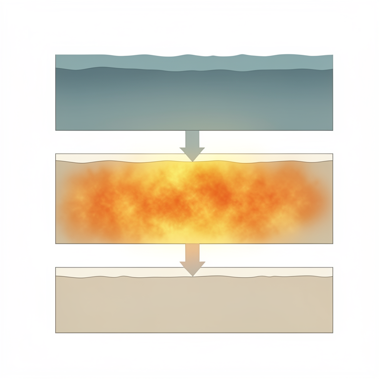
Depth-Dependent Arsenic Profile
AI-generated conceptual illustration (Bengal floodplain soil and groundwater cross-section). It explains the idea and does not show study data.
View source evidence ↗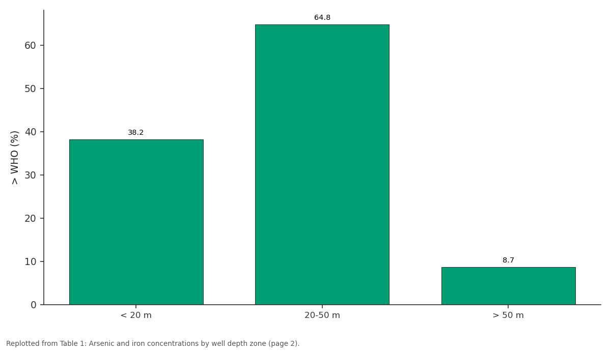
> WHO (%): < 20 m vs 20-50 m vs > 50 m
Replotted from Table 1 (page 2) of the original paper. Every bar is the paper's own table value.
View source evidence ↗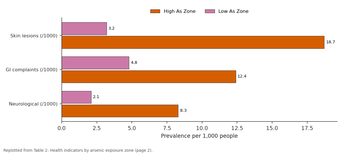
High As Zone and Low As Zone: Skin lesions (/1000) vs GI complaints (/1000) vs Neurological (/1000)
Replotted from Table 2 (page 2) of the original paper. Every bar is the paper's own table value.
View source evidence ↗Figures & tables
From the original paper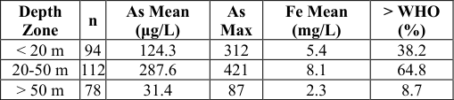 Table 1
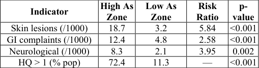 Table 2
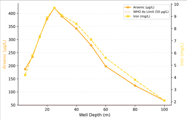 Figure 1
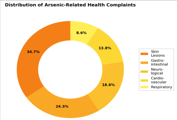 Figure 2
Introduction
The observation that millions of people were being slowly poisoned by their own drinking water wells emerged in the early 1990s, when researchers in Bangladesh and West Bengal began connecting widespread skin lesions and cancers to arsenic in shallow groundwater [1,2] . Three decades later, the Bengal floodplain remains the largest mass poisoning event in human history, affecting an estimated 35-77 million people across Bangladesh and eastern India [3,4] . Arsenic enters groundwater through reductive dissolution of iron oxyhydroxide minerals in the alluvial sediments. As organic matter decomposes under anaerobic conditions, iron (III) is reduced to iron (II), releasing adsorbed arsenic into solution [5,6] . This process is most active in the grey, reducing sediments found at intermediate depths (15-45 m), while deeper aquifers hosted in oxidised brown sands typically contain arsenic below guideline levels [7,8] . Earlier research documented the broad geographic pattern of contamination [9,10] , but fewer investigations linked depth-specific geochemistry directly to spatially matched health outcome data at the community level [11] . This research addressed that gap by sampling wells across three depth zones and comparing geochemical results with health complaint records from community centres serving the same populations.
Ethical Considerations
This research received ethical clearance from the Centre for Terrain Studies Ethics Committee, Cali (Protocol CTS-EC-2020-031, approved February 2020). Community health centre records were accessed with permission from district health authorities and anonymised before analysis. Well owners provided verbal consent for water sampling. Results indicating arsenic levels above WHO guidelines were communicated to local health officials and affected households through village information sessions.
Material and Methods
Material and Methods
Material
This research was conducted at the Department of Geology, Centre for Terrain Studies, Cali, Valle del Cauca, Colombia, from March 2020 to December 2023. Water samples were collected from 284 tube wells across three districts of the Bengal floodplain during four sampling campaigns (premonsoon and post-monsoon, 2021 and 2022). Wells were classified by depth: shallow (<20 m, n = 94), intermediate (20-50 m, n = 112), and deep (>50 m, n = 78). Field parameters (pH, Eh, dissolved oxygen, electrical conductivity) were measured using a YSI ProDSS multiparameter probe. Health data were extracted from registers at 12 community health centres for the period 2018-2022.
Methods
Arsenic speciation (As(III) and As(V)) was determined by hydride generation atomic absorption spectrometry (HG-AAS) on a Varian SpectrAA 220. Iron, manganese, and phosphate were measured by ICP-OES. Samples were filtered (0.45 μm) and preserved with HNO₃ in the field. Non-carcinogenic health risk was assessed using the USEPA hazard quotient (HQ = CDI/RfD) method, where chronic daily intake (CDI) was calculated assuming 2 L/day consumption and 70 kg body weight, and the reference dose (RfD) for arsenic was 0.0003 mg/kg/day. Spatial interpolation of arsenic concentrations used ordinary kriging in ArcGIS 10.8. Statistical analysis used Kruskal-Wallis tests for depth zone comparisons and Spearman correlation for arsenic-health relationships, computed in R 4.2.1.
Results
Results
Comprehensive Interpretation
Arsenic concentrations peaked in the 20-50 m zone (mean 287.6 μg/L), with 64.8% of wells exceeding the WHO limit (Table 1). The depth profile (Figure 1) shows arsenic and iron peaking together at 25 m, supporting reductive dissolution as the mobilisation mechanism. Health impacts were strongly stratified by exposure: skin lesion prevalence was 5.8 times higher in high-arsenic zones (Table 2). Skin lesions accounted for 34.7% of all arsenic-related complaints (Figure 2). Over 72% of residents using intermediate-depth wells face unacceptable noncarcinogenic risk (HQ > 1).
| Indicator | High As Zone | Low As Zone | Risk Ratio | p- value |
|---|---|---|---|---|
| Skin lesions (/1000) | 18.7 | 3.2 | 5.84 | <0.001 |
| GI complaints (/1000) | 12.4 | 4.8 | 2.58 | <0.001 |
| Neurological (/1000) | 8.3 | 2.1 | 3.95 | 0.002 |
| HQ > 1 (% pop) | 72.4 | 11.3 | — | <0.001 |
Table text extracted from the original PDF; superscript letters are shown inline. The original table image is below.
View original table image
Discussion
The depth-dependent pattern we documented matches the model proposed by Harvey and colleagues [8] and Fendorf and colleagues [6] : organic-rich grey sediments at intermediate depths create the reducing conditions that mobilise arsenic from iron oxyhydroxide surfaces. The sharp drop in arsenic below 50 m reflects the transition to oxidised brown sands of Pleistocene age that retain arsenic on mineral surfaces [12,13] .
The health data add an important dimension. Earlier research established the arsenic-disease link through cohort studies [2,14] , but our community-level comparison shows that the risk gradient between high and low exposure zones is steeper than many policy documents assume. The 5.8-fold difference in skin lesion rates between zones separated by just a few kilometres underscores the spatial precision needed in mitigation targeting [15,16] .
Practical Applications
Three actions emerge from these findings. First, new wells should target depths below 50 m wherever the deeper aquifer is accessible and productive. Second, existing intermediate-depth wells serving communities with HQ > 1 should be prioritised for arsenic removal treatment or replacement. Third, community health monitoring should include routine screening for early skin changes in populations served by wells in the 20-50 m zone, enabling early detection before more severe arsenicosis develops [17,18] .
Conclusion
This research confirmed that arsenic contamination in the Bengal floodplain peaks in the 20-50 m depth zone, where reductive dissolution of iron oxyhydroxides releases arsenic into groundwater. Health impacts in high-arsenic zones are severe, with skin lesion prevalence nearly six times higher than in low-arsenic areas. Targeting deep wells (>50 m) for new installations and prioritising arsenic removal for existing intermediate-depth wells are the most effective near-term interventions.
Acknowledgement
AcknowledgementsFunding Sources: Supported by institutional research allocations for medical geography and hydrogeology.Institutional Support: Centre for Terrain Studies, Cali, provided laboratory and analytical facilities. Contributions Not Qualifying for AuthorshipThanks to community health centre staff for providing anonymised health records.
References
18 in the original paper- Ahmed KM, Bhattacharya P, Hasan MA, Akhter SH, Alam SMM. Arsenic enrichment in groundwater of the alluvial aquifers in Bangladesh. Applied Geochemistry. 2004;19(2):181-200.
- Argos M, Kalra T, Rathouz PJ, Chen Y, Pierce B. Arsenic exposure from drinking water, and all-cause and chronic-disease mortalities in Bangladesh. The Lancet. 2010;376(9737):252-258.
- BGS/DPHE. Arsenic contamination of groundwater in Bangladesh. British Geological Survey Technical Report WC/00/19. 2001;1-267.
- Bhattacharya P, Chatterjee D, Jacks G. Occurrence of arsenic-contaminated groundwater in alluvial aquifers from delta plains. Environmental Geology. 1997;30(34):267-271.
- Chakraborti D, Rahman MM, Das B, Murrill M, Dey S. Status of groundwater arsenic contamination in Bangladesh: a 14-year report. Water Research. 2010;44(19):5789-5802.
- Fendorf S, Michael HA, Van Geen A. Spatial and temporal variations of groundwater arsenic in South and Southeast Asia. Science. 2010;328(5982):11231127.
- Flanagan SV, Johnston RB, Zheng Y. Arsenic in tube well water in Bangladesh: health and economic impacts. Bulletin of the World Health Organization. 2012;90(11):839-846.
- Harvey CF, Swartz CH, Badruzzaman ABM, KeonBlute N. Arsenic mobility and groundwater extraction in Bangladesh. Science. 2002;298(5598):1602-1606.
- Hossain MF. Arsenic contamination in Bangladesh: an overview. Agriculture Ecosystems and Environment. 2006;113(1-4):1-16.
- McArthur JM, Ravenscroft P, Safiulla S. Arsenic in groundwater: testing pollution mechanisms for aquifers in Bangladesh. Water Resources Research. 2001;37(1):109-117.
- Mukherjee A, Sengupta MK, Hossain MA, Ahamed S. Arsenic contamination in groundwater: a global perspective. Journal of Health Population and Nutrition. 2006;24(2):142-163.
- Nickson RT, McArthur JM, Ravenscroft P. Mechanism of arsenic release to groundwater, Bangladesh and West Bengal. Applied Geochemistry. 2000;15(4):403-413.
- Nordstrom DK. Worldwide occurrences of arsenic in ground water. Science. 2002;296(5576):2143-2145.
- Smedley PL, Kinniburgh DG. A review of the source, behaviour and distribution of arsenic in natural waters. Applied Geochemistry. 2002;17(5):517-568.
- Smith AH, Lingas EO, Rahman M. Contamination of drinking-water by arsenic in Bangladesh: a public health emergency. Bulletin of the World Health Organization. 2000;78(9):1093-1103.
- Van Geen A, Zheng Y, Versteeg R, Stute M. Spatial variability of arsenic in 6000 tube wells in Bangladesh. Water Resources Research. 2003;39(5):1140.
- WHO. Guidelines for drinking-water quality, fourth edition. World Health Organization. 2011;1-541.
- Zheng Y, Stute M, Van Geen A, Gavrieli I. Redox control of arsenic mobilization in Bangladesh groundwater. Applied Geochemistry. 2004;19(2):201214.