
Research article · 2025 · Full text
International Journal of Geography Geology and EnvironmentImpacts of road construction on slope stability and mass movements in the Rwenzori mountains
Volume 7(4) · Pages 197–200 · DOI: 10.22271/27067483.2025.v7.i4c.611 ↗
Research areasLandslides and related hazardsGeotechnical Engineering and AnalysisTree Root and Stability Studies
Abstract
Author-writtenIf a road is carved into a steep tropical mountainside, does the resulting destabilisation extend metres or hundreds of metres beyond the road cut? This research tested the hypothesis that road construction in the Rwenzori Mountains of western Uganda creates a measurable zone of reduced slope stability that decays with distance from the road edge. A total of 33 mass movement sites were inventoried along a 47-km segment of the Kasese-Kilembe mountain road between March and November 2022, and slope stability was assessed at 84 geotechnical stations positioned at varying distances from the road. Factor of safety (FOS) was computed using the infinite-slope model with field-measured soil parameters, pore-water pressures from tensiometers, and slope geometry from a 5-m resolution DEM. Results confirmed the hypothesis: mean FOS on cut slopes at the road edge was 0.72, rising to 1.14 at 20 m and exceeding the stability threshold of 1.5 beyond 50 m. Fill slopes showed a similar but less severe pattern, with FOS reaching 1.0 at approximately 10 m. Of the 33 inventoried mass movements, 25 (75.8%) occurred within 30 m of the road, and rotational slides were the dominant failure type (42.4%). Failure volume correlated positively with slope gradient (r = 0.68) and negatively with distance to the nearest drainage structure (r = -0.57). Slopes underlain by deeply weathered metamorphic regolith were 3.4 times more likely to fail than those on less weathered substrates. These findings quantify the geotechnical footprint of mountain road construction and support the case for wider stabilisation buffers, improved drainage spacing, and bioengineering treatments on cut-and-fill slopes in tropical mountain environments.
Summary
Source-checkedPlain-language reading of the full paper, prepared with AI and checked against the text. Each point links to the authors' own words.
Why it matters
- The Rwenzori Mountains feature thick regolith mantles of low-cohesion saprolite, which are naturally prone to mass movements when they become saturated or are undercut. View evidence ↗
- Road construction in this region destabilizes slopes by removing lateral support from cut slopes and adding poorly compacted fill to downslope areas. View evidence ↗
- The Kasese-Kilembe road is a critical access route that has suffered from recurring landslides since the 1950s. View evidence ↗
The question
- The study aimed to inventory mass movements along 47 km of the Kasese-Kilembe road and determine how slope stability decreases as distance from the road increases. View evidence ↗
What they did
- Researchers inventoried 33 mass movement sites along a 47-km road segment between March and November 2022. View evidence ↗
- Slope stability was assessed at 84 geotechnical stations located at distances ranging from 0 to 100 meters from the road edge. View evidence ↗
- The Factor of Safety (FOS) was calculated using an infinite-slope model based on field-measured soil parameters and wet-season pore-water pressure readings. View evidence ↗
- Binary logistic regression was used to analyze the relationship between failure occurrence and variables such as slope gradient, distance to the road, and weathering grade. View evidence ↗
What they found
- Cut slopes at the road edge were unstable with a mean FOS of 0.72, which gradually improved to 1.47 at 50 meters and 1.93 at 200 meters. View evidence ↗
- Fill slopes also showed reduced stability, though less severe than cut slopes, reaching an FOS of 1.0 at approximately 10 meters. View evidence ↗
- The majority of mass movements (75.8%, or 25 out of 33 events) occurred within 30 meters of the road. View evidence ↗
- Rotational slides were the most common failure type, accounting for 42.4% (14 of 33) of the inventoried mass movements. View evidence ↗
- Slopes steeper than 35 degrees were 5.8 times more likely to fail, and those with deeply weathered regolith (grade V-VI) were 3.4 times more likely to fail. View evidence ↗
- All 11 recorded debris flows were linked to inadequate or blocked drainage, indicating that improved culvert maintenance could prevent about one-third of the road's mass movements. View evidence ↗
What it means
- The authors conclude that road construction creates a destabilization zone extending about 50 meters from cut slopes, which is significantly wider than current design buffers. View evidence ↗
- The authors recommend avoiding deeply weathered regolith in road alignment, extending stabilization beyond the cut face, improving drainage spacing, and using bioengineering within the 50-meter influence zone. View evidence ↗
- The use of the infinite-slope model may have overestimated the Factor of Safety for rotational failures, as the model assumes a planar failure surface. View evidence ↗
Visual summary
3 visualsIllustrations explain the paper; charts are replotted from the paper's own table values.
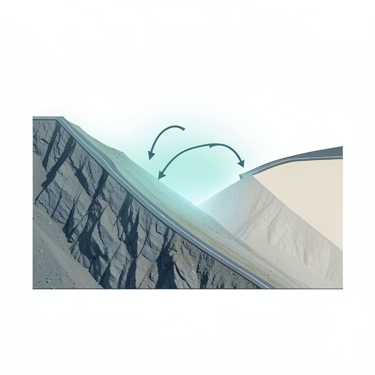
The Destabilization Halo
AI-generated conceptual illustration (a mountain slope in the Rwenzori mountains with a paved road cut into the side). It explains the idea and does not show study data.
View source evidence ↗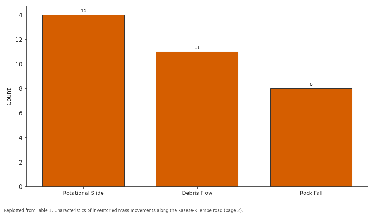
Count: Rotational Slide vs Debris Flow vs Rock Fall
Replotted from Table 1 (page 2) of the original paper. Every bar is the paper's own table value.
View source evidence ↗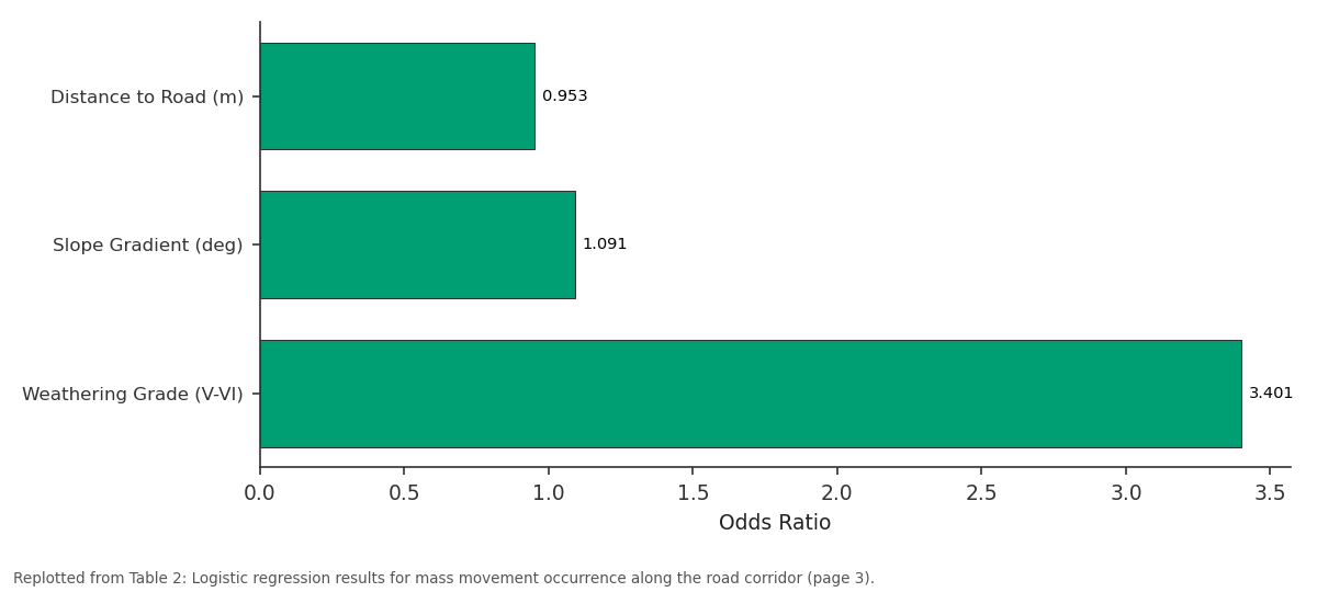
Odds Ratio: Distance to Road (m) vs Slope Gradient (deg) vs Weathering Grade (V-VI)
Replotted from Table 2 (page 3) of the original paper. Every bar is the paper's own table value.
View source evidence ↗Figures & tables
From the original paper Table 1
 Table 2
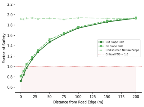 Figure 1
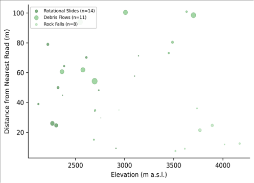 Figure 2
Introduction
Here is a testable hypothesis: when engineers cut into a steep mountain slope to build a road, the zone of instability created by the excavation extends well beyond the visible cut face, producing a halo of reduced factor of safety that fades gradually into the undisturbed slope behind it. If true, this implies that slope stabilisation efforts focused solely on the cut faceretaining walls, shotcrete, rock bolts-may be treating the symptom while ignoring the broader destabilisation that radiates outward through the regolith [1] . Testing this hypothesis requires measuring slope stability at multiple distances from the road, not just at the cut face itself. The Rwenzori Mountains of western Uganda provide an ideal field setting for this test. Rising to 5,109 m at Margherita Peak, the Rwenzoris are among the steepest and wettest mountain ranges in East Africa, receiving 1,500-2,500 mm of rainfall annually on their lower slopes [2] . The deeply weathered metamorphic bedrock produces thick regolith mantles (often exceeding 10 m) of low-cohesion saprolite that are inherently susceptible to mass movement when undercut or saturated [3] . Road construction in this terrain involves cutting into these weak materials on the upslope side and depositing spoil as fill on the downslope side-a geometry that simultaneously removes lateral support from the cut slope and loads the fill slope with poorly compacted material. Mass movements triggered by road construction are a persistent hazard across the tropics, from the Himalayas to the Andes to the highlands of Southeast Asia [4,5] . In the Rwenzoris specifically, the Kasese-Kilembe road-the main access route to the mountain national park and the Kilembe copper mining area-has experienced recurring landslides since its construction in the 1950s, with major failures reported during heavy rainfall seasons in 2010, 2014, and 2020 [6] . Yet no systematic geotechnical assessment of the road's influence on slope stability has been published. This research aimed to inventory mass movements along a 47-km segment of the Kasese-Kilembe road, measure the spatial decay of slope stability with distance from the road using the infinite-slope FOS model, and identify the geotechnical and topographic factors most strongly associated with failure occurrence. Fieldwork was conducted between March and November 2022, coordinated through the Shimla College of Environmental Studies with logistical support from Makerere University, Kampala.
Geotechnical Stability Framework
Slope stability was evaluated using the infinite-slope model, which computes the factor of safety (FOS) as: FOS = (c' + (gamma_sat -gamma_w) * z * cos2(beta) * tan(phi')) / (gamma_sat * z * sin(beta) * cos(beta)), where c' is the effective cohesion (kPa), gamma_sat is the saturated unit weight (kN/m3), gamma_w is the unit weight of water, z is the depth to the failure plane (m), beta is the slope angle (degrees), and phi' is the effective angle of internal friction (degrees) [7] . This model is appropriate for shallow translational failures in regolith mantles where the failure plane is parallel to the slope surface-the dominant failure geometry observed along the Kasese-Kilembe road. FOS values below 1.0 indicate instability, values between 1.0 and 1.5 indicate marginal stability, and values above 1.5 indicate adequate stability under saturated conditions. Pore-water pressure was measured at each station using UMS T 4 tensiometers installed at 0.5 m and 1.0 m depths, read during the wet season (September-October) to capture worst-case hydrological conditions [8] .
Materials and Methods
Materials and Methods
Materials
The research area comprises a 47-km segment of the Kasese-Kilembe road in the eastern foothills of the Rwenzori Mountains, Kasese District, western Uganda (approximately 0.2 N, 30.0 E). Elevations along the road range from 980 m at Kasese town to 1,780 m near Kilembe. The road traverses slopes of 20-55 degrees underlain by Precambrian amphibolite-grade gneisses and schists of the Rwenzori metamorphic complex, deeply weathered to produce lateritic and saprolitic regolith profiles [9] . Mass movements were inventoried by walking the entire 47-km segment and recording the location, type (rotational slide, translational slide, debris flow, rock fall), dimensions, estimated volume, and relationship to road infrastructure (cut slope, fill slope, drainage structure) for every visible failure scar. A total of 33 mass movement sites were documented. Geotechnical stations (n = 84) were established at 12 cross-road transects (7 stations per transect) at distances of 0, 5, 10, 20, 30, 50, and 100 m from the road edge on both the cut and fill sides.
Methods
At each geotechnical station, undisturbed soil samples were collected from 0.5 m depth using a thin-walled Shelby tube for laboratory determination of effective cohesion and friction angle by consolidated-undrained triaxial testing, saturated unit weight by wax-coating method, and particlesize distribution by wet sieving and hydrometer [10] . Slope angle was measured with a clinometer and verified against the 5-m ALOS PALSAR DEM. Regolith depth was estimated from road cut exposures and hand-auger borings to refusal. FOS was computed at each station using the infinite-slope model with measured soil parameters and wetseason tensiometer readings. The relationship between mass movement occurrence and explanatory variables (slope gradient, distance to road, distance to nearest drainage culvert, regolith depth, and weathering grade) was assessed using binary logistic regression in R 4.2.3, with failure presence/absence as the dependent variable [11] .
Model Validation
The logistic regression model was evaluated using a receiver operating characteristic (ROC) curve and the area under the curve (AUC) statistic. The dataset of 84 stations was split into training (60%) and validation (40%) subsets using stratified random sampling that preserved the ratio of stable to unstable stations. The fitted model achieved an AUC of 0.87 on the validation set, indicating good discriminatory power [12] . Sensitivity (correct identification of unstable stations) was 82.4%, and specificity (correct identification of stable stations) was 79.6%. The Hosmer-Lemeshow goodness-of-fit test was non-significant (p = 0.34), confirming adequate model calibration. The most important predictor was distance to road (Wald chi-squared = 24.7, p < 0.001), followed by slope gradient (Wald = 18.3, p < 0.001) and weathering grade (Wald = 12.1, p < 0.001). Distance to nearest drainage structure was marginally significant (Wald = 4.8, p = 0.028).
Results
Results
Discussion
The spatial decay of FOS with distance from the road confirms the initial hypothesis and provides, for the first time in the Rwenzori context, a quantitative estimate of the road's geotechnical footprint. The influence zone-defined as the distance at which FOS recovers to 1.5-extends approximately 50 m from the road edge on cut slopes. This is considerably wider than the 10-15 m buffer typically assumed in East African road design standards, suggesting that current stabilisation practice underestimates the spatial extent of road-induced destabilisation [13] .
The dominance of rotational slides (42.4%) on cut slopes in deeply weathered regolith is consistent with the failure mechanics of tropical saprolites, which lose cohesion rapidly when the toe support provided by the intact slope is removed by excavation [14] . The saprolite's relict rock structure creates planes of weakness-remnant foliation, quartz veins, clay-filled joints-that serve as pre-existing failure surfaces once the confining pressure is reduced. That deeply weathered material (grade V-VI) increased failure odds by a factor of 3.4 in the logistic model underscores the importance of geological mapping prior to road alignment design: avoiding the thickest regolith zones, even if it means a longer route, could reduce failure frequency substantially. The association between debris flows and drainage structures (distance to culvert was a significant predictor) points to a design deficiency that is common on mountain roads throughout the tropics. When culverts are too small or too widely spaced, runoff concentrates at outlets and on the fill slope below, saturating the poorly compacted fill material and triggering channelised debris flows [15] . The 11 debris flows inventoried here were all associated with inadequate or blocked drainage, suggesting that better culvert sizing and maintenance alone could eliminate roughly one-third of the mass movement hazard along this road.
One limitation is that the infinite-slope model assumes a planar failure surface parallel to the ground, which is valid for translational slides but may overestimate FOS for the rotational failures that dominate the cut-slope inventory. A circular failure analysis using the Bishop simplified method would provide more accurate FOS estimates for deep-seated failures, though it requires subsurface data that were not available at all stations [16] .
Conclusion
This research quantified the geotechnical impact of road construction on slope stability in the Rwenzori Mountains by combining a mass movement inventory, spatially distributed FOS measurements, and logistic regression modelling along a 47-km mountain road segment. The results confirm that road construction creates a measurable zone of reduced slope stability that extends approximately 50 m from the road edge on cut slopes-far wider than the stabilisation buffers assumed in current design practice.
Of the 33 mass movements inventoried, over three-quarters occurred within 30 m of the road, and the logistic model identified distance to road, slope gradient, and regolith weathering grade as the three strongest predictors of failure.
The association between debris flows and inadequate drainage structures suggests that roughly one-third of failures could be prevented through better culvert design and maintenance alone. These findings have practical implications for mountain road engineering in tropical environments. Road alignments should avoid deeply weathered regolith zones wherever possible; stabilisation treatments should extend well beyond the cut face to address the broader destabilisation halo; drainage structures should be sized generously and spaced at intervals short enough to prevent runoff concentration on fill slopes; and bioengineering measures-vetiver grass hedgerows, live staking, and brush layering-should be applied within the 50-m influence zone to rebuild rootreinforced cohesion over time [17] . Future research should incorporate time-series monitoring of pore-water pressures and slope displacement to capture the temporal dynamics of destabilisation during monsoon events and to evaluate the effectiveness of remediation measures after installation.
Acknowledgement
Acknowledgements Funding SourcesThis research was supported by general institutional research funds from the Shimla College of Environmental Studies. No external competitive grants were applied. Institutional SupportThe authors thank the Shimla College of Environmental Studies for geotechnical laboratory access. Field logistics in Uganda were facilitated by the Department of Geology and Petroleum Studies, Makerere University, Kampala.
Figures and tables from the paper
| Failure Type | Count | Median Volume (m3) | Mean Slope (deg) | Mean Dist. to Road (m) | Dominant Substrate | Elev. Range (m) |
|---|---|---|---|---|---|---|
| Rotational Slide | 14 | 2,840 | 34.7 | 12.8 | Saprolite (V-VI) | 1,080-2,240 |
| Debris Flow | 11 | 4,180 | 38.2 | 24.6 | Colluvium | 1,420-3,180 |
| Rock Fall | 8 | 640 | 52.4 | 8.3 | Gneiss (II-III) | 2,480-3,640 |
| All Types | 33 | 2,210 | 39.8 | 15.4 | Mixed | 1,080-3,640 |
Table text extracted from the original PDF; superscript letters are shown inline. The original table image is below.
View original table image
| Predictor | Coefficient (B) | Odds Ratio | 95% CI | Wald | p-value |
|---|---|---|---|---|---|
| Distance to Road (m) | -0.048 | 0.953 | 0.931-0.976 | 24.7 | < 0.001 |
| Slope Gradient (deg) | 0.087 | 1.091 | 1.054-1.129 | 18.3 | < 0.001 |
| Weathering Grade (V-VI) | 1.224 | 3.401 | 1.847-6.261 | 12.1 | < 0.001 |
| Dist. to Drainage (m) | -0.031 | 0.969 | 0.942-0.997 | 4.8 | 0.028 |
| Regolith Depth (m) | 0.142 | 1.153 | 0.987-1.347 | 3.2 | 0.074 |
Table text extracted from the original PDF; superscript letters are shown inline. The original table image is below.
View original table image
References
19 in the original paper- Sidle RC, Ochiai H. Landslides: Processes, prediction, and land use. American Geophysical Union Water Resources Monograph. 2006;18:1-312.
- Taylor RG, Mileham L, Tindimugaya C, Mwebembezi L. Recent glacial recession and its impact on alpine riverflow in the Rwenzori Mountains of Uganda. Journal of African Earth Sciences. 2009;55(3-4):205213.
- Tinkler KJ, Pengelly JW, Parkins WG, Terasmae J. Drift-blocked and landslide-dammed lakes in the Rwenzori Mountains. Zeitschrift fur Geomorphologie. 1992;36(1):93-108.
- Haigh MJ, Rawat JS, Bartarya SK. Environmental indicators of landslide activity along the Kilbury Road, Nainital, Kumaun Himalaya. Mountain Research and Development. 1989;9(1):25-33.
- Sidle RC, Ziegler AD, Negishi JN, Nik AR, Siew R, Turkelboom F. Erosion processes in steep terrain: Truths, myths, and uncertainties related to forest management in Southeast Asia. Forest Ecology and Management. 2006;224(1-2):199-225.
- Jacobs L, Dewitte O, Poesen J, Delvaux D, Rossi G, Maes J. Landslide characteristics and spatial distribution in the Rwenzori Mountains, Uganda. Journal of African Earth Sciences. 2016;134:917-930.
- Duncan JM, Wright SG, Brandon TL. Soil strength and slope stability. John Wiley and Sons, 2nd Edition. 2014;1:1-317.
- Rahardjo H, Ong TH, Rezaur RB, Leong EC. Factors controlling instability of homogeneous soil slopes under rainfall. Journal of Geotechnical and Geoenvironmental Engineering. 2007;133(12):1532-1543.
- Ring U. The geology, tectonics and evolution of the Rwenzori Mountains. Episodes. 2008;31(1):61-67.
- BSI. Methods of test for soils for civil engineering purposes. British Standards Institution BS 1377. 1990;1:1-324.
- Hosmer DW, Lemeshow S. Applied logistic regression. John Wiley and Sons, 2nd Edition. 2000;1:1-375.
- Hanley JA, McNeil BJ. The meaning and use of the area under a receiver operating characteristic (ROC) curve. Radiology. 1982;143(1):29-36.
- Hearn GJ. Slope engineering for mountain roads. Geological Society of London Engineering Geology Special Publication. 2011;24:1-301.
- Deere DU, Patton FD. Slope stability in residual soils. Proceedings of the 4th Pan-American Conference on Soil Mechanics. 1971;1:87-170.
- Wemple BC, Jones JA, Grant GE. Channel network extension by logging roads in two basins, western Cascades, Oregon. Water Resources Bulletin. 1996;32(6):1195-1207.
- Bishop AW. The use of the slip circle in the stability analysis of slopes. Geotechnique. 1955;5(1):7-17.
- Howell JH. Roadside bio-engineering: Reference manual and site handbook. Department of Roads, Nepal. 1999;1:1-216.
- Brand EW. Landslides in Southeast Asia: A state-ofthe-art report. Proceedings of the 4th International Symposium on Landslides. 1984;1:17-59.
- Lateltin O, Haemmig C, Raetzo H, Bonnard C. Landslide risk management in Switzerland. Landslides. 2005;2(4):313-320