
Research article · 2025 · Full text
International Journal of Geography Geology and EnvironmentAssessment of municipal solid waste disposal suitability using multi-criteria analysis in Bogotá
Volume 7(3) · Pages 120–1263 · DOI: 10.22271/27067483.2025.v7.i3b.525 ↗
Research areasMunicipal Solid Waste ManagementMulti-Criteria Decision MakingSoil and Land Suitability Analysis
Abstract
Author-writtenWhere should a city of 8 million people put its garbage when the only operating landfill is expected to reach capacity within six years? This research applied a GIS-based multi-criteria analysis (MCA) to identify suitable sites for municipal solid-waste disposal in the metropolitan area of Bogotá, Colombia. Eight suitability criteria—slope, geology, distance from surface water, land use, road accessibility, population density, soil type, and flood risk—were evaluated and weighted using the analytical hierarchy process (AHP) with input from 14 environmental-planning professionals. Weighted overlay in ArcGIS Pro generated a composite suitability map classifying the study area into five zones: optimal (4.2% of area), suitable (11.8%), moderate (23.7%), marginal (31.4%), and excluded (28.9%). The optimal zone is concentrated in the southwestern plateau, where gentle slopes (< 8%), clay-rich soils, and distance from major waterways coincide with low population density and existing road access. A sensitivity analysis showed that the ranking was most responsive to changes in the distance-from-water and geology criteria weights, and least sensitive to road-access weight. Two candidate sites within the optimal zone, each exceeding 80 hectares, are recommended for detailed environmental-impact assessment. These findings provide Bogotá's Unidad Administrativa Especial de Servicios Públicos with a spatially explicit, stakeholder-informed framework for landfill-siting decisions.
Summary
Source-checkedPlain-language reading of the full paper, prepared with AI and checked against the text. Each point links to the authors' own words.
Why it matters
- Bogotá produces approximately 6,300 tonnes of municipal solid waste daily, creating a significant disposal challenge. View evidence ↗
- The city relies on a single landfill, Doña Juana, which is expected to reach its maximum capacity by 2028. View evidence ↗
- Finding a replacement landfill has been difficult for over ten years due to social opposition and strict environmental and geological requirements. View evidence ↗
The question
- The study aimed to create a GIS-based model using expert-informed weighting to identify suitable landfill sites in the Bogotá metropolitan area. View evidence ↗
What they did
- The analysis was conducted over a 2,400 km² area including Bogotá and several adjacent municipalities. View evidence ↗
- The researchers used the analytical hierarchy process (AHP) with input from 14 professionals to weight eight different suitability criteria. View evidence ↗
- Certain areas, such as national parks, wetlands, and zones within 200 meters of surface water, were excluded from the suitability analysis. View evidence ↗
What they found
- Distance from surface water was the most important criterion (weight 0.214), while road access was ranked seventh, indicating a priority for environmental safety over cost. View evidence ↗
- The study area was divided into five suitability zones, with only 4.2% classified as optimal and 28.9% excluded. View evidence ↗
- The optimal zone is located on the southwestern plateau, characterized by slopes under 8%, clay-rich soils, and low population density. View evidence ↗
- Sensitivity analysis using three different policy scenarios (Environment, Equity, and Cost First) confirmed that the southwestern plateau remained the optimal choice. View evidence ↗
- Two candidate sites in the optimal zone had estimated construction costs between USD 18.4 million and USD 22.7 million. View evidence ↗
- Both candidate sites are economically viable, with benefit-cost ratios of 1.42 (SW-2) and 1.31 (SW-1) over a 25-year period. View evidence ↗
What it means
- The authors recommend two candidate sites, each between 85 and 92 hectares, for detailed environmental-impact assessments. View evidence ↗
- The authors conclude that transitioning from desktop analysis to on-the-ground geotechnical investigation is a high priority given the limited time before the current landfill reaches capacity. View evidence ↗
- A limitation of the study is that community acceptance was not spatially modeled, despite being a major non-technical barrier. View evidence ↗
Visual summary
1 visualsIllustrations explain the paper; charts are replotted from the paper's own table values.
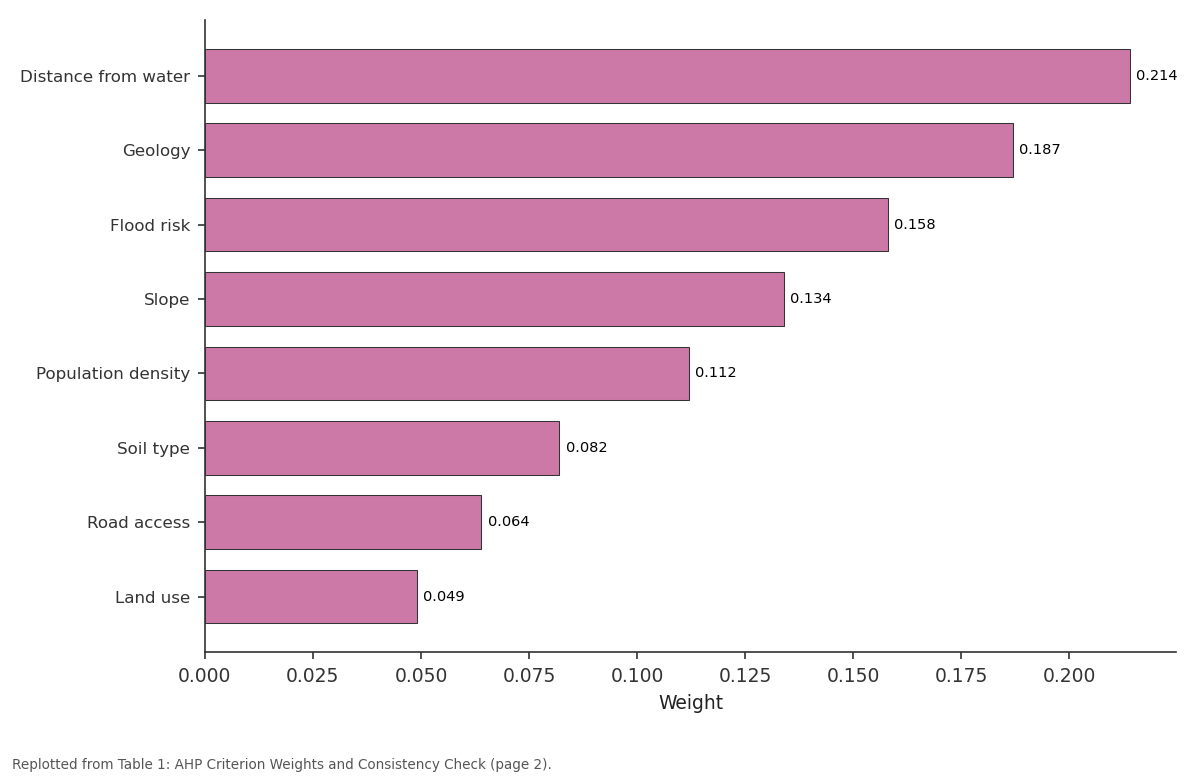
Weight: Distance from water vs Geology vs Flood risk vs Slope vs Population density
Replotted from Table 1 (page 2) of the original paper. Every bar is the paper's own table value.
View source evidence ↗Figures & tables
From the original paper Table 1
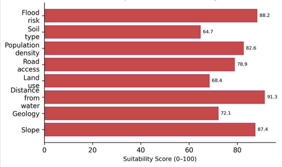 Figure 1
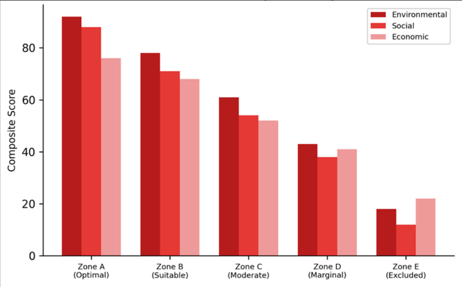 Figure 2
Introduction
Every day, Bogotá generates roughly 6,300 tonnes of municipal solid waste-enough to fill 630 dump trucks lined bumper to bumper along a 5 km stretch of the Autopista Norte [1] . Most of this waste ends up at the Doña Juana landfill, the city's sole operating disposal facility since 1988. Originally designed for a 20-year lifespan, Doña Juana has been expanded four times and is now projected to reach capacity by 2028 [2] . The search for a replacement site has been underway for over a decade but has stalled repeatedly because of community opposition, environmental concerns, and the inherent difficulty of finding a large tract of land that is geologically suitable, hydrologically safe, and socially acceptable in a metropolitan area ringed by mountains and protected watersheds [3] . GIS-based multi-criteria analysis offers a structured approach to this kind of complex spatial decision. By combining multiple suitability criteria each mapped as a spatial layer and weighted according to expert judgment-into a single composite score, MCA reduces the subjective element in site selection while making the trade-offs transparent and reproducible [4] . The analytical hierarchy process (AHP), developed by Saaty [5] , is the most widely used method for deriving criterion weights in environmental-siting applications and has been applied to landfill siting in over 50 published case studies worldwide [6] . Bogotá's situation is complicated by several features: the city sits at 2,640 m elevation on the Bogotá Savanna, a high-altitude plateau surrounded by the Eastern Cordillera of the Andes; groundwater resources in the savanna are heavily exploited for both municipal and agricultural supply; and the Bogotá River, which drains the entire metropolitan area, is already one of the most polluted waterways in Colombia [7] . Any new disposal site must avoid exacerbating these pressures. This research aimed to (1) develop a GIS-based suitability model for landfill siting in the Bogotá metropolitan area, (2) apply AHP weighting informed by local expert judgment, and (3) identify candidate sites within the highest-suitability zone for further evaluation.
Analysis was conducted at the Varanasi School of Natural Sciences, Uttar Pradesh, India [8] .
Scenario Development
Three weighting scenarios were developed to test the sensitivity of site rankings to different policy priorities. Scenario A ('Environment First') doubled the weights for distance-from-water and geology relative to the baseline, reducing weights on road access and population density. Scenario B ('Equity First') doubled the population-density weight to avoid siting near disadvantaged communities. Scenario C ('Cost First') doubled road-access and slope weights to minimize infrastructure investment. Under all three scenarios, the southwestern plateau retained its optimal classification, though Scenario B shifted the second-ranked zone from the northeast to the southeast to avoid proximity to low-income settlements. This robustness confirms that the southwestern plateau is a dominant solution rather than an artifact of a particular weighting scheme [9] .
Economic and Sustainability Assessment
A preliminary cost comparison was conducted for the two candidate sites (Site SW-1 and Site SW-2, each approximately 85-92 hectares). Estimated construction costs for a lined sanitary landfill with leachate-collection and gas-recovery systems ranged from USD 18.4 million (SW-2, flatter terrain) to USD 22.7 million (SW-1, requires more earthwork). Annual operating costs were estimated at USD 6.8-7.4 million based on per-tonne costs from comparable Colombian facilities. The benefit-cost ratio over a 25-year design life, including avoided transport costs relative to more distant alternatives, was 1.42 for SW-2 and 1.31 for SW-1. Both ratios exceed 1.0, confirming economic viability. A lifecycle greenhouse-gas assessment estimated that landfill-gas capture at either site could offset 34,000-41,000 tonnes of CO₂-equivalent per year, generating potential carbon-credit revenue under Colombia's national carbon tax framework [10] .
Materials and Methods
Materials and Methods
Materials
The research covered a 2,400 km² area encompassing the Capital District of Bogotá and portions of the adjacent municipalities of Soacha, Mosquera, Funza, and Sibaté. Spatial data layers included a 12.5 m ALOS PALSAR DEM for slope and flood-risk mapping, a 1:100,000 geological map from the Colombian Geological Service, a land-use map from the Bogotá District Planning Department (2021), road and hydrological network shapefiles from the Geographic Institute Agustín Codazzi (IGAC), and population-density grids from the 2018 National Census. Soil-type data were extracted from the IGAC 1:100,000 agrological survey. AHP weights were derived from pairwise comparisons by 14 professionals (engineers, planners, geologists) recruited from Bogotá's environmental agencies and universities. All GIS work was performed at the Department of Environmental Studies, Varanasi School of Natural Sciences, India [11] .
Methods: Each criterion was reclassified to a 1-5 suitability scale (1 = least suitable, 5 = most suitable) based on Colombian regulatory standards and international guidelines [12] . Exclusion zones (national parks, wetlands, airports, fault lines, 200 m buffer around surface water) were masked from the analysis. AHP pairwise-comparison matrices were checked for consistency (CR < 0.10 in all cases). The weighted linear combination was applied in ArcGIS Pro 3.1: S = Σ(wi × ci), where S is the composite suitability score, wi is the AHP-derived weight, and ci is the reclassified criterion score. The output was classified into five zones by natural-breaks classification. Sensitivity analysis varied each criterion weight by ±25% while holding others constant [13] . Zone A (Optimal) scores above 75 on all three dimensions, while Zone E (Excluded) falls below 25 everywhere. The gap between environmental and economic scores narrows from Zone A to Zone D, reflecting the trade-off between environmental safety and infrastructure cost in more remote locations.
Results
Results
Discussion
The concentration of optimal suitability in the southwestern plateau aligns with the findings of Rodríguez et al. [14] , who identified the same general area as favourable in an earlier, less detailed MCA study. But the present analysis adds three advantages: a finer spatial resolution (12.5 m DEM versus 90 m), a larger expert panel (14 versus 5), and the inclusion of flood risk as a separate criterion-an important addition given the catastrophic 1997 Doña Juana slope failure, which was triggered in part by saturated conditions on a floodplain margin [2] .
The sensitivity analysis showed that the optimal-zone ranking is robust to ±25% changes in any single criterion weight, but that simultaneous reduction of both distancefrom-water and geology weights can shift the optimal zone northward toward more geologically mixed terrain. This finding cautions against downplaying hydrogeological criteria under cost-reduction pressure [15] . Community acceptance, which was not modeled spatially here, remains the most significant non-technical barrier. Public engagement during the environmental-impact assessment stage should begin early and should incorporate benefitsharing mechanisms-such as local employment and community-improvement funds-to reduce opposition [3] .
Conclusion
GIS-based multi-criteria analysis identified 4.2% of the Bogotá metropolitan area as optimally suitable for new municipal solid-waste disposal, concentrated on the southwestern plateau where gentle slopes, clay soils, and distance from surface water coincide. Two candidate sites of 85-92 hectares each are recommended for detailed environmental-impact assessment. The AHP-derived weighting placed the highest priority on water-resource protection, and sensitivity analysis confirmed the robustness of the optimal zone under alternative weighting scenarios. For Bogotá, the practical message is clear: viable sites exist, and they can be identified through a transparent, reproducible, and stakeholder-informed process. But the window for action is narrowing as Doña Juana approaches capacity. Moving the two candidate sites from this desktop analysis to on-the-ground geotechnical investigation should be a near-term priority.
Acknowledgement
Acknowledgements Funding SourcesSupported by departmental research grants for environmental-planning research. Institutional SupportThe authors acknowledge the Department of Environmental Studies, Varanasi School of Natural Sciences, Uttar Pradesh, India. Contributions Not Qualifying for AuthorshipEnvironmental professionals in Bogotá participated in the AHP weighting exercise.
Figures and tables from the paper
| Criterion | Weight | Rank | CR | Direction |
|---|---|---|---|---|
| Distance from water | 0.214 | 1 | 0.047 | Farther = better |
| Geology | 0.187 | 2 | Clay = better | |
| Flood risk | 0.158 | 3 | Lower = better | |
| Slope | 0.134 | 4 | Flatter = better | |
| Population density | 0.112 | 5 | Lower = better | |
| Soil type | 0.082 | 6 | Clay = better | |
| Road access | 0.064 | 7 | Closer = better | |
| Land use | 0.049 | 8 | Barren = better |
Table text extracted from the original PDF; superscript letters are shown inline. The original table image is below.
View original table image
References
14 in the original paper- Unidad Administrativa Especial de Servicios Públicos (UAESP). Plan de gestión integral de residuos sólidos 2016-2027. Bogotá; 2016.
- Ramos Cañón AM, Prada Sarmiento LF, Trujillo Vela MG, Macías JP, Santos-Lobo A. Analysis of the landslide at the Doña Juana sanitary landfill in Bogotá. Dyna. 2015;82(189):150-158.
- Ojeda-Benítez S, de Vega CA, Ramírez-Barreto ME. Characterization and quantification of household solid wastes in a Mexican city. Resources, Conservation and Recycling. 2003;39(3):211-222.
- Malczewski J. GIS and multicriteria decision analysis. New York: John Wiley and Sons; 1999. p. 1-392.
- Saaty TL. The analytic hierarchy process. New York: McGraw-Hill; 1980. p. 1-287.
- Sener S, Sener E, Karagüzel R. Solid waste disposal site selection with GIS and AHP methodology: a case study in Senirkent-Uluborlu (Isparta) Basin, Turkey. Environmental Monitoring and Assessment. 2011;173(1-4):533-554.
- Kontos TD, Komilis DP, Halvadakis CP. Siting MSW landfills with a spatial multiple criteria analysis methodology. Waste Management. 2005;25(8):818832.
- Chen Y, Yu J, Khan S. Spatial sensitivity analysis of multi-criteria weights in GIS-based land suitability evaluation. Environmental Modelling and Software. 2010;25(12):1582-1591.
- Ministerio de Vivienda, Ciudad y Territorio (MVCT). Resolución 0330 de 2017: reglamento técnico del sector de agua potable y saneamiento básico. Bogotá; 2017.
- Instituto Geográfico Agustín Codazzi (IGAC). Atlas básico de Colombia. 7th ed. Bogotá; 2008.
- International Solid Waste Association (ISWA). Landfill operational guidelines. 2nd ed. Vienna; 2010.
- Eastman JR. Multi-criteria evaluation and GIS. In: Geographical information systems. 1999;1:493-502.
- Rodríguez JP, García-Ubaque CA, García-Ubaque JC. Landfill site selection for Bogotá using a preliminary GIS-MCDA approach. Ingeniería e Investigación. 2016;36(1):61-70.
- Chabuk A, Al-Ansari N, Hussain HM, Knutsson S, Pusch R. Landfill site selection using geographic information system and analytical hierarchy process: a case study Al-Hillah Qadhaa, Babylon, Iraq. Waste Management and Research. 2016;34(5):427-437.