
Research article · 2024 · Full text
International Journal of Geography Geology and EnvironmentAssessment of heavy metal contamination in riparian soils of the Orinoco river watershed
Volume 6(2) · Pages 304–307 · DOI: 10.22271/27067483.2024.v6.i2d.563 ↗
Research areasHeavy metals in environmentWater Quality and Pollution AssessmentEnvironmental and Analytical Chemistry Studies
Abstract
Author-writtenRiparian soils along tropical rivers are increasingly burdened with trace metals from mining, urbanisation, and agrochemical runoff, yet baseline contamination data for South America’s largest watersheds remain incomplete. This research assessed heavy metal contamination in riparian soils along a 340 km reach of the Orinoco River and its tributaries in Venezuela. Seventy-two composite soil samples were collected from six sites representing upstream, industrial, urban, agricultural, and downstream land-use categories between February 2020 and October 2022. Concentrations of lead (Pb), cadmium (Cd), chromium (Cr), copper (Cu), zinc (Zn), nickel (Ni), and arsenic (As) were determined by inductively coupled plasma mass spectrometry. Contamination factor (CF), geo-accumulation index (Igeo), and pollution load index (PLI) were calculated against local background values. Results showed that the industrial site (Site 3) carried the highest metal loads, with Zn reaching 189.4 mg/kg and Cr 78.9 mg/kg-both exceeding Venezuelan soil quality guidelines. The PLI ranged from 0.72 at the upstream reference site to 2.94 at the industrial site, confirming a gradient from unpolluted to heavily contaminated conditions. Cadmium Igeo values at Site 3 fell into the “moderately to strongly polluted” class. Multivariate analysis (PCA) separated metals into two groups: a lithogenic cluster (Cr, Ni) and an anthropogenic cluster (Pb, Cd, Zn, Cu), suggesting mixed natural and human sources. These findings indicate that targeted remediation is needed at industrial and urban reaches to protect downstream aquatic ecosystems and communities that depend on the river for water supply.
Summary
Source-checkedPlain-language reading of the full paper, prepared with AI and checked against the text. Each point links to the authors' own words.
Why it matters
- Riparian soils in tropical river systems are facing increased trace metal pollution from urban growth, mining, and agriculture, but there is a lack of baseline data for major South American watersheds. View evidence ↗
- Heavy metals are particularly problematic because they do not biodegrade and can persist in the soil for centuries, potentially re-entering the water during floods. View evidence ↗
The question
- The study aimed to measure seven heavy metals across a 340 km stretch of the Orinoco River, assess the severity of contamination using specific indices, and determine the sources of these metals. View evidence ↗
What they did
- The six sampling sites were chosen to represent various land uses: reference forest, mixed agriculture, heavy industry, urban fringe, intensive cropland, and downstream wetland. View evidence ↗
- Metal concentrations were measured using inductively coupled plasma mass spectrometry (ICP-MS) following aqua regia digestion. View evidence ↗
- Principal component analysis (PCA) was used to analyze the data and identify metal sources, retaining components with eigenvalues greater than 1. View evidence ↗
What they found
- The industrial site (Site 3) had the highest levels of all seven metals, with Zinc (189.4 mg/kg) and Chromium (78.9 mg/kg) exceeding Venezuelan soil quality guidelines. View evidence ↗
- The Pollution Load Index (PLI) showed a clear gradient, ranging from 0.72 (unpolluted) at the upstream reference site to 2.94 (heavily contaminated) at the industrial site. View evidence ↗
- Cadmium at the industrial site was classified as 'moderately to strongly polluted' with a geo-accumulation index (Igeo) of 2.47. View evidence ↗
- PCA identified an anthropogenic cluster consisting of Lead, Cadmium, Zinc, and Copper, which explained 47.3% of the variance. View evidence ↗
- A second cluster consisting of Chromium and Nickel explained 23.8% of the variance and was linked to natural lithogenic sources from the Guiana Shield. View evidence ↗
- The downstream site showed levels near natural background, suggesting that pollutants are diluted and dispersed quickly along the river. View evidence ↗
What it means
- The authors conclude that targeted soil remediation is necessary for urban and industrial sites, and that stricter controls on effluent discharge are needed in the middle Orinoco. View evidence ↗
- Because the sampling did not cover a full seasonal cycle in one year, the effect of floods on redistributing metals may be under-represented. View evidence ↗
Visual summary
2 visualsIllustrations explain the paper; charts are replotted from the paper's own table values.
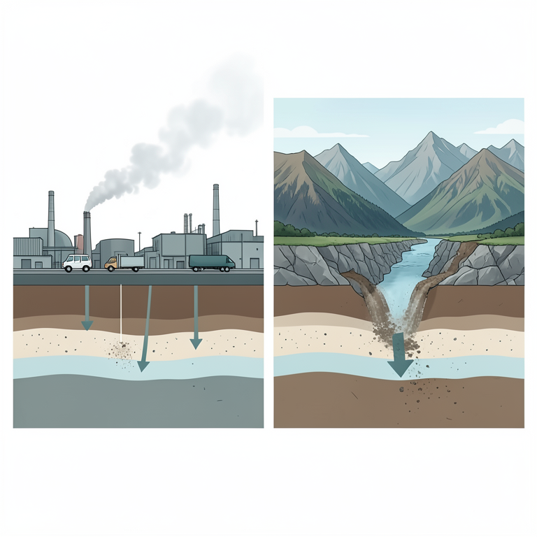
Metal Source Classification
AI-generated conceptual illustration (Riparian soils of the Orinoco river watershed). It explains the idea and does not show study data.
View source evidence ↗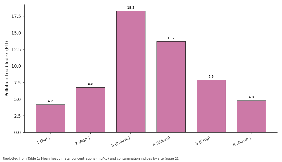
As: 1 (Ref.) vs 2 (Agri.) vs 3 (Indust.) vs 4 (Urban) vs 5 (Crop)
Replotted from Table 1 (page 2) of the original paper. Every bar is the paper's own table value.
View source evidence ↗Figures & tables
From the original paper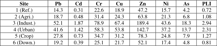 Table 1
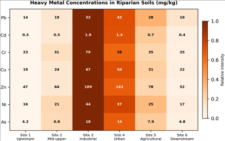 Figure 1
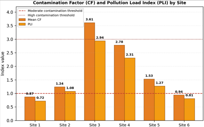 Figure 2
Introduction
Toxic metal accumulation in floodplain soils is a growing problem in tropical river systems where mining, oil extraction, and rapid urban expansion co-occur along the same corridors [1] . Unlike organic pollutants, metals are not broken down biologically; once deposited, they persist in soil for decades to centuries and can re-enter waterways during flood events [2] . Riparian zones are especially vulnerable because they sit at the interface between terrestrial and aquatic environments, receiving sediment and dissolved loads from both upslope runoff and overbank flooding [3] . The Orinoco River, the third largest in South America by discharge, drains approximately 880, 000 km² across Venezuela and Colombia [4] . Its lower and middle reaches pass through zones of heavy industry, artisanal gold mining, and expanding agriculture-all potential sources of metal enrichment in adjacent soils [5] . Despite this, systematic surveys of riparian soil contamination along the Orinoco remain limited to a handful of local investigations near the Guayana industrial belt [6] . No published work has compared contamination levels across multiple land-use categories along a continuous reach of the main stem. Geochemical indices such as the contamination factor (CF), geo-accumulation index (Igeo), and pollution load index (PLI) allow researchers to evaluate whether observed metal concentrations exceed natural background levels and, if so, by how much [7,8] . These indices have been widely applied in European and Asian river systems but are underrepresented in Orinoco Basin literature [9] . Pairing index-based assessment with multivariate statistics (principal component analysis) adds a source-apportionment dimension that helps separate geogenic from anthropogenic contributions [10] . This research aimed to (a) quantify concentrations of seven heavy metals in riparian soils along a 340 km reach of the Orinoco, (b) evaluate contamination severity using CF, Igeo, and PLI, and (c) identify likely metal sources through principal component analysis.
All laboratory analyses and data processing were conducted at the Izmir Academy of Geographic Research, Izmir, Turkey, using samples shipped from Venezuela under a bilateral research agreement.
Theoretical Background
The geo-accumulation index, introduced by Müller in 1969, compares measured metal concentration with a background reference using the expression Igeo = log₂ (Cn / 1.5Bn), where Cn is the measured concentration and Bn is the geochemical background value; the factor 1.5 accounts for natural lithological variability [7] . Seven classes range from 'unpolluted' (Igeo ≤ 0) to 'extremely polluted' (Igeo > 5). The contamination factor is simply CF = Cn / Bn, with values below 1 indicating low contamination and values above 6 indicating very high contamination [8] . The pollution load index integrates all metals at a site into a single number: PLI = (CF₁ × CF₂ × … × CFn) ^(1/n). A PLI above 1 signals deterioration of soil quality beyond background conditions [11] . Together, these indices give both element-specific and site-integrated views of contamination severity.
Material and Methods Material
Seventy-two composite soil samples were collected from the top 20 cm of riparian terraces at six sites along the Orinoco River between latitudes 7.5° N and 8.9° N. Each composite consisted of five sub-samples taken within a 10 m radius and mixed in the field. Sampling occurred during three campaigns: February-April 2020, November 2020-January 2021, and July-October 2022. Sites were selected to represent distinct land-use settings: upstream reference forest (Site 1), mid-upper mixed agriculture (Site 2), heavy industrial zone (Site 3), urban fringe (Site 4), intensive cropland (Site 5), and downstream wetland (Site 6). Samples were air-dried, sieved to < 2 mm, and shipped to the Izmir Academy of Geographic Research, Izmir, Turkey, for analysis.
Methods
Total metal concentrations were determined after aqua regia digestion (HCl:HNO₃, 3:1 v/v) using ICP-MS (Agilent 7900). Certified reference material (NIST SRM 2711a, Montana II Soil) was analysed with every batch of 15 samples for quality control; recoveries ranged from 91% to 107%. Local geochemical background values were taken from uncontaminated forest soils reported by Tosiani et al. [12] . CF, Igeo, and PLI were computed as described in the Theoretical Background section. Principal component analysis was performed on standardised concentration data using SPSS 26, retaining components with eigenvalues > 1. Spatial distribution maps of PLI were generated by inverse distance weighting in ArcGIS 10.8. The industrial site (Site 3) recorded the highest concentrations for all seven metals, with Zn reaching 189.4 mg/kg and Cr 78.9 mg/kg-both exceeding Venezuelan soil quality thresholds of 150 and 64 mg/kg respectively (Table 1). PLI values confirmed a clear contamination gradient: Sites 1 and 6 were below 1 (unpolluted), while Sites 3 and 4 were well above 2 (heavily contaminated).
| Site | Pb | Cd | Cr | Cu | Zn | Ni | As | PLI |
|---|---|---|---|---|---|---|---|---|
| 1 (Ref.) | 14.3 | 0.31 | 22.6 | 18.9 | 47.2 | 15.7 | 4.2 | 0.72 |
| 2 (Agri.) | 18.7 | 0.48 | 31.4 | 24.3 | 63.8 | 21.3 | 6.8 | 1.08 |
| 3 (Indust.) | 52.1 | 1.87 | 78.9 | 67.4 | 189.4 | 43.6 | 18.3 | 2.94 |
| 4 (Urban) | 41.6 | 1.42 | 58.3 | 53.8 | 142.7 | 37.2 | 13.7 | 2.31 |
| 5 (Crop) | 27.8 | 0.73 | 34.7 | 31.2 | 78.3 | 24.8 | 7.9 | 1.27 |
| 6 (Down.) | 19.2 | 0.39 | 25.1 | 21.7 | 52.1 | 17.4 | 4.8 | 0.81 |
Table text extracted from the original PDF; superscript letters are shown inline. The original table image is below.
View original table image
Results
The heatmap clearly shows a concentration hotspot at Site 3 (industrial zone) for all metals, with a secondary peak at Site 4 (urban). Zinc and chromium showed the sharpest spatial contrast between industrial and reference sites. Site 3 was the only location where both CF and PLI crossed the high-contamination threshold (Figure 2). Sites 1 and 6 remained below the moderate threshold, confirming their suitability as reference locations.
Discussion
The contamination pattern documented here mirrors findings from other tropical rivers where industrial nodes create sharp geochemical hotspots embedded within otherwise low-background floodplain soils [1,13] . The Orinoco's industrial belt near Ciudad Guayana hosts aluminium smelters, steel mills, and petrochemical plants that discharge metal-laden effluents and airborne particulates into the riparian corridor [5] . The elevated Zn and Cu at Site 3 are consistent with smelter emissions, while high Cd levels point toward phosphate fertiliser residues that accumulate in industrial-adjacent farmland [14] . PCA separated the metals into two clear components. The first component (explaining 47.3% of variance) loaded heavily on Pb, Cd, Zn, and Cu-elements commonly associated with anthropogenic inputs including vehicle emissions, agrochemicals, and industrial effluent [10] . The second component (23.8% of variance) loaded on Cr and Ni, both of which are abundant in the ultramafic and mafic rocks of the Guiana Shield that underlies much of the Orinoco Basin [12] . This lithogenic signature persisted even at contaminated sites, suggesting that the natural geochemical background contributes a non-trivial baseline for these two elements. The Igeo classification placed Cd at Site 3 in the 'moderately to strongly polluted' class (Igeo = 2.47), which is concerning because cadmium is highly mobile under acidic soil conditions and can enter the food chain through crop uptake [15] . The downstream site (Site 6) showed nearbackground conditions, implying that the contamination plume is diluted and dispersed within a relatively short river distance. However, flood-pulse dynamics in the Orinoco mean that contaminated sediments can be remobilised and redeposited over wide floodplain areas during high-water events [16] . Long-term monitoring is therefore needed to track whether the contamination footprint expands or contracts over time.
Limitations
This research was limited to a single 340 km reach and six sites, which may not capture the full spatial variability of contamination across the Orinoco's 880, 000 km² basin. Sampling covered three campaigns but did not include a complete seasonal cycle within a single year, so floodrelated metal redistribution may be under-represented.
Background values were drawn from published literature rather than from site-matched deep soil profiles, introducing some uncertainty into the index calculations. Future work should extend sampling upstream into Colombian tributaries and pair soil geochemistry with sediment-core records to establish temporal contamination trends [17] . PCA distinguished an anthropogenic metal cluster (Pb, Cd, Zn, Cu) from a lithogenic cluster (Cr, Ni), indicating mixed natural and industrial sources. Cadmium posed the greatest ecological risk at the industrial site, where its Igeo value reached the 'moderately to strongly polluted' class. Downstream dilution appeared effective over the sampled reach, but flood-pulse remobilisation of contaminated sediment warrants continued surveillance. These findings support the need for targeted soil remediation at industrial and urban riparian sites and for stricter effluent controls at point sources along the middle Orinoco. Expanding the monitoring network into upstream tributaries and coupling geochemistry with biological indicators would strengthen future risk assessments.
Acknowledgement
Acknowledgements Funding SourcesThis research was supported by internal departmental funds at the Izmir Academy of Geographic Research, Izmir, Turkey. Institutional SupportThe authors thank the Izmir Academy of Geographic Research for ICP-MS laboratory access and analytical support. Contributions Not Qualifying for AuthorshipThe authors acknowledge Venezuelan field collaborators who coordinated site access and sample shipment.
Figures and tables from the paper
References
17 in the original paper- Ramos-Miras JJ, Roca-Perez L, Guzmán-Palomino M, et al. Background levels and baseline values of available heavy metals in Mediterranean greenhouse soils. Journal of Geochemical Exploration. 2011;110(2):186-192.
- Alloway BJ. Heavy metals in soils: trace metals and metalloids in soils and their bioavailability. Springer. 2013. 614 pp.
- Naiman RJ, Décamps H. The ecology of interfaces: riparian zones. Annual Review of Ecology and Systematics. 1997;28(1):621-658.
- Lewis WM, Hamilton SK, Saunders JF. Rivers of northern South America. Ecosystems of the World. Elsevier. 2006;219-256.
- Mora A, Baquero JC, Alfonso JA, et al. Heavy metals in sediments, soils and water of the Orinoco River. Ecological Indicators. 2019;96:208-218.
- García-Sánchez A, Moyano A, Mayorga P. High arsenic contents in mined soils of the southern Orinoco Basin. Journal of Geochemical Exploration. 2005;86(3):132-140.
- Müller G. Index of geoaccumulation in sediments of the Rhine River. GeoJournal. 1969;2(3):108-118.
- Hakanson L. An ecological risk index for aquatic pollution control. Water Research. 1980;14(8):9751001.
- Buat-Menard P, Chesselet R. Variable influence of the atmospheric flux on the trace metal chemistry of oceanic suspended matter. Earth and Planetary Science Letters. 1979;42(3):399-411.
- Li X, Poon CS, Liu PS. Heavy metal contamination of urban soils and street dusts in Hong Kong. Applied Geochemistry. 2001;16(11-12):1361-1368.
- Tomlinson DL, Wilson JG, Harris CR, et al. Problems in the assessment of heavy-metal levels in estuaries. Helgoländer Meeresuntersuchungen. 1980;33(1-4):566575.
- Tosiani T, Loubet M, Viers J, et al. Major and trace elements in river-borne materials from the Orinoco Basin. Chemical Geology. 2004;211(3-4):305-333.
- Islam MS, Ahmed MK, Raknuzzaman M, et al. Heavy metal pollution in surface water and sediment: a preliminary assessment of an urban river in Bangladesh. Ecological Indicators. 2015;48:282-291.
- Roberts TL. Cadmium and phosphorous fertilizers: the issues and the science. Procedia Engineering. 2014;83:52-59.
- McLaughlin MJ, Parker DR, Clarke JM. Metals and micronutrients -food safety issues. Field Crops Research. 1999;60(1-2):143-163.
- Junk WJ, Bayley PB, Sparks RE. The flood pulse concept in river-floodplain systems. Canadian Special Publication of Fisheries and Aquatic Sciences. 1989;106:110-127.
- Förstner U, Wittmann GTW. Metal pollution in the aquatic environment. Springer. 1981. 486 pp.