
Research article · 2024 · Full text
International Journal of Geography Geology and EnvironmentMorphometric analysis of drainage basins in the Carpathian mountain range using GIS
Volume 6(2) · Pages 296–299 · DOI: 10.22271/27067483.2024.v6.i2d.559 ↗
Research areasGroundwater and Watershed AnalysisGeography and Environmental StudiesHydrology and Watershed Management Studies
Abstract
Author-writtenMountain drainage basins are among the most sensitive geomorphic units on the planet, and their shape, size, and internal network geometry carry direct information about tectonic setting, lithology, and climate history. This research performed a morphometric analysis of 28 drainage basins in the Romanian sector of the Carpathian Mountain Range using GIS-based methods. SRTM digital elevation data (30 m resolution) were processed in ArcGIS 10.8 to extract linear, areal, and relief parameters. Stream ordering followed the Strahler system, and basins ranged from third to sixth order. Bifurcation ratios fell between 2.91 and 5.37, indicating moderate to strong structural control. Drainage density varied from 1.04 to 3.21 km/km², with higher values in areas underlain by impermeable flysch lithologies. Circularity ratios ranged from 0.28 to 0.67, suggesting elongated to semi-circular basin shapes. Relief ratios and ruggedness numbers were highest along the eastern Carpathian arc where recent tectonic uplift is best documented. A negative correlation (r = −0.68) between basin area and drainage density confirmed that larger basins tend to have coarser channel networks. These morphometric signatures offer a rapid screening tool for flood susceptibility and erosion hazard mapping in mountain environments.
Summary
Source-checkedPlain-language reading of the full paper, prepared with AI and checked against the text. Each point links to the authors' own words.
Why it matters
- Mountain drainage basins are highly sensitive geomorphic units whose geometry provides critical data on climate history, lithology, and tectonic settings. View evidence ↗
- Previous research in the region has largely focused on single parameters or individual catchments, leaving a gap in basin-scale morphometric comparisons across the range. View evidence ↗
The question
- The study aimed to compare morphometric parameters across 28 Carpathian basins to evaluate how lithology and tectonics influence these signatures and to test their use in screening for erosion and flood hazards. View evidence ↗
What they did
- The researchers used 30 m resolution SRTM digital elevation data processed in ArcGIS 10.8 to extract relief, areal, and linear parameters. View evidence ↗
- Basin boundaries were delineated using a watershed tool and manually adjusted, while stream ordering was conducted according to the Strahler hierarchy. View evidence ↗
- The study employed Pearson correlation coefficients for parameter pairs and one-way ANOVA at a 0.05 significance level to test groupings by lithological unit. View evidence ↗
What they found
- Bifurcation ratios ranged from 2.91 to 5.37 with a mean of 3.84, suggesting that geological structure exerts moderate to strong control over channel development. View evidence ↗
- Drainage density ranged from 1.04 to 3.21 km/km², with flysch basins showing the highest mean density (2.63 km/km²), indicating a strong lithological influence. View evidence ↗
- The circularity ratios of the basins ranged from 0.28 to 0.67, which indicates shapes varying from elongated to semi-circular. View evidence ↗
- Relief ratios and ruggedness numbers were highest and most variable (CV > 40%) along the eastern Carpathian arc, reflecting recent tectonic uplift and deep incision compared to the Western Carpathians. View evidence ↗
- A significant negative correlation (r = -0.68, p < 0.01) was found between basin area and drainage density, confirming that larger basins typically have coarser channel networks. View evidence ↗
- One-way ANOVA confirmed that drainage density differed significantly across different lithological groups (F = 14.7, p < 0.001). View evidence ↗
- Nine of the 28 basins were identified as high-risk for flash flooding based on high drainage density, high ruggedness, and low circularity; all nine are located in the flysch belt of the Eastern Carpathians. View evidence ↗
What it means
- The authors conclude that morphometric screening is a cost-effective initial method for prioritizing hazard mitigation investments in mountain regions where data is scarce. View evidence ↗
- The authors state that future research should incorporate rainfall intensity records and land-cover change data to transition from static screening to dynamic flood-risk modeling. View evidence ↗
- The study's scope was limited to the Romanian sector; extending the analysis to the Slovak and Ukrainian sectors is suggested for a full arc-scale comparison. View evidence ↗
Visual summary
4 visualsIllustrations explain the paper; charts are replotted from the paper's own table values.
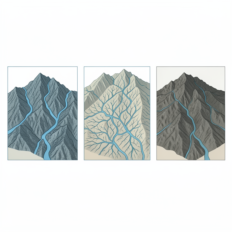
Lithological Influence on Drainage
AI-generated conceptual illustration (Carpathian mountain range drainage basins with crystalline, flysch, and volcanic rock layers). It explains the idea and does not show study data.
View source evidence ↗
Flash Flood Risk Criteria
AI-generated conceptual illustration (Carpathian mountain range drainage basins). It explains the idea and does not show study data.
View source evidence ↗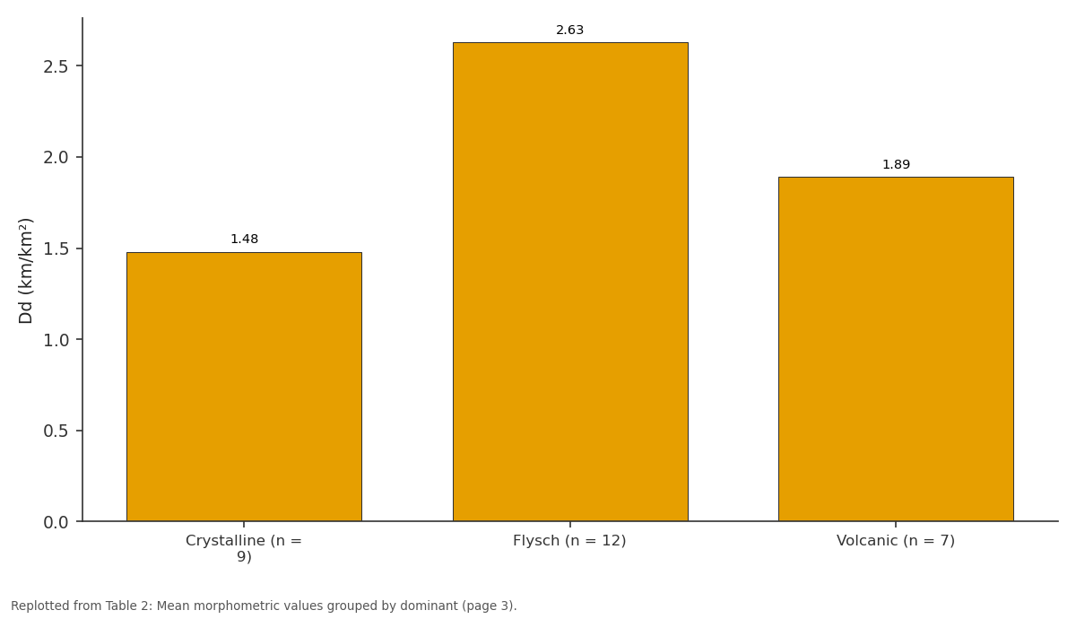
Dd (km/km²): Crystalline (n = 9) vs Flysch (n = 12) vs Volcanic (n = 7)
Replotted from Table 2 (page 3) of the original paper. Every bar is the paper's own table value.
View source evidence ↗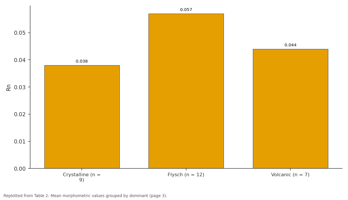
Rh: Crystalline (n = 9) vs Flysch (n = 12) vs Volcanic (n = 7)
Replotted from Table 2 (page 3) of the original paper. Every bar is the paper's own table value.
View source evidence ↗Figures & tables
From the original paper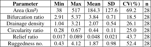 Table 1
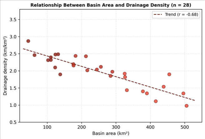 Figure 1
 Table 2
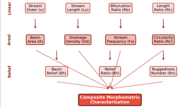 Figure 2
Introduction
Drainage basin morphometry is the quantitative measurement of landscape geometry, and it remains one of the most accessible entry points into understanding how rivers, slopes, and divides interact over geological time [1] . Since Horton first formalised the laws of drainage composition in the 1940s, hundreds of investigations worldwide have applied morphometric indices to rank basin maturity, predict flood response, and infer tectonic influence [2,3] . The approach is especially powerful in mountain regions, where steep gradients and variable lithology produce a wide spread of index values across short distances. The Carpathian Mountains form a 1, 500 km arc across central and eastern Europe, passing through Romania, Ukraine, Poland, Slovakia, and the Czech Republic [4] . The Romanian Carpathians alone contain more than 60 major river basins draining toward the Danube and Black Sea. Despite this, basin-scale morphometric comparisons across the range have been surprisingly few. Most published work has focused on individual catchments or on single morphometric parameters such as hypsometry [5,6] . GIS technology and freely available digital elevation models have removed the main barriers that once limited morphometric research to field-surveyed topographic sheets [7] . Automated stream extraction, basin delineation, and parameter calculation can now be completed in hours rather than months. That said, the reliability of results still depends on DEM resolution, flow-routing algorithms, and threshold choices for channel initiation [8] . This research aimed to (a) extract and compare linear, areal, and relief morphometric parameters for 28 Carpathian drainage basins, (b) evaluate the influence of lithology and tectonic setting on morphometric signatures, and (c) test the practical value of morphometric indices for flood and erosion hazard screening. All analytical work was carried out at the Cairo Institute of Earth Sciences, Cairo Governorate, Egypt, using remote sensing datasets.
Research Area Description
The research focused on the Romanian Carpathians, which are subdivided into the Eastern Carpathians, Southern Carpathians (Transylvanian Alps), and Western Carpathians [4] . Elevations range from 300 m at the mountain fringe to 2, 544 m at Moldoveanu Peak in the Făgăraş massif. The 28 selected basins span all three subdivisions and cover a combined area of approximately 9, 700 km². Basin areas ranged from 38 km² (Topolog basin) to 517 km² (Olt headwaters). Bedrock includes Precambrian crystalline schists in the Southern Carpathians, Cretaceous flysch sequences along the Eastern Carpathian arc, and Neogene volcanic units in the Gutai and Calimani massifs [9] .
Climatic and Environmental Conditions
The Romanian Carpathians experience a temperatecontinental modulated by altitude. Mean annual precipitation ranges from 600 mm at lower elevations to over 1, 200 mm above 1, 800 m [10] . Snowmelt between March and May generates the annual discharge peak in most basins. Summer convective storms also trigger flash floods, particularly in flysch catchments with low infiltration capacity. Vegetation cover shifts from mixed beech-oak forests below 1, 400 m, through spruce-dominated montane forests, to alpine meadows above the treeline at roughly 1, 800 m. Land use in the lower reaches includes pasture and small-scale cropping.
Materials and Methods
Materials and Methods
Materials
Materials
Methods
The DEM was hydrologically conditioned by filling sinks and computing flow direction and accumulation grids. A stream initiation threshold of 250 cells was applied after sensitivity testing against mapped blue-line networks. Stream ordering followed the Strahler hierarchy [2] . Basin boundaries were delineated using the watershed tool and manually adjusted where DEM artefacts caused obvious misrouting. Linear parameters (stream order, number, length, bifurcation ratio, length ratio), areal parameters (basin area, perimeter, drainage density, stream frequency, circularity ratio, elongation ratio), and relief parameters (basin relief, relief ratio, ruggedness number) were calculated using standard formulae [1,3] . Pearson correlation coefficients were computed between all parameter pairs. Statistical grouping of basins by lithological unit was tested with one-way ANOVA at the 0.05 significance level. 1 presents summary statistics for six key parameters across all 28 basins. Relief ratio and ruggedness number showed the highest variability (CV > 40%), reflecting the contrast between deeply incised Eastern Carpathian catchments and the broader, gentler basins of the Western Carpathians. Bifurcation ratios averaging 3.84 fell within the range typical of basins where geological structure exerts moderate control over channel development [3] .
Results
Results
Discussion
The morphometric results reveal a strong lithological fingerprint on drainage patterns in the Carpathians. Flysch sequences, composed of alternating sandstone and shale beds with low matrix permeability, promote rapid surface runoff and denser channel incision [4,11] . Crystalline basement rocks, by contrast, allow greater infiltration and sustain fewer but longer channels. This distinction is consistent with global syntheses showing that rock permeability is a first-order control on drainage density [1] . The bifurcation ratios (mean 3.84) sit close to the theoretical value of 3-5 expected for basins where structure plays a moderate role but does not dominate network geometry [3] .
Values above 5 in a few Eastern Carpathian basins may reflect the influence of NW-SE-trending thrust faults that deflect tributary junctions and create asymmetric networks [9] . The high relief ratios and ruggedness numbers along the eastern arc match independent evidence of Quaternary uplift rates reaching 1-2 mm/yr derived from terrace dating [12] . From a practical standpoint, basins combining high Dd, high Rn, and low Rc values are those most prone to flash flooding and slope erosion. Nine of the 28 basins met all three criteria, and all nine lie within the flysch belt of the Eastern Carpathians-a zone already flagged for recurrent flood damage [13] . Morphometric screening therefore offers a low-cost first step toward prioritising hazard mitigation investments in data-scarce mountain regions.
Conclusion
Conclusion
Acknowledgement
Acknowledgements Funding SourcesThis research was supported by departmental funds at the Cairo Institute of Earth Sciences, Cairo, Egypt. Institutional SupportThe authors thank the Cairo Institute of Earth Sciences for GIS laboratory access and computing resources. Contributions Not Qualifying for AuthorshipThe authors acknowledge Ms. D. Popescu for digitising the Romanian geological map sheets.
Figures and tables from the paper
| Parameter | Min | Max | Mean | SD | CV(%) | n |
|---|---|---|---|---|---|---|
| Area (km²) | 38 | 517 | 184.3 | 127.6 | 69.2 | 28 |
| Bifurcation ratio | 2.91 | 5.37 | 3.84 | 0.71 | 18.5 | 28 |
| Drainage density | 1.04 | 3.21 | 2.07 | 0.54 | 26.1 | 28 |
| Circularity ratio | 0.28 | 0.67 | 0.44 | 0.11 | 25.0 | 28 |
| Relief ratio | 0.017 | 0.089 | 0.048 | 0.021 | 43.7 | 28 |
| Ruggedness no. | 0.43 | 4.12 | 1.87 | 0.98 | 52.4 | 28 |
Table text extracted from the original PDF; superscript letters are shown inline. The original table image is below.
View original table image
| Lithology | Dd (km/km²) | Rb | Rh | Rn |
|---|---|---|---|---|
| Crystalline (n = 9) | 1.48 | 3.52 | 0.038 | 1.42 |
| Flysch (n = 12) | 2.63 | 4.21 | 0.057 | 2.34 |
| Volcanic (n = 7) | 1.89 | 3.67 | 0.044 | 1.71 |
Table text extracted from the original PDF; superscript letters are shown inline. The original table image is below.
View original table image
References
14 in the original paper- Strahler AN. Quantitative analysis of watershed geomorphology. Transactions of the American Geophysical Union. 1957;38(6):913-920
- Horton RE. Erosional development of streams and their drainage basins: hydrophysical approach to quantitative morphology. Geological Society of America Bulletin. 1945;56(3):275-370
- Schumm SA. Evolution of drainage systems and slopes in badlands at Perth Amboy, New Jersey. Geological Society of America Bulletin. 1956;67(5):597-646
- Săndulescu M. Geotectonics of Romania. Editura Tehnică Bucureşti. 1984;336 pp
- Mindrescu M, Evans IS, Cox NJ. Climatic implications of cirque distribution in the Romanian Carpathians. Journal of Quaternary Science. 2010;25(4):589-601
- Rădoane M, Rădoane N, Dumitriu D. Geomorphological evolution of longitudinal river profiles in the Carpathians. Geomorphology. 2003;50(4):293-306
- Wilson JP, Gallant JC. Terrain Analysis: Principles and Applications. Wiley. 2000; p. 479.
- O'Callaghan JF, Mark DM. The extraction of drainage networks from digital elevation data. Computer Vision, Graphics, and Image Processing. 1984;28(3):323-344
- Matenco L, Bertotti G. Tertiary tectonic evolution of the external East Carpathians. Tectonophysics. 2000;316(3-4):255-286
- Micu DM, Dumitrescu A, Cheval S, et al. Climate of the Romanian Carpathians. Springer. 2015; p. 218
- Tucker GE, Bras RL. Hillslope processes, drainage density, and landscape morphology. Water Resources Research. 1998;34(10):2751-2764
- Necea D, Fielitz W, Matenco L. Late PlioceneQuaternary tectonics in the frontal part of the SE Carpathians. Tectonophysics. 2005;410(1-4):137-156
- Armaş I. Weights of evidence method for landslide susceptibility mapping, Prahova subcarpathians. Natural Hazards. 2012;60(3):937-950
- Nag SK, Chakraborty S. Influences of rock types and structures in the development of drainage networks in hard rock area. Journal of the Indian Society of Remote Sensing. 2003;31(1):25-35