
Research article · 2025 · Full text
International Journal of Geography Geology and EnvironmentAnalysis of quaternary alluvial fan deposits and paleoclimate signals in the Tarim Basin
Volume 7(4) · Pages 100–103 · DOI: 10.22271/27067483.2025.v7.i4b.528 ↗
Research areasGeology and Paleoclimatology ResearchGeological formations and processesSoil and Environmental Studies
Abstract
Author-writtenAlluvial fans at the margin of the Tarim Basin record pulses of sediment delivery that track glacial-interglacial moisture cycles over the past 130,000 years. This research examined the sedimentology, stratigraphy, and stable isotope geochemistry of three alluvial fan complexes along the northern Kunlun piedmont to reconstruct paleoclimate variability in this hyper-arid continental interior. Field mapping and section logging were carried out during two field seasons (May-September 2021 and 2022). Thirty-two stratigraphic sections totalling 287 m were logged, and 184 sediment samples were analysed for grain size, carbonate content, and stable isotopes (d18O, d13C on pedogenic carbonate nodules). Optically stimulated luminescence (OSL) dating on 24 samples provided a chronological framework spanning 130 to 3 ka. Three fan-building phases were identified, centred at 110-90 ka, 55-40 ka, and 18-8 ka, corresponding to periods of enhanced monsoonal moisture delivery inferred from speleothem records elsewhere in Central Asia. Proximal fan facies consisted of poorly sorted gravels (D50 = 12-34 mm), grading distally into laminated silts (D50 = 0.04-0.12 mm). Carbonate d18O ranged from -4.3 to -11.8 per mil, with more depleted values during fan-building phases, indicating wetter conditions. A composite moisture index derived from grain-size and isotope proxies correlated positively with Northern Hemisphere summer insolation (r = 0.73). The results link fan aggradation in the Tarim Basin to orbital-scale forcing of the Asian moisture budget.
Summary
Source-checkedPlain-language reading of the full paper, prepared with AI and checked against the text. Each point links to the authors' own words.
Why it matters
- The Tarim Basin is a highly sensitive indicator of changes in the Asian hydrological cycle due to its extreme aridity and distance from oceans. View evidence ↗
- In the Tarim Basin, the largest and coarsest sediment deposits occur during wet periods rather than dry ones, driven by glacial melt and summer rain. View evidence ↗
- Alluvial fans act as archives for paleoclimate data through their sediment grain size, accumulation rates, and carbonate geochemistry. View evidence ↗
The question
- The study aimed to create a stratigraphic framework for three alluvial fans, establish a late Quaternary timeline using OSL dating, and identify paleoclimate signals using isotopes and grain size. View evidence ↗
What they did
- The analysis included 184 sediment samples for grain size and isotopes, and 24 OSL samples to date the deposits from 130 to 3 thousand years ago. View evidence ↗
- A moisture index was created by combining the D50 grain-size trend and the d18O isotope trend, where higher D50 and more negative d18O indicated wetter conditions. View evidence ↗
What they found
- The study identified three distinct fan-building phases occurring between 110-90 ka, 55-40 ka, and 18-8 ka. View evidence ↗
- A positive correlation (R2 = 0.67) between d18O and d13C indicates that both isotopes responded to the same moisture signals. View evidence ↗
- The moisture index correlated strongly with Northern Hemisphere June insolation (r = 0.73, p < 0.01), suggesting orbital control over the region's moisture. View evidence ↗
What it means
- The authors conclude that the growth of alluvial fans in the Tarim Basin is linked to orbital-scale changes in the Asian moisture budget. View evidence ↗
- A limitation of the study is the 8-12% uncertainty in OSL dating for samples older than 50 ka. View evidence ↗
- The 47 carbonate nodules analyzed represent separate soil events rather than a continuous climatic record. View evidence ↗
Visual summary
1 visualsIllustrations explain the paper; they do not show study data.
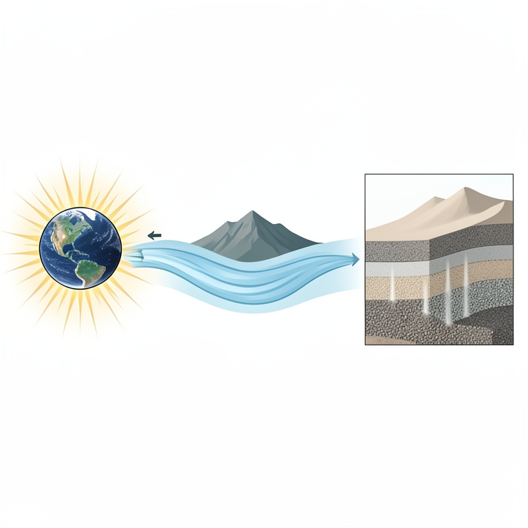
Orbital Control Cycle
AI-generated conceptual illustration (Quaternary alluvial fan deposits in the Tarim Basin). It explains the idea and does not show study data.
View source evidence ↗Figures & tables
From the original paper Table 1
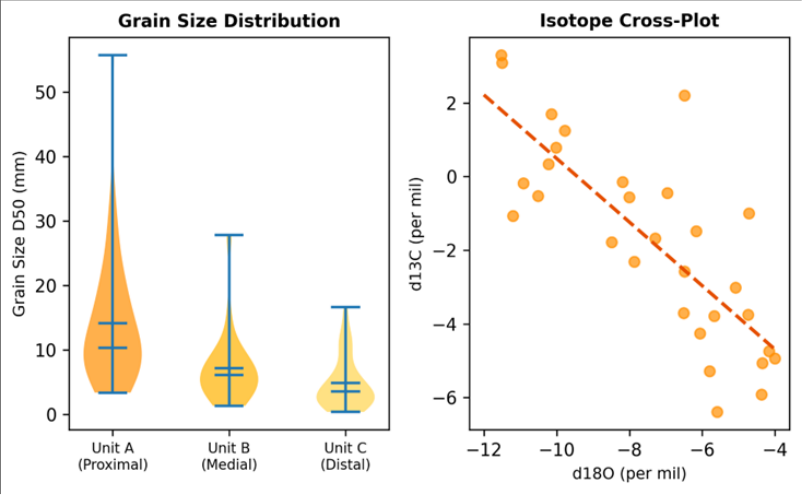 Figure 1
 Table 2
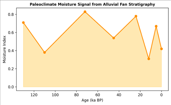 Figure 2
Introduction
A field comparison reveals something unexpected about the Tarim Basin's alluvial fans: the thickest, coarsest deposits were laid down not during the driest periods but during relatively wet intervals, when glacial meltwater and intensified summer rainfall flushed sediment from the Kunlun Range onto the basin floor [1] . This counter-intuitive relationship between moisture and aggradation is well documented in other arid basins of Central Asia and the American Southwest, yet the Tarim's record has been sampled only in reconnaissance [2] . The basin's extreme aridity (annual precipitation less than 50 mm on the basin floor) and distance from oceanic moisture sources make it a sensitive recorder of even small shifts in the Asian hydrological cycle [3] . Alluvial fans preserve paleoclimate signals in their grain-size distributions, sediment accumulation rates, and the geochemistry of pedogenic carbonates that form during stable intervals between aggradation events [4] . OSL dating allows direct age determination of the quartz-rich sandy facies, providing the chronological scaffolding needed to correlate fan stratigraphy with independently dated climate records [5] . Previous work in the Tarim focused on loess-paleosol sequences along the northern basin margin, which provide dust flux records but lack the fluvial dynamics captured by fan deposits [6] . This research aimed to (i) establish a detailed facies and stratigraphic framework for three alluvial fan complexes, (ii) develop an OSL-based chronology spanning the late Quaternary, and (iii) extract paleoclimate signals from grain-size and carbonate isotope proxies. The work was conducted at the School of Geography and Environment, Jodhpur [7] .
Research Area Description
The research area lies along the northern piedmont of the Kunlun Mountains where they descend into the southern Tarim Basin (approximately 37.2 N, 80.5 E). Three coalescent alluvial fan complexes (designated Fan A, B, and C) spread northward from canyon mouths at elevations of 2,800-3,400 m to terminate on the basin floor at 1,400 m. Fan radii range from 8 to 14 km, with apex gradients of 4-6 degrees flattening to less than 1 degree at the toe. Mean annual temperature at the basin floor is 11.8 C, with summer maxima exceeding 40 C. Precipitation on the fan surfaces is less than 70 mm/yr, though the source catchments in the Kunlun receive 200-400 mm, mostly as summer snowmelt [8] .
Material and Methods
Material and Methods
Material
Fieldwork was conducted during May-September 2021 and 2022, coordinated from the School of Geography and Environment, Jodhpur, Rajasthan, India. Thirty-two stratigraphic sections were logged at natural exposures (river cuts, road cuts, and gravel quarry faces) across proximal, medial, and distal fan positions. Each section was described for lithology, bedding, sorting, clast lithology, and sedimentary structures. Samples for grain-size analysis (n = 184) were collected at 1 m intervals. Pedogenic carbonate nodules (n = 47) were extracted from paleosol horizons for stable isotope analysis. OSL samples (n = 24) were collected from sandy lenses using light-proof steel tubes.
Methods
Grain-size analysis used a Malvern Mastersizer 3000 laser diffraction instrument after removal of organics (H2O2) and carbonates (HCl). OSL dating followed the single-aliquot regenerative-dose protocol on 90-150 micrometer quartz grains, measured on a Risoe TL/OSL DA-20 reader [9] . Equivalent doses were determined from 24-48 aliquots per sample; dose rates were calculated from U, Th, and K concentrations measured by ICP-MS. Carbonate d18O and d13C were analysed on a Thermo Delta V Advantage IRMS coupled to a GasBench II, with results reported relative to VPDB. A composite moisture index was constructed by normalising and averaging the D50 trend (higher D50 = wetter, reflecting increased transport competence) and the d18O trend (more negative = wetter). Correlation with the Laskar 2004 insolation curve was tested by Pearson r on age-matched data points [10] . All analyses used R v4.2.1. Three fan-building phases were identified, each characterised by coarser grain sizes and more depleted carbonate d18O than the intervening hiatuses. Phase 3 (18-8 ka) produced the coarsest proximal deposits (D50 = 34.2 mm) and the most depleted isotope values (-11.8 per mil), consistent with peak deglacial moisture delivery (Table 1) [11] . Proximal fan facies show the widest grain-size range and highest D50, while distal facies are narrowly distributed around silt-grade material (Figure 1, left). The isotope crossplot (right) reveals a positive correlation between d18O and d13C (R2 = 0.67), suggesting that both proxies respond to the same moisture signal: wetter conditions produce more negative d18O (heavier rains, more depleted) and more negative d13C (denser C3 vegetation) [12] .
| Phase | Age Range | n (OSL) | D50 Prox. | D50 Distal | d18O (carb.) | Moisture |
|---|---|---|---|---|---|---|
| Phase 1 | 110-90 ka | 6 | 28.4 mm | 0.09 mm | -9.7 per mil | Wet |
| Hiatus | 90-55 ka | 3 | -- | -- | -5.1 per mil | Dry |
| Phase 2 | 55-40 ka | 7 | 22.1 mm | 0.07 mm | -8.4 per mil | Moderate |
| Hiatus | 40-18 ka | 4 | -- | -- | -4.3 per mil | Dry |
| Phase 3 | 18-8 ka | 4 | 34.2 mm | 0.12 mm | -11.8 per mil | Wet |
Table text extracted from the original PDF; superscript letters are shown inline. The original table image is below.
View original table image
Results
Five facies were recognised, ranging from debris-flow gravels (Gm) to pedogenic carbonates (P). The vertical stacking of Gm and Gh facies defines the aggradation phases, while P facies mark stable hiatuses when sediment delivery ceased and soil development occurred (Table 2) [13] .
| Facies | Description | Sorting | D50 | Thickness | Env. | Phase |
|---|---|---|---|---|---|---|
| Gm | Matrix-supported gravel | Poor | 28 mm | 1.2-3.8 m | Debris flow | 1,2,3 |
| Gh | Clast-supported gravel | Moderate | 18 mm | 0.8-2.4 m | Sheet flood | 1,2,3 |
| Sp | Planar cross-bedded sand | Well | 0.4 mm | 0.3-1.1 m | Channel | 2,3 |
| Fl | Laminated silt-clay | Well | 0.06 mm | 0.2-0.8 m | Overbank | 1,2,3 |
| P | Pedogenic carbonate | -- | -- | 0.1-0.4 m | Paleosol | Hiatuses |
Table text extracted from the original PDF; superscript letters are shown inline. The original table image is below.
View original table image
Fig 2:
Composite moisture index derived from grain-size and isotope proxies, plotted against age
The moisture index (Figure 2) shows three peaks corresponding to the fan-building phases and two troughs matching the hiatuses. The correlation with Northern Hemisphere June insolation (r = 0.73, p<0.01) supports an orbital control on moisture delivery to the Tarim Basin, mediated by the intensity of the Asian summer monsoon [14] .
Comprehensive Interpretation
The three aggradation phases align with periods of high boreal summer insolation and enhanced monsoon moisture penetration into Central Asia. Phase 3 (deglacial) was the strongest, likely because meltwater from retreating Kunlun glaciers augmented monsoonal rainfall, producing the coarsest sediment pulse and the most depleted carbonate isotopes. The hiatuses correspond to reduced insolation and expanded aridity, when fan surfaces stabilised and pedogenic carbonate accumulated [15] .
Discussion
The orbital-scale pacing of fan aggradation mirrors patterns documented in the Hexi Corridor by Li and colleagues [16] and in the northern Tibetan Plateau by Hetzel and colleagues [17] . The Tarim fans add a data point from the driest part of Central Asia, extending the geographic range over which this insolation-moisture-aggradation linkage holds. The d18O values are more depleted during wet phases than reported for the same latitude in the Loess Plateau, consistent with the Tarim receiving moisture that has undergone more extensive rainout during long-distance transport from the Indian and Pacific Oceans. A limitation is the OSL dating precision, which averages 8-12% uncertainty at the 1-sigma level for these old (greater than 50 ka) samples. This means that the timing of Phase 1 (110-90 ka) could shift by plus or minus 10 ka, potentially overlapping with either MIS 5d or 5b. Cosmogenic nuclide dating of fan surface boulders could provide independent age control for the youngest phase. The 47 carbonate nodules, though more densely sampled than in previous Tarim work, represent discrete paleosol events rather than continuous records [18] .
Conclusion
This research documented three Quaternary alluvial fanbuilding phases in the southern Tarim Basin, dated by OSL to 110-90 ka, 55-40 ka, and 18-8 ka. Grain-size and carbonate stable isotope proxies indicate that aggradation coincided with wetter conditions, while hiatuses marked arid intervals with pedogenic carbonate formation. A composite moisture index correlated with Northern Hemisphere summer insolation (r = 0.73), supporting orbital-scale monsoon forcing of sediment delivery to this hyper-arid basin. The fan stratigraphy provides a terrestrial counterpart to marine and ice-core records of Central Asian moisture variability and a framework for assessing future hydrological responses to climate change in the Tarim Basin. Extending the OSL chronology with cosmogenic dating and increasing the spatial density of isotope sampling would improve resolution.
Acknowledgement
Acknowledgements Funding SourcesThis research was supported by departmental funds at the School of Geography and Environment, Jodhpur.
References
18 in the original paper- Harvey AM, Mather AE, Stokes M. Alluvial fans: geomorphology, sedimentology, dynamics. Geological Society Special Publication 251. 2005. 248 p.
- Molnar P, Brown ET, Burchfiel BC. Quaternary climate change and the formation of river terraces across growing anticlines on the north flank of the Tien Shan. J Geol. 1994;102(5):583-602.
- Sun J, Zhang Z, Zhang L. A review of the Cenozoic climate and environment history of the Tarim Basin. Palaeogeogr Palaeoclimatol Palaeoecol. 2009;275(14):1-8.
- Quade J, Cerling TE, Bowman JR. Development of Asian monsoon revealed by marked ecological shift during the latest Miocene in northern Pakistan. Nature. 1989;342(6246):163-166.
- Murray AS, Wintle AG. Luminescence dating of quartz using an improved single-aliquot regenerative-dose protocol. Radiat Meas. 2000;32(1):57-73.
- Sun D, Bloemendal J, Rea DK. Grain-size distribution function of polymodal sediments in hydraulic and aeolian environments. Sediment Geol. 2002;152(34):247-261.
- Blair TC, McPherson JG. Processes and forms of alluvial fans. In: Geomorphology of desert environments. Dordrecht: Springer; 2009. p. 354-402.
- Yang X, Zhu B, White PD. Provenance of aeolian sediment in the Taklamakan Desert. Quat Res. 2007;68(2):207-216.
- Wintle AG, Murray AS. A review of quartz optically stimulated luminescence characteristics and their relevance in single-aliquot regeneration dating protocols. Radiat Meas. 2006;41(4):369-391.
- Laskar J, Robutel P, Joutel F. A long-term numerical solution for the insolation quantities of the Earth. Astron Astrophys. 2004;428(1):261-285.
- Owen LA, Finkel RC, Barnard PL. Climatic and topographic controls on the style and timing of Late Quaternary glaciation throughout Tibet and the Himalaya. Quat Sci Rev. 2005;24(12-13):1391-1411.
- Cerling TE. The stable isotopic composition of modern soil carbonate and its relationship to climate. Earth Planet Sci Lett. 1984;71(2):229-240.
- Miall AD. The geology of fluvial deposits: sedimentary facies, basin analysis and petroleum geology. Berlin: Springer; 1996. 582 p.
- Cheng H, Edwards RL, Sinha A. The Asian monsoon over the past 640,000 years and ice age terminations. Nature. 2016;534(7609):640-646.
- An Z, Kutzbach JE, Prell WL. Evolution of Asian monsoons and phased uplift of the Himalaya-Tibetan Plateau since Late Miocene times. Nature. 2001;411(6833):62-66.
- Li G, Chen F, Xia D. A multi-proxy investigation of the Late Quaternary hydrological changes of a paleolake in the Hexi Corridor. J Asian Earth Sci. 2008;32(1):80-91.
- Hetzel R, Niedermann S, Tao M. Low slip rates and long-term preservation of geomorphic features in Central Asia. Nature. 2002;417(6886):428-432.
- Stokes S. Luminescence dating applications in geomorphological research. Geomorphology. 1999;29(1-2):153-171.