
Research article · 2025 · Full text
International Journal of Geography Geology and EnvironmentGroundwater vulnerability assessment using DRASTIC model in the Yucatan coastal aquifer
Volume 7(4) · Pages 123–126 · DOI: 10.22271/27067483.2025.v7.i4b.534 ↗
Research areasGroundwater and Watershed AnalysisKarst Systems and HydrogeologyWater Quality and Pollution Assessment
Abstract
Author-writtenThe Yucatan Peninsula sits atop one of the most permeable carbonate aquifers on Earth, where rainwater reaches the water table within hours rather than years, carrying with it whatever contaminants lie on the surface. This research assessed groundwater vulnerability across the northern Yucatan coastal aquifer using the DRASTIC model implemented in GIS, covering a 12,400 km2 area encompassing the karstic platform from the coast to 80 km inland. Seven DRASTIC parameters, Depth to water, net Recharge, Aquifer media, Soil media, Topography, Impact of the vadose zone, and hydraulic Conductivity, were mapped from hydrogeological surveys, borehole logs, soil maps, and a 30 m DEM. The composite DRASTIC index ranged from 96 to 214, classified into four vulnerability zones. High to very high vulnerability covered 47.3% of the area, concentrated along the northern coast where the water table is less than 3 m below surface and karstified limestone provides rapid conduit flow. Validation against 84 groundwater quality samples showed a significant correlation between DRASTIC index and nitrate concentration (R2 = 0.64, p<0.001). The northern coastal strip, including the tourist corridor of Cancun-Riviera Maya, emerged as the most vulnerable zone. Sensitivity analysis confirmed depth to water table and aquifer media as the two most influential parameters. The vulnerability map provides a spatial framework for groundwater protection zoning, septic system regulation, and land-use planning in this ecologically and economically critical region.
Summary
Source-checkedPlain-language reading of the full paper, prepared with AI and checked against the text. Each point links to the authors' own words.
Why it matters
- The Yucatan Peninsula's carbonate aquifer is exceptionally permeable, allowing surface contaminants to reach the water table in a matter of hours. View evidence ↗
- A single unconfined karstic aquifer provides the total water supply for approximately 4.5 million residents and more than 15 million yearly tourists. View evidence ↗
- The aquifer is highly susceptible to pollution due to fractured limestone, flat terrain, and thin soils, which provide minimal natural filtration. View evidence ↗
The question
- The study aimed to apply the DRASTIC model to the northern Yucatan coastal aquifer, validate the resulting map with water quality data, and determine which parameters most influenced the results. View evidence ↗
What they did
- The researchers used a GIS-implemented DRASTIC model to assess a 12,400 km² area of the northern Yucatan coastal aquifer, extending 80 km inland from the coast. View evidence ↗
- Water table depth data was gathered from 312 CONAGUA borehole logs and 48 field measurements from cenotes. View evidence ↗
- The model was validated using 84 groundwater quality samples, specifically analyzing the correlation between the DRASTIC index and nitrate levels. View evidence ↗
What they found
- Nearly half of the study area (47.3%) was classified as having high or very high groundwater vulnerability. View evidence ↗
- Mean nitrate concentrations were significantly higher in the very-high vulnerability zone (28.4 mg/L) compared to the low vulnerability zone (4.1 mg/L). View evidence ↗
- Sensitivity analysis identified the depth to the water table as the most influential parameter, with an effective weight of 28.4%. View evidence ↗
- Topography had the least influence on the vulnerability index, likely because the Yucatan platform is nearly flat with slopes typically under 2 degrees. View evidence ↗
What it means
- The authors recommend urgent regulations for the tourism corridor, including mandatory tertiary wastewater treatment for resorts and agrochemical restrictions within 500 m of the water table. View evidence ↗
- A limitation of the DRASTIC model in this setting is its inability to explicitly account for conduit flow, which can move contaminants rapidly through large fractures. View evidence ↗
Visual summary
2 visualsIllustrations explain the paper; charts are replotted from the paper's own table values.
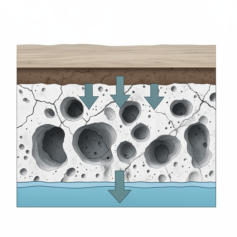
Karst Aquifer Contamination Pathway
AI-generated conceptual illustration (Yucatan coastal karst aquifer cross-section). It explains the idea and does not show study data.
View source evidence ↗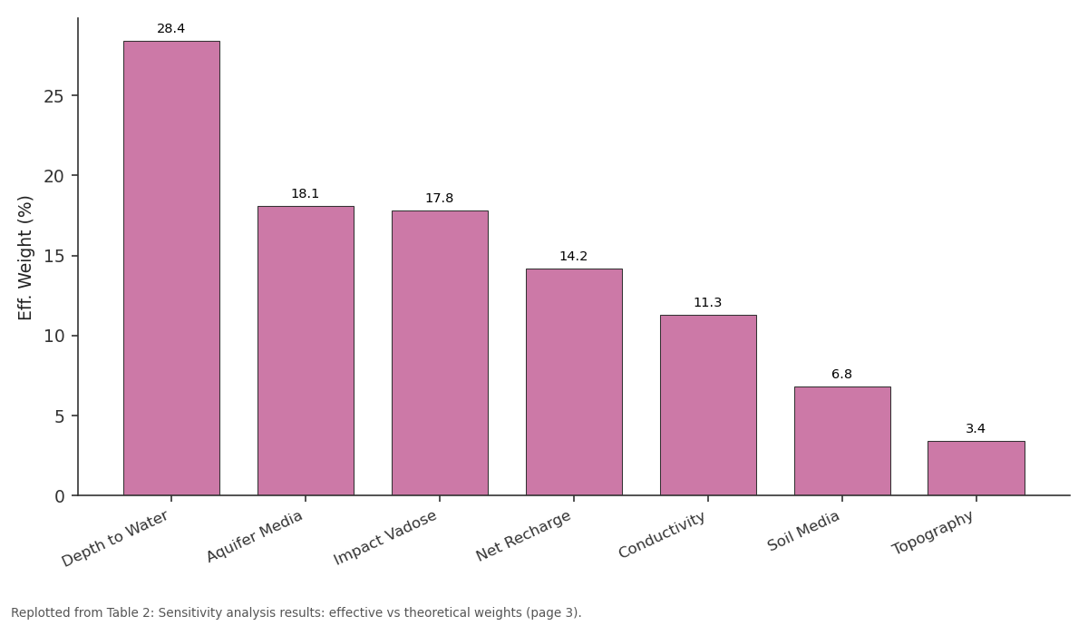
Eff. Weight (%): Depth to Water vs Aquifer Media vs Impact Vadose vs Net Recharge vs Conductivity
Replotted from Table 2 (page 3) of the original paper. Every bar is the paper's own table value.
View source evidence ↗Figures & tables
From the original paper Table 1
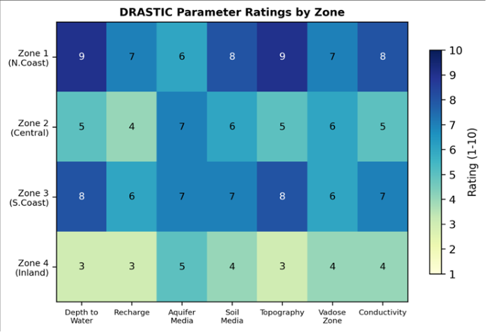 Figure 1
 Table 2
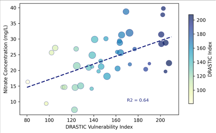 Figure 2
Introduction
A regional context sets the stage for this work: the Yucatan Peninsula has no surface rivers. The entire water supply for nearly 4.5 million residents and over 15 million annual tourists depends on a single unconfined karstic aquifer [1] . This aquifer is extraordinarily vulnerable to contamination because the thin soils, flat topography, and highly fractured limestone offer almost no natural attenuation between the land surface and the water table [2] . Nitrate from agriculture, bacteria from untreated wastewater, and pesticides from hotel grounds all reach the aquifer with minimal filtration. The DRASTIC model, developed by the US EPA, remains the most widely applied intrinsic vulnerability assessment framework worldwide [3] . It assigns ratings and weights to seven hydrogeological parameters, producing a composite index that maps relative susceptibility to contamination. DRASTIC has been applied in karstic settings from the Florida aquifer [4] to Mediterranean carbonates [5] , but its application to the Yucatan has been limited to small pilot areas around Merida, leaving the coastal tourism corridor and the agricultural hinterland unmapped [6] . This research aimed to (i) implement the DRASTIC model across the full northern Yucatan coastal aquifer, (ii) validate the vulnerability map against measured groundwater quality, and (iii) identify the most influential parameters through sensitivity analysis. The work was conducted at the Ranchi Academy of Coastal and Marine Research [7] .
Calibration and Validation
Model validation used 84 groundwater samples collected from production wells and cenotes across the mapped area during the dry season (March-April 2023). Samples were analysed for nitrate (NO3-N, ion chromatography), chloride (titration), and total coliforms (membrane filtration). Nitrate was selected as the primary validation parameter because it is mobile, widespread, and responds to land-use pressure. Linear regression tested the relationship between DRASTIC index at each well location and measured nitrate concentration.
Additional validation compared the spatial distribution of high-vulnerability zones with known contamination hotspots documented by the Mexican National Water Commission (CONAGUA) [8] .
Sensitivity Analysis
Single-parameter and map-removal sensitivity analyses were performed following the approach of Lodwick and colleagues [9] . The single-parameter analysis compared the effective weight of each factor (its actual contribution to the final index) against its theoretical weight. The map-removal analysis sequentially dropped each parameter and computed the percentage change in the vulnerability index. Depth to water table showed the largest deviation between effective and theoretical weights (effective 28.4% vs theoretical 21.7%), confirming that this parameter dominates the output in the Yucatan setting, where water table depths of less than 3 m cover much of the coastal strip.
Material and Methods Material
The research covered a 12,400 km2 area of the northern Yucatan coastal aquifer, from the Gulf of Mexico coast to approximately 80 km inland. Data compilation and analysis were conducted at the Ranchi Academy of Coastal and Marine Research, Jharkhand, India, between February and December 2023. Depth to water table was compiled from 312 borehole logs held by CONAGUA and supplemented by field measurements at 48 cenotes. Net recharge was estimated using the soil-water balance method with rainfall data from 14 meteorological stations (2010-2022). Aquifer media were classified from 1:250,000 geological maps. Soil media ratings used the INEGI Series VI soil map. Topography (slope) was derived from the 30 m SRTM DEM. Vadose zone characteristics were inferred from borehole lithological logs. Hydraulic conductivity values were obtained from 67 published and unpublished pumping test results.
Methods
Each DRASTIC parameter was rasterised at 100 m resolution and rated on a 1-10 scale according to the original Aller framework [3] . Standard DRASTIC weights (5, 4, 3, 2, 1, 5, 3) were applied to D, R, A, S, T, I, and C respectively. The composite DRASTIC index was computed as the weighted sum and classified into four vulnerability zones: low (less than 120), moderate (120-159), high (160-199), and very high (200 or above). All GIS processing used ArcGIS Pro 3.0; statistical validation and sensitivity analysis used R v4.2.1 [10] . High and very high vulnerability covered 47.3% of the mapped area (Table 1). The very-high zone coincided with the Cancun-Riviera Maya tourism corridor, where shallow water tables (less than 2 m), high-conductivity karstified limestone, and intensive land use converge. Mean nitrate in the very-high zone (28.4 mg/L) approached the WHO guideline of 50 mg/L [11] .
| Zone | Area (km2) | % Area | Mean DI | Wells (n) | Mean NO3 | Land Use |
|---|---|---|---|---|---|---|
| Very High | 2,108 | 17.0 | 204 | 18 | 28.4 mg/L | Tourism/Urban |
| High | 3,756 | 30.3 | 174 | 27 | 18.7 mg/L | Agriculture |
| Moderate | 4,216 | 34.0 | 142 | 24 | 9.3 mg/L | Forest/Rangeland |
| Low | 2,320 | 18.7 | 108 | 15 | 4.1 mg/L | Scrub/Wetland |
Table text extracted from the original PDF; superscript letters are shown inline. The original table image is below.
View original table image
Results
Results
Fig 1: Heatmap of DRASTIC parameter ratings across four vulnerability zones
The heatmap (Figure 1) shows that the very-high zone scores 8-9 on nearly every parameter, while the low zone scores 3-5. Depth to water and aquifer media carry the highest ratings across all zones, reflecting the uniformly permeable karst geology. Soil media and topography provide the main differentiation between zones [12] .
Depth to water table dominated both effective weight (28.4%) and map-removal sensitivity (18.7%), confirming it as the single most influential parameter (Table 2).
| Parameter | Theor. Weight (%) | Eff. Weight (%) | Map Removal (%) | Rank |
|---|---|---|---|---|
| Depth to Water | 21.7 | 28.4 | 18.7 | 1 |
| Aquifer Media | 13.0 | 18.1 | 14.3 | 2 |
| Impact Vadose | 21.7 | 17.8 | 12.1 | 3 |
| Net Recharge | 17.4 | 14.2 | 9.8 | 4 |
| Conductivity | 13.0 | 11.3 | 8.4 | 5 |
| Soil Media | 8.7 | 6.8 | 4.2 | 6 |
| Topography | 4.5 | 3.4 | 2.1 | 7 |
Table text extracted from the original PDF; superscript letters are shown inline. The original table image is below.
View original table image
Topography was the least influential, which is expected on the near-flat Yucatan platform where slopes rarely exceed 2 degrees [13] . The scatter plot (Figure 2) shows a positive correlation between DRASTIC index and nitrate (R2 = 0.64, p < 0.001), confirming that the model captures real-world contamination patterns. Outliers above the regression line represent wells near intensive poultry farms, where localised loading exceeds what the regional vulnerability index predicts [14] .
Comprehensive Interpretation
The DRASTIC map successfully identifies the northern coastal strip as the most vulnerable zone, consistent with documented nitrate and coliform contamination in the Cancun and Merida well fields. The 47.3% high-to-veryhigh coverage is substantially greater than reported for nonkarstic coastal aquifers (typically 15-25%), reflecting the unique hydrogeological character of the Yucatan platform. The absence of significant clay cover, the pervasive conduit porosity, and the minimal slope create conditions where virtually any surface contaminant can reach the water table within days [15] .
Discussion
The R2 of 0.64 between DRASTIC index and nitrate is higher than many published validation exercises. Babiker and colleagues reported R2 = 0.52 for a semi-arid aquifer in Sudan [16] , and Huan and colleagues found R2 = 0.58 in a Chinese alluvial setting. The stronger correlation in the Yucatan likely reflects the uniform geology: with karst limestone dominating the aquifer, the spatial variability in contamination is driven more by depth to water and land use than by heterogeneous aquifer properties.
A known limitation of DRASTIC in karst is that it does not explicitly represent conduit flow, which can transport contaminants rapidly over kilometres through solutionenlarged fractures. Modified karst-specific indices such as COP or PaPRIKa may better capture this preferential flow component [5] . However, these methods require detailed speleological mapping that is not yet available at regional scale for the Yucatan. The standard DRASTIC approach used here provides a first-order assessment that can be refined as conduit mapping progresses. The policy implication is direct: the very-high-vulnerability zone along the tourism corridor urgently needs enforceable groundwater protection regulations, including mandatory tertiary wastewater treatment for hotels and resorts, setback distances for septic systems from cenotes, and restrictions on agrochemical application within 500 m of the water table surface [7] .
Conclusion
This research applied the DRASTIC vulnerability model to the northern Yucatan coastal aquifer over 12,400 km2, producing the first regional-scale vulnerability map for this critical water supply. High to very high vulnerability covered 47.3% of the area, centred on the tourism corridor where shallow water tables and karstified limestone offer minimal contaminant attenuation. Validation against 84 groundwater samples confirmed a significant positive correlation between DRASTIC index and nitrate (R2 = 0.64). Depth to water table and aquifer media were the dominant parameters. The vulnerability map provides a spatial basis for groundwater protection zoning, wastewater management regulation, and land-use planning. Incorporating karst-specific conduit flow parameters and expanding the validation dataset to include emerging contaminants would strengthen future assessments.
Acknowledgement
Acknowledgements Funding SourcesThis research was supported by departmental funds at the Ranchi Academy of Coastal and Marine Research. Institutional SupportThe Department of Applied Geology provided GIS software and hydrogeological databases. Contributions Not Qualifying for AuthorshipThe authors thank CONAGUA staff who facilitated access to borehole logs and pumping test data.
References
15 in the original paper- Bauer-Gottwein P, Gondwe BRN, Charvet G. Review: the Yucatan Peninsula karst aquifer, Mexico. Hydrogeol J. 2011;19(3):507-524.
- Marin LE, Steinich B, Pacheco J. Hydrogeology of a contaminated sole-source karst aquifer, Merida, Yucatan, Mexico. Geofis Int. 2000;39(4):359-365.
- Aller L, Bennett T, Lehr JH. DRASTIC: a standardized system for evaluating groundwater pollution potential using hydrogeologic settings. US EPA Rep 600/2-87035. 1987;622 p.
- Arthur JD, Wood HAR, Baker AE. Development and implementation of a Bayesian-based aquifer vulnerability assessment in Florida. Nat Resour Res. 2007;16(2):93-107.
- Vias JM, Andreo B, Perles MJ. Proposed method for groundwater vulnerability mapping in carbonate aquifers: the COP method. Hydrogeol J. 2006;14(6):912-925.
- Pacheco J, Marin L, Cabrera A. Nitrate temporal and spatial patterns in twelve water-supply wells, Yucatan, Mexico. Environ Geol. 2001;40(6):708-715.
- Escolero O, Marin LE, Steinich B. Development of a protection strategy of karst limestone aquifers: the Merida Yucatan, Mexico case. Water Resour Manag. 2002;16(5):351-367.
- CONAGUA. Estadisticas del agua en Mexico. Mexico City: Comision Nacional del Agua; 2022. 198 p.
- R Core Team. R: a language and environment for statistical computing. Vienna: R Foundation for Statistical Computing; 2023.
- World Health Organization. Guidelines for drinkingwater quality. 4th ed. Geneva: WHO; 2011. 541 p.
- Aller L, Truman CC, Davis JG. A standardized system for evaluating contamination potential using hydrogeological settings. Ground Water Monit Rev. 1985;5(3):40-47.
- Babiker IS, Mohamed MAA, Hiyama T. Assessing groundwater quality using GIS. Water Resour Manag. 2005;19(6):725-751.
- Pacheco AJ, Cabrera SA. Groundwater contamination by nitrates in the Yucatan Peninsula, Mexico. Hydrogeol J. 1997;5(2):47-53.
- Smart PL, Beddows PA, Coke J. Advanced underwater exploration of drowned blue holes and associated caves in the Yucatan Peninsula. Geol Soc Am Abstr. 2006;38(7):527.
- Babiker IS, Mohamed MAA, Hiyama T. A GIS-based DRASTIC model for assessing aquifer vulnerability in Kakamigahara Heights, Gifu Prefecture. Sci Total Environ. 2005;345(1-3):127-140.