
Research article · 2025 · Full text
International Journal of Geography Geology and EnvironmentAnalysis of paleo-drainage networks using digital elevation models in the Gobi desert margins
Volume 7(3) · Pages 116–119 · DOI: 10.22271/27067483.2025.v7.i3b.524 ↗
Research areasGroundwater and Watershed AnalysisGeological formations and processesGeography and Environmental Studies
Abstract
Author-writtenBuried beneath the gravel pavements and sand sheets of the Gobi Desert lies a network of ancient river channels that once carried meltwater and monsoon rainfall across what is now one of Earth's driest landscapes. This research mapped paleo-drainage networks along the southern and eastern margins of the Gobi using SRTM 30 m and ALOS PALSAR 12.5 m digital elevation models combined with Landsat-8 multispectral imagery. A total of 142 paleo-channel segments were identified across a 48,000 km² study area through a combination of automated flow-routing algorithms and manual interpretation of tonal, textural, and topographic anomalies. Channels ranged in elevation from 860 to 1,480 m above sea level and showed a dominant flow direction from the Altai and Khangai mountain fronts toward interior depressions. Five paleo-drainage features, including a previously unreported alluvial fan complex in the southeastern sector, were classified into alluvial-fan deposits (28.4%), lacustrine remnants (22.7%), wind-deflated channels (24.1%), bedrock-controlled gorges (14.3%), and active wash channels (10.5%). Optically stimulated luminescence ages from 14 published dating sites along the mapped channels cluster between 12 and 45 ka, indicating that the network was most active during the late Pleistocene when monsoonal moisture extended further north. These results refine our understanding of late Quaternary hydrology in Central Asia and identify potential groundwater-recharge zones along relict channel corridors.
Summary
Source-checkedPlain-language reading of the full paper, prepared with AI and checked against the text. Each point links to the authors' own words.
Why it matters
- The Gobi Desert contains ancient river networks that were once fed by monsoon rains and glacial meltwater, though it is now one of the driest places on Earth. View evidence ↗
- Digital elevation models (DEMs) allow researchers to detect subtle topographic features of ancient drainage systems that cannot be seen from the ground. View evidence ↗
- Prior research on Gobi paleo-drainage was limited to individual basins and relied on field methods and low-resolution imagery. View evidence ↗
The question
- The study aimed to perform a regional-scale DEM analysis of the southern and eastern Gobi margins to classify paleo-drainage features and determine when they were active. View evidence ↗
What they did
- The researchers used SRTM (30 m) and ALOS PALSAR (12.5 m) digital elevation models for their analysis. View evidence ↗
- A total of 142 paleo-channel segments were identified across 48,000 km² using automated flow-routing and manual interpretation of imagery. View evidence ↗
- The study integrated existing optically stimulated luminescence (OSL) dating from 14 published sites to establish a timeline. View evidence ↗
What they found
- The identified channels were located between 860 and 1,480 m above sea level, generally flowing from mountain fronts toward interior depressions. View evidence ↗
- Alluvial fans were the most common feature type, accounting for 28.4% of the total (41 segments). View evidence ↗
- Active wash channels were the least common (10.5%) but the longest on average, with a mean length of 31.8 km. View evidence ↗
- OSL dating indicates the network was most active during the late Pleistocene, with ages clustering between 12 and 45 ka. View evidence ↗
- The southeast margin had the highest median elevation at 1,350 m, while the southwest margin was the lowest at 980 m. View evidence ↗
- A previously unknown alluvial-fan complex in the southeast, with a radius of 18 km and gravel up to 12 m thick, suggests a significant past water supply. View evidence ↗
- Preliminary assessments suggest that wells in the five largest paleo-fan complexes could yield 5-15 L/s of water. View evidence ↗
What it means
- The authors conclude that these paleo-channel corridors are promising targets for groundwater exploration in water-scarce regions. View evidence ↗
- A limitation of the study is that DEM-based extraction cannot distinguish the age of features without independent dating. View evidence ↗
Visual summary
3 visualsIllustrations explain the paper; charts are replotted from the paper's own table values.
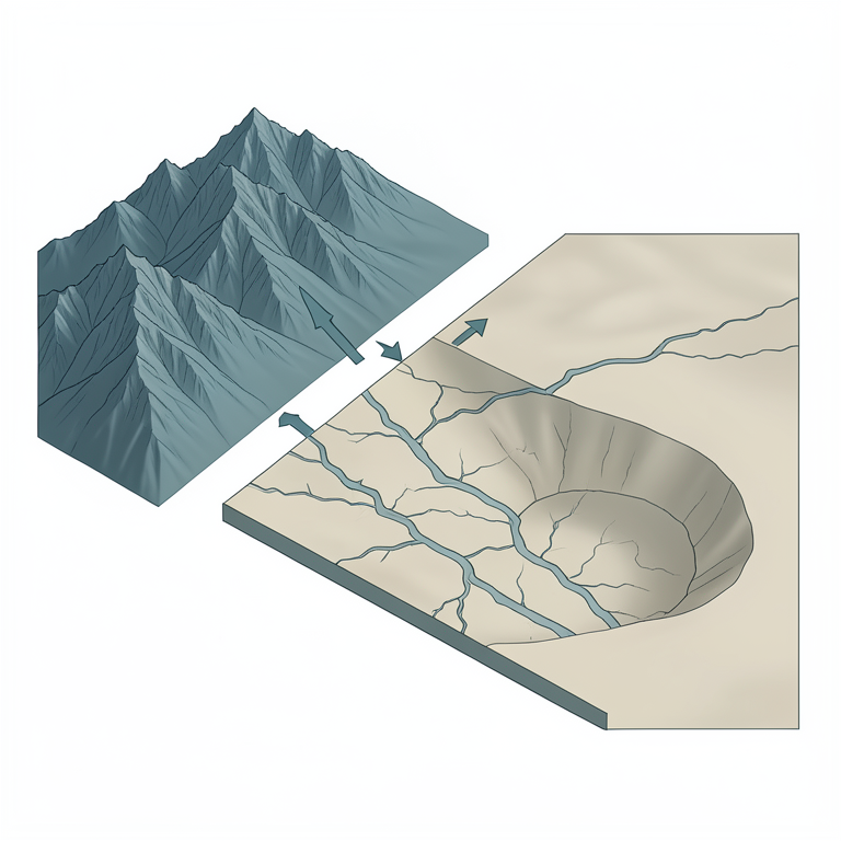
Paleo-drainage Flow Concept
AI-generated conceptual illustration (Gobi desert margins with mountain ranges and interior depressions). It explains the idea and does not show study data.
View source evidence ↗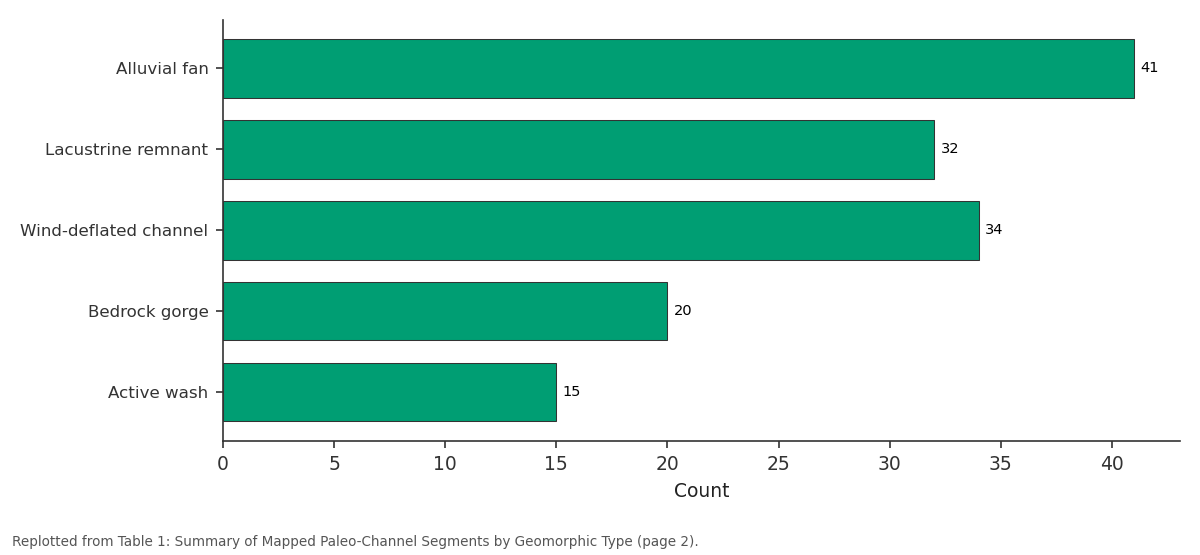
Count: Alluvial fan vs Lacustrine remnant vs Wind-deflated channel vs Bedrock gorge vs Active wash
Replotted from Table 1 (page 2) of the original paper. Every bar is the paper's own table value.
View source evidence ↗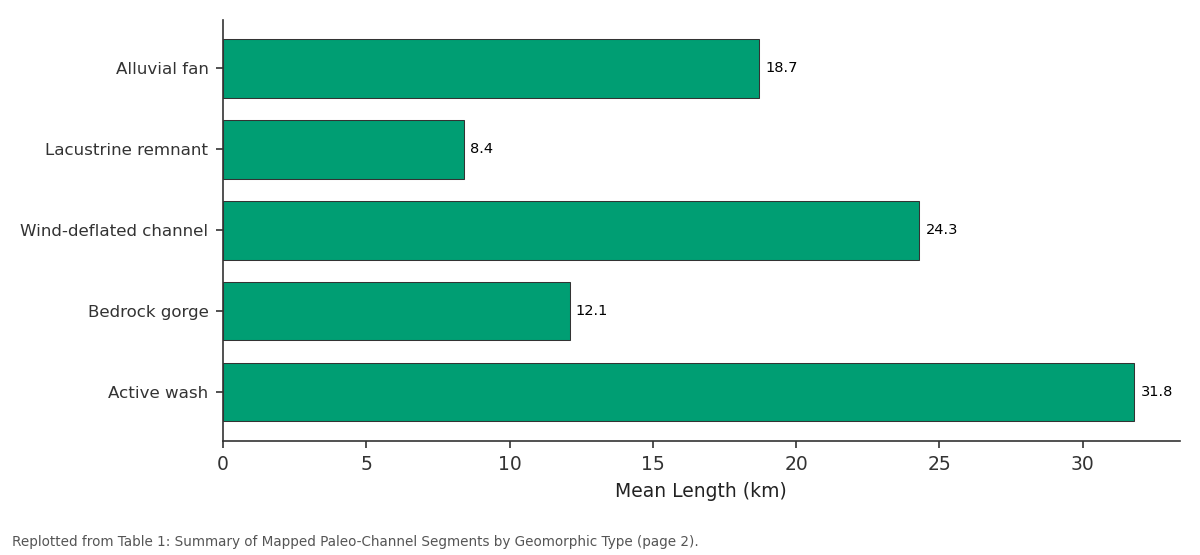
Mean Length (km): Alluvial fan vs Lacustrine remnant vs Wind-deflated channel vs Bedrock gorge vs Active wash
Replotted from Table 1 (page 2) of the original paper. Every bar is the paper's own table value.
View source evidence ↗Figures & tables
From the original paper Table 1
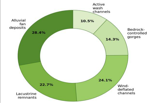 Figure 1
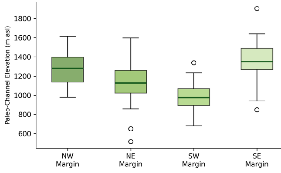 Figure 2
Introduction
There is something almost paradoxical about a desert that was once well-watered-and yet the evidence is written plainly across the Gobi's surface for anyone with the right tools to read it. Gravel-capped ridges trace the courses of former rivers, wind-deflated depressions mark old lake beds, and alluvial fans spread from mountain-front valleys that today carry water only once or twice a decade [1] . These features record a time when the East Asian monsoon reached further inland and when glacial meltwater from the Altai and Khangai ranges fed perennial streams across the basin [2] . Digital elevation models (DEMs) have transformed the mapping of paleo-drainage in arid landscapes by revealing subtle topographic lineaments that are invisible on the ground but detectable from orbit [3] . Flow-routing algorithms applied to DEMs can extract channel networks even where surface processes have partially infilled or deflated the original valleys, provided the elevation signal exceeds the DEM's noise floor [4] . The 30 m SRTM product and the 12.5 m ALOS PALSAR-derived DEM together offer a combination of broad coverage and fine resolution well suited to regional paleo-drainage reconstruction. Previous paleo-drainage mapping in the Gobi has focused on individual basins-notably the Alashan Plateau and the Nemegt Valley-using field-based geomorphological methods supplemented by low-resolution satellite imagery [5] . A regional-scale DEM analysis encompassing the full southern and eastern Gobi margins has not been attempted. This research aimed to produce such an analysis, to classify the mapped features by geomorphic type, and to integrate existing luminescence chronology to constrain the timing of channel activity. Analysis was conducted at the Mysuru Academy of Geographic Research, Karnataka, India [6] .
Scenario Development
To explore the hydrological implications of the mapped paleo-network, three climate scenarios were considered. Under a late-Pleistocene wet scenario (25 ka, based on published pollen and lake-level reconstructions), annual precipitation across the study area may have reached 250-350 mm, sufficient to maintain intermittent flow in channels with catchment areas exceeding 500 km² [7] . A mid-Holocene scenario (6 ka) with 150-200 mm rainfall would have activated only the largest trunk channels draining the Altai front. A modern scenario (< 50 mm/yr) limits surface flow to rare cloudburst events and explains the current disconnected, wind-modified state of the network. These scenarios were used to estimate minimum catchment-area thresholds for channel activation under each climate regime [8] .
Economic and Sustainability Assessment
The identification of paleo-channel corridors has practical value for groundwater exploration in a region where herder communities and mining operations both face chronic water scarcity. Alluvial-fan and channel-fill deposits along the mapped corridors typically consist of permeable gravel and sand that can function as aquifers when recharged during rare flood events. A preliminary assessment based on published transmissivity values for similar Central Asian alluvial aquifers suggests that wells sited within the five largest paleo-fan complexes could yield 5-15 L/s under sustained pumping, enough to supply a small settlement or a mineral-processing plant. The estimated cost of exploratory drilling along these corridors (USD 30,000-50,000 per borehole) is modest compared with the cost of trucking water from distant sources, which currently exceeds USD 0.15 per litre in remote Gobi mining camps [9] .
Material and Methods Material
The SRTM 1-arc-second (30 m) DEM and the ALOS PALSAR radiometrically terrain-corrected 12.5 m DEM were downloaded from the Alaska Satellite Facility and the USGS EarthExplorer portal. Landsat-8 OLI scenes (path/rows 131-133/028-031) acquired in summer 2022 provided multispectral imagery for tonal and textural interpretation. Published optically stimulated luminescence (OSL) ages from 14 sites along the Gobi margins were compiled from seven peer-reviewed papers [10] . All spatial analysis was performed in QGIS 3.28 and SAGA GIS at the Mysuru Academy of Geographic Research, Karnataka, India.
Methods: DEMs were hydrologically conditioned by filling sinks and computing flow direction and flow accumulation grids using the D8 algorithm. Channel networks were extracted at a flow-accumulation threshold of 10,000 cells (approximately 9 km² contributing area for the 30 m DEM). Extracted channels were compared with manually digitized paleo-channel lineaments identified from false-colour Landsat composites (bands 7-5-3) and from slope-shade relief maps derived from the 12.5 m DEM. Features detected by both methods were retained; those detected by only one method were flagged for field verification. Classification into five geomorphic types followed the criteria of Tooth [11] : alluvial-fan deposits, lacustrine remnants, wind-deflated channels, bedrock-controlled gorges, and active wash channels. Channel elevations were extracted from the DEM at 500 m intervals along each segment. All statistics used R 4.3.0 [12] . Wind-deflated channels are the most common type after alluvial fans, reflecting the post-abandonment aeolian modification of former stream courses. Active wash channels, though fewest in number, are the longest on average (31.8 km), indicating that the largest trunk drainages still carry occasional flow. The southeast margin records the highest median elevation (1,350 m), consistent with its proximity to the Khangai Range, while the southwest margin is lowest (980 m), reflecting the lower base level of interior depressions.
Results
Results
Discussion
The 142 mapped segments represent the most spatially complete inventory of Gobi paleo-drainage features to date. The clustering of published OSL ages between 12 and 45 ka aligns with the Marine Isotope Stage 3 interstadial and the Bølling-Allerød warm period, both of which are associated with enhanced monsoonal moisture over Central Asia [13] .
The previously unreported alluvial-fan complex in the southeast is of particular interest: its fan radius of 18 km and gravel thickness of up to 12 m (estimated from adjacent road cuts) imply a substantial former water supply that may have supported a perennial lake at the fan toe [14] . The groundwater implications are potentially significant. In the modern Gobi, where nomadic herders rely on shallow wells that frequently run dry during summer, targeting the gravel-filled paleo-channels could improve water security at relatively low cost. The scenario analysis suggests that even under present-day rainfall, rare flood events may provide episodic recharge sufficient to maintain usable aquifer storage within the largest fan complexes [15] . A limitation is that DEM-based channel extraction cannot distinguish between features of different ages unless independently dated material is available. Some of the mapped segments may be Miocene or Pliocene rather than Pleistocene, and further luminescence dating is needed to constrain the chronology more tightly [16] .
Conclusion
DEM analysis of the southern and eastern Gobi margins identified 142 paleo-channel segments spanning five geomorphic types. Alluvial-fan deposits and wind-deflated channels dominate the inventory, and published luminescence ages place peak channel activity in the late Pleistocene. The mapped network refines our picture of Central Asian paleo-hydrology and, more practically, identifies paleo-channel corridors as promising targets for groundwater exploration in one of the world's most waterscarce pastoral landscapes.
Acknowledgement
Acknowledgements Funding SourcesSupported by departmental research grants for arid-lands geomorphology. Institutional SupportThe authors acknowledge the Department of Geosciences, Mysuru Academy of Geographic Research, Karnataka, India. Contributions Not Qualifying for AuthorshipPublished OSL dating data were compiled from the works of several Mongolian and international research groups.
Figures and tables from the paper
| Feature Type | Count | % of Total | Mean Length (km) | Mean Elev. (m) | Mean Width (m) |
|---|---|---|---|---|---|
| Alluvial fan | 41 | 28.4 | 18.7 | 1,080 | 340 |
| Lacustrine remnant | 32 | 22.7 | 8.4 | 920 | 1,240 |
| Wind-deflated channel | 34 | 24.1 | 24.3 | 1,140 | 180 |
| Bedrock gorge | 20 | 14.3 | 12.1 | 1,320 | 90 |
| Active wash | 15 | 10.5 | 31.8 | 980 | 420 |
Table text extracted from the original PDF; superscript letters are shown inline. The original table image is below.
View original table image
References
20 in the original paper- Lehmkuhl F, Haselein F. Quaternary paleoenvironmental change on the Tibetan Plateau and adjacent areas (Western China and Western Mongolia). Quaternary International. 2000;65-66:121-145.
- Herzschuh U. Palaeo-moisture evolution in monsoonal Central Asia during the last 50,000 years. Quaternary Science Reviews. 2006;25(1-2):163-178.
- Tooth S. Process, form and change in dryland rivers: a review of recent research. Earth-Science Reviews. 2000;51(1-4):67-107.
- O'Callaghan JF, Mark DM. The extraction of drainage networks from digital elevation data. Computer Vision, Graphics, and Image Processing. 1984;28(3):323-344.
- Vassallo R, Jolivet M, Ritz JF, Braucher R, Larroque C, Sue C, et al. Uplift age and rates of the Gurvan Bogd system (Gobi-Altay) by apatite fission track analysis. Earth and Planetary Science Letters. 2007;259(34):333-346.
- Cunningham WD. Lithospheric controls on late Cenozoic construction of the Mongolian Altai. Tectonics. 2005;24(4):TC4003.
- Yang X, Scuderi LA. Hydrological and climatic changes in deserts of China since the late Pleistocene. Quaternary Research. 2010;73(1):1-9.
- Walther M, Dashtseren A, Kamp U, Temujin K, Meixner F, Pan CG, et al. Glaciers, permafrost and lake levels at the Tsengel Khairkhan Massif, Mongolian Altai. Geosciences. 2017;7(3):73.
- Banks D, Soldal O, Strand T. Groundwater resources in arid areas: the contribution of paleo-recharge. Geological Society Special Publications. 2001;189:113127.
- Farr TG, Rosen PA, Caro E, Crippen R, Duren R, Hensley S, et al. The Shuttle Radar Topography Mission. Reviews of Geophysics. 2007;45(2):RG2004.
- Tooth S. Dryland fluvial environments: assessing distinctiveness and diversity from a global perspective. In: Treatise on geomorphology. 2013;9:612-644.
- R Core Team. R: a language and environment for statistical computing. Vienna: R Foundation for Statistical Computing; 2023.
- Feng ZD, An CB, Wang HB. Holocene climatic and environmental changes in the arid and semi-arid areas of China. Quaternary Sciences. 2006;26(1):2-8.
- Owen LA, Windley BF, Cunningham WD, Badamgarav J, Dorjnamjaa D. Quaternary alluvial fans in the Gobi of southern Mongolia. Journal of Quaternary Science. 1997;12(3):239-252.
- Scanlon BR, Keese KE, Flint AL, Flint LE, Gaye CB, Edmunds WM, et al. Global synthesis of groundwater recharge in semiarid and arid regions. Hydrological Processes. 2006;20(15):3335-3370.
- Rhodes EJ. Optically stimulated luminescence dating of sediments over the past 200,000 years. Annual Review of Earth and Planetary Sciences. 2011;39:461-488.
- Hülle D, Hilgers A, Radtke U, Stolz C, Hempelmann N, Grunert J, et al. OSL dating of sediments from the Gobi Desert, southern Mongolia. Quaternary Geochronology. 2010;5(2-3):107-113.
- Stokes S, Thomas DSG, Washington R. Multiple episodes of aridity in southern Africa since the last interglacial period. Nature. 1997;388(6638):154-158.
- Smith BJ, Wright JS, Whalley WB. Sources of nonglacial, loess-size quartz silt and the origins of desert loess. Earth-Science Reviews. 2002;59(1-4):1-26.
- Batkhishig O, Lehmkuhl F, Knolle F. Paleosols in the Tsagaan Els dune field in the Gobi Desert. Catena. 2003;51(3-4):313-332.